
| HOME | SEARCH | ABOUT US | CONTACT US | HELP | ||
| |
| This is an obsolete version of the rule. Please click on the rule number to view the current version. |
|
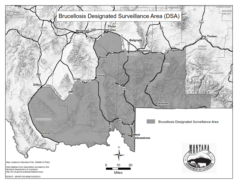
32.3.433 DESIGNATED SURVEILLANCE AREA (1) The designated surveillance area (DSA) of Montana is described as: (a) Park County – south of Interstate 90; (b) Gallatin County – south of Interstate 90 from the Park-Gallatin County line to U.S. Highway 191 at Bozeman, then south of U.S. Highway 191 to Highway 84, then south of Highway 84 to Churchill Road, then west of Churchill Road to Interstate 90 at Manhattan, then all other areas in Gallatin County south of Interstate 90, but west of Churchill Road; (c) Madison County – east of Highway 287 from its northern crossing of the Gallatin-Madison County line to Ennis, then south of State Highway 287 from Ennis to Alder, then east of State Rd. 357 (Upper Ruby Road) to Sweetwater Road, then south of Sweetwater Road to the Madison-Beaverhead County line; and (d) Beaverhead County – from Madison-Beaverhead County line, south of Sweetwater Road to East Bench Road near Dillon, then south of East Canal Bench Road to White Lane, then south of White Lane to Blacktail Road, then south of Blacktail Road to Highway 91, then west of Highway 91 to Interstate 15 business loop, then south of Interstate 15 business loop to Interstate 15, then east of Interstate 15 to the Montana/Idaho border. (2) A map of the designated surveillance area follows:
History: 81-2-102, 81-2-103, 81-2-104, MCA; IMP, 81-2-101, 81-2-102, 81-2-103, 81-2-104, MCA; NEW, 2011 MAR p. 147, Eff. 2/11/11; AMD, 2011 MAR p. 1551, Eff. 8/12/11; AMD, 2012 MAR p. 1258, Eff. 6/22/12; AMD, 2014 MAR p. 2141, Eff. 9/19/14. |
A directory of state agencies is available online at http://www.mt.gov/govt/agencylisting.asp.
For questions about the organization of the ARM or this web site, contact sosarm@mt.gov.