 Printer Friendly Version Printer Friendly Version
| 17.24.101 | GENERAL PROVISIONS |
(1) The Act and this subchapter provide that no person may engage in activities regulated under the Act without first obtaining the appropriate exploration license or operating permit from the department, or filing a valid small miner exclusion to the requirement of obtaining an operating permit. Activities regulated under the Act include:
(a) exploration for, or mining of minerals on or below the surface of the earth;
(b) engaging in ore processing;
(c) reprocessing of mine waste rock or tailings;
(d) constructing or operating a hard rock mill;
(e) using cyanide or other metal leaching solvents or ore-processing reagents; and
(f) disturbing land in anticipation of any of these activities.
(2) Prior to receipt of an exploration license or operating permit the applicant, other than a public or governmental agency, shall deposit with the department a reclamation performance bond in a form and amount as determined by the department in accordance with 82-4-338 , MCA. The license or permit may be issued following receipt and acceptance of the reclamation performance bond, and, at such time, operations may commence.
(3) Section 82-4-390, MCA, provides that open pit mining for gold or silver using heap leaching or vat leaching with cyanide ore-processing reagents is prohibited, except that a mine in operation on November 3, 1998, may continue operating under its existing operating permit or any amended permit that is necessary for continued operation of a mine.
(4) The mining of certain substances is excluded from the Act and this subchapter. See definition of "mineral" in 82-4-303, MCA.
(5) A small miner who signs an agreement described in 82-4-305, MCA, and does not violate the Act and this subchapter, is excluded from certain requirements of the Act as they relate to mining, except as noted in 82-4-305 , MCA. See definition of "small miner" in 82-4-303, MCA. All exploration operations, regardless of size, must comply with the requirements of 82-4-331 and 82-4-332, MCA, and ARM 17.24.103 through 17.24.108. See definitions of "exploration" in ARM 17.24.102 and "mining" in 82-4-303, MCA.
(6) The Act and this subchapter do not apply to a person engaging in a mining activity described in 82-4-310(1) and (2), MCA. The Act and this subchapter apply to a person who, on land owned or controlled by that person, is allowing other persons to engage in mining activities whose activities cumulatively exceed the activity described in 82-4-310(1), MCA.
(7) Subject to the exclusions set forth in the Act and pursuant to the definitions of "surface mining", "mining", "exploration" and "mineral" in the Act, placer or dredge mining, and rock quarrying are included in the application of the Act.
(8) As used in this subchapter, the term "operator" includes a licensee, a permittee, and a small miner. The Act covers the operator's employees and agents as well as subcontractors and the subcontractor's employees and agents. The operator is liable for violations of the Act by its employees, agents and subcontractors (drilling, construction, maintenance or otherwise) and the subcontractor's employees and agents when they are working on the project for which the permit or license was issued or which is subject to an exclusion.
(9) Common use pits and quarries on federal land which are available to the general public for the exclusive or nonexclusive procurement of rock or stone and which are administered by the responsible federal agency under appropriate regulations are not subject to these rules, pursuant to 82-4-309, MCA.
| 17.24.102 | DEFINITIONS |
As used in the Act and this subchapter, the following definitions apply:
(1) "Act" means Title 82, chapter 4, part 3, MCA.
(2) "Alternate reclamation" means the return of lands disturbed by mining or mining-related activities to a postmining land use other than that which existed prior to mining. Alternate reclamation must be stable, must have utility and must comply with Title 75, chapters 2, 5, and 6, MCA.
(3) "Bulkhead" means a door, fence or other construction which allows periodic entry to an adit or shaft, adequately secured and locked so that animals and unauthorized persons are denied entry.
(4) "Beneficial use" means use of water as defined in 85-2-102, MCA.
(5) "Collateral bond" means an indemnity agreement for a fixed amount, payable to the department, executed by the operator and supported by depositing with the department cash, negotiable bonds of the United States (not treasury certificates) , state or municipalities, negotiable certificates of deposit or an irrevocable letter of credit of any bank organized or authorized to transact business in the United States or other surety acceptable to the department.
(6) "Disturbed and unreclaimed" means, as used in the definition of "small miner" in 82-4-303, MCA, land affected by mining activities, including reprocessing of tailing or waste material, that has not been restored to a continuing productive use, with proper grading and revegetative procedures to assure:
(a) slope stability;
(b) minimal erosion;
(c) adequate vegetative ground cover (if in keeping with reclaimed use) ;
(d) that no mine discharge water, ground water or surface water passing through a disturbed area will pollute or contaminate any state waters.
(7) "Exclusion" means a statement filed by a small miner pursuant to 82-4-305 , MCA.
(8) "Exploration" includes pilot ore processing plants or sites and associated facilities constructed for the sole purpose of metallurgical or physical testing of ore materials, not to exceed 10,000 short tons, to aid in determining the development potential of an ore body.
(9) "Permit area" is the disturbed land as defined in 82-4-303, MCA, and a minimal area delineated around a disturbance area for the purposes of providing a buffer adjacent to all disturbances, and for the purposes of controlling public access to areas permitted under 82-4-335, MCA. Monitoring wells are not required to be within a contiguous permit boundary, but must be permitted. Other activities are to be included within the permit boundary as follows:
(a) Access roads must be included within the permit area from the point of departure with a public road to the mine site.
(b) Utilities are required to be permitted only within the permit area.
(c) Work camps are not required to be permitted. (However, they are regulated under Title 75, chapter 5, MCA.)
(10) "Placer or dredge mining" includes, but is not limited to, mining by hydraulic giant, ground sluice, rocker or sluice box methods, the use of a dry land dredge, trommel or washing plant, and bucket type floating dredges, all as referred to in Mining Methods and Equipment Illustrated, Montana Bureau of Mines and Geology, Bulletin 63, 1967.
(11) "Plan of operations" means the plans required under 82-4-335 through 82-4-337, MCA, including the reclamation plan defined in 82-4-303, MCA, plus the approved operating, monitoring and contingency plans required in an application for an operating permit.
(12) "Pollute or contaminate any stream" means, as used in 82-4-305, MCA, to conduct any mining or reprocessing of tailing or waste in a manner that will result in deterioration of water quality as specified by standards listed in ARM Title 17, chapter 30, et seq., pursuant to the Montana Water Quality Act, Title 75, chapter 5, et seq., MCA. Any future revisions of these standards adopted in accordance with the provisions of the Montana Water Quality Act, as amended, apply to this definition.
(13) "Reclamation" means the return of lands disturbed by mining or mining-related activities to an approved postmining land use which has stability and utility comparable to that of the premining landscape except for rock faces and open pits which may not be feasible to reclaim to this standard. Those rock faces and open pits must be reclaimed in accordance with 82-4-336 , MCA. The term "reclamation" does not mean restoring the landscape to its premining condition. Reclamation, where appropriate, may include, but is not limited to:
(a) neutralizing cyanide or other processing chemicals;
(b) closure activities for ore heaps, waste rock dumps, and tailing impoundments;
(c) closure activities for surface openings;
(d) grading, soiling and revegetating disturbed lands;
(e) removal of buildings and other structures that have no utility in regard to the approved postmine land use;
(f) other steps necessary to assure long-term compliance with Title 75, chapters 2 and 5, MCA; and
(g) other steps necessary to protect public health and safety at closure.
(14) "Revision" means a change to an operating permit that is exempt under 82-4-342, MCA, from the requirement to prepare an environmental assessment or environmental impact statement.
(15) "Significantly affect the human environment" means an affect on the human environment that meets the criteria of ARM 17.4.608.
(16) "Surety bond" means a surety agreement for a fixed amount, payable to the department, executed by a corporation licensed to do business as a surety in Montana, and guaranteeing performance of the obligations of the Act, the rules and the appropriate permit, exclusion or license.
| 17.24.103 | EXPLORATION LICENSE--APPLICATION AND CONDITIONS |
(1) To secure an exploration license an applicant shall:
(a) pay a filing fee of $100 to the department;
(b) submit an application for an exploration license to the department upon forms prepared and furnished by it;
(c) submit an exploration plan of operations and a map or sketch in sufficient detail to locate the area to be explored as well as the actual proposed disturbances, and to allow the department to adequately determine whether significant environmental problems would be encountered. The plan of operations must state the type of exploration techniques that would be employed in disturbing the land and include a reclamation plan in sufficient detail to allow the department to determine whether the specific reclamation and performance requirements of ARM 17.24.104 through 17.24.108 would be satisfied;
(d) agree to reclaim any surface area disturbed by the applicant during exploration operations, all as may be reasonably required by the department, unless the applicant shall have applied for and been issued an operating permit for the lands so disturbed;
(e) submit a reclamation performance bond with the department in a form and amount determined adequate by the department in accordance with 82-4-338, MCA; and
(f) not be in default of any other reclamation obligation mandated by the Act or rules implementing the Act.
(2) On approval by the department, the applicant will be issued an exploration license renewable annually by filing an annual report on a form provided by the department and payment of the renewal fee of $25.
(3) An exploration licensee is subject to and must agree to the provisions of ARM 17.24.104 through 17.24.107 for reclamation of surface areas disturbed by exploration operations. Because of the inherent difficulties of promulgating regulations of state-wide applicability, the department will allow variance from the following provisions of this rule, if a written request submitted prior to commencement of the subject disturbance is accompanied by the landowner's or land administrator's written consent to the variance and is sufficient to convince the department that the public interest and the intent of the Act are best served by allowing such variance.
(4) In the absence of emergency or suddenly threatened or existing catastrophe, the licensee may not depart from an approved plan without previously obtaining from the department verbal or written approval of the proposed change.
| 17.24.104 | EXPLORATION (TEMPORARY) ROADS |
(1) Insofar as possible, all roads must be located on benches, ridge tops and flatter slopes to minimize disturbance and enhance stability.
(2) Road widths may not exceed a 14 foot single lane standard. Turn-outs may be constructed according to the licensee's needs, but the turn-out area may not exceed 30 feet in total width.
(3) No road may be constructed up a stream channel proper or so close that material will spill into the channel. Minor alterations and relocations of streams may be permitted if the stream will not be blocked and if no damage is done to the stream or adjoining landowners. No alteration that affects more than 100 linear feet of the channel of a flowing stream may be approved by the department without advice from the Department of Fish, Wildlife and Parks. Any stream channel alterations must comply with Title 75, chapter 5, MCA.
(4) Road gradients must be kept low except for short pitches to take advantage of topography. Maximum sustained grades may not exceed 8%. Pitch maximum may not exceed 12% and may not be over 300 feet in length.
(5) Insofar as possible, the licensee must keep road cuts reasonably steep to minimize surface disturbances. Cut slopes may not be steeper than 1:1 in soil, sand, gravel, or colluvium; 1/4:1 in lake silts, or more than 0:1 in rock. Where necessary to prevent significant sloughing or slumping, the top of road cuts must be rounded back to a more gentle slope. In selecting a slope angle, to prevent slope failure the licensee should consider at least the following factors: the nature of the material, compaction, slope height and moisture conditions.
(6) A ditch must be provided on both sides of a throughcut and, with the exception of outsloping roads, on the inside shoulder of a cut-fill section, with ditch relief cross drains (water bars) being spaced according to grade. Water must be intercepted before reaching a switchback or large fill, and be routed and released below the fill or switchback, not over it.
(7) Streams must be crossed at or near right angles unless contouring down to the stream bed will result in less potential stream bank erosion. Structure or ford entrances and exits must be constructed to prevent water from flowing down the roadway.
(8) Culverts must be installed at prominent drainage ways, small creeks and springs. Upon abandonment of the road, culverts must be removed and the drainage way reopened. Such culverts must be sufficient to handle runoff expected from a statistical five-year storm and, where necessary, the area adjoining the culvert must be protected from erosion by adequate, inert rock riprap.
(9) Trees and vegetation may be cleared for only the essential width necessary to maintain soil stability and to serve traffic needs. Trees must be felled prior to road construction. When sideslopes are 15% (8.5�) or less, trees and other vegetative debris from clearing operations must be completely disposed of, stockpiled at specified areas, or used as a sediment filter below the road cut. When sideslopes are steeper than 15% (8.5�) , trees and vegetative debris shall be piled neatly below and parallel to the toe of the fill.
(10) Drainage facilities (such as culverts and water bars) must be installed as road construction progresses.
(11) Adequate diagonal drainage barriers (i.e., water bars, drain dips or similarly effective features) must be placed at the following specified intervals:
�
| ��� |
Grade (%) |
� |
Maximum Spacing (feet) |
|
� |
0 - 2 |
� |
200 |
|
� |
3 - 8 |
� |
150 |
|
� |
9 - 12 |
� |
80 |
(12) Roads must be outsloped whenever possible. If roads are to be used during snow season, insloping with proper drainage consideration is acceptable for vehicle safety reasons.
(13) Snowplowing must be done in such a manner that runoff water will not be trapped between the snow berms and flow down the road.
(14) Materials which slough or slump onto the road bed or into the roadside drainage ditch before the licensee completes the exploration project must be disposed of on the road bed or on the fill material in a manner that will not obstruct any of the drainage facilities previously described.
(15) All fill and cut slopes, with the exception of rock faces, must be seeded or planted or both during the first appropriate season following construction of the road.
(16) The department may waive any of the criteria in this section if the applicant proposes methods or technologies that achieve the same or better environmental protection than that expected under the given criteria.
| 17.24.105 | CONDUCT OF EXPLORATION OPERATIONS |
(1) All suitable practically salvaged soil and soil material must be salvaged prior to any other site disturbance, and either stockpiled or used for immediate reclamation.
(2) Except for samples, drilling mud, water and other fluids as well as waste cuttings from drilling operations must be confined to the drill site by the use of storage tanks or sumps or must be disposed of in accordance with a plan approved by the department.
(3) Drill sites must not be constructed in natural flowing streams.
(4) Areas disturbed by removal of vegetation or grading must be kept to the minimum size necessary to accommodate the exploration operation.
(5) Insofar as possible, trenches, discovery pits and other excavations must be located out of natural flowing streams.
(6) Spoil from pits, trenches, shafts, adits, or other excavations must not be located in drainage ways. The lower edge of the spoil bank must be at least five vertical feet above high flow level. Exceptions may be made when it is not physically practical to place spoil at least five vertical feet above the high flow level.
(7) Oil, grease, hydraulic fluid and other petroleum products must not be released on the exploration site. If a release occurs, the contaminated material must be removed immediately and disposed of at a proper disposal site.
(8) Exploration adits, shafts, and other excavations must be secured from unauthorized entry throughout the life of the operation to ensure public safety.
(9) Pilot ore processing plants or sites, as included in the definition of "exploration" in ARM 17.24.102, and permitted under an exploration license, are subject to all applicable requirements of 82-4-335 through 82-4-337 , MCA.
(10) The department may require interim revegetation for the purposes of erosion control on all exploration disturbance areas.
| 17.24.106 | EXPLORATION DRILL HOLE PLUGGING |
(1) Except as provided in (3) of this rule, all exploration drill holes must be plugged at the surface five to ten feet with cement.
(2) Except as provided in (3) of this rule, exploration drill holes must be plugged with bentonite or a similar compound from the bottom of the hole to within five to ten feet of the surface, and with cement from the top of the bentonite to the surface if one or more of the following conditions apply:
(a) two aquifers are intercepted;
(b) one aquifer is intercepted and an existing or potential beneficial use (domestic, agricultural or fish/ wildlife water supply) exists;
(c) one or more artesian aquifers are intercepted causing either surface flow or significant water rise in the hole; or
(d) the potential exists for downward water loss from an aquifer (cascade effect) as determined by the department.
(3) Exceptions to (1) and (2) of this rule may be granted by the department if:
(a) shallow placer holes are drilled using a churn or percussion drill or similar equipment in alluvium in which the holes will be obliterated as the drill stem is withdrawn, leaving no evidence of the hole;
(b) the drill hole contained no water, is not geologically likely to contain water or the hole is to be destroyed during mining or mining related disturbances;
(c) the drill hole is developed into a water well, monitoring well, or piezometer with the written agreement of the land owner and to the specifications of the appropriate state agency; or
(d) other site-specific hydrogeological and topographic situations necessitate exceptions.
(4) All drill holes must be plugged prior to removing the drill rig from a hole unless removing the drill rig is necessary to the hole plugging operation or unless otherwise approved by the department.
(5) If the flow of an artesian drill hole is not completely stopped, after exhaustion of all methods, the operator must:
(a) obtain a discharge permit from the Department of Environmental Quality; or
(b) develop a water well in compliance with the requirements of other applicable local, state and federal statutes, including water rights. In addition, the land owner must concur, the amount and use of flow must be compatible with the approved postmining land use, and the water quality must meet standards set under the Title 75, chapter 5, MCA.
(6) In areas and geological formations of known artesian well potential, bonding for drill sites must be adequate to ensure artesian hole plugging.
| 17.24.107 | RECLAMATION REQUIREMENTS--EXPLORATION |
(1) Upon completion of the drilling operation, drill cuttings or core must be removed from the site, disposed of down the hole, or buried. Drilling mud and other nontoxic lubricants must be removed from the site or allowed to percolate into the ground prior to backfilling the sump.
(2) Unless the hole is completed under ARM 17.24.106(3)(c), collar pipe or casing must be removed or cut off below ground level.
(3) Access roads constructed by the licensee to accommodate the exploration project must be returned to a stable slope that approximates the original contour to the extent possible. Where this is not possible (as determined by the department) , compacted surfaces must be ripped or otherwise loosened, drainage structures must be installed in accordance with ARM 17.24.104(11), and the roads must be closed to access by use of locked gates, kelly humps/dips, or other effective method. Exceptions may be made in accordance with the provisions of ARM 17.24.103(3). This requirement may be waived by the department if the landowner requests in writing that the access road be left in place for an identified, alternative, feasible and practicable purpose.
(4) Drill sites constructed by the licensee must be returned to a stable configuration that approximates the original contour to the extent possible. Where the department determines that this is not possible, compacted surfaces must be ripped or otherwise loosened and appropriate drainage must be provided. This requirement may be waived by the department if the landowner requests in writing that the drill site be left in place for an identified, feasible and practicable purpose.
(5) When such actions will not obscure significant evidence relating to the possible presence of an ore deposit or physically hinder further development of the claim, all trenches, bulk sample or discovery pits, and other excavations must be backfilled with the excavated spoil material. If, following a site investigation and discussions with the licensee, the department confirms the necessity for the excavation to remain open, backfilling requirements may be postponed providing the licensee remains in compliance with 82-4-331, and 82-4-332, MCA, and ARM 17.24.103, 17.24.105, and 17.24.153.
(6) Upon termination of the exploration project, the first 25 feet of all adits must be backfilled with waste rock or riprap which will not contribute to the degradation of any discharge water. Shafts must also be backfilled or otherwise securely sealed upon project termination. If, following a site investigation and discussions with the licensee, the department confirms the necessity for an adit or shaft to remain accessible for possible future exploration or development, the adit or shaft must be secured with a steel bulkhead or other equally effective method to prevent unauthorized entry and ensure public safety.
(7) All refuse, buildings, railroad track, and other facilities associated with the exploration project must be removed and disposed of in proper disposal sites. Exceptions may be made by the department if the licensee desires to mine the area and is in compliance with 82-4-332 (4) , MCA. This requirement may also be waived by the department if the landowner requests in writing that specific facilities be left in place for an identified, alternative, feasible and practicable purpose.
(8) All compacted surfaces associated with exploration adits, shafts, pits and associated facilities shall be ripped or otherwise loosened prior to soil replacement.
(9) Unless other reclamation practices are approved by the department, waste dumps associated with new adits excavated for the purposes of underground exploration must be contoured to allow for soil replacement and successful vegetation establishment. When existing, caved (sloughed) adits are reopened for the purposes of exploration and the caved material can be confined to the existing portal pad or waste dump without requiring expansion, contouring is not required. However, the licensee shall provide for appropriate drainage in the portal area, and the portal pad and waste dump must be stabilized with vegetation or by employing other stabilization methods determined acceptable by the department.
(10) Where feasible, soil and soil materials salvaged during construction must be reapplied over all disturbance areas.
(11) Where feasible, all disturbed areas must be revegetated with a seed mixture that is approved by the department.
(12) Appropriate revegetation must be accomplished as soon after necessary grading as possible; however, revegetation must be performed in the proper season in accordance with accepted agricultural and reforestation practices.
(13) In the event that any of the above revegetation efforts are unsuccessful, the licensee must seek the advice of the department and make a second attempt, incorporating such changes and additional procedures as may be expected to provide satisfactory revegetation.
| 17.24.108 | EXPLORATION RECLAMATION DEFERRED |
(2) The licensee shall comply with the following conditions of a reclamation deferral:
(a) a current exploration license shall be maintained;
(b) a current and adequate bond shall be maintained;
(c) the licensee shall be actively pursuing an operating permit or have filed a valid exclusion; and
(d) the licensee shall observe any interim monitoring or reclamation requirements as may be reasonably required by the department.
(3) The department shall cancel the deferral and issue an order to reclaim if the licensee fails to meet any of the conditions outlined in (2) , listed above.
| 17.24.115 | OPERATING PERMITS: RECLAMATION PLANS |
(a) land disturbed by development or mining activities must be reclaimed for one or more specified uses, including, but not limited to: forest, pasture, orchard, cropland, residence, recreation, wilderness, industry, habitat (including food, cover or water) for wildlife or other uses. Proposed reclamation need not reclaim subject disturbed areas to a better condition or different use than that which existed prior to development or mining. The applicant must describe:
(i) current uses(s) of area to be disturbed;
(ii) current and proposed uses of nearby land that by its proximity may influence or guide the choice of a reclaimed use of the disturbed area;
(iii) pertinent climatic, topographical, soil, water and wildlife data that govern choice of proposed use of the reclaimed land.
(b) With the use of cross-sections, topographic maps or detailed prose, the proposed topography of the reclaimed land must be adequately described. As specific situations warrant, proper grading must provide for adequately designed contour trenches, benches and rock-lined channelways on disturbed areas. The applicant must submit evidence to assure the department that upon partial or complete saturation with water, graded fill, tailings or spoil slopes will be stable. The proposed grading methods must be described. Where practicable, soil materials from all disturbed areas must be stockpiled and utilized.
(c) The operator must establish vegetative cover commensurate with the proposed land use specified in the reclamation plan.
(d) Where operations result in a need to prevent acid drainage or sedimentation, on or in adjoining lands or streams, there shall be provisions for the construction of earth dams or other reasonable devices to control water drainage, provided the formation of such impoundments or devices shall not interfere with other landowner's rights or contribute to water pollution (as defined in Title 75, chapter 5, MCA) .
(e) All water, tailings or spoil impounding structures must be equipped with spillways or other devices that will protect against washouts during a 100 year flood.
(f) Upon abandonment, water from the development or mining activities shall be diverted or treated in a manner designed to control siltation, erosion or other water pollution damage to streams and natural water courses.
(g) All operations shall be conducted so as to avoid range and forest fires and spontaneous combustion.
(h) Proper precautions must be taken to assure that exposed cuts and tailings or spoil disposal areas will not be subject to wind erosion to the extent that airborne detritus becomes a public nuisance or detriment to the flora and fauna of the area.
(i) In a reclamation plan, the applicant shall provide the department with sufficiently detailed information regarding method(s) of disposal of mining debris, including mill tailings, and the location and size of such areas.
(j) Requirements regarding reclamation of stream channels and stream banks must be flexible to fit circumstances of each stream site. Many stream relocations, however, will be permanent and thus will represent the reclaimed condition of stream channels and stream banks. Accordingly, reclamation plans must contain the following provisions should stream channels or banks be permanently relocated:
(i) the relocation channel shall be of a length equal to or greater than the original channel, unless the department after consideration of the local circumstance shall grant a variance;
(ii) the relocation channel shall contain meanders, riffles and pools similar to those in the original channel;
(iii) stream banks shall be rounded to prevent slumping and sloughing and shall be revegetated in keeping with accepted agriculture or reforestation practices the first appropriate season following channel relocation;
(iv) rock riprap shall be used wherever appropriate.
(k) Sections 82-4-332 and 82-4-335 , MCA, require that maps of the intended development or mining operation(s) accompany applications for permit. Should a copy of such maps, to scale, contain the following additional information (transparent overlays are acceptable) , a separate map need not accompany the reclamation plan:
(i) outline of the area to be disturbed in the first year of operation;
(ii) outline of areas where soil materials will be replaced;
(iii) outline of intended revegetation areas showing plant or seed densities and species chosen;
(iv) location of such structures, drainage features, etc., as may be necessary to prevent erosion of bare slopes and subsequent siltation or other pollution of natural flowing streams or other natural water bodies.
(l) Reclamation shall be as concurrent with development or mining operations as feasible and must be completed within a specified reasonable length of time. Revegetation must be accomplished in the first appropriate season after necessary grading, in accordance with accepted agricultural or reforestation practices.
(m) All facilities constructed as part of the operating permit must be reclaimed for the approved postmine land use. The reclamation plan must provide for removal of buildings and other structures at closure consistent with the postmine land use.
(n) The plan must provide for postmine environmental monitoring programs and contingency plans for the postreclamation permit area. The monitoring programs and contingency plans must be related in scope and duration to the risk to public safety, water quality and adjacent lands they were designed to address.
| 17.24.116 | OPERATING PERMIT: APPLICATION REQUIREMENTS |
(1) Applicant must obtain an operating permit for each mine complex on a form prescribed by the department.
(2) To obtain an operating permit the applicant shall pay a $500 fee.
(3) In addition to the information required by 82-4-335 (4) , MCA, an application for an operating permit must describe the following:
(a) the existing environment;
(b) soil salvage and stockpiling activities and measures to protect soil from erosion and contamination;
(c) provisions for the prevention of wind erosion of all disturbed areas;
(d) the design, construction, and operation of the mine, mill, tailings, and waste rock disposal facilities;
(e) the facilities, buildings, and capacity of mill or processing;
(f) the proposed date for commencement of mining, the minerals to be mined, and a proposed conceptual life of mine operations;
(g) the designs of diversions, impoundments, and sediment control structures to be constructed reflecting their safety, utility, and stability;
(h) the location of access, haul, and other support roads and provisions for their construction and maintenance that control and minimize channeling and other erosion;
(i) the source and volume of incoming ore, tailings, or waste rock;
(j) the equipment and chemicals to be used in the operation by location and task;
(k) the general chemical processes and the purpose, amount, and source of water used in the operation and the disposition of any process waste water or solutions;
(l) the ground and surface water monitoring programs to be implemented and a contingency plan addressing accidental discharges to ground or surface water;
(m) a fire protection plan;
(n) a toxic spill contingency plan with certification that notice of the filing of the plan has been provided to the state fire marshal;
(o) the sewage treatment facilities and solid waste disposal sites;
(p) the power needs and source(s) , including fuel storage sites;
(q) the anticipated employment including direct and onsite contract employees;
(r) the transportation network to be used during the construction and operation phases, including a list of the type and amount of traffic at mine or mill capacity;
(s) the predicted noise levels by activities during construction and operations;
(t) the protective measures for archaeological and historical values in the areas to be mined;
(u) the protective measures designed to avoid foreseeable situations of unnecessary damage to flora and fauna in or adjacent to the area.
(4) The application must include a map or maps to scale of the mine area and area to be disturbed (such map must locate the proposed mine and facilities and must locate and identify streams, and proposed roads, railroads, and utility lines in the immediate area and residences and wells within one mile of the permit area) . All maps provided in the application must have a uniform base, a scale, and a north directional arrow.
(5) The application must include a reclamation plan that meets the requirements of 82-4-336 , MCA, and this subchapter.
| 17.24.117 | PERMIT CONDITIONS |
(1) The following conditions accompany the issuance of each permit:
(a) The permittee shall conduct all operations as described in:
(i) the plan of operations including the approved operating, reclamation, monitoring, and contingency plans;
(ii) any express conditions which the department places on the permit to ensure compliance with the Act or this subchapter promulgated pursuant thereto;
(iii) written commitments made by the permittee in response to deficiencies identified by the department during the permit application review process;
(iv) mitigation measures mutually developed by the department and permittee pursuant to 75-1-201(4)(b), MCA; and
(v) plans or assumptions used in calculating bond amounts that have been posted by the permittee.
(b) If the department issued the permit because the applicant was maintaining a good faith direct appeal in accordance with 82-4-335, MCA, the permittee will immediately submit proof upon resolution of the appeal that the violation has been or is being corrected to the satisfaction of the regulatory agency or the permittee will cease operations.
(c) Except as provided in ARM 17.24.144(1)(f) and 17.24.146(2), the permittee shall maintain in effect at all times a bond in the amount established by the department. Upon failure of the permittee to maintain such bond coverage because of expiration or cancellation of bond, the permit is suspended and the permittee shall cease mining operations until substitute bond is filed with and approved by the department.
| 17.24.118 | ANNUAL REPORT |
(2) The annual report must include the information outlined under 82-4-339 , MCA. In addition, the annual report must include:
(a) the number of acres of land affected by the operation during the preceding year and cumulatively;
(b) the extent of backfilling and grading performed during the preceding year and cumulatively;
(c) the area of land planted;
(d) the type of planting or seeding;
(e) the mixtures and amounts seeded;
(f) the species, location, and method of planting for site or species specific plantings;
(g) the date of seeding or planting;
(h) cumulative acres reseeded to date;
(i) cumulative acres of completed reclamation and the date each increment was completed; and
(j) maps showing the information required in (2) (a) through (i) .
(3) Each annual report must include an inventory of soils volumes which includes:
(a) cubic yards salvaged in the preceding year and cumulatively;
(b) cubic yards to be salvaged in the coming year;
(c) cumulative volume of soils contained in stockpiles; and
(d) replaced soil depths and volumes.
(4) Each annual report for those operations using cyanide or other metal leaching solvents or reagents or having the potential to generate acid must provide a narrative summary of water balance conditions during the preceding year and identify excess water holding capacity at the time of the annual report.
(5) When incremental bond has been approved, additional bond must be submitted, in the amount required, with the annual report and the status of incremental bonding must be described.
(6) If changes in facilities have occurred in the preceding year, the annual report must, pursuant to 82-4-339 (1) (f) , MCA, update the permit map required under ARM 17.24.115. The updated map must depict all approved surface features, as required by the department, in or associated with the permit area, reproduced at a scale applicable for field use.
(7) If cultural resource mitigations identified in the permit will be ongoing through the life of the operation, the annual report must include an updated cultural resource management table, including a list of sites mitigated and disturbed in the preceding year and sites to be mitigated and disturbed in the coming year.
(8) If comprehensive water monitoring is required by the permit, each annual report must include an evaluation of water monitoring reports submitted during the preceding year. The evaluation must include trend analyses for those key site-specific parameters required by the department in the permit.
(9) If site-specific geologic conditions identified in the permit indicate the need for geologic monitoring, each annual report must include monitoring results and must report materials balances as required in the permit.
(10) If site-specific closure requirements identified in the permit include monitoring for cyanide or other metal leaching solvent or reagent neutralization, acid rock drainage development, or similar occurrences, the annual report must include an evaluation of monitoring and testing data required in the permit for closure under 82-4-335 , MCA.
(11) Each annual report must include the names of key personnel for maintenance and monitoring if the operation is shut down.
(12) Each annual report must include any other relevant information required by the permit.
(13) The department shall, by certified mail, notify a permittee, who fails to file an annual report and fee as required by this rule, that the permit will be suspended if the report and fee are not filed within 30 days of receipt of the notice.
(14) If a permittee fails to file an annual report and fee within 30 days of receipt of a notice, the department shall suspend the permit.
| 17.24.119 | PERMIT AMENDMENTS |
(1) An application for a major amendment must:
(a) contain a summary of changes in disturbances, in resources affected, and in construction, operating, reclamation, monitoring, and contingency plans;
(b) provide dated replacement or supplemental resource data, plans, and maps as outlined in ARM 17.24.115, or cross reference applicable data, plans, or maps in the previously permitted plan of operation, in order to identify the existing environment and resources affected, as well as changes in permit boundaries, in total disturbances, and in construction, operating, reclamation, monitoring, and contingency plans;
(c) identify any additional resource data necessary to the evaluation of the proposed amendment;
(d) provide an updated or comprehensive facilities map; and
(e) clearly indicate on the facilities map all bonding areas subject to pre-July 1, 1974, bonding levels. No action under this subsection affects a bond in effect under pre-July 1, 1974, bonding levels.
(2) For an application for a major amendment, the department shall implement the application, notice and hearing requirements for new permits pursuant to 82-4-337 and 82-4-353, MCA, and prepare necessary environmental analyses pursuant to the Montana Environmental Policy Act.
(3) An application for minor amendment must:
(a) contain a summary of proposed changes in sufficient detail for the department to determine whether further environmental analysis under Title 75, chapter 1, MCA, is required;
(b) contain dated replacement pages and necessary supplemental resource data and plans, and maps in order to identify changes in permit boundaries, total disturbances, and plans;
(c) contain an updated or comprehensive facilities map;
(d) contain a statement of the applicant's rationale for asserting nonsignificance pursuant to 82-4-342(5), MCA;
(e) identify previous environmental analyses relevant to the amendment; and
(f) clearly indicate on the facilities map all bonding areas subject to pre-July 1, 1974, bonding levels. No action under this section affects a bond in effect under pre-July 1, 1974, bonding levels.
(4) For a minor amendment, the department shall not implement the application, notice and hearing requirements for new permits pursuant to 82-4-337 and 82-4-353, MCA. The department shall provide the permittee with a notice of decision on the adequacy of the minor amendment application within 30 days of receipt of the application.
| 17.24.120 | PERMIT REVISIONS |
(1) An application for revision must include:
(a) a general summary explaining the revision;
(b) a statement of the applicant's rationale for asserting nonsignificance pursuant to 82-4-342(5), MCA;
(c) identification of previous environmental analyses relevant to the revision;
(d) a reference to prior commitments to topsoil salvage, sediment control, reclamation, and other previously approved plans or standards that are applicable to the revision;
(e) documentation of the adequacy of existing bonding, if appropriate;
(f) updated replacement pages and permit map for the permitted plan of operations;
(g) any necessary construction, operating, reclamation, monitoring, and contingency plans; and
(h) an updated or comprehensive facilities map that clearly indicates all areas subject to pre-July 1, 1974, bonding levels. No action under this subsection affects a bond in effect under pre-July 1, 1974, bonding levels.
(2) The department shall provide the permittee with a notice of adequacy of proposed revisions within 30 days of receipt of the application.
| 17.24.121 | PERMIT REVIEWS |
(1) At any time during the life of an operation, the department may review an operating permit.
(2) If the department determines that the modification of the reclamation plan is authorized under 82-4-337(4), MCA, it may require such modification under the procedures of (3) through (6).
(3) The department shall send an explanation of the need for modification and a conceptual plan for modification to the permittee, by certified mail, and provide opportunity for hearing, pursuant to Title 2, chapter 4, part 6, MCA.
(4) The permittee shall respond to the department with a request for hearing or a proposed schedule for modification or revision, not to exceed one year, within 30 days of receipt of a letter from the department.
(5) The department may extend the one-year time frame or the time for hearing request for good cause documented by the permittee in writing.
(6) A modification must be submitted in the form of an amendment or a revision and the department shall process the applicant's submittal in accordance with ARM 17.24.119 or 17.24.120.
| 17.24.122 | PERMIT ASSIGNMENT |
(2) The permittee shall:
(a) provide the department with a completed application on a form, provided by the department, which includes:
(i) the name and address of the proposed assignee and the name and address of that person's resident agent, if any; and
(ii) the same information as is required in 82-4-335 (4) , (8) , and (9) , MCA, for applications for new permits.
(3) The assignee shall:
(a) commit in writing to conduct the operations in full compliance with the terms and conditions of the permit; and
(b) provide sufficient bond to guarantee performance of the Act, this subchapter and the permit.
| 17.24.123 | PERMIT CONSOLIDATION |
(2) In order to obtain permit consolidation, the permittee must submit an application containing the following information:
(a) an explanation of the purpose of the consolidation and a summary of cumulative disturbances;
(b) a single map showing the entire proposed permitted area;
(c) a table showing the consolidated acreage of permitted areas, total permitted disturbance, and total acreage reclaimed to date;
(d) an updated facilities map showing all facilities modifications that have occurred since the issuance of the individual permits. This map may be combined with the permit area map required under (b) above if there is no loss in legibility;
(e) a consolidated bonding map showing what areas, if any, are subject to pre-July 1, 1974, bonding levels and showing which bonds cover which areas; and
(f) a consolidated operating and reclamation plan and supporting maps, showing, as appropriate, the area to which each plan applies. No action under this subsection affects a bond in effect under pre-July 1, 1974, bonding levels.
(3) Following consolidation, annual reports must be submitted on the renewal date of the oldest of the permits to be consolidated.
| 17.24.128 | INSPECTIONS: FREQUENCY, METHOD, AND REPORTING |
(1) The department shall conduct an inspection:
(a) at least once per calendar year for each permitted operation; and
(b) at least three times per year for each active operation that:
(i) uses cyanide or other metal leaching solvents or reagents;
(ii) has expected or ongoing acid rock drainage; or
(iii) exceeds 1000 acres in permit area.
(2) The department shall provide copies of operating permit inspection reports to any appropriate state or federal land managing agency, if requested by the agency.
(3) The department shall provide a copy of each report to the operator.
| 17.24.129 | INSPECTIONS: RESPONSE TO CITIZEN COMPLAINTS |
(1) Any person may request an inspection by the department of any operation by furnishing the department with a signed statement, or an oral report followed by a signed statement, giving the department reason to believe that there exists a violation of the Act, the rules adopted pursuant thereto, the permit, the license, or the exclusion; or that there exists a condition or practice that creates an imminent danger to the public or that is causing or can be reasonably expected to cause a significant, imminent environmental harm to land, air, or water resources. The statement must identify the basis for the allegation or provide corroborating evidence. The statement must be placed in the alleged violator's file and becomes a part of the permanent record. The identity of the person supplying information to the department must remain confidential with the department, if requested by that person.
(2) If the report provides the information required above and the department determines the request to present sufficient evidence to warrant a special inspection, the department shall conduct an inspection to determine whether the condition, practice, or violation exists or existed.
(3) Within 30 days of receipt of the requestor's written statement, the department shall send the requestor and the alleged violator a written response which includes the following:
(a) if an inspection was made, a description of the enforcement action taken, or, if no enforcement action was taken, an explanation of why no enforcement action was taken;
(b) if no inspection was made, an explanation of the reason why.
| 17.24.132 | ENFORCEMENT: PROCESSING OF VIOLATIONS AND PENALTIES |
(1) Except as provided in (4), the department shall send a violation letter for a violation of the Act, this subchapter, or the permit, license, or exclusion. The violation letter must be served and must state that the alleged violator may, by filing a written response within a time specified in the notice, provide facts to be considered in further assessing whether a violation occurred and in assessing the penalty under (2).
(2) The department may issue a notice of violation and administrative order for a violation identified in a violation letter. The administrative order may assess a penalty, require corrective action, or both.
(3) The alleged violator may, within 30 days of service of the notice of violation and order, respond in writing and may request an informal conference, a contested case hearing, or both, on the issues of whether the violation occurred, whether the corrective action ordered by the department is reasonable, and whether the penalty assessed is proper.
(4) If a contested case hearing has not been requested within 30 days of the date of service of the order, the notice of violation and order become final. If a contested case hearing has been requested, the board shall hold a hearing, make the findings of fact, issue the decision, and, if a violation is found, order payment of any penalty as provided in 82-4-361, MCA.
�
| 17.24.133 | ENFORCEMENT: ABATEMENT OF VIOLATIONS AND PERMIT SUSPENSION |
(2) The director may, after opportunity for an informal conference, suspend a permit or license for a violation of the Act, this subchapter, or the license or permit that:
(a) may reasonably be expected to create a danger to the health or safety of persons outside the permit area;
(b) may reasonably be expected to cause significant environmental harm to land, air, or water resources; or
(c) remains unabated subsequent to the deadline contained in a corrective action order.
| 17.24.134 | ENFORCEMENT: ASSESSMENT OF PENALTIES |
| 17.24.136 | ORDERS: ISSUANCE AND SERVICE |
(a) delivering a copy of the order in person to the violator; or
(b) sending a copy of the order by certified mail to the violator at the address on the violator's application for a license or permit or exclusion.
(2) Service is complete upon tender of the order in person. Service by mail is complete within three business days after the date of mailing and is not incomplete because of refusal to accept.
| 17.24.137 | NOTICES AND ORDERS: EFFECT |
(2) If a suspension order will not completely abate the imminent danger to the health or safety of persons outside the permit or license area in the most expeditious manner physically possible, the director or the director's authorized representative shall impose affirmative obligations on the person to whom it is issued to abate the condition, practice, or violation. The order must specify the time by which abatement must be accomplished and may require, among other things, the use of existing or additional personnel and equipment.
(3) A notice or order may not be vacated because of inability to comply.
(4) If a permit or license has been suspended or revoked, the operator or licensee may not conduct any operations or prospecting pursuant to the permit or license and shall:
(a) if the permit or license is revoked, complete reclamation within the time specified in the order;
(b) if the permit or license is suspended, abate all conditions, practices, or violations, as specified in the order.
| 17.24.140 | BONDING: DETERMINATION OF BOND AMOUNT |
(a) costs estimated by using current machinery production handbooks and publications or other documented costs acceptable to the department;
(b) the additional estimated costs to the department which may arise from additional design work, applicable public contracting requirements or the need to bring personnel and equipment to the operating area after its abandonment by the operator;
(c) an additional amount based on factors of cost changes during the preceding five years for the types of activities associated with the reclamation to be performed; and
(d) the additional estimated cost to the department which may arise from management, operation, and maintenance of the site upon temporary or permanent operator insolvency or abandonment, until full bond liquidation can be effected.
(2) The total bond amount calculated by the department must be in place and accepted by the department prior to issuance of the permit, license, or exclusion unless:
(a) the applicable plan identifies phases or increments of disturbance which may be individually identified and for which individual, incremental bonds may be calculated. The plan must provide for bonding increments to be submitted with the annual report and must expressly state that the operator, licensee or small miner may not proceed to the next phase or increment until the bond is in place and has been approved in writing by the department; or
(b) mining will proceed through a progression of contiguous pits and the plan provides for concurrent backfill. In this case, the bond must include the amount necessary to backfill the largest volume pit.
(3) An incremental bond proposal must not be accepted if the operator has received a bonding noncompliance, notice of violation for exceeding the small miner or other acreage limitations, or a notice of violation for conducting activities outside the bonded operating area. This prohibition does not apply if the violation is vacated or if a court rules that a violation did not occur.
(4) Unless the provisions of the bond provide otherwise, the line items in the bond calculations are estimates only and are not limits on spending of any part of the bond to complete any particular task subsequent to forfeiture of the bond or settlement in the context of bond forfeiture proceedings.
(5) An operator may submit bond higher than the amount required by the department. The extra amount remains unobligated to any disturbance until applied against disturbances which result from additional activities approved under an operating permit, license, or exclusion.
(6) Bond released from completed activities may not be applied to subsequent activities or increments until the department has inspected the site, provided public notice and opportunity for comment on the release, and approved the request for release in compliance with 82-4-338 , MCA.
| 17.24.141 | BONDING: ADJUSTMENT OF AMOUNT OF BOND |
(2) The department shall conduct an overview of the amount of each bond annually and shall conduct a comprehensive bond review at least every five years. The department may conduct additional comprehensive bond reviews if, after modification of the reclamation or operation plan, and annual overview, or an inspection of the permit area, the department determines that an increase of the bond level may be necessary.
(3) If, at the time of an amendment under ARM 17.24.119, a comprehensive bond review is completed, the next comprehensive bond review must occur not more than five years after the issuance of the amendment.
(4) The department shall notify the operator of any proposed bond adjustment and provide the operator an opportunity for an informal conference on the adjustment.
(5) For bond reduction requests by the operator for release of undisturbed land, the operator shall submit a map of the area in question, revise the appropriate active operation maps and document that the area has not been disturbed as a result of previous operating activities. The department shall then conduct an inspection of the proposed area before responding to the request.
(6) An operator or an interested party may request an adjustment of the required performance bond amount upon submission of evidence to the department demonstrating that the method of operation or other circumstances will change the estimated cost to the department to complete the reclamation, contingency procedures, or monitoring activities and therefore warrant a change in the bond amount.
(7) A bond filed for an operating permit obtained under 82-4-335 , MCA, may not be released or decreased until the public has been provided an opportunity for a hearing and a hearing has been held if requested. The department shall provide reasonable statewide and local notice of the opportunity for hearing including, but not limited to, circulation. The department shall provide a 30-day comment period in the notice. A request for hearing must be submitted to the department in writing within the comment period.
| 17.24.142 | BONDING: REPLACEMENT OF BOND |
(2) The department may not release an existing performance bond until the operator has submitted and the department has approved an acceptable replacement performance bond. A replacement of performance bond pursuant to this rule does not constitute a release of bond under 82-4-338 , MCA.
| 17.24.143 | BONDING: FORM OF BOND |
(2) Liability under any bond, including separate bond increments and indemnity agreements applicable to a single operation, must extend to the entire bonded area.
| 17.24.144 | BONDING: SURETY BONDS |
(a) The department may not accept a surety bond in excess of 10% of the surety company's capital surplus account as shown on a balance sheet certified by a certified public accountant.
(b) The department may not accept a surety bond from a surety company for any person, on all permits held by that person, in excess of three times the company's maximum single obligation as provided in (a) above.
(c) The department may not accept a surety bond from a surety company for any person, on all permits held by that person, unless that surety is registered with the state auditor and is listed in the United States Department of the Treasury Circular 570 as revised.
(d) A power of attorney must be attached to the surety bond.
(e) The surety bond must provide a mechanism for the surety company to give prompt notice to the department and the operator of:
(i) any action alleging bankruptcy or insolvency of the surety or violation that would result in suspension or revocation of the license of the surety;
(ii) cancellation by the operator; and
(iii) cancellation or pending cancellation by the surety.
(f) Upon incapacity of a surety by reason of bankruptcy, insolvency or suspension or revocation of its license, the operator shall be deemed to be without bond coverage and shall promptly notify the department in the manner described in the bond. The department, upon notification, shall, in writing, notify the operator of a reasonable period, not to exceed 90 days, to replace bond coverage. If an adequate bond is not posted by the end of the period allowed, the operator shall cease mineral extraction, comply with the provisions of 82-4-336 (1) , MCA, and immediately commence reclamation in accordance with the Act, this subchapter and the reclamation plan. Mining operations must not resume until the department has determined that an acceptable bond has been posted.
(g) Whenever operations are abandoned concurrent with cancellation of the bond, the department must reclaim the site and forfeit the bond within two years, consistent with 82-4-341 , MCA, for any reclamation obligation incurred in the reclamation of the site.
| 17.24.145 | BONDING: CERTIFICATES OF DEPOSIT |
(2) The department may accept only automatically renewable certificates of deposit from a United States bank.
(3) The department shall require the operator to deposit sufficient amounts of certificates of deposit, to assure that the department will be able to liquidate those certificates prior to maturity, upon forfeiture, for the amount of the bond required pursuant to ARM 17.24.140 and 17.24.141.
(4) The department shall require that each certificate of deposit be made payable to or assigned to the department, both in writing and in the records of the bank issuing the certificate. The department shall require banks issuing these certificates to waive all rights of setoff or liens against these certificates.
| 17.24.146 | BONDING: LETTERS OF CREDIT |
(a) The letter must be issued by a bank organized or authorized to do business in the United States.
(b) The letter must be irrevocable prior to a release by the department pursuant to 82-4-338 , MCA.
(c) The letter must be payable to the department in part or in full upon demand and receipt from the department of a notice that the person has failed to comply with a provision of the Act, the rules adopted thereunder, or the permit, license, or exclusion, the failure of which authorizes forfeiture of the bond under the Act.
(d) The letter of credit must provide that, upon expiration, if the department has not notified the bank in writing that substitute bond has been provided or is not required, the bank will immediately pay the department the full amount of the letter less any previous drafts.
(e) The letter must not be for an amount in excess of 10% of the bank's capital surplus account as shown on a balance sheet certified by a certified public accountant.
(f) The department may not accept a letter of credit from a bank for any person, on all permits, licenses, or exemptions held by that person, in excess of three times the company's maximum single obligation as provided in (e) above.
(2) If the department determines that the bank has become unable to fulfill its obligations under the letter of credit, the department shall, in writing, notify the operator and specify a reasonable period, not to exceed 90 days, to replace bond coverage. If an adequate bond is not posted by the end of the period allowed, the operator shall cease mineral extraction and shall comply with the provisions of 82-4-341 , MCA, and shall immediately begin to conduct reclamation operations in accordance with the Act, this subchapter and reclamation plan. Mining operations must not resume until the department has determined that an acceptable bond has been posted.
| 17.24.150 | ABANDONMENT OR COMPLETION OF OPERATION |
(2) Documentation of any of the following situations will be adequate evidence of intent not to abandon operations:
(a) the mine or mill work force is on strike while negotiating a new contract;
(b) the mine or mill is shut down because of some failure of the transportation network in moving ore or processed material;
(c) the mine or mill is shut down because of a natural catastrophe and plans to resume operations are being formulated;
(d) the mine or mill is seasonally shut down due to predictable annual variance in the mined product's market or because of inclement weather or seasonal inaccessibility;
(e) the mine or mill is shut down for maintenance or the construction of new facilities;
(f) the mine or mill is forced to temporarily shut down because of violation of other state or federal laws and efforts are being made to remedy the cause of the violation.
(3) At the discretion of the department, the following evidence and any other relevant evidence may be satisfactory to show intent to resume operations:
(a) exhibition of drill core and accompanying assay reports to show that ore minerals still remain in the mine and that they are present in veins or accumulations of sufficient size, grade and accessibility to warrant continued development. Geological, geochemical or geophysical indications of valuable mineralization sufficient to warrant further development or mining will also be considered by the department;
(b) continued employment of a maintenance crew to dewater the mine or replace timbers, etc.;
(c) data recording present and predicted commodity prices, labor and transportation costs, etc., or any other evidence which may show that mining may soon resume on a profitable basis. Board comment: It is recognized that "abandonment or completion of mining" under the operating permit (see 82-4-336 , MCA) is an action commonly predicated upon complex and changing economic circumstances; that cessation of mining need not mean abandonment or completion; and that short of obtaining an operator's records and examining the mine development drill core, the department may be unable to determine the operator's true intent.
| 17.24.151 | ABANDONED PITS: OBJECTIONABLE EFFLUENTS |
This rule has been repealed.
| 17.24.152 | DISCLOSURE OF INFORMATION |
This rule has been repealed.
| 17.24.153 | GENERAL COMPLIANCE |
(1) The operator shall comply with all federal and state laws, and such rules and regulations as are promulgated by the department under the Act.
| 17.24.157 | BLASTING OPERATIONS: COMPLAINT PROCEDURE |
(1) Affected parties, who are owners of an interest in real property or individuals who reside within an area subject to property damage or safety hazards related to the use of explosives by an operator may file a signed and dated complaint related to use of explosives associated with hard rock mining or exploration activities as follows:
(a) Complaints must be filed in writing with the department.
(b) Complaints must include the following information:
(i) name, mailing address, street address and phone number of the person or persons filing complaint;
(ii) statement of interest in real property or identification of residence within an area subject to property damage or safety hazards related to use of explosives;
(iii) name of person or company using explosives, if known;
(iv) detailed location of explosives use;
(v) date and time of use;
(vi) if property damage is alleged, type of damage including:
(A) type of structure;
(B) nature of damage;
(C) age of structure;
(D) rationale for correlating damage to use of explosives; and
(vii) if safety hazard is alleged, type of safety hazard.
(c) The department shall respond to all complaints by notifying each person who files a complaint whether the department considers the complaint to be credible. A credible complaint is a complaint addressing all requirements listed in (b) in a manner that is not false or without basis on its face.
(2) The department shall promptly investigate a credible complaint by:
(a) immediately providing the operator with a copy of a credible complaint;
(b) documenting the alleged damage or safety hazard with photographs and engineering reports and interviews as appropriate;
(c) requesting and evaluating all available information from the operation allegedly responsible for the problem;
(d) investigating concurrent activity which may have caused or contributed to the problem identified;
(e) conducting appropriate tests, which may include, but are not limited to:
(i) seismograph and airblast monitoring;
(ii) geologic investigation; and
(iii) evaluation of the structural integrity of the structure; and
(f) making written findings, including, if possible, a determination of whether any of the standards in ARM 17.24.159(2)(f)(i), (2)(k)(i), and (2)(o)(iii) were exceeded.
(3) The department shall mail a copy of its written findings to the complainant and the operator.
| 17.24.158 | BLASTING OPERATIONS: PARTICIPATION AND COOPERATION OF PERSONS USING EXPLOSIVES |
(a) identification of persons conducting blasting activities and their level of training and experience;
(b) preblasting survey information, if available;
(c) blasting schedule and records identifying as accurately as possible location of the blasting sites and timing of blasts; and
(d) seismograph measurements, if available.
(2) The operator shall make available for interviewing by the department and its consultants all persons involved in the blasting operations.
(3) (a) After the department conducts its preliminary investigation by reviewing the records supplied by the operator using explosives and performs its own appropriate tests, if needed, the department shall do one or more of the following:
(i) if the department's preliminary investigation has determined that property damage or a safety hazard could not have occurred from blasting activities, the department shall give written notification of its findings to all concerned parties;
(ii) if, after its preliminary investigation, the department cannot determine whether property damage or a safety hazard may have occurred as the result of blasting, or if it appears damage or a safety hazard has occurred as the result of blasting, the department shall perform one or more of the following:
(A) continue to conduct its own tests;
(B) conduct additional investigations, including, but not limited to, geologic structure, frequency, and delay sequencing; or
(C) hire a third party consultant to conduct a survey of the blasting operation and, if necessary, structures.
(b) A survey prepared under (a) (ii) (C) must be conducted by a recognized expert on the forces created by blasting and must document the condition of the structure, any blasting damage, any causes for the damage other than blasting, and whether blasting by the operator exceeded the standards contained in ARM 17.24.159(2) (f) (i) , (2) (k) (i) and (2) (o) (iii) . Assessments of structures such as pipes, cables, transmission lines, and wells and other water systems must be limited to surface condition and readily available data. Special attention must be given to the condition of wells and other water systems used for human, animal, or agricultural purposes and to the quantity and quality of the water.
(c) The recognized expert must submit the expert's qualifications to the department for review. At a minimum, the expert must:
(i) have field experience covering at least five previous blasting-related projects; and
(ii) provide a brief summary of the number and type of preblast and postblast investigations along with any conclusions or recommendations resulting from those investigations.
(d) The department shall require that a written report of the survey be prepared and signed by the person who conducted the survey. If the report finds that the standards were exceeded or that the blasting caused damage or safety hazard, the report must include recommendations of any special conditions or proposed adjustments to the blasting procedure that should be incorporated into the blasting plan to prevent damage or hazard. The department shall provide a copy of the report to the complainant and the operator.
(4) (a) If the third party investigation demonstrates that the operator exceeded the standards contained in ARM 17.24.159(2) (f) (i) , (2) (k) (i) or (2) (o) (iii) , or that the damages or a hazard resulted from blasting by the operator, the operator shall reimburse the department for all reasonable fees and expenses it has paid to the third-party consultant.
(b) The operator may file a response, including proposed mitigation measures, to the written report submitted pursuant to (3) (d) within 15 days from receipt of the report.
(c) The department shall respond to the operator in a timely manner with directives and fees for all reasonable expenses incurred in the third-party investigations.
| 17.24.159 | BLASTING OPERATIONS: ORDERS OF THE DEPARTMENT |
(1) If the department determines that the preponderance of evidence indicates that property damage or safety hazards are or were caused by blasting associated with exploration or mining activities by an operator, the department shall issue an order. In the event the order is not complied with, the department shall issue an order imposing requirements reasonably necessary to prevent property damage or safety hazards.
(2) The department may require as many of the following requirements as are reasonably necessary for this purpose:
(a) Each operator shall comply with all applicable state and federal laws in the use of explosives.
(b) All blasting operations must be conducted by experienced, trained, and competent persons who understand the hazards involved.
(c) A record of each blast occurring over a period to be determined by the department, including seismograph records, must be prepared and retained for at least three years and must be available for inspection by the department on request. Blasting records must be accurate and completed in a timely fashion. The records must contain the following data:
(i) name of the operator conducting the blast;
(ii) location, date, and time of the blast;
(iii) name, signature, and, if applicable, license number and appropriate certification program name of blaster-in-charge;
(iv) direction and distance, in feet, to the nearest inhabited building or structure either:
(A) not located in the permit area; or
(B) not owned nor leased by the person who conducts the mining activities;
(v) weather conditions, including temperature, wind direction and approximate wind velocity;
(vi) type of material blasted;
(vii) number of holes, burden, and spacing;
(viii) diameter and depth of holes;
(ix) types of explosives used;
(x) total weight of explosives used;
(xi) maximum weight of explosives detonated within any eight-millisecond period;
(xii) maximum number of holes detonated within any eight-millisecond period;
(xiii) initiation system;
(xiv) type and length of stemming;
(xv) mats or other protections used;
(xvi) type of delay detonator and delay periods used;
(xvii) sketch of the delay pattern;
(xviii) number of persons in the blasting crew;
(xix) seismographic and airblast records, where required, including:
(A) the calibration signal of the gain setting or certification of annual calibration;
(B) seismographic reading, including exact location of seismograph and its distance from the blast, airblast reading, dates and times of readings;
(C) name of the person taking the seismograph reading; and
(D) name of the person and firm analyzing the seismographic record.
(d) When blasting is conducted in an area where access is not restricted, warning and all-clear signals of different character that are audible at all points within a range of 1/2 mile from the point of the blast must be given. Each person within the permit area and each person who resides or regularly works within 1/2 mile of the permit area must be notified of the meaning of the signals through appropriate instructions. These instructions must be periodically delivered or otherwise communicated in a manner that can be reasonably expected to inform such persons of the meaning of the signals.
(e) Blasting must not eject flyrock off property controlled by the operator. Access to the blasting area and to areas where blasting effects, such as flyrock, occur, must be controlled by methods such as signs and fencing to prevent the presence of livestock or unauthorized personnel during blasting and until an authorized representative of the operator has reasonably determined:
(i) that no unusual circumstances, such as imminent slides or undetonated charges, exist; and
(ii) that access to and travel in or through the area can be safely resumed.
(f) (i) Airblast must be controlled so that it does not exceed the values specified below at any dwelling, public building, school, church, or commercial, public, or institutional structure, unless the structure is owned by the operator and is not leased to any other person. If a building owned by the operator is leased to another person, the lessee may sign a waiver relieving the operator from meeting the airblast limitations of this section.
___________________________________________________________________
�
Lower Frequency limit of���������������������������������������������������Maximum level in
measuring system, Hertz (Hz) (+3dB)������������������������������ decibels (dB)
�
0.1 Hz or lower - flat response�.........................................134 peak.
2 Hz or lower - flat response�............................................133 peak.
6 Hz or lower - flat response�............................................129 peak.
C-weighted, slow response .............................................105 peak dBC.
�
If necessary to prevent damage based upon the consultant's report, the department shall specify lower maximum allowable airblast levels than those above.
___________________________________________________________________
�
(ii) In all cases, except the C-weighted, slow-response system, the measuring systems used must have a flat frequency response of at least 200 Hz at the upper end. The C-weighted system must be measured with a Type 1 sound level meter that meets the standard American National Standards Institute (ANSI) S 1.4-1971 specifications. These specifications are hereby incorporated by reference. Copies of this publication are on file with the Department of Environmental Quality, P.O. Box 200901, Helena, MT 59620-0901.
(iii) The operator may satisfy the provisions of this subsection by meeting any of the four specifications in the chart in (i) .
(iv) The operator shall conduct periodic monitoring to ensure compliance with the airblast standards. The department may require an airblast measurement of any or all blasts, and may specify the location of such measurements, except as noted in (i) .
(g) Whenever the standards contained in (k) (i) and (o) (iii) have been exceeded, or whenever, based upon the consultant's report, it has been determined to be necessary to protect public safety or property, the department may require modification of blasting activities to protect:
(i) public, private or institution building, including any dwelling, school, church, hospital, or nursing facility; and
(ii) facilities including, but not limited to, disposal wells, petroleum or gas storage facilities, municipal water storage facilities, fluid transmission pipelines, gas or oil collection lines, or water and sewage lines or any active or abandoned underground mine.
(h) A blast design, including measures to protect the facilities in (g) must be submitted to the department prior to continued blasting.
(i) Flyrock, including blasted material traveling along the ground, must not be cast from the blasting vicinity more than half the distance to the nearest dwelling or other occupied structure and in no case beyond the line of property owned or leased by the permittee, or beyond the area of regulated access required under (e) .
(j) Blasting must be conducted to prevent injury to persons, damage to public or private property outside the permit area, adverse impacts on any underground mine, and change in the course, channel, or availability of ground or surface waters outside the permit area.
(k) (i) In all blasting operations, except as otherwise authorized in this subsection, the maximum peak particle velocity must not exceed the following limits at the location of any dwelling, public building, school, church, or commercial, public, or institutional structure:
___________________________________________________________________
�
Distance (D)���������������������������������Maximum allowable�����������������������������Scaled-distance
from the�����������������������������������������peak particle velocity���������������������������factor to be applied
blasting site,���������������������������������(V max) for ground��������������������������������without seismic
in feet���������������������������������������������vibration, in inches/������������������������������monitoring (Ds)
�������������������������������������������������������second
___________________________________________________________________
0 to 300���������������������������������������������������1.25����������������������������������������������50
301 to 5,000��������������������������������������������1.00���������������������������������������������55
5,001 and beyond�����������������������������������0.75���������������������������������������������65
___________________________________________________________________
�
(ii) Peak particle velocities must be recorded in three mutually perpendicular directions. The maximum peak particle velocity is the largest of any of the three measurements.
(iii) The department shall reduce the maximum peak velocity allowed if a lower standard is required, based upon the consultant's report, to prevent damage or to protect public safety because of density of population or land use, age or type of structure, geology or hydrology of the area, frequency of blasts, or other factors.
(l) If blasting is conducted in such a manner as to avoid adverse impacts on any underground mine and changes in the course, channel, or availability of ground or surface water outside the permit area, then the maximum peak particle velocity limitation of (k) does not apply at the following locations:
(i) at structures owned by the operator and not leased to another party; and
(ii) at structures owned by the operator and leased to another party, if a written waiver by the lessee is submitted to the department prior to blasting.
(m) An equation for determining the maximum weight of explosives that can be detonated within any eight-millisecond period is in (n) . If the blasting is conducted in accordance with this equation, the peak particle velocity is deemed to be within the limits specified in (k) .
(n) The maximum weight of explosives to be detonated within any eight-millisecond period may be determined by the formula
�
W=(D/Ds) 2 where W=the maximum weight of explosives, in pounds, that can be detonated in any eight-millisecond period; D=the distance, in feet, from the blast to the nearest public building or structure, dwelling, school, church, or commercial or institutional building or structure, except as noted in (l) ; and Ds=the scaled distance factor, using the values identified in (k) .
�
(o) (i) Whenever a seismograph is used to monitor the velocity of ground motion and the peak particle velocity limits of (k) are not exceeded, the equation in (n) need not be used. If that equation is not used by the operator, a seismograph record must be obtained for each shot.
(ii) The use of a modified equation to determine maximum weight of explosives per delay for blasting operations at a particular site may be approved by the department, on receipt of a petition accompanied by reports including seismograph records of test blasting on the site. The department may not approve the use of a modified equation if the peak particle velocity for the limits specified in (k) are exceeded, meeting a 95% statistical confidence level.
(iii) The operator may use the ground vibration limits in Figure 1 (30 CFR 816.67(d) (4) ) as an alternative to (i) and (ii) , upon approval by the department.
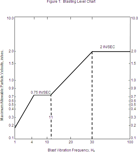
(iv) The department may require a seismograph record of any or all blasts and may specify the location at which the measurements are to be taken.
| 17.24.165 | MILLS AND REPROCESSING OPERATIONS: DEFINITIONS |
(1) "Alternate land use" means, with regard to a mill facility, reclamation of a site to an alternative postmining land use where the following conditions are met:
(a) The proposed postmilling land use is compatible with adjacent land use, and applicable landowner authorization.
(b) Retention of the structure is consistent with the proposed postmining land use. This shall be documented through inclusion of a schedule showing how the proposed use will be achieved within a reasonable time after milling and will be sustained.
(c) Plans for alternate land use must be integrated with the requirements of ARM 17.24.169 for the grading and revegetation of the surrounding area.
(d) Plans must document, if appropriate, that financing, attainment, and maintenance of the alternative land use is feasible.
(e) The proposed use will:
(i) not present actual or probable hazard to public health or safety;
(ii) comply with the air and water quality acts; and
(iii) minimize adverse effects on fish, wildlife, and related environmental values.
(2) "Contingency plan" means, with regard to spilled process solution, a plan which includes, but is not limited to, steps for containment, neutralization, and removal, and identification of any associated training needs.
(3) "Description of existing environment" means a description with appropriate maps of the condition of the proposed project area prior to exploration or operation. The description shall provide, but not be limited to, a discussion which characterizes each of the following:
(a) geology;
(b) soils;
(c) vegetation including, but not limited to, canopy cover, diversity, use, and productivity;
(d) wildlife;
(e) hydrology (surface and ground water characteristics, quantity, quality, and use) , including maps which identify springs, seeps, and wells within one mile of the permit boundary and three miles down gradient unless a lesser distance is justified and agreed to by the department;
(f) air quality and climate;
(g) aquatic biology;
(h) land use and ownership;
(i) recreation;
(j) cultural/historic resources identified as a result of inventory and of file searches conducted by the State Historic Preservation Office;
(k) noise;
(l) transportation;
(m) aesthetics.
(4) "Expansion of a mill facility" means disturbance of an area not previously disturbed by the milling operation, and, in the case of a waste dump, tailing impoundment, or similar facility, a change in the design capacity that will result in an increase in land disturbance at an existing mill facility. When disturbance of an area not previously disturbed by the operation occurs at a dump, impoundment or similar facility, the department may regulate the previously disturbed area to the extent necessary to achieve reclamation of the expansion area.
(5) "Facility" means any building, impoundment, embankment, waste or tailings disposal site, or other man-made structure associated with a particular activity. Mill facility means a mill and associated structures, disturbance and development.
(6) "Mill" means any facility for ore, tailings, or waste rock processing and disposal. This term does not include smelting, or refining facilities, sample collection processes, and pilot testing performed pursuant to an exploration license.
(7) "Plan" means that information submitted to the department pertaining to a proposed or ongoing milling related activity which utilized narratives, engineering designs, maps, cross-sections, or other documentation which adequately describes the activity.
(8) "Reclamation" means removal of facilities, unless an alternate land use is approved and the regrading, contouring, and revegetation of disturbed land. For the purpose of ARM 17.24.166 through 17.24.170, reclamation shall be deemed complete when the disturbed land is restored to a comparable utility and stability as that of adjacent areas, except for open pits and rock faces which may not be feasible to reclaim. Reclamation of previously disturbed areas is required only to the extent feasible given the pre-existing condition of the site.
(9) "Reclamation to the extent practicable and feasible" means, with regard to reprocessing of waste rock and tailings:
(a) where waste rock and tailings have previously been reclaimed under the Act and this subchapter, compliance with the standards set for an operating permit;
(b) where waste rock and tailings have not previously been subject to the reclamation requirements of the Act and this subchapter and are to be redisturbed under the proposed permit, the following:
(i) reclamation of any reprocessed waste rock and tails and associated facilities consistent with the standards of this definition;
(ii) salvage and replacement of available soil or suitable materials;
(iii) use of suitable materials at the surface of any reprocessed waste rock to the extent practicable;
(iv) grading of slopes to a stable angle, treating with appropriate soils amendments and vegetating with a perennial seed mix;
(v) amending and seeding the regraded site such that utility is improved over that which existed prior to reprocessing;
(vi) preservation of water quality at least to the level that existed prior to reprocessing.
| 17.24.166 | MILLS: APPLICABILITY OF RULES TO MILLS |
(2) For mills under permit on June 1, 1990 existing bond must be upgraded at the time of the next permit amendment, unless the department requires earlier upgrading or an operator chooses to update the mill permit information and bond prior to that time. Prior to updating information, the operator shall meet with the department to determine the appropriateness of the requirements in ARM 17.24.168 to the specific situation. Any requirement determined not applicable shall be documented in the permit with the reasons for the determination.
(3) Mills constructed as a part of a new mining operation must be permitted under the mine operating permit using the information required in ARM 17.24.167 through 17.24.170.
| 17.24.167 | MILLS: OPERATING PERMIT APPLICATION |
(2) Prior to receiving an operating permit, the applicant must:
(a) pay a $500 filing fee to the department unless the mill application is associated with and submitted concurrently with a new operating permit application submitted under 82-4-335 , MCA;
(b) indicate the proposed date for commencement of milling and the minerals to be milled and the conceptual life of the mill;
(c) provide a map or maps to scale of the mill area (such map must locate the proposed mill and must locate and identify streams, and proposed roads, railroads, and utility lines in the immediate area and residences and wells within one mile of the permit area) . All maps provided in the application must have a uniform base, a scale, and a north directional arrow;
(d) file a reclamation bond pursuant to 82-4-338 , MCA;
(e) file a plan of operation including construction, operating, monitoring and contingency plans; and
(f) file a reclamation plan.
(3) The department shall provide public notice of mill applications, consistent with 82-4-353 , MCA.
| 17.24.168 | MILLS: OPERATING PLANS |
(a) a description of the existing environment;
(b) a plan of operations that includes:
(i) all of the matters required by 82-4-335 (3) (d) through (k) , MCA, excepting the mine map;
(ii) maps enhancing narratives which use the same base and scale as required by ARM 17.24.167(2) (c) ; where appropriate;
(iii) a description of the design, construction, and operation of the mill, tailings, and waste rock disposal facilities;
(iv) a list of equipment and chemicals to be used in the operation by location and task;
(v) a description of all buildings and identification of mill design capacity;
(vi) a description of topsoil salvage and stockpiling activities;
(vii) a description of the general chemical processes and the purpose and amount and source of water used in the operation and the amount and disposition of any process wastewater or solutions to be disposed;
(viii) a description of the power needs and source(s) , including fuel storage sites;
(ix) sewage treatment and facilities and solid waste disposal sites;
(x) a description of the transportation network to be used or built during the construction and operation phases, and a listing of the type and amount of traffic at mill capacity;
(xi) a description of the fire protection plan and the toxic spill contingency plan and a certification that notice of the filing of the plan has been provided to the state fire marshal;
(xii) plans describing the design and operation of all diversions and impounding structures and sediment control. Descriptions shall be detailed enough to provide an accurate depiction of the safety, utility and stability of such structures;
(xiii) a discussion of predicted noise levels by activities during construction and operational phases;
(xiv) a discussion of the potential and known archaeological and cultural values in the area of potential environmental effect for the project and a discussion of how such values are to be given consideration;
(xv) provisions for the prevention of wind erosion of all disturbed areas;
(xvi) a description of the provisions for protection of off-site flora and fauna;
(xvii) plans for the monitoring of ground water and surface water until continuous compliance with water quality standards is demonstrated, and a contingency plan in case of accidental discharge describing remedial action in cases requiring emergency action;
(xviii) a plan for the protection of topsoil stockpiles from erosion and contamination; and
(xix) a listing of known sources and volumes of incoming ore, tailings, or waste rock.
(c) (i) anticipated employment including both direct and onsite contract employees;
(ii) if the mill is proposed to be operated in conjunction with a mine operated by applicant, personnel requirements by location and task for construction and operation phases. (Operations meeting the definition of "large scale mineral development" in 90-6-302 , MCA, must also comply with the Hard Rock Impact Act, Title 90, chapter 6, part 3, MCA) .
(2) Annual reports must be submitted consistent with 82-4-339 , MCA, and include in addition:
(a) sources and volumes of incoming ore;
(b) volumes of tailings or waste generated;
(c) water monitoring report;
(d) remaining waste and tails capacity.
(3) Plans submitted under ARM 17.24.167, 17.24.168, and 17.24.169, must be consistent with plans filed with other permitting authorities.
| 17.24.169 | MILLS: RECLAMATION PLANS |
(a) all of the requirements of a reclamation plan set forth in 82-4-303 (13) (a) and (d) through (h) , 82-4-336 , MCA, and ARM 17.24.115;
(b) a regarding plan which leaves all disturbed areas in a stable configuration and which conforms with the proposed subsequent use of the land after reclamation. The department may require the use of cross-sections, topographic maps or detailed narrative, or a combination of these, to ensure that the application adequately describes the proposed topography of the reclaimed land. All reclaimed slopes on materials potentially acid or toxic forming shall be graded to assure future erosion of acid and toxic forming materials offsite is prevented using prudent slope angle and length;
(c) a description of the manner in which the soil materials will be redistributed from the stockpiles to the area to be reclaimed (e.g., truck/loader, scrapers) , to provide for adequate revegetation;
(d) a description of the methods by which surface and ground water will be restored or maintained to meet the criteria of Title 75, chapters 5 and 6, MCA, as amended, or rules adopted pursuant to these laws, including methods used to monitor for accidental discharge of objectionable (potential toxic or acid-producing) materials, plans for detoxification or neutralization of such materials, and remedial action plans for control and mitigation of discharges to surface or ground water;
(e) a plan for the reestablishment of vegetation which conforms with the proposed subsequent use of the land after reclamation. Such revegetation plan must consider the following:
(i) The first objective in revegetation is to stabilize the area as quickly as possible after it has been disturbed. Plants that will give a quick, protective cover and those that will enrich the soil must be given priority. Plants reestablished must be in keeping with the intended reclaimed use of the land.
(ii) Appropriate revegetation must be accomplished as soon after necessary grading as possible; however, revegetation must be performed in the proper season in accordance with accepted agricultural and reforestation practices.
(iii) In the event that any of the above revegetation efforts are unsuccessful, the permittee shall seek the advice of the department and make additional attempts, incorporating such changes and additional procedures as may be expected to provide satisfactory revegetation;
(f) a schedule describing the manner and deadlines for the removal of facilities including, but not limited to, the removal of buildings or related structures, or a plan meeting the requirements for alternative land use.
(2) The department may require additional measures necessary to ensure that the disturbed area is reclaimed in accordance with the Act.
| 17.24.170 | MILLS: CESSATION OR COMPLETION OF OPERATION |
(1) Milling operations are presumed completed or ceased and thus are subject to the reclamation time schedule outlined in the approved reclamation plan when the mill has ceased operations for a period of two years or more. A permittee may rebut this assumption by providing evidence satisfactory to the department, consistent with ARM 17.24.150(2) , that the operations have not in fact been abandoned or completed.
(2) Reclamation plans must provide that all discharges from completed operations or operations in a state of temporary cessation will be consistent with provisions of ARM 17.24.151.
| 17.24.171 | REPROCESSING OF WASTE ROCK AND TAILINGS |
(2) A person who institutes a new reprocessing operation after May 31, 1990, who is not a small miner must obtain an operating permit before engaging reprocessing operations or disturbing land in anticipation of these operations.
(3) A person who wishes to continue a reprocessing operation that was conducted at any time during the 12 months immediately preceding the effective date of these rules must, in order to continue those operations no later than December 1, 1990, obtain an operating permit. Operations not conducted within the 12 months immediately preceding the effective date of this rule are considered new operations for the purposes of this rule.
| 17.24.180 | DEFINITIONS |
(1) "Commence reclamation within six months" means to commence reclamation within six months or the first seasonal opportunity after mining is not resumed after a seasonal closure;
(2) "Live stream" means a stream with flowing water;
(3) "Pay gravel" means gravels containing sufficient mineralization to be economic;
(4) "Plant" means a support facility, including a wash or processing plant, for a placer or dredge operation;
(5) "Sedimentation" means solid material settled from suspension in a liquid; mineral or organic solid material that is being transported or has been moved from its site of origin by air, water, or ice, and has come to rest on the earth's surface either above or below sea level; or inorganic or organic particles originating from weathering, chemical precipitation or biological activity.
| 17.24.181 | SMALL MINER PLACER AND DREDGE BONDING |
(1) A small miner who operates a placer or dredge mine shall post a $10,000 bond unless the department approves a lower amount based on the criteria outlined in (2) or unless it is documented that a bond for reclamation is posted with another government agency.
(a) Bond must be filed in the form of a surety, payable to the state of Montana or to the state and the appropriate federal agency, a cash deposit, an assignment of certificate of deposit, letter of credit, or other surety acceptable to the department.
(b) The bond must be accompanied by an appropriate map showing the location of the mine, anticipated disturbances, and perennial streams in the vicinity.
(c) A small miner placer or dredge mine operator that posted a bond with the department prior to May 15, 1997, for a mine is not required to post a bond in excess of $5,000 for that mine.
(2) The department shall reduce the required bonding amount if the small miner submits an operating plan documenting that the cost of reclamation to the department would be less than $10,000. The information needed to make such a determination includes the following:
(a) a description of the proposed mining operation and foreseeable expansion;
(b) a description of the mine support facilities;
(c) the type of equipment and capacity of the plant;
(d) an estimate of pit and pond sizes and volumes of all soil, overburden and placer gravel stockpiles;
(e) description of mining sequence and maximum acreage to be disturbed and unreclaimed at any one time at the mine being bonded;
(f) a description of any water diversions required by the operation;
(g) a topographic map locating mine pit, ponds, diversions, roads, process area, and stream drainages and materials storage sites. This map should include a reference to existing locatable monuments or landmarks on the ground;
(h) the depth of soil, overburden and pay zones to be excavated;
(i) the average and maximum rate of pay gravel removal;
(j) the length and width of roads and average size of the plant area;
(k) any proposal to use suitable settling pond sediments as soil amendment if limited soil is available;
(l) a proposed permanent seed mixture and rate of application (lbs/ac) ;
(m) characterization of stream channel and riparian conditions for locations where disturbance is proposed;
(n) identification of the construction method and materials to be used to reclaim soils, overburden, gravel stockpiles, and other disturbances and to reestablish functioning streams and associated floodplains where stream channels have been disturbed;
(o) an erosion control plan which contains the appropriate elements from ARM 17.24.182;
(p) whenever applicable, a description of the status of 404 permits issued pursuant to the federal Clean Water Act and plans of operation required by federal land management agencies; and
(q) status of 310 permit compliance, pursuant to 75-7-101, MCA, et seq., and status of Montana pollution discharge elimination permit compliance pursuant to 75-5-401, MCA, et seq.
| 17.24.182 | (INTERPRETIVE RULE) OPERATIONAL RECOMMENDATIONS FOR SMALL MINERS |
(a) Mining equipment should not be operated in a live stream or diversion, or in any manner to cause bank caving or erosion of the bank of any live stream or diversion.
(b) The amount of make-up water should be limited to only the amount required to operate the wash plant with spent water being recirculated back to the wash plant.
(c) Runoff from undisturbed areas should be minimized through use of temporary berms.
(d) Adequate temporary berms and/or natural undisturbed areas of vegetation should be placed or left as a buffer zone around diversion ditches and live streams to prevent water quality degradation and erosion of disturbed areas as a result of runoff from a ten-year, 24-hour precipitation event.
(e) During operations, care should be taken to protect streambanks and streambank vegetation, streambanks, ditches, and diversions should be lined, riprapped, or otherwise stabilized to prevent excess erosion.
(f) Roads should:
(i) be constructed to provide controlled drainage, include culverts, waterbars, and slash filters necessary to facilitate drainage and minimize erosion and be constructed to reduce concentrated flows;
(ii) be located on well-drained soils and located back from stream bottoms in order to provide a buffer zone for preventing road sediments from washing into stream channels;
(iii) be located outside slide-prone areas characterized by seeps, steep slopes, highly weathered bedrock, clay beds, concave slopes, hummocky topography, and rock layers that dip parallel to the slope;
(iv) be constructed to stabilize sloped exposed surfaces by seeding, compacting, riprapping, benching, mulching or other suitable means prior to fall or spring runoff;
(v) not be left in an erosive condition over a winter season; and
(vi) be used only minimally during wet periods and spring breakup when damage to the roads, which would result in increased sedimentation, is likely to occur.
(g) Cut-and-fill slopes should be constructed at a stable angle and stabilized by seeding, mulching, benching or other suitable means during the same season as construction.
(h) Clearing, grubbing or logging debris should not be placed in streams or used for diversions or cause water quality degradation.
(i) Diversions and impoundments should be sized to pass the ten-year, 24-hour precipitation event. Diversions should be constructed with drop structures or energy dissipators whenever necessary to prevent erosion. Diversion ditch berms should be sloped to account for site-specific conditions, including soils, climate, height of structure and existing natural slopes, and should be revegetated, riprapped, or otherwise stabilized to minimize stream sedimentation.
(j) Before winter shutdown, a small miner should take the following precautions:
(i) Diversions should be sized to pass spring runoff (minimum ten-year, 24-hour event) or streams should be returned to original channels.
(ii) Ponds should have adequate freeboard to prevent over-topping during spring runoff from direct precipitation and over-land flow. Whenever ponds are located within a flood plain and diversions are not sized to pass the ten-year, 24-hour precipitation event, ponds should be filled and reclaimed prior to onset of winter.
(iii) Soil, overburden, and tailings stockpiles should not be placed near streams, unless necessary, and, or if so placed, should be bermed at the toe to prevent erosion of sediments into streams.
(iv) Fuel storage tanks should be drained before winter shut down and should be drained and disposed of in a manner which protects adjacent streams.
(k) Dikes should be constructed around fuel storage areas to prevent a spill or discharge of fuel to any waters.
(2) A placer or dredge operator who proposes a "project", as that term is defined in 75-7-103 , MCA, on a perennial stream, must comply with the requirements of the Natural Streambed and Land Preservation Act, as amended, by obtaining a permit required by the appropriate conservation district.
(3) In order for a SMES placer or dredge operator to meet the reclamation requirements for bond release, the following reclamation planning guidelines should be followed:
(a) A reclamation plan, or appropriate waiver, for all roads is necessary.
(b) The postmine land use should be identified and a reclamation timetable should be established.
(c) Soil should be salvaged from all areas to be disturbed and should be stockpiled for use in reclamation.
(d) Site disturbances should be recontoured to a minimum of 3:1 slopes or flatter by backfilling excavated material, unless otherwise approved by the department as achieving comparable stability and utility in the postmining landscape.
(e) Soil and approved soil amendments should be redistributed over all areas disturbed by mining.
(f) The site should be seeded with perennial nonweedy species.
(g) Stream channels should be reconstructed, using coarse placer tails as necessary to dissipate energy. Riprap, temporary synthetic erosion control, or biodegradable revegetation fabrics in combination with permanent vegetation should be used to stabilize streambanks, as necessary. Streams should be reconstructed with grades, pools, and meanders comparable to premine drainage.
(h) Clays and fines available on-site should be used to create a relatively impermeable layer beneath reclaimed channels and floodplains.
(i) The floodplain should be returned to original contour with the gravel, overburden, and soils replaced to resemble their original stratigraphy.
| 17.24.183 | COMPARABLE UTILITY AND STABILITY OF RECLAIMED AREAS--STANDARDS FOR BOND RELEASE FOR SMALL MINERS |
(2) Bond may not be released unless the following reclamation standards for placer and dredging operations are achieved:
(a) Pits must be backfilled with overburden and washed gravels unless otherwise approved by the department as part of an alternate postmining land use that provides comparable stability and utility.
(b) Excess overburden must also have been appropriately placed and graded.
(c) Soils and soil substitutes must have been respread and graded on the backfilled, regraded overburden surface.
(d) Slopes must have been reduced to a grade which achieves comparable utility and stability in the postmining landscape.
(e) Disturbed areas must have been revegetated with appropriate perennial nonweedy species similar to that of adjacent areas.
(f) Roads must have been reclaimed to approximate original contour consistent with the postmining land form and land use in compliance with (1) unless otherwise approved by the department and concurred with by the landowner.
(g) Stream and floodplain disturbances must be reclaimed to their approximate premining condition so that comparable beneficial uses, such as fisheries, comparable flow capacity, and fluvial functions are restored. In most instances, this will require removal of berms.
(h) Noxious weeds must have been controlled, consistent with county weed board requirements.
| 17.24.184 | SMALL MINER BOND FORFEITURE AND SMES REVOCATION |
(1) If a small miner who conducts a placer or dredge operation fails to commence reclamation within six months after cessation of mining or within an extended period allowed by the department for good cause shown pursuant to (4) , or fails to diligently complete reclamation, the department shall notify the small miner by certified mail at the small miner's last reported address that bond will be forfeited and the department will reclaim the site unless the small miner commences reclamation within 30 days and diligently completes reclamation.
(2) The department shall revoke the small miner exclusion statement for any small miner whose bond is forfeited.
(3) Cessation of mining is considered to have occurred:
(a) whenever a small miner notifies the department of intent to cease operations; or
(b) whenever a site has been inactive through one operating season and the operator has failed to seek an extension for good cause shown.
(4) The department may grant an extension only when a site is temporarily stabilized in a manner which assures stability through spring runoff when impact to the environment will be minimized, and when public safety is ensured.
(5) Diligent completion of reclamation will be considered to have occurred whenever:
(a) a site has been graded and seeded in compliance with the requirements of ARM 17.24.183 during the first planting season, after cessation of activity; and
(b) reclamation standards are achieved within two years of completion of reclamation.
(6) An extension of time to reclaim must be renewed annually.
(7) A forfeited bond must be used as follows:
(a) Whenever reclamation can be achieved using the amount of the forfeited bond, excess funds must be returned to the small miner.
(b) Whenever the department documents in a written finding that reclamation cannot be achieved using the amount of the forfeited bond, funds may be deposited in the environmental rehabilitation and response account established by 82-4-311 , MCA, and reclamation must be conducted as priorities and additional funding allow. Forfeited funds deposited in the account may not be used for reclamation of other sites.
(c) Whenever reclamation costs exceed the bonded amount, the department may issue a notice to the placer or dredge operator that the excess costs are due and payable within 30 days, pursuant to 82-4-305 (6) , MCA. The department may bill the operator only for the cost of activities that are reasonably necessary to return the site to comparable stability and utility and to prevent pollution of state waters as defined in Title 75, chapter 5, MCA.
| 17.24.185 | SMALL MINER METAL LEACHING SOLVENT OR REAGENT APPLICATIONS |
(2) A small miner must obtain an operating permit for cyanide processing facilities and must meet requirements for these facilities imposed by statute and rule unless the facility is grandfathered pursuant to section 4 of Chapter 347, Laws of 1989.
(3) A small miner proposing to use metal leaching solvents or reagents other than cyanide in an ore processing facility must obtain a permit for those facilities pursuant to 82-4-335 (2) , MCA, for operations for which a valid small miner exclusion statement had not been obtained prior to May 1, 1999.
(4) To expedite permitting of cyanide or other metal leaching solvent or reagent facilities, the department shall make available to a small miner who has submitted or may submit an application for a permit to operate a cyanide or other metal leaching solvent or reagent ore processing facility appropriate department staff to determine how baseline, operating and reclamation plan requirements may be met in view of conditions and characteristics of the site at which the facility is proposed. The department shall process these permit applications as expeditiously as possible consistent with statutory deadlines for other permit applications and the department's obligations under the Montana Environmental Policy Act.
(5) An application for a small miner cyanide or other metal leaching solvent or reagent ore processing operating permit must contain:
(a) baseline information meeting the requirements of ARM 17.24.186;
(b) an operating plan meeting the requirements of ARM 17.24.187; and
(c) a reclamation plan meeting the requirements of ARM 17.24.188.
| 17.24.186 | SMALL MINER METAL LEACHING SOLVENT OR REAGENT BASELINE INFORMATION |
(a) a map showing all wells and springs and surface water that may be impacted by the proposal within one mile of the proposed permit area;
(b) a map showing all known significant cultural resources in the proposed permit area;
(c) analysis of surface and ground water samples for background parameters determined by the department, from selected sites chosen in consultation with department staff;
(d) a map delineating soil units for the proposed permit area based on available information, including that available from the soil conservation district;
(e) a listing of species of game fish within one mile of the proposed permit area;
(f) identification of any hatcheries in the vicinity of the proposed permit area;
(g) baseline precipitation records;
(h) flow data for surface and ground water identified in (a) and (c) above from available sources and water depth for identified wells; and
(i) identification of public water supply systems that withdraw water within five miles downstream from the ore processing facility.
| 17.24.187 | SMALL MINER METAL LEACHING SOLVENT OR REAGENT OPERATING PLANS |
(a) appropriate maps showing the location of the mine and support facilities, cyanide or other metal leaching solvent or reagent-processing facilities, permit boundaries, and perennial streams;
(b) the average and maximum tonnage/day and per year of ore to be processed and the amount of tailings to be generated;
(c) a narrative description of the precious metal recovery process;
(d) number, size and location of any proposed leach pads and ponds, and ore and tailings piles associated with processing;
(e) leach pad, pond, and waste facility designs;
(f) a plan for a leak detection system, including a program and schedule of monitoring for possible leakage which monitors pH, electrical conductivity (EC) , cyanide as weak acid dissociable (WAD) , other metal leaching solvents or reagents as appropriate, and other constituent levels, for those constituents appropriate to the type of processing proposed;
(g) a remedial action plan for controlling and mitigating discharges to surface waters;
(h) a description of the amount of make-up water required to operate the plant for ore processing;
(i) a plan for disposal of debris generated by clearing, grubbing and logging ensuring that the debris does not impact water quality or water flow;
(j) sediment and erosion controls for surface disturbances related to cyanide processing facilities;
(k) a road design and construction plan that provides controlled drainage, including location and number of culverts, waterbars, and slash filters;
(l) design for and map of adequate berms for placement around diversion ditches and live streams to prevent water quality degeneration and erosion of disturbed areas;
(m) a plan for stabilization of disturbed stream banks to assure that they will not be left in an erosive condition;
(n) a plan to salvage and stockpile soil from all areas to be disturbed by cyanide processing facilities, including stockpiles and wastepiles;
(o) design and construction plans for diversions and sediment impoundments to pass the ten-year, 24-hour precipitation event. A diversion must be constructed with drop structures, or energy dissipators if necessary to prevent erosion. Diversion ditch berms must be sloped to account for site-specific conditions, including soils, climate, height of structure, and existing natural slopes and must be revegetated, riprapped, or otherwise stabilized to prevent stream sedimentation;
(p) a plan for disposal of liquid and solid wastes which includes identification and application areas and the necessary discharge permits;
(q) end-of-season procedures for shutdown of the cyanide processing facility;
(r) a plan for prevention of damage to or for documentation of any significant historic, cultural, archeological and paleontologic feature within the permit areas on state and federal lands;
(s) identification and preliminary evaluation of reasonably feasible alternative facility sites;
(t) a commitment to comply with the operational requirements of this rule;
(u) a map of monitoring site locations which also identifies well depth;
(v) well logs for those wells identified in (u) above; and
(w) a commitment to avoid perennial streams wherever possible; and
(x) for facilities that are exposed to precipitation flows and that carry cyanidated or other metal leaching solvent or reagent solution, a plan that provides for adequate passage of a 50-year 24-hour storm even flow; and
(y) a plan for preventing wildlife access to facilities with cyanidated or other metal leaching solvent or reagent solutions.
| 17.24.188 | SMALL MINER METAL LEACHING SOLVENT OR REAGENT RECLAMATION PLANS |
(a) the postmine land use;
(b) a reclamation timetable;
(c) the proposed method for handling spent ore and disposal of any heavy metal sludge remaining in ponds;
(d) a plan for monitoring water balance for the ore processing facility;
(e) a neutralization plan for tailing and solutions;
(f) a map showing regrading plans for all cyanide or other metal leaching solvent or reagent-processing and related facilities to a stable, minimally erosive slope configuration by backfilling excavated material, consistent with the postmining land use;
(g) a narrative providing for reclamation of all buildings and structures;
(h) a plan for reclaiming all associated roads, or an appropriate waiver from the surface owner;
(i) a revegetation plan including seed mixes, method of seeding and rate of seed application (lbs/ac) ;
(j) a description of any permanent diversion or stream channel reconstruction process, including use of coarse noncyanidated, nonmineralized tails or borrow material to dissipate energy or riprap streams, or use of synthetic erosion control and revegetation fabrics. Streams must be reconstructed with comparable grades, pools, and meanders to premine drainage;
(k) a plan for stream channel reconstruction providing that the channel may not be reconstructed through reclaimed tails; and addressing control of drainage from the tails and the adjacent areas to maximize the long-term stability of the tails; and
(l) monitoring plans for reclaimed sites.
(2) In addition, a processing facility which would constitute a "project", as that term is defined in 75-7-103 , MCA, on a perennial stream, must comply with the requirements of the Natural Streambed and Land Preservation Act, as amended, by obtaining permits required by the appropriate conservation district.
| 17.24.189 | SMALL MINER METAL LEACHING SOLVENT OR REAGENT PROCESSING FACILITIES PERFORMANCE STANDARDS AND BONDING |
(1) The small miner shall notify the department of completion dates for each of the following phases of construction, and the department shall inspect and file a report on each of these phases:
(a) foundation preparation;
(b) compaction testing;
(c) liner placement;
(d) installation of leakage detection control systems; and
(e) installation of monitoring wells.
(2) In addition to the applicable performance standards of ARM 17.24.188 and 17.24.101, and 82-4-305 , MCA, the following are required prior to bond release:
(a) neutralization of cyanide or other metal leaching solvent or reagent-containing tailing and solutions to those levels considered acceptable under applicable water quality standards;
(b) submittal of construction reports for tailings, ponds, and other appropriate facilities related to cyanide or other metal leaching solvent or reagent processing, on a monthly basis;
(c) submittal of as-built designs for those facilities identified under ARM 17.24.187(1) (e) , (k) , (l) and (o) , within one month of completion of construction activities.
(3) Bonding for cyanide or other metal leaching solvent or reagent-processing facilities must cover the actual cost of reclamation to the department and the additional estimated cost to the department which may arise from management, operation, and maintenance of the site upon temporary or permanent insolvency or abandonment, until full bond liquidation can be effected. Bonds must be reviewed and, if necessary, adjusted at least once every five years, tied to either the rate of inflation based on the consumer price index, a change in activities, or both, as appropriate.
(4) Bond must be filed in the form of a surety, payable to the state of Montana or to the state and the appropriate federal agency, a cash deposit, an assignment of certificate of deposit, letter of credit, or other surety acceptable to the department.
| 17.24.201 | APPLICABILITY |
(1) This subchapter applies to opencut operations as provided in the Opencut Mining Act (Title 82, chapter 4, part 4, MCA, hereinafter referred to as "the Act").
(2) An operator conducting opencut operations must comply with the provisions of a contract or permit issued under the Act and this subchapter. Except as provided in (5) and (6), a permit is required before an operator conducts opencut operations.
(3) Contracts and permits in effect before September 27, 2022, need not be amended to comply with rules and rule amendments adopted on September 27, 2022. Applications for permits, permit amendments, and permit assignments that the department determined to be complete prior to September 27, 2022, remain subject to provisions of this subchapter relating to application requirements as they read on the date the department determined the application to be complete.
(4) Except as provided in (5) and ARM 17.24.226, a permit amendment is required before taking an action that expands or changes a permitted opencut operation.
(5) Except as provided in ARM 17.24.226(5), an operator holding a permit issued under the Act may commence a limited opencut operation that meets the criteria in ARM 17.24.226 and 82-4-431, MCA, after the operator has submitted a complete limited opencut operation form to the department.
(6) As provided by 82-4-431(3), MCA, a landowner may remove up to 10,000 cubic yards of opencut materials on the landowner's real property for personal or agricultural uses without obtaining a permit unless a removal affects surface water, including intermittent or perennial streams, ground water, or water conveyance facilities. Opencut materials must not be transported outside the borders of the property from which they are mined or adjoining property owned by the same individual or entity.
| 17.24.202 | DEFINITIONS |
When used in this subchapter, unless a different meaning clearly appears from the context, the following definitions apply:
(1) "Access road" means an existing or proposed non-public road that connects an opencut operation to a public road or highway. The term includes the roadbed, cut and fill slopes, ditches, and other structures and disturbances related to the construction, use, and reclamation of the access road.
(2) "Bonded area" means a portion of the permit area that is subject to a reclamation bond or other security approved by the department under this subchapter.
(3) "Clean fill" means soil, overburden, fines, dirt, sand, gravel, rocks, and rebar-free concrete that have not been made impure by contact, commingling, or consolidation with organic compounds such as petroleum hydrocarbons, inorganic metals, or contaminants that meet the definition of hazardous waste under ARM Title 17, chapter 53, or regulated PCB (polychlorinated biphenyls). "Rebar-free concrete" means pieces of concrete that may contain rebar, but from which no rebar protrudes beyond the concrete.
(4) "Department" means the Department of Environmental Quality provided for in 2-15-3501, MCA.
(5) "Dryland permit" means a permit required under 82-4-432(1)(c), MCA and subject to 82-4-432(14), MCA.
(6) "Intermittent stream" means a stream or reach of a stream that is below the local water table for at least some part of the year and obtains its flow from both ground water discharge and surface runoff.
(7) "Materials" has the meaning given in 82-4-403, MCA.
(8) "Non-bonded area" means the portion of a permit area that is not covered by a reclamation bond or other security approved by the department under this subchapter.
(9) "Occupied dwelling unit" has the meaning given in 82-4-403, MCA.
(10) "Opencut operation" has the meaning given in 82-4-403, MCA.
(11) "Overburden" has the meaning given in 82-4-403, MCA.
(12) "Pattern of violations" means three or more violations of the Act or this subchapter that harm or have the potential to harm human health or the environment. A violation does not contribute to a pattern of violations:
(a) until such time as the opportunity for administrative review, judicial review, or appeal have passed for the violation; or
(b) after the violator demonstrates compliance with all the terms of an administrative or judicial order in an action taken by the department under authority of the Act and this subchapter because of the violation.
(13) "Perennial stream" means a stream or part of a stream that flows continuously during all of the calendar year as a result of ground water discharge or surface runoff.
(14) "Permit area" means the areas subject to a permit granted under this subchapter.
(15) "Removal" means excavation of soil, overburden, and material from its natural condition.
(16) "Slope" means the measure of an incline by means of a ratio of horizontal to vertical distance indicated by a pair of numbers separated by a colon, for example, 3:1, which means one foot of rise over three horizontal feet.
(17) "Soil" has the meaning given in 82-4-403, MCA.
(18) "Standard permit" is a permit that is required under 82-4-432(1)(b), MCA and that is subject to 82-4-432(2) through (13), MCA.
(19) "Tilling" means breaking up the substrate or soil before seeding to a depth of at least one foot to improve conditions for plant growth.
| 17.24.203 | BOND OR OTHER SECURITY |
(1) An application for a permit by a non-government operator must be accompanied by a bond or other security acceptable to the department under 82-4-433, MCA, and this subchapter.�
(2) The department may adjust the amount of the bond or other security levels:
(a) based on information available to the department; and
(b) yearly when necessary to secure the department's estimate of costs to reclaim the affected land. Should the department determine that additional bond or other security is required, the operator shall submit a bond or security in the increased amount within 30 days of notification by the department.
(3) The operator shall immediately notify the department if the bond or other security is canceled or becomes ineffective. If the bond or other security is canceled or becomes ineffective, the operator shall reinstate or replace the canceled or ineffective bond or security with another bond or security acceptable to the department under 82-4-433, MCA, and this subchapter, within 30 days of notification by the department that the canceled or ineffective bond or other security must be replaced. In the event that the operator fails to reinstate or replace such bond or other security within the time provided in this rule, the department may suspend any permit secured by the canceled or ineffective bond or other security in accordance with 82-4-442, MCA. The operator shall immediately cease opencut operations, except reclamation activities, on lands covered by a suspended permit.
(4) An operator may apply for release of the bond in phases as follows:
(a) upon completion of phase I reclamation, which includes completion of all the requirements in ARM 17.24.219(1), except the requirements of ARM 17.24.219(1)(h)(ii)(K), (L), and (M). Any phase I reclamation bond or security release must leave sufficient bond or security to secure the estimated cost of completion of phase II reclamation;
(b) upon completion of phase II reclamation, which includes completion of all the requirements of ARM 17.24.219(1).
(5) An application for phase I or phase II bond release or release of other security must be submitted on forms provided by the department, and must include:
(a) a site map that shows:
(i) the existing permit area and release request area;
(ii) the landowner material stockpile area and remaining soil stockpile, if applicable;
(iii) roads; and
(iv) other pertinent mapping items as required by ARM 17.24.221(5);
(b) at least four photographs taken from the north, south, west, and east corners of the release request area; and
(c) for applications for release of bond amounts for phase II reclamation, at least three photographs taken at three different locations in the permit area showing typical vegetation within an area approximately five feet wide and including an object to define scale.�
(6) The department may release a portion of the bond or security when the operator demonstrates completion of a reclamation phase, as defined in (4), for a discrete portion of the permit area if:
(a) the remaining reclamation can be accomplished without disturbance of completed reclamation; and
(b) the remaining amount of bond or security is sufficient to cover estimated cost to complete reclamation of the affected land.
(7) Release of a portion of the bond or security after completion of phase I reclamation does not relieve the operator from responsibility for any reclamation or any increased costs of reclamation necessary to comply with the Act, this subchapter, and the permit until phase II bond release.
(8) State and federal agencies and counties, cities, and towns are not required to post a bond or security. These government operators may request release from responsibility for reclamation in the same manner as nongovernmental operators request bond or security release in accordance with this rule, including release of a portion of the permitted area, except that government operators may not request release of responsibility for phase I reclamation.
| 17.24.204 | SITE INFORMATION |
This rule has been repealed.
| 17.24.205 | MINING AND RECLAMATION PLAN |
This rule has been repealed.
| 17.24.206 | LANDOWNER CONSULTATION |
(1) An application for a permit or for an amendment to add acreage, for an asphalt or concrete plant, to change postmining land use, or to extend the reclamation date must demonstrate that the applicant consulted with the landowner about the proposed opencut operations by supplying a form provided by the department.
(2) The landowner consultation form must require the landowner to:
(a) acknowledge receipt of a copy of the application for a permit or amendment submitted to the department;
(b) affirm ownership of the property that is described in the application;
(c) affirm that the operator consulted with the landowner about the opencut operations described in the application;
(d) indicate whether access roads, haul roads, or other roads used in opencut operations are on affected land and are subject to the reclamation requirements of this subchapter;
(e) acknowledge the exclusive right of the operator, its agent, or assignee to conduct opencut operations on the property that is identified in the application; and
(f) acknowledge and consent to entry and enforcement of the Act and this subchapter by the department on all landowner property affected by opencut operations.
(3) The landowner consultation form also must require the operator and the landowner to consent to entry at reasonable times by the department and its employees, agents, or contractors to inspect the property and complete reclamation of all affected lands in accordance with the permit and the plan of operation in the event that the operator fails to do so.
| 17.24.207 | ADDITIONAL REQUIREMENTS FOR BENTONITE MINES |
(1) In addition to the requirements imposed by ARM 17.24.203, 17.24.206, and 17.24.218 through 17.24.222, the department may require the following information as part of the plan of operation for a bentonite mining operation:
(a) an analysis of the soil and each major stratum in the overburden that includes determinations of:
(i) saturation percentage;
(ii) pH;
(iii) electrical conductivity;
(iv) sodium adsorption ratio;
(v) texture; and
(vi) additional characteristics the department may require.
(2) A soil analysis required under (1)(a) must describe:
(a) the identifying number and depth of each sample taken;
(b) the methods by which the samples were taken;
(c) the names and addresses of the persons who took the samples;
(d) the analytical methods used; and
(e) the names and addresses of the persons who analyzed the samples.
(3) A soil analysis required by (1)(a) must be accompanied by a map that describes:
(a) the soil types identified;
(b) the location and depth of each sample taken;
(c) thicknesses of soil and overburden to be stripped for each soil type; and
(d) the dominant vegetative species present on each soil type.
(4) The department may also require that the plan of operation contain a description of the location and method of disposal of bentonite cleanings, stray bentonite seams, and overburden that are unsuitable for plant growth. Such materials must be buried under at least three feet of material suitable for sustaining the postmining vegetation, but if suitable burial material is not available, then the material that is unsuitable for plant growth must be laid and graded to a condition that is as good or better than the pre-mine condition, minimizes adverse impacts to plant growth, and blends into the surrounding area.
| 17.24.208 | ADDITIONAL REQUIREMENTS FOR SOIL MINES |
(1) In addition to the requirements imposed by ARM 17.24.203, 17.24.206, and 17.24.218 through 17.24.222, the operator must submit, as part of the application for soil mining, soil and overburden characterization and handling sections as specified in ARM 17.24.218(1)(c) and (d).
(2) The operator must salvage the top 24 inches of soil for reclamation, or if the operator intends to mine any portion of the top 24 inches of soil, the operator must provide testing and analysis demonstrating that a minimum of 24 inches of growth media remains and that it is capable of supporting the proposed postmining land use. Required analysis of the remaining 24 inches of soil and overburden must include:
(a) pH;
(b) electrical conductivity;
(c) sodium adsorption ratio;
(d) percent sand, silt, clay, and rock; and
(e) additional characteristics the department may require.
(3) A soil analysis required under (2) must describe:
(a) the identifying number and depth of each sample taken;
(b) the methods by which the samples were taken;
(c) the names and addresses of the persons who took the samples;
(d) the analytical methods used; and
(e) the names and addresses of the persons who analyzed the samples.
(4) A soil analysis required by (2) must be accompanied by a map that describes:
(a) the soil types identified in the top 24 inches removed from the site;
(b) the soil types identified in the 24 inches to remain for reclamation;
(c) the location and depth of each sample taken;
(d) thicknesses of soil and overburden to be stripped for each soil type; and
(e) the dominant vegetative species present on each soil type.
(5) A soil analysis required under (2) must include within the application the above sampling information and a detailed summary that demonstrates the remaining soil can meet the proposed postmining land use.
| 17.24.212 | REVIEW OF AN APPLICATION |
(1) Upon receipt of an application to conduct opencut operations and within the time limits provided in 82-4-432, MCA, the department shall evaluate the application to determine if the requirements of the Act and this subchapter are satisfied.
(2) Except as provided in 75-1-208(4)(b), MCA, within five working days of receipt of an application to conduct opencut operations, the department shall determine and notify the applicant whether the application is complete. A complete application must be submitted on forms provided by the department, or alternative forms approved by the department prior to submission, and must contain the materials and information required by 82-4-432(1) and (2), MCA, and the plan of operation required by ARM 17.24.218 through 17.24.223.
(3) If the department determines that an application is complete, the applicant shall comply with the public notice requirements required by 82-4-432, MCA, and the department shall review the application for acceptability.
(4) A permit application is acceptable if the materials and information provided to the department demonstrate that the proposed opencut operation complies with requirements of 82-4-432(1) and (2), MCA. An application for a standard permit must contain a plan of operation that meets the requirements of this subchapter.
(5) A permit must provide that the operator shall comply with the requirements of the Act and this subchapter. Before determining that an application for a permit or amendment is acceptable, the department may condition a permit as necessary to accomplish the requirements of the Act and this subchapter.
(6) A permit becomes effective when the department notifies the applicant in writing that the information and materials provided to the department meet all the requirements of the Act and this subchapter and that the permit is approved and issued by the department.
| 17.24.213 | AMENDMENT OF PERMITS |
(1) An operator may apply for an amendment to its permit by submitting an application on a form provided by the department. Upon receipt of an amendment application and within the time limits provided in 82-4-432, MCA, the department shall evaluate the amendment application to determine if the requirements of the Act and this subchapter will be satisfied.
(2) An application to amend a permit is acceptable if it meets the requirements of ARM 17.24.212 and includes the following:
(a) a new or additional bond or other security sufficient to cover additional estimated costs of reclamation required by ARM 17.24.203 and 17.24.220;
(b) a new landowner consultation form if required under ARM 17.24.206;
(c) a new zoning compliance form if required under ARM 17.24.223; and
(d) if the application to amend is for a standard permit, a revised plan of operation.
(3) An amendment becomes effective when the department notifies the applicant in writing that the information and materials provided to the department meet all the requirements of the Act and this subchapter and that the amendment is approved and issued by the department. Once approved, an amendment becomes part of the original permit.
| 17.24.214 | ANNUAL PRODUCTION REPORT |
(1) An operator shall submit one annual production report that addresses all opencut operations during the previous calendar year to the department on or before March 1 of each year.
(2) The annual production report must be submitted electronically or on a form provided by the department. The report must list all sites where the operator engaged in permitted, unpermitted, or limited opencut operations and describe the amount of materials removed for each site.
(3) The annual production report must be accompanied by payment of the annual fee, in accordance with 82-4-437, MCA. The federal government, state of Montana, counties, cities, and towns are exempt from annual fees.
(4) The department may require an operator to provide documentation of materials removed for the purpose of verifying the amounts reported under this rule.
| 17.24.215 | PENALTIES |
This rule has been repealed.
| 17.24.216 | GENERAL APPLICATION CONTENT AND PROCEDURES |
This rule has been repealed.
| 17.24.217 | PLAN OF OPERATION--PREMINE INFORMATION |
This rule has been repealed.
| 17.24.218 | PLAN OF OPERATION (SITE CHARACTERIZATION, SITE PREPARATION, SOIL AND OVERBURDEN HANDLING, MINING, AND PROCESSING PLANS) AND PERFORMANCE STANDARDS |
(1) An application for a standard permit or standard permit amendment requires a plan of operation that complies with 82-4-432, MCA and includes the following:
(a) unless otherwise approved in writing by the department, a markers section that includes a statement that the operator clearly marked on the ground all required boundaries and permitted access roads to be improved or constructed and will maintain the markings as required by this rule. Boundary and road markers must be placed so that no less than two consecutive markers are readily visible in any direction from any point on a line. The following requirements apply to marking boundaries and permitted access roads to be improved or constructed:
(i) markers must be in place prior to submitting an application for a permit or an amendment;
(ii) markers should be durable stout steel, wood, or similar quality posts and painted or flagged to be readily visible, except that a prominent, permanent feature such as a pole, tree, or large rock, flagged or painted, may serve as a marker;
(iii) road markers may be removed as the road is constructed, but each boundary marker must be maintained in place and readily visible until the adjacent permit area is reclaimed and released;
(iv) the following areas and features must be marked according to this rule:
(A) proposed permit or proposed amended permit boundaries;
(B) non-bonded areas;
(C) proposed permitted access roads to be improved or constructed;
(D) phase 1 release areas previously approved by the department; and
(E) prior to submission of an application for bond release, areas that are the subject of an application for phase I or phase II bond release;
(v) the requirements of (1)(a) do not apply to active hayland, cropland, or existing roads to be permitted;
(b) an access road construction and use section that is consistent with the landowner's acknowledgements contained in the landowner consultation form required by ARM 17.24.206;
(c) a soil and overburden characterization section that includes the average soil and overburden thicknesses in the permit area determined on the basis of no less than three test holes spaced representatively to describe proposed permit areas of less than nine acres and one test hole per each three-acre area for proposed permit areas of nine acres or more, with a maximum of 20 representatively spaced test holes for proposed permit areas that exceed 60 acres, or as otherwise approved by the department in the permit;
(i) for the purposes of this subsection:
(A) test holes must be of sufficient depth to measure the thicknesses of soil and overburden;
(B) representative test holes must be located in both bonded and non-bonded areas;
(C) exposures of the soil and overburden profile, such as a roadcut, may be used in lieu of a test hole; and
(D) clearly labeled photos showing the top three feet of the soil profile with a visible scale must be taken and provided to the department for each test hole;
(d) a soil and overburden handling section that includes a statement that the operator shall:
(i) upon commencing opencut operations, strip and stockpile overlying soil to the depth specified in the permit before excavating overburden and materials;
(ii) before mining, remove and stockpile overburden separately from soil and designate soil and overburden stockpiles with signage that is legible, readily visible, and placed so that equipment operators and inspectors may readily identify the type of stockpile for the life of the stockpile;
(iii) never stockpile overburden or soil on slopes greater than 3:1 or in drainages or in a manner that will cause pollution to state waters;
(iv) remove all soil and overburden from a minimum ten-foot-wide strip along the crest of a highwall;
(v) haul soil and overburden directly to areas prepared for backfill and grading or resoiling or to separate stockpiles;
(vi) never stockpile overburden or conduct any opencut operations on areas where soil has not been stripped to the depth required by the permit; and
(vii) use best management practices to prevent erosion, commingling, contamination, compaction, and unnecessary disturbance of soil and overburden stockpiles including, but not limited to, at the first seasonal opportunity, shape and seed, with approved perennial species, the soil and overburden stockpiles that are capable of sustaining plant growth, and that remain in place for more than two years and maintain the accessibility of all overburden and soil stockpiles in the permit area prior to reclamation in accordance with the plan of operation;
(viii) where required by 82-4-434, MCA, berms constructed of soil and/or overburden, must be a minimum of 6 feet high, protected from erosion, commingling, contamination, compaction, and unnecessary disturbance. At the first seasonal opportunity, the operator must shape and seed, with weed-free seed mix, any berm capable of sustaining plant growth;
(e) a construction, mining, processing, and hauling section that includes:
(i) a description of the materials to be sold or used by the operation;
(ii) a construction project plan that describes the locations and construction schedules for all areas to be disturbed and location of all facilities including offices, parking, vehicle staging areas, roads designated by the landowner as affected land, and processing plants;
(iii) a description of the methods and equipment to be used to mine, haul, and process material;
(iv) a description of the anticipated general mining progression, including the location of the first stripping and excavation, the direction of mining progress, and timing for the mobilization and setup of processing facilities such as a screen, crusher, asphalt plant, wash plant, batch plant, pug mill, and other facilities; and
(v) other information necessary to fully describe the nature and progress of opencut operations;
(f) a water resources section that includes:
(i) identification of the sources of the information reported, such as landowners, field observations, and water well logs;
(ii) the estimated seasonal high and seasonal low water table levels in the permit area and the information sources used, such as landowners, field observations, nearby surface water, and water well logs.
(g) a statement by the operator that:
(i) opencut operations may not occur within prohibited areas described in the permit;
(ii) no opencut operations will occur within an easement unless written permission to do so is obtained from the holder of the dominant estate; and
(iii) before commencing opencut operations, the operator, on a form provided by the department, notified the weed board in the county or counties in which the proposed operation is located. A copy of the form that the applicant submitted to the weed board must be attached to the application;
(h) an additional commitments section that includes a statement that the operator will:
(i) inform key personnel and subcontractors involved in opencut operations of the requirements of the plan of operation;
(ii) promptly notify the state historic preservation office archaeological or historical values are found.
(2) An application for a dryland permit or to amend a dryland permit does not require submission of a plan of operation.
(3) Approval of an application does not relieve the operator from the requirements of any applicable federal, state, county, or local statute, regulation, rule, or ordinance, including requirements to obtain any other permit, license, approval, or permission necessary for the actions described in or required by the application and the permit.
(4) Upon issuance of the permit, the operator shall comply with all commitments required by this rule and with the requirements for the conduct of operations contained in this rule.
| 17.24.219 | PLAN OF OPERATION, RECLAMATION PLAN, AND PERFORMANCE STANDARDS |
(1) An application for a dryland permit or to amend a dryland permit does not require a plan of operation. An application for a standard permit or to amend a standard permit must include a plan of operation that complies with 82-4-434, MCA and the following:
(a) a postmining land uses section that includes a description of the type, location, and size of each postmining land use area in the permit area. Postmining land use types include, but are not limited to, internal roads, material stockpile areas, pond, wetland, riparian area, grassland, rangeland, shrubland, woodland, pasture, hayland, cropland, wildlife habitat, recreation site, and residential, commercial, and industrial building sites;
(b) a surface cleanup section that includes a statement that the operator will:
(i) at the conclusion of opencut operations, except as provided in (1)(b)(ii), use or haul away from the permit area all excavated or processed material for backfill as provided in (1)(c);
(ii) upon the request by the landowner, on the landowner consultation form, segregate specific types, grades, and quantities of material into stockpiles maintained in one location, along with a separate stockpile of the quantity of soil required to reclaim the area where the material is stockpiled, shaped, and seeded and placed within 100 feet of a material stockpile;
(iii) a stockpile of materials for the landowner as provided by (1)(b)(ii) must be free of excess fines or other waste materials that would render the material unsuitable for commercial use;
(iv) provide a description of the types, grades, and quantities of material proposed to remain stockpiled as provided by (1)(b)(ii) and (iii), and justify the quantities stockpiled for landowner use based on current and expected demand for the materials;
(v) at the conclusion of opencut operations, haul away and properly dispose of all refuse, oiled surfacing, contaminated materials, concrete that is not clean-fill, and unused clean fill from affected lands;
(vi) haul away all asphaltic pavement from the permit area, except on-site-generated asphaltic pavement may be used as mined-area backfill in accordance with (1)(b)(vii) and with the consent of the landowner;
(vii) place on-site-generated asphaltic pavement, coarse clean fill, and other clean fill unsuitable for plant growth under at least three feet of material suitable for sustaining the postmining vegetation;
(viii) place on-site-generated asphaltic pavement in an unsaturated condition at least 25 feet above the seasonal high water table; and
(ix) for the purposes of (1)(b)(ii) and (iii), the operator remains responsible for reclamation of the areas occupied and affected by material and soil stockpiles until the department has approved phase II reclamation for the areas where the stockpiles are located or assignment of the permit to the landowner or another party;
(c) a backfill and grading section that includes a statement that the operator will:
(i) use only overburden and materials from the permit area, or otherwise only clean fill from any source, to reclaim affected land to a stable condition with 5:1 or flatter slopes for hayland and cropland, 4:1 or flatter slopes for sandy surfaces, and 3:1 or flatter slopes for other sites and surfaces appropriate to the designated postmine land use;
(ii) reclaim premine drainage systems to blend into the surrounding topography and drainages;
(iii) drain off-site or concentrate water in low areas identified in the permit;
(iv) backfill and grade to at least three feet above the seasonal high water table level for dryland reclamation and at approved depths below the seasonal low water table level for pond reclamation;
(v) record the average thickness of overburden replaced and never cover soil with overburden;
(vi) if available, up to 24 inches of soil and overburden must be stripped, salvaged, and replaced for reclamation. If overburden is a mine material or will be used as binder, an appropriate quantity must first be stripped and salvaged to satisfy the soil plus overburden replacement thickness requirement (24 inches cumulative);
(vii) for the purposes of (1)(c)(i) and (ii), the department may consider steeper slopes for certain postmining land uses based on a design or a slope stability analysis prepared by a professional engineer licensed in accordance with Title 37, chapter 67, part 3, MCA, or a geologist with five years of post-graduate academic or professional work experience in the field of soil or rock mechanics;
(viii) if required by the department, conduct postmining monitoring of ground water levels to ensure that appropriate reclaimed surface elevations are established;
(d) a description of the locations and designs for any special reclamation features such as ponds, waterways with defined channels, and building sites. Reclaimed waterways with defined channels must be located in their approximate premine locations and have channel and floodplain dimensions and gradients that approximate premine conditions, unless otherwise approved by the department. Reclaimed waterways with defined channels must connect to undisturbed waterways in a manner that avoids disruption or accelerated erosion of the reclaimed waterway or adjoining areas;
(e) an access road reclamation section describing:
(i) reclamation of access, haulage, or other roads included on affected land with the landowner's consent; and
(ii) for private roads to remain open at the request of the landowner, reclamation of the road to a width appropriate to the landowner's anticipated use or as may otherwise be required by applicable land use regulations;
(f) a section that explains how the operator will reclaim water diversion, retention, discharge, and outflow structures constructed for opencut operations;
(g) an overburden and soil conditioning section that includes a statement that the operator will:
(i) till replaced overburden, graded surfaces, and other compacted surfaces:
(A) to a depth of at least 12 inches, or to another depth required by the department prior to replacing soil, except that:
(I) tillage is not required for relatively non-compactible materials such as sands, materials with a rock fragment content of 35 percent or more by volume, or bedrock; and
(II) tilling deeper than the soil thickness is not required when cobbly material or bedrock underlies the soil;
(B) on the contour and when the overburden and soil are dry enough to shatter; and
(C) in a manner that protects tilled areas from recompaction;
(ii) record the thicknesses of soil replaced on the permit areas as required by the permit;
(iii) till through replaced soil and into the surface of the underlying backfill prior to seeding or planting unless otherwise required by the department; and
(iv) the soil surface must be free of rocks that are not characteristic of the soil prior to disturbance;
(h) a revegetation section that:
(i) describes the types and rates of fertilizer and other soil amendment applications, methods of seedbed preparation, and methods, species, and rates of seeding or planting; and
(ii) includes a statement that the operator will:
(A) establish vegetation to protect the soils from erosion and that is capable of sustaining the designated postmining land uses;
(B) seed all affected land for vegetation species that are consistent with the premining species composition, cover, production, density, and diversity, or otherwise as appropriate for the designated postmining land use;
(C) ensure that areas seeded or planted to perennial species are adequately protected and managed from the time of seeding or planting through two consecutive growing seasons or until the vegetation is established, whichever is longer;
(D) use seed that is as weed free as is reasonably possible;
(E) ensure that seedbed preparation and drill seeding is done on the contour;
(F) apply drill seeding at the rate of no less than ten pounds per acre or at another rate approved by the department;
(G) apply broadcast seeding at a rate that is at least 100 percent higher than drill seeding rates and drag or press the surface to cover the seed unless otherwise required by the department;
(H) provide seeding rates as pounds of pure live seed per acre;
(I) seed during the late fall or early spring seeding seasons;
(J) apply cover crop seeding and mulch as needed to help stabilize an area or establish vegetation;
(K) achieve revegetation of a non-cropland area by establishing vegetation capable of sustaining the designated postmining land use;
(L) achieve revegetation of a cropland area when a crop has been harvested from the entire area and the yield is comparable to those of crops grown on similar sites under similar growing conditions; and
(M) agree that reclamation for cropland areas will be considered complete upon inspection by the department or notification by the landowner to the department in writing that the crop yield on the reclaimed land is acceptable;
(i) a reclamation schedule section that includes:
(i) a statement that the operator will complete phase I and phase II reclamation on an area no longer needed for opencut operations, or on areas that the operator no longer has the right to use for opencut operations, within one year after the cessation of such operations or termination of such right. If it is not practical for the operator to reclaim a certain area until other areas are also available for reclamation, the operator may propose an alternate reclamation schedule for that area; and
(ii) a reasonable estimate of the month and year by which phase II reclamation will be completed considering the estimated demand for material, expected rate of production, accessible material reserves, and the time required to complete revegetation as required by (1)(g) and (h). Final reclamation must be completed by the date given.
(2) Upon issuance of the permit, the operator shall comply with all commitments required by this rule and with the requirements for the conduct of operations contained in this rule.
| 17.24.220 | RECLAMATION BOND CALCULATION |
(1) For all permits and amendments, a proposed reclamation bond calculation must be submitted on a form provided by the department or in another format approved by the department in writing. The bond amount must be based on a reasonable estimate of the cost for the department to procure the services of a third-party contractor to reclaim, in accordance with this subchapter, the anticipated maximum disturbance during the life of the bonded opencut operation, including equipment mobilization, contractor profit, and overhead costs. The department shall review the proposed bond calculation and make a final determination.
(2) The estimate of the reclamation costs must address the following considerations:
(a) the requirements for reclamation provided in ARM 17.24.219, 17.24.228, and 82-4-434, MCA;
(b) replacement of all soil and overburden as described in ARM 17.24.219 and 17.24.228;
(c) the permit application; and
(d) postmining site conditions and any other site-specific considerations.
(3) An application for a permit under this subchapter is deficient if the proposed amount of the reclamation bond is insufficient to cover the estimated costs of reclamation required by this rule.
(4) Federal agencies, the state of Montana, counties, cities, and towns are not required to post a bond or other security.
| 17.24.221 | PLAN OF OPERATION--MAPS |
(1) For a standard permit or standard permit amendment, a plan of operation must comply with 82-4-434(2), MCA and include: a site map, area map, reclamation map, location map, and other maps necessary to describe the proposed opencut operation. Except as provided in (6), maps submitted to the department in accordance with this subchapter must be legible, on an air-photo base, and in a scale sufficient to clearly describe the subject matter. An application supported by a map submitted in an electronic format that is incompatible with the department's systems, that cannot be reviewed, or that is otherwise illegible is not acceptable. A map submitted in other than electronic format must fill an 8 1/2- by 11- or 11- by 17-inch sheet leaving margins of approximately 1/2 inch.
(2) The following items must be shown and labeled on each map submitted to the department: operator name; site name; legal description of the proposed permit area; bar scale; date of drafting; and north arrow.
(3) Site maps must show and identify the following existing and proposed features as applicable:
(a) permitted access roads, including the location, width, waterway crossings, and surfacing;
(b) permit boundaries;
(c) bonded area boundary;
(d) non-bonded area boundary;
(e) excess overburden and fines disposal sites;
(f) staging areas;
(g) heavy equipment parking areas;
(h) fuel storage areas;
(i) sight and sound barriers and berms;
(j) soil stockpile areas;
(k) overburden and excess overburden stockpile areas;
(l) material stockpile areas;
(m) processing facilities, including approximate locations of:
(i) crusher;
(ii) asphalt plant;
(iii) wash plants; and
(iv) concrete plant;
(n) detention ponds;
(o) concrete and asphalt recycling stockpile area;
(p) soil and overburden test hole and observation point locations;
(q) water system and structures, including:
(i) supply wells;
(ii) water recycling and settling ponds;
(iii) surface water extraction points;
(iv) discharge points for water used in opencut operations; and
(v) all surface waters including, but not limited to, ponds, lakes, wetlands, and defined and/or eroded channels of waterways including, but not limited to, rivers, creeks, intermittent or perennial streams, drainages, ditches, water conveyance facilities, and other waterways;
(r) above and below ground utilities and easements within the permit boundary;
(s) roads crossing areas where opencut activities are prohibited by ARM 17.24.218(1)(g);
(t) erosion controls;
(u) historic disturbances within or adjacent to permit area boundary;
(v) the data point and map identification number for each pair of coordinates the operator provided on the boundary coordinate table that is required by (8); and
(w) any other pertinent features that are necessary to ensure compliance with the Act and rules.
(4) Area maps must show and identify the following features within 1,000 feet outside of the permit boundary:
(a) roads leading to the site;
(b) access roads from the public road turnoff to the permit area (if roads go beyond the area map, show the full extent on the location map) including the location, width, waterway crossings, and surfacing;
(c) water wells based on readily available information, and other water conveyance facilities;
(d) natural and man-made drainage features including, but not limited to, intermittent or perennial streams, wetlands, ponds, springs, ditches, and impoundments in and within 500 feet of access roads and show the defined and/or eroded channel of any such feature and any setback areas, along with a description of the use of any man-made feature;
(e) other opencut operations;
(f) significant geographical features;
(g) residences located within 300 feet of the permit boundary; and
(h) any other pertinent features that are necessary to ensure compliance with the Act and this subchapter.
(5) Reclamation maps must show and identify all the following existing and proposed features in accordance with the plan of operation:
(a) all postmining land uses;
(b) mined area backfill sites;
(c) landowner material stockpile areas to remain;
(d) all roads or portions of roads proposed to remain open, at the request of the landowner, at the conclusion of opencut operations, including road locations, intended use, final width, and surfacing;
(e) long and short axis cross-sections of any pond or depression in which water is expected to collect;
(f) arrows depicting the anticipated direction of water flow across the reclaimed site; and
(g) any other pertinent features that are necessary to ensure compliance with the Act and this subchapter.
(6) The location map may be on an aerial or topo base and must show the site's location in relation to the nearest town or city, and be sufficient to allow the public to locate the proposed site.
(7) For all permits and amendments, complete and accurate maps must be submitted. The department may require that part or all of the area in and within 500 feet of permitted access roads and 1,000 feet of the permit area be surveyed to provide sufficient map detail and accuracy.
(8) Marker, road, and boundary locations that must be marked in the field under ARM 17.24.218(1)(a) and markers, roads, and boundaries located in hayland or cropland must be provided on a boundary coordinate table form or through another method approved by the department.
| 17.24.222 | ADDITIONAL INFORMATION AND CERTIFICATION |
(1) The department may require that an operator provide additional information that includes, but is not limited to:
(a) vegetation;
(b) soil;
(c) surface water;
(d) ground water; and
(e) water conveyance facilities.
(2) The information provided pursuant to (1)(a) through (e) must be gathered, analyzed, and presented according to current professionally accepted practices. Field data must be accompanied by the names and addresses of the parties that collected and analyzed the data, and by a description of the methodologies used to gather and analyze the data.
(3) All applications for permits and amendments must include a statement signed and dated by the operator certifying that:
(a) the operator has read and understands the application, the information contained in the application, and all documents submitted in support of the application;
(b) under penalty of 45-7-203, MCA, all the statements, descriptions, information, and documents provided to the department for the application are true and accurate to the best of the operator's knowledge and belief based upon the exercise of due diligence; and
(c) the operator will follow and adhere to the requirements described in the application and the permit and any amendments to the permit.
| 17.24.223 | ZONING COMPLIANCE FOR SAND OR GRAVEL MINING |
(1) Permit applications for sand or gravel opencut operations, including amendment applications that add acreage or change the postmining land use or add an asphalt or concrete plant, must include a statement from the appropriate local governing body certifying, on a form provided by the department, that the proposed mine site and plan of operation comply with local zoning regulations.
| 17.24.224 | ASSIGNMENT OF PERMITS |
(1) A person may assume a permit from an operator by submitting an assignment application to the department. Upon receipt of an assignment application, the department shall inspect the permitted site, if necessary, and evaluate the application and existing permit to determine if the requirements of the Act and this subchapter are satisfied.
(2) The department shall approve an application for assignment of a permit that meets the following requirements:
(a) the application includes a completed copy of the application for assignment on a form provided by the department, and, if required by the department, an application to amend the permit;
(b) the application includes an acknowledgment that:
(i) the assignee has reviewed and understands the terms of the permit that is effective at the time of the assignment;
(ii) the assignee agrees to assume all the obligations set forth in the permit, including the plan of operation, the Act, and this subchapter; and
(iii) the assignee assumes responsibility to reclaim the site in accordance with the terms of the permit, the Act, and this subchapter and for any violations or issues of noncompliance in existence at the time of the assignment;
(c) the assignment application, any necessary permit amendment application, and any necessary revisions to the permit satisfy the requirements of the Act and this subchapter; and
(d) the application includes a reclamation bond or other security that meets the requirements of 82-4-433, MCA, this subchapter, and the plan of operation.
(3) An assignment becomes effective when the department notifies the applicant in writing that the information and materials provided to the department meet all the requirements of the Act and this subchapter and that the assignment
is approved and issued by the department. Upon notification of the department's approval of the assignment, the assignee becomes responsible for all the obligations described in (2)(b).
| 17.24.225 | PERMIT COMPLIANCE |
(1) An operator shall comply with the provisions of its permit, this subchapter, and the Act.
(2) A permittee may allow another person to mine and process mine materials at the permitted operator's site only if the permittee retains control over that person's activities and ensures that no violations of the Act, this subchapter, or the permit occur. If a violation of the provisions of the Act, this subchapter, or the permit occurs, the permittee is responsible for the violation and the department may require abatement pursuant to (1) or initiate an enforcement action under the Act.
| 17.24.226 | ADMINISTRATIVE REQUIREMENTS FOR LIMITED OPENCUT OPERATIONS |
(1) An operator holding an opencut permit may conduct a limited opencut operation (LOO) that meets the criteria in 82-4-431(2), MCA, without first obtaining an additional permit or an amendment to an existing permit when, prior to commencing the limited opencut operation, the operator completes and submits to the department appropriate site and opencut operation information on a limited opencut operation form provided by the department.
(2) The operator must submit a completed limited opencut operation form and the following information to the department prior to commencing the opencut operation:
(a) the operator's complete name and address;
(b) the location, in a format acceptable to the department, of the limited opencut operation site;
(c) the locational coordinates of the approximate center of the limited opencut operation site;
(d) the location, in a format acceptable to the department, of the operator's nearest limited opencut operation to the proposed limited opencut operation site;
(e) plans to expand or continue the limited opencut operation in accordance with 82-4-431, MCA;
(f) the landowner's name and address;
(g) driving directions to access the site from the nearest public road;
(h) a description of the pre-mine condition of the limited opencut operation site and the pre-mine condition of any private access roads to the limited opencut operation site;
(i) an aerial or topographic map of the limited opencut operation site; and
(j) certification by the operator that the information provided to the department in the limited opencut operation form is complete and accurate.
(3) The department's receipt of a limited opencut operation form initiates the timeframes set forth in 82-4-431, MCA, for either:
(a) salvaging soil, removing materials, and reclaiming the limited opencut operation site; or
(b) applying for a permit to continue or expand the opencut operation.
(4) A person conducting a limited opencut operation must comply with the requirements of 82-4-431(2), MCA. The amount of materials and overburden removed from the site cannot exceed 10,000 cubic yards and the total area from which the materials and overburden are removed cannot exceed five acres. This limitation does not include the volume of soil and overburden that is stripped and stockpiled on the limited opencut operation site for site reclamation.
(5) An operator may not commence a limited opencut operation within 300 feet of a permitted operation until the operator submits a written statement to the department that:
(a) no part of the proposed limited opencut operation is on land affected by the permitted operation;
(b) both operations can be reclaimed according to their respective requirements under the Act and this subchapter; and
(c) the principal amount of the new reclamation bond or other security, if required, is sufficient to cover the estimated costs of reclamation of the limited opencut operations under the Act and this subchapter.
| 17.24.227 | SURFACE WATER SETBACK REQUIREMENTS |
(1) Dryland opencut mining operations must:
(a) not affect surface water, including but not limited to, perennial or intermittent streams;
(b) have a permit boundary that is a minimum of 50 feet from the edge of the high water mark of surface water, or as otherwise approved by the department, including but not limited to, perennial or intermittent streams.
(2) Standard opencut mining operations with a permit boundary that is located less than 50 feet from the edge of the high water mark of surface water, including but not limited to perennial or intermittent streams, must follow the Stream/Waterway Worksheet and include specific, detailed design criteria in the application demonstrating:
(a) a productive postmining land use can be achieved; and
(b) defined channels can be reconnected to undisturbed drainages/waterways in a stable manner to ensure downstream flow is maintained.
(3) Limited opencut operations (LOOs) may not:
(a) affect surface water, including but not limited to, perennial or intermittent streams;
(b) conduct operations within 50 feet of the edge of the high water mark of surface water, including but not limited to, perennial or intermittent streams.
| 17.24.228 | REQUIREMENTS FOR DRYLAND PERMIT APPLICATIONS AND RECLAMATION |
(1) Dryland permits must meet all the application requirements of 82-4-432(14), MCA.
(2) Before submitting a dryland permit application, an operator must provide public notice. The applicant must:
(a) post notice of the following in at least two prominent locations at the proposed opencut site, including near a public road if possible:
(i) applicant's name, address, and telephone number;
(ii) proposed permitted acreage;
(iii) type of material to be mined; and
(iv) proposed reclamation date;
(b) mail the notice to surface landowners of land located within one-half mile of the boundary of the proposed opencut permit area using the most current known owners of record as shown in the records of the county clerk and recorder for the county where the proposed opencut operation is located. The mailed notice must include the following:
(i) applicant's name, address, and telephone number;
(ii) location map meeting the requirements of ARM 17.24.221;
(iii) proposed permitted acreage;
(iv) type of material to be mined; and
(v) proposed reclamation date;
(c) publish a notice at least twice, a minimum of a week apart, in a newspaper of general circulation in the locality of the proposed opencut operation. The published notice must include the following:
(i) applicant's name, address, and telephone number;
(ii) location map meeting the requirements of ARM 17.24.221;
(iii) proposed permitted acreage;
(iv) type of material to be mined; and
(v) proposed reclamation date.
(3) If available, up to 24 inches of soil and overburden must be stripped, salvaged, and replaced for reclamation. If overburden is a mine material or will be used as binder, an appropriate quantity must first be stripped and salvaged to satisfy the soil plus overburden replacement thickness requirement (24 inches cumulative).
(4) The operator must complete phase I reclamation and begin phase II reclamation on any area that the operator no longer needs for opencut operations or no longer has the right to use, within one year after the cessation of such operations or termination of such right. The operator must request release using forms provided by the department. If it is not practical for the operator to reclaim a certain area until other areas are also available for reclamation, the operator may propose an alternate reclamation schedule.
(5) Boundary markers and road markers must be placed so that no fewer than two consecutive markers are readily visible in any direction from any point on a line. The following requirements apply to marking boundaries and permitted access roads to be improved or constructed:
(a) markers must be in place before submitting an application for a permit or a permit amendment;
(b) markers should be durable, stout posts made of steel, wood, or similar high-quality materials. A prominent, permanent feature such as a pole, tree, or large rock may also serve as a marker. Each marker, whether man-made or natural, must be painted or flagged;
(c) road markers may be removed as the road is constructed, but each boundary marker must be maintained in place and readily visible until the adjacent permit area is reclaimed and released;
(d) the following areas and features must be marked according to this rule:
(i) proposed permit or proposed amended permit boundaries;
(ii) non-bonded areas;
(iii) proposed permitted access roads to be improved or constructed;
(iv) phase I release areas previously approved by the department; and
(v) before submission of an application for bond release, areas that are the subject of an application for phase I or phase II bond release; and
(vi) the requirements of (5) do not apply to active hayland, cropland, or existing roads to be permitted.
(6) Where required by 82-4-434, MCA, berms constructed of soil and/or overburden must be a minimum of 6 feet high, protected from erosion, commingling, contamination, compaction, and unnecessary disturbance. At the first seasonal opportunity, the operator must shape and seed, with weed-free seed mix, any berm capable of sustaining plant growth.
(7) The only map required for a dryland permit is a location map as described in ARM 17.24.221(2) and (6).
| 17.24.301 | DEFINITIONS |
The following definitions apply to all terms used in the Strip and Underground Mine Reclamation Act and subchapters 3 through 13 of this chapter:
(1) "Abandoned" is defined in 82-4-203, MCA.
(2) "Acid drainage" means water with a pH of less than 6.0 and in which total acidity exceeds total alkalinity, and that is discharged from an active, inactive or abandoned strip or underground mining operation or from an area affected by such operations.
(3) "Acid-forming materials" means earth materials that contain sulfide minerals or other materials which, if exposed to air, water, or microbiological or weathering processes, form acids.
(4) "Act" means the Montana Strip and Underground Mine Reclamation Act (Title 82, chapter 4, part 2, MCA).
(5) "Active mining operation" means an operation at which mining and reclamation activities are regularly occurring on an ongoing basis. See also "inactive mining operation."
(6) "Adjacent area" is defined in 82-4-203, MCA, as "the area outside the permit area where a resource or resources, determined in the context in which the term is used, are or could reasonably be expected to be adversely affected by proposed mining operations, including probable impacts from underground workings."
(7) "Administratively complete application" means an application that contains information addressing application requirements in 82-4-222 and 82-4-231, MCA, and subchapters 3 through 13, and all information necessary to initiate processing and public review.
(8) "Agricultural activities or farming" means, with respect to alluvial valley floors, use of any tract of land for the production of plant or domestic animal life where the use is enhanced or facilitated by subirrigation or flood irrigation associated with alluvial valley floors. These uses include, but are not limited to, the pasturing, grazing, or watering of livestock, and the cropping, cultivation, or harvesting of plants whose production is aided by the availability of water from subirrigation or flood irrigation. Those uses do not include agricultural practices which do not benefit from the availability of water from subirrigation or flood irrigation.
(9) "Agricultural use" means the use of any tract of land for the production of plant or domestic animal life. The uses include, but are not limited to, the pasturing, grazing, and watering of livestock, and the cropping, cultivation, and harvesting of plants.
(10) "Alluvial valley floor" is defined in 82-4-203, MCA.
(11) "Alternative postmining land use" is discussed in 82-4-232(7) and (8), MCA.
(12) "Amendment" means any change in the mine or reclamation plan that results in expansion or decrease of the operation's permitted boundaries, excluding incidental boundary changes. See also "major revision," "minor revision," and "incidental boundary change."
(13) "Applicant/violator system" or "AVS" means an automated information system of applicant, permittee, operator, violation, and related data that the Office of Surface Mining maintains to assist in implementing the Surface Mining Control and Reclamation Act of 1977.
(14) "Approximate original contour" is defined in 82-4-203, MCA.
(15) "Aquifer" is defined in 82-4-203, MCA.
(16) "Area of land affected" is defined in 82-4-203, MCA.
(17) "Arid and semiarid area" means, in the context of alluvial valley floors, an area experiencing water deficits, where water use by native vegetation equals or exceeds that supplied by precipitation.
(18) "Auger mining" means a method of mining coal at a cliff or highwall by drilling holes into an exposed coal seam from the highwall and transporting the coal along an auger bit to the surface.
(19) "Bench" is defined in 82-4-203, MCA.
(20) "Best technology currently available" or "BTCA" means equipment, devices, systems, methods, or techniques that will:
(a) prevent, to the extent possible, additional contributions of suspended solids to stream flow or runoff outside the permit area, but in no event will result in contributions of suspended solids in excess of requirements set by applicable state or federal laws; and
(b) minimize, to the extent possible, disturbances and adverse impacts on fish, wildlife and related environmental values, and achieve enhancement of those resources where practicable. The term includes equipment, devices, systems, methods, or techniques that are currently available anywhere as determined by the department, even if they are not in routine use. The term includes, but is not limited to, construction practices, siting requirements, vegetative selection and planting requirements, animal stocking requirements, scheduling of activities and design of sedimentation structures.
(c) within the constraints of the Act and subchapters 3 through 13, the department has the discretion to determine the BTCA on a case-by-case basis.
(21) "Cemetery" means any area of land where human bodies are interred.
(22) "Coal conservation plan" is defined in 82-4-203, MCA.
(23) "Coal preparation" and "coal preparation plant" are defined in 82-4-203, MCA.
(24) "Coal processing waste" means earth materials which are separated and wasted from the product coal during cleaning, concentrating, or other processing or preparation of coal.
(25) "Collateral bond" means an indemnity agreement in a sum certain that is payable to the department, executed by the permittee, and supported by deposit with the department of cash, negotiable bonds of the United States, state or municipalities, negotiable certificates of deposit or an irrevocable letter of credit of any bank organized or authorized to transact business in the U.S.
(26) "Combustible material" means organic material that is capable of burning, either by fire or through oxidation, accompanied by the evolution of heat and a significant temperature rise.
(27) "Community or institutional building" means any structure, other than a public building or a dwelling, which is used primarily for meetings, gatherings or functions of local civic organizations or other community groups; functions as an educational, cultural, historic, religious, scientific, correctional, mental-health or physical health care facility; or is used for public services including, but not limited to, water supply, power generation or sewage treatment.
(28) "Contour strip mining" is defined in 82-4-203, MCA.
(29) "Cover" is the area of ground covered by the aerial (above ground) plant parts. Cover is usually expressed as absolute cover, relative cover, foliar cover, canopy cover, and/or basal cover.
(30) "Cultural resources" means any historic, archaeologic, or other cultural site. Significant sites, at a minimum, include all sites eligible for or listed on the National Register of Historic Places.
(31) "Cumulative hydrologic impacts" means the expected total qualitative and quantitative, direct and indirect effects of mining and reclamation operations on the hydrologic balance.
(32) "Cumulative hydrologic impact area" means the area, including, but not limited to, the permit and mine plan area within which impacts to the hydrologic balance resulting from the proposed operation may interact with the impacts of all previous, existing and anticipated mining on surface and ground water systems. "Anticipated mining" includes, at a minimum, the entire projected lives through bond release of all operations with pending applications and all operations required to meet diligent development requirements for leased federal coal for which there is actual mine-development information available.
(33) "Disturbed area" means an area from which vegetation, soil, spoil, overburden, fill, or mineral is removed or upon which vegetation, soil, overburden, spoil, fill, sediment, water, processing waste, underground development waste, or garbage or other debris is placed by strip or underground mining and reclamation operations. Those areas are classified as disturbed until reclamation is complete and the performance bond or other assurance is released.
(34) "Diversion" means a channel, embankment, or other manmade structure constructed to divert undisturbed runoff around an area of disturbance and back to an undisturbed channel.
(35) "Domestic water supply" means water received from a well or spring and any appurtenant delivery system that provides water for direct human consumption or household use. Wells and springs that serve only agricultural, commercial or industrial enterprises are not included except to the extent the water supply is for direct human consumption or sanitation or domestic use.
(36) "Downslope" means the land surface between the projected outcrop of the lowest coal seam being mined along each highwall and a valley floor.
(37) "Dwelling" means a building inhabited by or useful for habitation by a person or persons.
(38) "Embankment" means an artificial deposit of material that is raised above the natural surface of the land and used to contain, divert, or store water, support roads or railways, or for other similar purposes.
(39) "Ephemeral drainageway" is defined in 82-4-203, MCA, as "a drainageway that flows only in response to precipitation in the immediate watershed or in response to the melting of a cover of snow or ice and is always above the local water table."
(40) "Essential hydrologic functions" means, with respect to an alluvial valley floor, the collecting, storing, regulating, and making the natural flow of surface or ground water, or both, usefully available for agricultural activities by reason of the valley floor's topographic position, the landscape, and the physical properties of its underlying materials. A combination of these functions provides a water supply during extended periods of low precipitation.
(a) The role of the valley floor in collecting water includes accumulating runoff and discharge from aquifers in sufficient amounts to make the water available at the alluvial valley floor greater than the amount available from direct precipitation.
(b) The role of the alluvial valley floor in storing water involves limiting the rate of discharge of surface water, holding moisture in soils, and holding ground water in porous materials.
(c) The role of the alluvial valley floor in regulating the natural flow of surface water results from the valley geomorphic characteristics and physical configuration of the channel flood plain and adjacent low terraces.
(d) The role of the alluvial valley floor in regulating the natural flow of ground water results from the properties of the aquifers which control inflow and outflow.
(e) The role of the alluvial valley floor in making water usefully available for agricultural activities results from the existence of flood plains and terraces where surface and ground water can be provided in sufficient quantities to support the growth of agriculturally useful plants, from the presence of earth materials suitable for growth of agriculturally useful plants, from the temporal and physical distribution of water making it accessible to plants throughout the critical phases of the growth cycle either by flood irrigation or by subirrigation from the natural control of alluvial valley floors in limiting destructive extremes of stream discharge, and from the erosional stability of earth materials suitable for the growth of agriculturally useful plants.
(41) "Excess spoil" means spoil material disposed of in a location other than the mined-out area, provided that spoil material used to achieve the approximate original contour or to blend the mined-out area with the surrounding terrain, in accordance with ARM 17.24.313 and 17.24.501, in non-steep slope areas may not be considered excess spoil. See ARM 17.24.520.
(42) "Farm" is defined in ARM 17.24.325(3).
(43) "Federal coal regulatory authority" means the federal agency responsible for administration of the Surface Mining Control and Reclamation Act of 1977 (PL 95-87).
(44) "Flood irrigation" means, with respect to alluvial valley floors, supplying water to plants by natural overflow or the diversion of flows, so that the irrigated surface is largely covered by a sheet of water.
(45) "Fragile lands" is defined in ARM 17.24.1141(1).
(46) "Fugitive dust" means that particulate matter not emitted from a duct or stack which becomes airborne due to the forces of wind or strip or underground mining operations or both. During such operations it may include emissions from haul roads, wind erosion of exposed surfaces, storage piles and spoil piles, reclamation operations and other activities in which material is either removed, stored, transported, or redistributed.
(47) "Good ecological integrity" means that the complex of community of organisms and its environment functioning as an ecological unit possesses components and processes in good working order. Pastureland and cropland managed in accordance with county or local conservation district or state or federal best management practices (resource management strategies, such as normal husbandry practices, used to manage or protect a resource and promote ecological and economic sustainability) generally reflect good ecological integrity with regard to such land uses.
(48) "Ground water" means subsurface water or underground streams contained in the unsaturated and saturated zones.
(49) "Habit or characteristic pattern" means, with respect to ARM 17.24.634(1)(a), the particular reactions of drainage channels to general laws related to stream work, channel morphology and stability, whether or not the channels have attained the conditions of equilibrium.
(50) "Head-of-hollow fill" means a fill structure consisting of any material, other than non-coal organic material, placed in the uppermost reaches of a hollow or a naturally occurring drainage where side slopes of the existing hollow or drainage measured at the steepest point are greater than 20% or the average slope of the profile of the hollow or drainage from the toe of the fill to the top of the fill is greater than 10%. In head-of-hollow fills, the top surface of the fill, when completed, is at approximately the same elevation as the adjacent ridge line, and no significant area of natural drainage occurs above the fill draining into the fill area. (See ARM 17.24.520(14).)
(51) "Higher or better uses" is defined in 82-4-203, MCA, as "postmining land uses that have a higher economic value or noneconomic benefit to the landowners or the community than the premining land uses."
(52) "Highwall" means the face of exposed overburden and mineral in strip mining operations or for entry to underground mining operations.
(53) "Historic lands" is defined in ARM 17.24.1141(2).
(54) "Historically used for cropland" means:
(a) lands that have been used for cropland for any five years or more out of the 10 years immediately preceding the acquisition, including purchase, lease, or option, of the land for the purpose of conducting or allowing, through resale, lease or option, strip or underground coal mining and reclamation operations;
(b) lands that the department determines, on the basis of additional cropland history of the surrounding lands and the lands under consideration, that the permit area is clearly cropland but falls outside the specific five-years-in-10 criterion, in which case the regulations for prime farmland may be applied to include more years of cropland history only to increase the prime farmland acreage to be preserved; or
(c) lands that would likely have been used for cropland for any five or more years out of the 10 years immediately preceding such acquisition but for the same fact of ownership or control of the land as in (53)(a) unrelated to the productivity of the land.
(55) "Hydrologic balance" is defined in 82-4-203, MCA.
(56) "Hydrologic regime" means the entire state of water movement in a given area.
(57) "Imminent danger to the health and safety of the public" is defined in 82-4-203, MCA.
(58) "Impoundment" means a basin, naturally formed or artificially built, which is dammed or excavated for the retention of water, slurry, sediment, waste or other liquid or semi-liquid material.
(59) "Inactive mining operation" means an operation where:
(a) the permit has been suspended for a period of two or more months,
(b) neither mining nor reclamation activity has ever occurred,
(c) the department has been informed that operations are temporarily suspended pursuant to ARM 17.24.521, or
(d) permanent cessation of operations has occurred pursuant to ARM 17.24.522, but bond has not yet been released.
(60) "Incidental boundary revision" means a change in the permit boundary in which a few acres, generally less than 100, insignificant in impact relative to the entire operation, are added to or subtracted from the permit area for the purposes of associated disturbance, but not for mining. For administrative purposes, an incidental boundary revision is considered a minor revision.
(61) "Intermittent stream" means a stream or reach of a stream that is below the local water table for at least some part of the water year, and obtains its flow from both surface runoff and ground water discharge.
(62) "In situ processing" means activities conducted on the surface or underground in connection with in-place distillation, retorting, leaching, or other chemical or physical processing of coal or uranium. The term includes, but is not limited to, in situ gasification, in situ leaching, slurry mining, solution mining, borehole mining, and fluid recovery mining.
(63) "Irreparable damage to the environment" means any damage to the environment, in violation of the Act or sub-chapters 4 through 12 of this chapter, that cannot be corrected by actions of the applicant.
(64) "Knowingly," for purposes of ARM 17.24.1217, means that an individual knew or had reason to know in authorizing, ordering or carrying out an act or omission on the part of a corporate permittee that such act or omission constituted a violation, failure or refusal.
(65) "Land use" is defined in 82-4-203, MCA, as "specific uses or management-related activities, rather than the vegetative cover of the land. Land uses may be identified in combination when joint or seasonal uses occur and may include land used for support facilities that are an integral part of the land use. Land use categories include cropland, developed water resources, fish and wildlife habitat, forestry, grazing land, industrial or commercial, pastureland, land occasionally cut for hay, recreation, or residential."
(a) "Cropland" means land used for the production of adapted crops for harvest, alone or in a rotation with grasses and legumes, and includes row crops, small grain crops, hay crops, nursery crops, orchard crops, and other similar specialty crops. Land that is used for facilities in support of cropland farming operations and is adjacent to, or an integral part of, these operations is also included in this category.
(b) "Pastureland" is defined in 82-4-203, MCA, as "land used primarily for the long-term production of adapted, domesticated forage plants to be grazed by livestock or occasionally cut and cured for livestock feed."
(c) "Grazing land" is defined in 82-4-203, MCA, as "land used for grasslands and forest lands where the indigenous vegetation is actively managed for livestock grazing or browsing or occasional hay production."
(d) "Forestry" is defined in 82-4-203, MCA, as "land used or managed for the long-term production of wood, wood fiber, or wood-derived products."
(e) "Residential" means use of land for single- and multiple-family housing, mobile home parks, or other residential lodgings. Land that is used for facilities in support of residential operations and that is adjacent to, or an integral part of, these operations is also included. Support facilities include, but are not limited to, vehicle parking and open space that directly relate to the residential use.
(f) "Industrial/commercial" means use of land for:
(i) extraction or transformation of materials for fabrication of products, wholesaling of products or for long-term storage of products. This includes all heavy and light manufacturing facilities, such as lumber and wood processing, chemical manufacturing, petroleum refining, and fabricated metal products manufacture. Land that is used for facilities in support of these operations and is adjacent to, or an integral part of, such operations is also included. Support facilities include, but are not limited to, all rail, road, and other transportation facilities; or
(ii) retail or trade of goods or services, including hotels, motels, stores, restaurants, and other commercial establishments. Land that is used for facilities in support of commercial operations and is adjacent to, or an integral part of, these operations is also included. Support facilities include, but are not limited to, parking, storage or shipping facilities.
(g) "Recreation" is defined in 82-4-203, MCA, as "land used for public or private leisure-time activities, including developed recreation facilities, such as parks, camps, and amusement areas, as well as areas for less intensive uses, such as hiking, canoeing, and other undeveloped recreational uses."
(h) "Fish and wildlife habitat" is defined in 82-4-203, MCA, as "land dedicated wholly or partially to the production, protection, or management of species of fish or wildlife."
(i) "Developed water resources" means use of land for storing water for beneficial uses such as stockponds, irrigation, fire protection, flood control, and water supply.
(66) "Major revision" means any change in the mining or reclamation plan that:
(a) results in a significant change in the postmining drainage plan;
(b) results in a change in the postmining land use;
(c) results in a significant change in the bonding level within the permitted area; or
(d) results in a change that may affect the reclaimability of the area or the hydrologic balance on or off of the permitted area.
(67) "Material damage" means, with respect to subchapter 9 rules on underground mining operations:
(a) any functional impairment of surface lands, features, structures or facilities;
(b) any physical change that has an adverse impact on the capability of the affected land to support any current or reasonably foreseeable uses or causes loss in production or income; or
(c) any change in the condition, appearance or utility of any structure or facility from its pre-subsidence condition.
(68) "Material damage" is defined in 82-4-203, MCA, as "with respect to protection of the hydrologic balance, degradation or reduction by coal mining and reclamation operations of the quality or quantity of water outside of the permit area in a manner or to an extent that land uses or beneficial uses of water are adversely affected, water quality standards are violated, or water rights are impacted. Violation of a water quality standard, whether or not an existing water use is affected, is material damage."
(69) "Materially damage the quantity or quality of water" means, with respect to alluvial valley floors, to degrade or reduce by strip or underground coal mining or reclamation operations, the water quantity or quality supplied to the alluvial valley floor to the extent that resulting changes would significantly decrease the capability of the alluvial valley floor to support agricultural activities. The term "material damage" may be applied to values other than those associated with alluvial valley floors.
(70) "Mine plan area" means the area of land and water within the boundaries of all permit areas during the entire life of the strip or underground mining operation. At a minimum, it includes all areas that are or will be affected during the entire life of those operations. Other terms defined elsewhere in this subchapter which relate closely to mine plan area are:
(a) "permit area", which will always be within or the same as the mine plan area;
(b) "area of land affected", which will always be within or the same as the permit area; and
(c) "adjacent area", which may surround or extend beyond the area of land affected, permit area, or mine plan area. (See also 82-4-203, MCA.)
(71) "Mineral" is defined in 82-4-203, MCA.
(72) "Minor revision" means any change to the mine and reclamation plan not meeting the criteria for amendment or major revision.
(73) "Mulch" means vegetation residues or other suitable materials that aid in soil stabilization and soil moisture conservation, thus providing micro-climatic conditions suitable for plant germination and growth.
(74) "Natural hazard lands" is defined in ARM 17.24.1141(3).
(75) "Non-commercial building" means any building, other than an occupied residential dwelling, that, at the time subsidence occurs, is used on a regular or temporary basis as a public building or community or institutional building as those terms are defined in ARM 17.24.1132(1). Any building used only for commercial agricultural, industrial, retail or other commercial enterprises is excluded.
(76) "Noxious plants" means species that have been included on official state and county lists of noxious plants.
(77) "Occupied residential dwelling and structures related thereto" means, with respect to subchapter 9 requirements for underground mining operations, any building or other structure that, at the time any subsidence occurs, is used either temporarily, occasionally, seasonally, or permanently for human habitation. This term also includes any building, structure or facility installed on, above or below, or a combination thereof, the land surface if that building, structure or facility is adjunct to or used in connection with an occupied residential dwelling. Examples of such structures include, but are not limited to: garages; storage sheds and barns; greenhouses and related buildings; utilities and cables; fences and other enclosures; retaining walls; paved or improved patios, walks and driveways; septic sewage treatment facilities; lot drainage; and lawn and garden irrigation systems. Any structure used only for commercial agricultural, industrial, retail or other commercial purposes is excluded.
(78) "Operation" is defined in 82-4-203, MCA.
(79) "Operator" is defined in 82-4-203, MCA.
(80) "Other treatment facilities" means, with respect to ARM 17.24.639(23), any chemical treatments (such as flocculation or neutralization) or mechanical structures (such as clarifiers or precipitators) that have a point-source discharge and that are utilized to prevent additional contribution of suspended solids to streamflow or runoff outside the permit area and to provide compliance with all applicable state and federal water quality laws and rules.
(81) "Outslope" means the face of the spoil or embankment sloping downward from the highest elevation to the toe.
(82) "Overburden" is defined in 82-4-203, MCA.
(83) "Owned or controlled" and "owns or controls" mean any one or a combination of the following relationships:
(a) being a permittee of a strip or underground coal mining operation;
(b) based on instruments of ownership or voting securities, owning of record in excess of 50 percent of an entity;
(c) having any other relationship which gives one person authority, directly or indirectly, to determine the manner in which an applicant, operator, or other entity conducts strip or underground coal mining operations; or
(d) unless it is demonstrated that the person does not in fact have the authority, directly or indirectly, to determine the manner in which the relevant coal mining operation is conducted:
(i) being an officer or director of an entity;
(ii) being the operator of a coal mining operation;
(iii) having the ability to commit the financial or real property assets or working resources of an entity;
(iv) being a general partner in a partnership;
(v) based on the instruments of ownership or the voting securities of a corporate entity, owning of record ten through 50 percent of the entity; or
(vi) owning or controlling coal to be mined by another person under a lease, sublease, or other contract and having the right to receive such coal after mining or having authority to determine the manner in which that person or another person conducts this coal mining operation.
(84) "Perennial stream" means a stream or reach of a stream that flows continuously during all of the water year as a result of ground water discharge or surface runoff. The term does not include intermittent streams or ephemeral streams.
(85) "Permanent diversion" means a diversion that remains after a strip or underground mining and reclamation operation is completed and that has been approved for retention by the department and other appropriate state and federal agencies.
(86) "Permanent impoundment" means an impoundment that is approved by the department and other appropriate state and federal agencies for retention as part of the postmining land use.
(87) "Permit area" means the area of land and water within the boundaries of the permit which are designated on the permit application maps, as approved by the department. This area includes, at a minimum, all areas which are or will be affected by the strip or underground mining and reclamation operations during the term of the permit.
(88) "Person having an interest which is or may be adversely affected or person with a valid legal interest" includes any person:
(a) who uses any resource of economic, recreational, aesthetic, or environmental value that may be adversely affected by a prospecting or strip or underground mining operation or any related action of the department; or
(b) whose property is or may be adversely affected by a prospecting or strip or underground mining operation or any related action of the department.
(89) "Precipitation event" means a quantity of water resulting from drizzle, rain, snow, sleet, or hail in a limited period of time. It may be expressed in terms of recurrence interval. As used in these rules, "precipitation event" also includes that quantity of water emanating from snow cover as snow-melt in a limited period of time.
(90) "Previously mined area" means land on which coal mining operations were previously conducted, except those lands subject to the standards of the Montana Strip and Underground Mine Reclamation Act or of the Surface Mine Control and Reclamation Act of 1977.
(91) "Prime farmland" is defined in 82-4-203, MCA, as "land that:
(a) meets the criteria for prime farmland prescribed by the United States secretary of agriculture in the Federal Register; and
(b) historically has been used for intensive agricultural purposes."
(92) "Principal shareholder" means any person who is the record or beneficial owner of 10% or more of any class of voting stock.
(93) "Probable hydrologic consequences" means the projected results of proposed strip or underground mining operations that may reasonably be expected to alter, interrupt, or otherwise affect the hydrologic balance. The consequences may include, but are not limited to, effects on stream channel conditions and the aquatic habitat on the permit area and adjacent areas.
(94) "Productivity" means the vegetative yield produced by a unit area for a unit of time.
(95) "Prospecting" is defined in 82-4-203, MCA.
(96) "Public building" is defined in ARM 17.24.1132(1)(c).
(97) "Public office" means a facility under the direction and control of a governmental entity which is open to public access on a regular basis during reasonable business hours.
(98) "Public park" is defined in ARM 17.24.1132(1)(e).
(99) "Railroad loop" means any rail transportation system within the mine permit area, whether it is in the form of a loop or a straight rail line.
(100) "Rangeland" means, with respect to alluvial valley floors, land on which the natural potential (climax) plant cover is principally native grasses, forbs, and shrubs valuable for forage. This land includes natural grasslands and shrublands. Except for brush control, management is primarily achieved by regulating the intensity of grazing and season of use.
(101) "Recharge capacity" means the ability of the soils and other earth materials to allow precipitation and runoff to infiltrate and percolate to the zone of saturation.
(102) "Reclamation" is defined in 82-4-203, MCA.
(103) "Recurrence interval" means the average interval (in years) between events equaling or exceeding a given magnitude. For example, a ten-year, 24-hour precipitation event is a 24-hour precipitation event that is equalled or exceeded on the average once every ten years.
(104) "Reference area" is defined in 82-4-203, MCA, as "a land unit maintained under appropriate management for the purpose of measuring vegetation ground cover, productivity, and plant species diversity that are produced naturally or by crop production methods approved by the department. Reference areas must be representative of geology, soil, slope, and vegetation in the permit area."
(105) "Remining" is defined in 82-4-203, MCA.
(106) "Renewable resource lands" means aquifers and areas for the recharge of aquifers and other underground waters, areas for agricultural or silvicultural production of food and fiber, and grazing lands.
(107) "Replace adversely affected domestic water supply" means, with respect to protected water supplies contaminated, diminished, or interrupted by underground coal mining operations, to provide a water supply on both a temporary and permanent basis equivalent to premining quantity and quality. Replacement includes provision for an equivalent water delivery system and payment of operation and maintenance costs in excess of customary and reasonable delivery costs for premining water supplies.
(a) Upon agreement by the operator and the water supply owner, the obligation to pay such operation and maintenance costs may be satisfied by a one-time payment in an amount which covers the present worth of the increased annual operation and maintenance costs for a period agreed to by the operator and the water supply owner.
(b) If the affected water supply was not needed for the land use in existence at the time of loss, contamination, or diminution, and if the supply is not needed to achieve the postmining land use, replacement requirements may be satisfied by demonstrating that a suitable alternative water source is available and could feasibly be developed. If the latter approach is selected, written concurrence must be obtained from the water supply owner.
(108) "Road" means a surface right-of-way for purposes of travel by land vehicles used in prospecting or strip or underground mining or reclamation operations. A road consists of the entire area within the right-of-way, including the roadbed, shoulders, parking and side area, approaches, structures, ditches, surface, and such contiguous appendages as are necessary for the total structure. The term includes access, haul, and ramp roads constructed, used, reconstructed, improved, or maintained for use in prospecting or strip or underground mining operations, including use by coal-hauling vehicles leading to transfer, processing, or storage areas. Subcategories of roads are as follows:
(a) "Access road" means a road leading from a public roadway to the mine complex.
(b) "Haul road" means a road used for more than six months to transport coal, soil, or spoil.
(c) "Public road" is defined in ARM 17.24.1132(1)(g).
(d) "Ramp road" means a road leading from the pit to the haul road.
(109) "Safety factor" means the ratio of the available shear strength to the developed shear stress or the ratio of the sum of the resisting forces to the sum of the loading or driving forces, as determined by accepted engineering practices.
(110) "Sediment" means undissolved organic or inorganic material greater than 0.45 micrometers in size transported or deposited by water.
(111) "Sedimentation pond" means a sediment control structure, including a barrier, dam, or excavated depression, which slows down runoff water to allow sediment to settle out. The term does not include sedimentation control practices, such as straw dikes, riprap, check dams, mulches, dugouts, in-pit sumps, and other similar measures that reduce overland flow velocity, reduce runoff volume, or trap sediment.
(112) "Significant, imminent environmental harm to land, air or water resources" means:
(a) An "environmental harm" is an adverse impact on land, air, or water resources. These resources include, but are not limited to, plant and animal life.
(b) An environmental harm is "imminent", if a condition, practice, or violation exists that:
(i) is causing such harm; or
(ii) may reasonably be expected to cause such harm at any time before the end of the reasonable abatement time that would be set under 82-4-251, MCA.
(c) An environmental harm is "significant" if that harm is appreciable and not immediately reparable.
(113) "Soil" means "topsoil" as defined as 82-4-203, MCA.
(114) "Soil horizon" means contrasting layers of soil parallel or nearly parallel to the land surface. Soil horizons are differentiated on the basis of field characteristics and laboratory data. The major types of soil horizons are described in issue 1 - revision of chapter 4 (as revised in May 1981) of the 1951 Soil Survey Manual, U.S. Department of Agriculture, Soil Conservation Service, June 9, 1981, Washington, D.C. This manual is available for inspection at the Department of Environmental Quality, 1520 E. 6th Ave., Helena, MT 59601, and at the national, state, and local offices of the U.S. natural resources conservation service.
(115) "Soil survey" means field and related investigation, resulting in a map showing the geographic distribution of different kinds of soils and an accompanying report that describes, classifies, and interprets such soils for use. Soil surveys must meet the standards of the national cooperative soil survey, which is based on procedures and standards in the following U.S. department of agriculture, soil conservation service publications: National Soils Handbook, Soil Taxonomy (Handbook 436), and Soil Survey Manual. These documents are on file and available for inspection at the main office of the Department of Environmental Quality, 1520 E. 6th Ave., Helena, MT 59601, and at the national, state, and local offices of the U.S. natural resources conservation service.
(116) "Spoil" means overburden that has been removed during strip or underground mining operations.
(117) "Stabilize" means to control movement of soil, spoil piles, or areas of disturbed earth by modifying the configuration of the mass, or by otherwise modifying physical, biological, or chemical properties, such as providing a protective surface coating.
(118) "Subirrigation" means, with respect to alluvial valley floors, the supplying of water to plants from a sub-surface zone where water is available and suitable for use by vegetation. Subirrigation may be identified by:
(a) diurnal fluctuation of the water table, due to the differences in nighttime and daytime evapotranspiration rates;
(b) increasing soil moisture from a portion of the root zone down to the saturated zone, due to capillary action;
(c) mottling of the soils in the root zones;
(d) existence of an important part of the root zone within the capillary fringe or water table of an alluvial aquifer; or
(e) an increase in streamflow or a rise in ground water levels, shortly after the first killing frost on the valley floor.
(119) "Subsidence" is defined in 82-4-203, MCA.
(120) "Substantial legal and financial commitments" is defined in ARM 17.24.1141(4).
(121) "Substantially disturb" means, for purposes of prospecting, to significantly impact land or water resources by:
(a) drilling of uranium prospecting holes or blasting. Drilling of coal prospecting holes and installation and use of associated disposal pits or installation of ground water monitoring wells does not constitute substantial disturbance;
(b) removal of vegetation, topsoil, or overburden;
(c) construction of roads or other access routes;
(d) placement of excavated earth or waste material on the natural land surface; or
(e) other similar activities.
(122) "Successor in interest" means any person who succeeds to rights granted under a permit, by transfer, assignment, or sale of those rights.
(123) "Surety bond" means an indemnity agreement in a sum certain payable to the department executed by the permittee which is supported by the performance guarantee of a corporation licensed to do business as a surety in Montana.
(124) "Surface water" means water that is either flowing or standing on the surface of the earth.
(125) "Suspended solids or nonfilterable residue" (expressed as milligrams per liter), means organic or inorganic materials carried or held in suspension in water that are retained by a standard glass fiber filter in the procedure outlined by the environmental protection agency's regulations for waste water and analyses (40 CFR 136).
(126) "Temporary diversion" means a diversion of a stream or overland flow that is used during prospecting or strip or underground mining or reclamation operations and not approved by the department to remain after reclamation as part of the approved postmining land use.
(127) "Temporary impoundment" means an impoundment, including sedimentation pond, used during mining or reclamation operations, but not approved by the department to remain as part of the postmining land use.
(128) "Test pit" means an excavation for prospecting by means other than drilling. Materials obtained from a test pit are used for test purposes and not for direct economic profit.
(129) "Toxic-forming materials" means earth materials or wastes which, if acted upon by air, water, weathering, or microbiological processes, are likely to produce chemical or physical conditions in soils or water that are detrimental to biota or uses of water.
(130) "Toxic mine drainage" means water that is discharged from active or abandoned mines or other areas affected by prospecting or strip or underground mining operations and that contains a substance that through chemical action or physical effects is likely to kill, injure, or impair biota commonly present in the area that might be exposed to it.
(131) "Transfer, assignment, or sale of permit rights" means a change in ownership or other effective control over the right to conduct strip or underground mining operations under a permit issued by the department. See ARM 17.24.418.
(132) "Unconsolidated streamlaid deposits holding streams" means, with respect to alluvial valley floors, all flood plains and terraces located in the lower portions of valleys which contain perennial or other streams with channels.
(133) "Underground development waste" means waste rock mixtures of coal, shale, claystone, siltstone, sandstone, limestone, or related materials that are excavated, moved, and disposed of from underground workings in connection with underground mining activities.
(134) "Undeveloped rangeland" means, for purposes of alluvial valley floors, lands that have not been agronomically altered by farming, seeding, interseeding, or other means, to increase production over the native condition and that are not intensively managed as irrigated or subirrigated pastures.
(135) "Unwarranted failure to comply" is defined in 82-4-203, MCA.
(136) "Upland areas" means, with respect to alluvial valley floors, those geomorphic features located outside the floodplain and terrace complex, such as isolated higher terraces, alluvial fans, pediment surfaces, landslide deposits, and surfaces covered with residuum, mud flows or debris flows, as well as highland areas underlain by bedrock and covered by residual weathered material or material deposited by sheetwash, rillwash, or wind.
(137) "Valley fill" means a fill structure consisting of any material other than non-coal organic material that is placed in a valley where side slopes of the existing valley measured at the steepest point are greater than 20 percent or the average slope of the profile of the valley from the toe of the fill to the top of the fill is greater than 10 percent.
(138) "Valid existing rights" is defined in ARM 17.24.1132(1).
(139) "Violation notice" means any written notification from a governmental entity of a violation of law, whether by letter, memorandum, legal or administrative pleading, or other written communication.
(140) "Violation, failure, or refusal," for purposes of ARM 17.24.1217 means:
(a) a violation of a condition of a permit issued pursuant to 82-4-221 or 82-4-226, MCA; or
(b) a failure or refusal to comply with any order issued under 82-4-251, MCA, or any order incorporated into a final decision issued under Title 82, chapter 4, part 2, MCA, except an order incorporated in a decision issued under 82-4-254(3), MCA.
(141) "Waste" means earth materials that are generated as a result of mineral preparation or, in some cases, mining and are not marketed by the operator. The term includes earth materials resulting from physical or chemical processing, cleaning, or concentrating of the mineral. It also includes "coal processing waste" and "underground development waste" as defined in this rule and materials that contain reject mineral resulting from selective extraction of the mineral. "Waste" does not include "spoil, overburden, or soil" as those terms are defined in this rule.
(142) "Waste disposal structure" means a pile, hill, mound, or other similar surface feature for the disposal of underground development waste or coal processing waste outside the mine workings and the surface excavation area. The term does not include an impoundment or embankment.
(143) "Water table" means the upper surface of a zone of saturation, where the body of ground water is not confined by an overlying impermeable zone.
(144) "Wildlife habitat enhancement feature" is defined in 82-4-203, MCA, as "a component of the reclaimed landscape, established in conjunction with land uses other than fish and wildlife habitat, for the benefit of wildlife species including, but not limited to, tree and shrub plantings, food plots, wetland areas, water sources, rock outcrops, microtopography, or raptor perches."
(145) "Willful violation" means an act or omission that violates the Act, subchapters 3 through 13 of this chapter, or any permit condition and that is committed by a person who intends the result which actually occurs.
(146) "Willfully" for purposes of ARM 17.24.1217, means that an individual acted:
(a) either intentionally, voluntarily, or consciously; and
(b) with intentional disregard or plain indifference to legal requirements in authorizing, ordering, or carrying out a corporate permittee's action or omission that constituted a violation failure, or refusal.
| 17.24.302 | FORMAT, DATA COLLECTION, AND SUPPLEMENTAL INFORMATION |
(1) Information set forth in the application must be accurate, current, presented clearly and concisely, submitted in a format acceptable to the department, and supported by appropriate references to technical and other written material available to the department.
(2) All tests, analyses, surveys, and data collection carried out pursuant to these rules must be performed or certified by a qualified person using scientifically valid techniques approved by the department and must be carried out at appropriate times and under appropriate conditions.
(3) All chemical and physical laboratory analyses must be conducted by a laboratory using departmentally approved and standardized procedures. The operator shall make available to the department quality assurance information or duplicate or split samples, as required by the department.
(4) All technical data submitted in the application must be accompanied by:
(a) names and addresses of persons or organizations that collected and analyzed such data;
(b) dates of the collection and analyses; and
(c) descriptions of methodology used to collect and analyze the data.
(5) An application for a mining permit must be made on forms provided by the department.
(6) For applications to mine areas containing federal lands, an appropriate number of copies, as determined in consultation with the department, of all applications, maps, reports or other informational data must be submitted to the department and to the federal coal regulatory authority. For applications to mine areas not containing federal lands, two copies of all applications, maps, reports, and other informational data must be submitted to the department, unless otherwise approved by the department.
(7) All maps depicting detail must be at a scale of 400 feet to the inch, or other scale as approved by the department. Maps depicting general conditions such as property ownership, must be at a scale of 1,000 feet to the inch. Maps depicting the general surface conditions of large areas such as the location of prospecting drill holes must be on a current 7.5 minute U.S. geological survey map or equivalent.
(8) With the information on land uses, soils, geology, vegetation, fish and wildlife, water quantity and quality, air quality, and archeological, cultural and historic features, the applicant shall submit the name, address, and position of officials of each private or academic research organization or governmental agency consulted in obtaining that information.
(9) Whenever used in the application, referenced materials must either be provided to the department by the applicant or be readily available to the department. When provided, relevant portions of referenced published materials must be presented briefly and concisely in the application by photocopying or abstracting and with explicit citations.
| 17.24.303 | LEGAL, FINANCIAL, COMPLIANCE, AND RELATED INFORMATION |
(1) Each application must contain, in any format prescribed by the department, the following information:
(a) the name, permanent and temporary post office addresses, telephone numbers, and, as applicable, social security numbers and employer identification numbers of the applicant, applicant's resident agent, and the person who will pay the abandoned mine reclamation fee pursuant to 30 USC 1232;
(b) the location and area of land to be affected by the operation, with a description of access to the area from the nearest public highway;
(c) the names and addresses of legal and equitable owners of record, lessees, and purchasers under contract for deed of the surface of the area of land to be affected by the permit and the owners of record and purchasers under contract for deed of all surface area within one-half mile of any part of the affected area;
(d) the names and addresses of the present owners of record and purchasers under contract for deed of all subsurface minerals in the land to be affected and land contiguous to the land to be affected;
(e) the names and addresses of any persons who are engaged in strip or underground mining on behalf of the applicant and any person who will conduct such operations should the permit be granted;
(f) a statement of whether the applicant is a corporation, partnership, single proprietorship, association or other business entity;
(g) for each person who owns or controls the applicant under the definition of "owned or controlled" and "owns or controls" in ARM 17.24.301, as applicable:
(i) the person's name, address, social security number, and employer identification number;
(ii) the person's ownership or control relationship to the applicant, including percentage of ownership and location in organizational structure;
(iii) the title of the person's position, date position was assumed, and, when submitted under ARM 17.24.413(4), date of departure from the position;
(iv) each additional name and identifying number, including employer identification number, federal or state permit number, and mine safety and health administration number with date of issuance, under which the person owns or controls, or previously owned or controlled, a coal mining and reclamation operation in the United States within the five years preceding the date of the application; and
(v) the application number or other identifier of, and the regulatory authority for, any other pending coal mining operation permit application filed by the person in any state in the United States;
(h) for any surface coal mining operations that the applicant or the applicant's operator owned or controlled within the five-year period preceding the date of the submission of the application, and for any surface coal mining operation the applicant or the applicant's operator owns or controls on that date, the applicant must provide the:
(i) permittee's and operator's name and address;
(ii) permittee's and operator's taxpayer identification numbers;
(iii) federal or state permit number and corresponding Mine Safety and Health Administration number;
(iv) regulatory authority with jurisdiction over the permit; and
(v) permittee's and operator's relationship to the operation, including percentage of ownership and location in the organizational structure;
(i) for any coal mining operation owned or controlled by either the applicant or by any person who owns or controls the applicant, the operation's:
(i) name; address; identifying numbers, including employer identification numbers, federal or state permit number, and mine safety and health administration number; date of issuance of the mine safety and health administration number; and the regulatory authority; and
(ii) ownership or control relationship to the applicant, including percentage of ownership and location in organizational structure;
(j) the name of the proposed mine and the mine safety and health administration identification number for the mine and all sections, if any;
(k) a list of all lands, interests in lands, options, or pending bids on interests held or made by the applicant for lands which are contiguous to the area to be covered by the permit;
(l) a statement of whether the applicant or any person associated with the applicant holds or has held any prospecting or uranium operating permits under the Act and an identification of those permits;
(m) a certified statement of whether the applicant, operator, any subsidiary, affiliate, or persons controlled by or under common control with the applicant or operator, is in compliance with 82-4-251, MCA, and, if known, whether any officer, partner, director, or any individual owning of record or beneficially, alone or with associates, ten percent or more of any class of stock of the applicant is subject to any of the provisions of 82-4-251, MCA, and whether any of the foregoing parties or persons have ever had a strip mining or underground mining license or permit issued by any other state or federal agency revoked or have ever forfeited a strip mining or underground mining bond or a security deposited in lieu of a bond and, if so, a detailed explanation of the facts involved in each case must be attached including:
(i) identification number and date of issuance of the permit and, when applicable, date and amount of bond or similar security;
(ii) identification of the authority that suspended or revoked a permit or forfeited a bond and the stated reasons for that action;
(iii) the current status of the permit, bond, or similar security involved;
(iv) the date, location, and type of any administrative or judicial proceedings initiated concerning the suspension, revocation, or forfeiture; and
(v) the current status of these proceedings;
(n) for any violation of a provision of 30 USC 1201, et seq., or of any law, rule, or regulation of the United States, or of any state law, rule, or regulations enacted pursuant to federal law, rules, or regulations pertaining to air or water environmental protection incurred in connection with any coal mining operation, a list of all violation notices received by the applicant during the three-year period preceding the application date, and a list of all unabated cessation orders and unabated air and water quality violation notices received prior to the date of the application by any coal mining and reclamation operation owned or controlled by either the applicant or by any person who owns or controls the applicant. For each violation notice or cessation order reported, the list must include the following information, as applicable:
(i) any identifying numbers for the operation, including the federal or state permit number and mine safety and health administration number, the dates of issuance of the violation notice and mine safety and health administration number, the name of the person to whom the violation notice was issued, and the name of the issuing regulatory authority, department, or agency;
(ii) a brief description of the violation alleged in the notice;
(iii) the date, location, and type of any administrative or judicial proceeding initiated concerning the violation, including, but not limited to, proceedings initiated by any person identified in this section to obtain administrative or judicial review of the violation;
(iv) the current status of the proceedings and of the violation notice; and
(v) the actions, if any, taken by the person identified in this section to abate the violation;
(o) copies of the documents upon which the applicant bases his or her legal right to enter and begin mining operations in the permit area and whether that right is the subject of pending litigation. The applicant may request confidentiality on any proprietary information within such documents;
(p)(i) whenever the private mineral estate to be strip mined has been severed from the private surface estate, an applicant shall also submit:
(A) a copy of the written consent of the surface owner for the extraction of mineral by strip mining methods;
(B)(I) a copy of the conveyance that expressly grants or reserves the right to extract mineral by those methods; or
(II) if the conveyance does not expressly grant the right to extract the mineral by strip mining methods, documentation that under Montana law the applicant has the legal right to extract the mineral by those methods;
(ii) nothing in this section may be construed to authorize the department to adjudicate property rights disputes;
(q) a statement of available information on whether the proposed permit area is within an area designated unsuitable for coal mining operations or under study for designation in an administrative proceeding and if the applicant claims the exemption based on substantial legal and financial commitments made before January 4, 1977, and information supporting the applicant's claim;
(r) if mining within 300 feet of an occupied dwelling is proposed, the waiver of the owner of the dwelling;
(s) a statement of the anticipated or actual starting and termination date of each phase of mining and the anticipated number of acres of land to be affected for each phase of mining and over the total life of the permit;
(t) either a certificate of liability insurance or evidence that the self-insurance requirements of 82-4-222(5), MCA, are satisfied (see also ARM 17.24.1125);
(u) a list of all other licenses and permits needed by the applicant to conduct the proposed mining. This list must identify each license and permit by:
(i) type of permit or license;
(ii) name and address of issuing authority;
(iii) identification numbers of applications for those permits or licenses or, if issued, the identification numbers of the permits or licenses; and
(iv) if a decision has been made, the date of approval or disapproval by each issuing authority;
(v) the name and address of the public office where the applicant will file a copy of the application for public inspection;
(w) the name, address, and telephone number of the resident agent who will accept service of process on behalf of the applicant;
(x) a copy of the proposed newspaper advertisement of the application and proof of publication of the notice after it is published as required in ARM 17.24.401(3); and
(y) a map of the mine plan area showing the areas upon which strip or underground mining occurred:
(i) prior to August 3, 1977;
(ii) after August 3, 1977, and prior to May 3, 1978;
(iii) after May 3, 1978, and prior to April 1, 1980;
(iv) after April 1, 1980, and before January 13, 1989; and
(v) after January 13, 1989, and before October 22, 2004.
(z) The map of the mine plan area must also designate the areas from which coal removal had not commenced as of October 22, 2004.
| 17.24.304 | BASELINE INFORMATION: ENVIRONMENTAL RESOURCES |
(1) The following environmental resources information must also be included as part of an application for a strip or underground mining permit:
(a) the size, sequence, and timing of the subareas of the mine plan area for which it is anticipated that individual permits for mining will be requested over the estimated total life of the proposed mining activities;
(b) a listing, location and description of all archaeological, historical, ethnological and cultural resources and values of the proposed mine plan and adjacent area. Such resources and values must be located and identified on accompanying maps. Sites listed on, eligible for, or potentially eligible for the national register of historic places must be so identified. Published research or other information must be referenced and copies of referenced reports must be made available to the department upon request. The department may require the applicant to identify and evaluate important historic and archeological resources that may be eligible for listing on the national register of historic places through collection of additional information, conduct field investigations, or other appropriate analyses;
(c) a comprehensive listing, location and description of significant or unique scenic and/or geological formations or sites;
(d) a narrative explanation or other data showing whether the permit area possesses special, exceptional, critical, or unique characteristics as defined in 82-4-227, MCA, and whether surrounding land possesses special, exceptional, critical or unique characteristics that would be adversely affected by mining;
(e) all hydrologic and geologic data necessary to evaluate baseline conditions, to evaluate the probable hydrologic consequences and cumulative hydrologic impacts of mining, pursuant to ARM 17.24.314(3) and (5) and 82-4-222, MCA, and to develop a plan to monitor water quality and quantity to address the requirements of ARM 17.24.314;
(f) hydrologic and geologic descriptions pursuant to (1)(e) including:
(i) a narrative and graphic account of ground water hydrology including, but not limited to:
(A) the lithology, thickness, structural controls, hydraulic conductivity, transmissivity, recharge, storage and discharge characteristics, extent of aquifer, production data, water quality analyses and other relevant aquifer characteristics for each aquifer within the mine plan area and adjacent areas;
(B) the results of a minimum of one year of quarterly monitoring of ground water for total dissolved solids, specific conductance corrected to 25oC, pH, major dissolved cations (Ca, Mg, Na, K), major dissolved anions (SO4, HCO3, CO3, Cl, NO3), concentrations of dissolved metals as prescribed by the department, and water levels. These data must be generated in accordance with the standards contained in ARM 17.24.645(2), (3), and (6); and
(C) a listing of all known or readily discoverable wells and springs and their uses located within three miles downgradient from the proposed permit area and within one mile in all other directions unless hydrologic conditions justify different distances;
(ii) a narrative and graphic account of surface water hydrology within the mine plan area and adjacent areas including, but not limited to:
(A) the name, location, use, and description of all surface water bodies such as streams, lakes, ponds, springs, and impoundments; and
(B) descriptions of surface drainage systems sufficient to identify, in detail, the seasonal variations in water quantity and quality including, but not limited to:
(I) minimum, maximum, and average discharge conditions which identify critical low flow and peak discharge rates of streams and springs; and
(II) water quality data to identify the characteristics of surface waters discharging into or receiving flows from the proposed mine plan area, including total suspended solids, total dissolved solids, specific conductance corrected to 25oC, pH, major dissolved cations (Ca, Mg, Na, K), major dissolved anions (SO4, CO3, HCO3, NO3, Cl), and concentrations of metals as prescribed by the department. Such data must be generated in accordance with the standards contained in ARM 17.24.646(1), (1)(a), (3), (5), and (6);
(iii) a description of alternative water supplies, not to be disturbed by mining, that could be developed to replace water supplies diminished or otherwise adversely impacted in quality or quantity by mining activities so as not to be suitable for the approved postmining land uses; and
(iv) such other information that the department determines is relevant;
(g) a detailed description of all overburden and mineral materials (all materials other than soil) that will be handled during mining or backfilling operations. The description must include:
(i) those materials down to and including the deeper of either the stratum immediately below the lowest seam to be mined or any aquifer below the lowest seam to be mined that may be adversely impacted by mining;
(ii) all physical, chemical, water infiltration, artificial weathering, and plant growth data necessary to identify those materials that are potentially acid, acid-forming, sodic, saline, toxic, toxic-forming, unstable, erodible or otherwise undesirable with respect to use as plant rooting media, landscape stability, aquifer reestablishment, postmining ground and surface water quantity and quality both on and off site, and postmining land use;
(iii) lithologic and geophysical logs showing the lithologic characteristics including physical properties and thickness of each stratum and location of ground water where occurring. The requirement for geophysical logs may be waived if the applicant demonstrates, and the department finds in writing, that other equivalent information is available in an acceptable form and has been provided by the applicant;
(iv) a narrative addressing the suitability or unsuitability of the materials to be handled for reclamation purposes. This narrative must address or reference the data, characteristics of materials, and aspects of reclamation described in (1)(f), (1)(g)(ii) and (iii), and ARM 17.24.322(2)(a)(iii); and
(v) additional studies or information determined by the department to be useful or necessary to evaluate the application. All laboratory work conducted under (g) must be conducted in accordance with ARM 17.24.302(3);
(h) climatological information, including:
(i) the average seasonal precipitation;
(ii) the average direction and velocity of prevailing winds;
(iii) seasonal temperature ranges; and
(iv) such additional data as the department deems necessary to ensure compliance with the requirements of this subchapter;
(i) vegetation surveys as described in 82-4-222(2), MCA, of the Act, which must include:
(i) a vegetation map at a scale of 1" = 400' or as otherwise approved by the department, which delineates community types based on dominant species which by their structure, density, or coverage, have the greatest functional influence on the type. Other methods for delineating community types may be used with prior approval by the department; and
(ii) a narrative describing the community types within the proposed permit area and within any proposed reference areas, and listing associated species and discussing environmental factors controlling or limiting the distribution of species;
(j) a narrative of the results of a wildlife survey. The operator shall contact the department at least three months before planning the wildlife survey to allow the department to consult state and federal agencies with fish and wildlife responsibilities to determine the scope and level of detail of information required in the survey to help design a wildlife protection and enhancement plan. At a minimum, the wildlife survey must include:
(i) a listing of all fish and wildlife species;
(ii) population density estimates of each species insofar as practicable;
(iii) a description of season or seasons of use and habitat use by each species along with a description of habitats of unusually high value for fish and wildlife such as important streams, wetlands, riparian areas, cliffs supporting raptors, areas offering special shelter or protection, migration routes, reproduction and wintering areas, and other habitats identified through agency consultation as requiring special protection under state or federal law;
(iv) a wildlife habitat map for the entire wildlife survey area including habitat types that are discussed in (c), and ARM 17.24.751(2)(f) and (g); and
(v) coverage of the proposed permit area plus an area around it. The extent of the total area to be surveyed must be determined through consultation with the department and must be large enough to include those species whose home ranges extend beyond the permit boundary;
(k) a soil survey according to standards of the national cooperative soil survey and the department describing all soils on the proposed permit area and their suitability for reclamation purposes. The soil survey must include the following information:
(i) description, sampling, and analysis of soils in sufficient detail to identify the soil series, phases, and mapping units present including:
(A) series and phase descriptions;
(B) mapping unit (complex and consociation) descriptions;
(C) descriptions of representative soil pedons; and
(D) results of chemical and physical analyses of soil horizon samples. Each horizon sample must be analyzed in accordance with ARM 17.24.302(3) for pH, particle size distribution (texture), and other parameters that must be determined in consultation with the department;
(ii) a soils map acceptable to the department. The scale must be 1" = 400' unless otherwise altered or approved by the department. Enlarged aerial photographs may be used as a map base. The map or photograph must include:
(A) the soil mapping units, their boundaries, a legend of the soil mapping units and the estimated salvage depths of soils within each mapping unit, consistent with the information submitted under ARM 17.24.313(1)(f);
(B) soil sampling locations; and
(iii) further soil studies or information determined by the department to be useful or necessary to evaluate the application;
(l) the condition, capability, productivity, and history of use of the land and vegetation within the proposed permit area, including:
(i) a map and supporting narrative of the uses of the land existing at the time of the filing of the application. If the premining use of the land was changed within five years before the anticipated date of beginning the proposed operations, the historic use of the land must also be described;
(ii) a narrative of land capability and productivity that analyzes the land-use description under (a) in conjunction with other environmental resources information required under this subsection. The narrative must provide analyses of:
(A) the capability of the land before any mining to support a variety of uses, giving consideration to soil and foundation characteristics, topography, vegetative cover and the hydrology of the proposed permit area;
(B) the productivity of the proposed permit area before mining, expressed as average yield of food, fiber, forage, or wood products from such lands obtained under high levels of management. The productivity must be determined by yield data or estimates for similar sites based on current data from the U.S. department of agriculture, state agricultural universities, or appropriate state natural resources or agricultural agencies;
(C) a statement of whether the proposed permit area has been previously mined, and, if so, the following information, if available:
(I) the type of mining method used;
(II) the coal seams or other mineral strata mined;
(III) the extent of coal or other minerals removed;
(IV) the approximate dates of past mining; and
(V) the uses of the land;
(D) the existing land uses and land use classifications under local law, if any, of the proposed mine plan and adjacent areas.
| 17.24.305 | MAPS |
(a) the owners of record of the surface of the land to be affected by the permit and the owners of record of all surface area within 1/2 mile of any part of the affected area;
(b) the owners of record of all subsurface minerals in the land to be affected;
(c) the boundaries of land within the proposed permit area upon which the applicant has the legal right to enter and begin mining activities;
(d) the boundaries of all areas proposed to be affected over the estimated total life of the proposed mining operations, with a description of size, sequence, and timing of the mining of subareas for which it is anticipated that additional permits will be sought, and any cropline of the mineral to be mined;
(e) the names and locations of roads, buildings, facilities, cemeteries, oil and gas wells, pipelines, utility lines and corridors, and strip or underground mines on the permit area and within 1,000 feet of such area;
(f) the location and boundaries of any proposed reference areas for determining the success of revegetation;
(g) the locations of water supply intakes for current users of surface water flowing into, out of, and within a hydrologic area and those surface waters which will receive discharges from affected areas in the proposed mine plan area;
(h) the boundaries of any public park and locations of any cultural or historical resources listed or eligible for listing in the national register of historic places and known archeological sites within the mine plan or adjacent areas;
(i) any land within the proposed mine plan area and adjacent area that is within the boundaries of any units of the national system of trails or the wild and scenic rivers system, including study rivers designated under section (5) (a) of the Wild and Scenic Rivers Act;
(j) the lands proposed to be affected throughout the operation, including the pre-mine topography, and any change in a facility or feature to be caused by the proposed operations;
(k) the area of land to be affected within the proposed mine plan area, according to the sequence of mining and reclamation;
(l) each area of land for which a performance bond or other equivalent guarantee will be posted;
(m) each mineral storage, cleaning or loading area and each soil, spoil, coal waste, garbage or other debris storage area;
(n) elevations and locations of monitoring stations used to gather data for water quality and quantity, fish and wildlife, and air quality, if required, in preparation of the application;
(o) each water diversion, collection, conveyance, treatment, storage, and discharge facility to be used;
(p) each air pollution collection and control facility;
(q) each source of waste and each waste disposal facility relating to processing or pollution control;
(r) the location of proposed postmine revegetation communities and proposed fish, wildlife, and related environmental enhancement features;
(s) each explosives storage and handling facility;
(t) the location of each sedimentation pond and permanent water impoundment in accordance with ARM 17.24.315 and the location of each fill area for the disposal of excess spoil in accordance with ARM 17.24.308;
(u) the date on which each map was prepared and the north point; a legend indicating the items shown on the map, the scale, and the contour interval; the township, range, and section numbers;
(v) grid coordinates based upon the 1000-meter universal transverse mercator system for maps, as determined by the department, that are necessary to do cumulative hydrologic impact assessments and alluvial valley floor determinations;
(w) the final surface and underground water drainage plan on and away from the area of land affected. This plan must indicate the direction and volume of flow of water, constructed drainways, natural waterways used for drainage, and the streams or tributaries receiving the discharge;
(x) the location of the test boring holes;
(y) the surface location lines of any geologic cross sections that have been submitted; and
(z) the location and extent of subsurface water, if encountered, and the names and location of surface water bodies, including springs, constructed or natural drains, and irrigation ditches, within the proposed mine plan and adjacent areas.
(2) Maps must be prepared in accordance with the following procedures:
(a) Each map containing information pursuant to (1) must be certified as follows. "I, the undersigned, hereby certify that this map is correct and shows to the best of my knowledge and belief all the information required by the mining laws of this state.. The certification must be signed and notarized in affidavit form. If the certification is submitted as a document separate from the map(s) , it must be in affidavit form. The department may reject a map as incomplete if its accuracy is not so attested.
(b) Maps, plans, and cross-sections required under (1) (d), (e), (j), (k), (l), (m), (o), (p), (q) , (s) , (t) , (x) , and (z) must be prepared by, or under the direction of, and certified by a qualified licensed professional engineer, with assistance from experts in related fields, except that:
(i) maps and cross-sections required under (1) (d), (l), (m), (o), (p), (s), (t), (x) and (z) may be prepared by, or under the direction of, and certified by a qualified licensed professional land surveyor with assistance from experts in related fields; and
(ii) maps, plans, and cross-sections for sedimentation ponds and spoil disposal facilities may be prepared only by a qualified licensed professional engineer.
(c) All detail on maps must be clearly legible.
(3) Maps other than those outlined in (1) and (2) necessary to meet the requirements of this rule or other rules adopted pursuant to the Act must also be certified as in (2) (a) .
| 17.24.306 | BASELINE INFORMATION: PRIME FARMLAND INVESTIGATION |
(2) If the lands in question have not "historically been used for cropland" as that term is defined in ARM 17.24.301, the applicant must submit a request for a negative determination for these lands with documentation supporting this request.
(3) If the lands in question have historically been used for cropland, the applicant shall, in consultation with the Montana state office of the U.S. natural resources conservation service, determine if any soils, characterized and described in accordance with ARM 17.24.304(1) (k) , on these lands meet the criteria of prime farmlands as contained in 7 CFR 657;
(a) Whenever a determination is made that the soil survey of lands within the proposed permit area identifies soils that meet the criteria of prime farmlands, the applicant shall indicate the reasons for this determination and shall include materials in the application showing compliance with ARM 17.24.324.
(b) When the soil survey for lands within the proposed permit area does not identify soils that meet the criteria for designation as prime farmland, the applicant shall submit a request for negative determination for these lands with reasons supporting this conclusion.
| 17.24.308 | OPERATIONS PLAN |
(1) Each application must contain a description of the operations proposed to be conducted during the life of the mine including, at a minimum, the following:
(a) a narrative description of the type and method of mining procedures and proposed engineering techniques, anticipated annual and total production of mineral, by tonnage, and the major equipment to be used for all aspects of those operations;
(b) a narrative, with appropriate cross sections, design drawings, and other specifications sufficient to demonstrate compliance with ARM 17.24.609 and applicable rules of subchapter 10, explaining the construction, modification, use, maintenance, and removal of the following facilities (unless retention of such facilities is necessary for postmining land use as specified in ARM 17.24.762):
(i) dams, embankments, and other impoundments;
(ii) overburden and soil handling and storage areas and structures;
(iii) mineral removal, handling, storage, cleaning, and transportation areas and structures;
(iv) spoil, waste, garbage, and other debris removal, handling, storage, transportation, and disposal areas and structures;
(v) other support facilities as designated in ARM 17.24.609;
(vi) water and air pollution control facilities;
(vii) facilities or sites and associated access routes for environmental monitoring and data gathering activities or for the gathering of subsurface data by trenching, drilling, geophysical, or other techniques to determine the natures, depth, and thickness of all known strata, overburden, and coal seams; and
(viii) any additional information the department deems useful;
(c) a description of measures to be employed to ensure that all debris, acid, toxic, acid-forming, and toxic-forming materials, materials constituting a fire hazard, and otherwise undesirable materials are properly disposed of; and
(d) a description of the contingency plans which have been developed to extinguish a fire or sustained combustion of materials constituting a fire hazard;
(e) a description of steps to be taken to comply with the requirements of the Clean Air Act (42 USC 7401, et seq.), the Clean Water Act (33 USC 1251, et seq.), the Resource Conservation and Recovery Act (42 USC 6901, et seq.), and other applicable air and water quality laws and regulations and health and safety standards, or a copy of a valid permit issued under these laws; and
(f) a plan to prevent the establishment of, or to control, noxious weeds on all lands within the proposed permit area until phase IV bond release, in accordance with the Noxious Weed Management Act, 7-22-2102 through 7-22-2153, MCA, as amended.
| 17.24.310 | BLASTING PLAN |
(a) types and approximate amounts of explosives to be used for each type of blasting operation to be conducted;
(b) description of procedures and plans generally used for:
(i) drilling patterns, including size, number, depths, and spacing of holes;
(ii) charge and packing of holes;
(iii) types of fuses and detonation controls;
(iv) sequence and timing of firing holes;
(v) a description of procedures and plans for recording of (i) through (iv) above and retention of those records;
(c) description of blasting warning and site access control equipment and procedures;
(d) description of types, capabilities, sensitivities, and locations of use of any blast monitoring equipment and procedures proposed to be used;
(e) description of plans for recording and reporting to the department the results of preblasting surveys, if required;
(f) description of unavoidable hazardous conditions for which deviations from the blasting schedule will be needed; and
(g) a general description of structures to be protected and a discussion of design factors to be used to protect the public and to meet the applicable airblast, flyrock, and ground vibration standards in ARM 17.24.624.
(2) For underground mines the department may, on a case-by-case basis, waive any of the requirements in (1) of this rule that do not apply to underground blasting operations.
| 17.24.311 | AIR POLLUTION CONTROL PLAN |
(1) For all strip mining operations with projected production rates exceeding 1,000,000 tons of mineral per year, the application must contain an air pollution control plan that includes the following:
(a) an air quality monitoring program to provide sufficient data to evaluate the effectiveness of the fugitive dust control practices proposed under (b) to comply with federal and state air quality standards; and
(b) a plan for fugitive dust control practices as required by ARM 17.24.761.
(2) For all other strip mining operations, the application must contain:
(a) the requirements of (1) (a) , if required by the department; and
(b) the plan required by (1) (b) .��
| 17.24.312 | FISH AND WILDLIFE PLAN |
(1) Each application must contain a fish and wildlife plan, consistent with ARM 17.24.751 that provides:
(a) a description of how the plan will minimize disturbances and adverse impacts on fish, wildlife, and related environmental values during mining and reclamation operations, how enhancement of these resources will be achieved, where practicable, and how the plan will comply with the Endangered Species Act of 1973, as amended. The plan must apply, at a minimum, to species and habitats identified in ARM 17.24.304(1) (j) (i) and (iii) , and must cover the permit area and portions of adjacent areas as determined by the department pursuant to ARM 17.24.304(1) (j) (v) ;
(b) a description of the wildlife habitat enhancement features that will be integrated with other land uses, pursuant to 82-4-232(9) , MCA, and ARM 17.24.313;
(c) if the applicant states that it will not be practicable, in accordance with (1) , to achieve a condition that clearly shows a trend toward enhancement of fish and wildlife resources at the time revegetation has been successfully completed, a statement documenting, to the satisfaction of the department, why it is not practicable to achieve such a condition; and
(d) a statement explaining how the applicant will utilize impact control measures, management techniques, and annual monitoring methods to protect or enhance the following, if they are to be affected by the proposed activities:
(i) threatened or endangered species of plants or animals listed by the U.S. secretary of interior under the Endangered Species Act of 1973, as amended (16 USC 1531, et seq.) and their critical habitats;
(ii) species such as eagles, migratory birds, other animals protected by state or federal law, and their habitats, and any other species identified through the consultation process pursuant to ARM 17.24.304(1) (j) ; and
(iii) habitats of unusually high value for fish and wildlife, such as wetlands, riparian areas, cliffs supporting raptors, areas offering special shelter or protection, reproduction and nursery areas, and wintering areas.
(2) Upon request, the department shall provide the fish and wildlife resource information required in ARM 17.24.304(1) (j) , 17.24.312, and 17.24.751, as well as any other rule dealing with fish and wildlife, to the U.S. fish and wildlife service regional or field office for review. This information must be provided within 10 days of receipt of the request.
| 17.24.313 | RECLAMATION PLAN |
(1) Each reclamation plan must contain a description of the reclamation operations proposed, including the following information:
(a) the proposed postmining land use pursuant to ARM 17.24.762;
(b) a detailed timetable for the estimated completion of each major step in the reclamation plan;
(c) a detailed estimate of the cost of reclamation of the proposed operations that will be covered by a performance bond with supporting calculations for the estimate;
(d) a plan for backfilling, stabilization, compacting, and grading of the proposed permit area. The plan for backfilling must contain:
(i) a description of the final location of all overburden and parting materials in the fill. Diagrams must be included, as necessary;
(ii) a narrative and cross-sections, or other means as approved by the department, showing the plan of highwall backfilling, reduction, or an alternative thereof, including the limits of buffer zone consistent with the performance standards of ARM 17.24.501 and 17.24.515;
(iii) a narrative description of the derivation of the bulking factor (swell) used by the applicant in calculation of spoil volumes and generation of postmining contour maps. Calculations used in the derivation must be included;
(iv) a map showing the postmining topography that the applicant proposes to meet at the time of final bond release. This map must be prepared to reflect the performance standards; and
(v) a demonstration that the proposed postmining topography can be achieved. This demonstration must include a cross-section or set of cross-sections, or other method as approved by the department, to depict the removal of overburden and mineral and the replacement of the swelled spoil;
(e) a description of postmining drainage basin reclamation that ensures protection of the hydrologic balance, achievement of postmining land use performance standards, and prevention of material damage to the hydrologic balance in adjacent areas, including:
(i) a comparison of premining and postmining drainage basin size, drainage density, and drainage profiles as necessary to identify characteristics not distinguishable on the premining and postmining topographic maps;
(ii) a discussion of how, within drainage basins:
(A) the plan meets each performance standard in ARM 17.24.634;
(B) the requirements of 82-4-231(10)(k), MCA, and ARM 17.24.314 will be met where the postmining topography differs from the premining as allowed by ARM 17.24.301(13)(c);
(f) drainage channel designs appropriate for preventing material damage to the hydrologic balance in the adjacent area and to meet the performance standards of ARM 17.24.634, including:
(i) detailed drainage designs for channels that contain critical hydrologic, ecologic or land use functions not already addressed in this rule such as alluvial valley floors, wetlands, steep erosive upland drainages, drainages named on USGS topographic maps, or intermittent or perennial streams. Detailed drainage designs include fluvial and geomorphic characteristics pertinent to the specific drainages being addressed; and
(ii) for all other channels, typical designs and discussions of general fluvial and geomorphic habit, pattern, and other relevant functional characteristics;
(g) plans for removal, storage, and redistribution of soil, overburden, spoils, and other material in accordance with ARM 17.24.501, 17.24.502, 17.24.503, 17.24.504, 17.24.505, 17.24.507, 17.24.510, 17.24.514, 17.24.515, 17.24.516, 17.24.517, 17.24.518, 17.24.519, 17.24.520, 17.24.521, and 17.24.522, and 17.24.701 through 17.24.703;
(i) These plans must include or reference other narratives in the application documenting how the information on the characteristics of the overburden and coal (ARM 17.24.304(1)(g)) and soils (ARM 17.24.304(1)(k)) was utilized in developing the plans.
(ii) Using the soil survey information (see ARM 17.24.304 (1)(k)), the applicant shall propose estimated salvage depths for each lift of each soil component (series or phase) of each soil mapping unit.
(iii) The application must also include figures with supporting calculations showing:
(A) total acreages and volumes of salvageable soil of each lift from each soil component of each soil mapping unit; and
(B) the anticipated thickness(es) of soil redistribution for each lift, and in total, on the area of land affected after regrading;
(iv) The applicant must submit plans for any necessary monitoring of soils, overburden, spoils, or other materials;
(h) a narrative of the method for revegetation including, but not limited to, a discussion of:
(i) revegetation types, including acreage of each;
(ii) the schedule of revegetation;
(iii) species and amounts per acre of seeds and seedlings to be used, calculated as pure live seed;
(iv) introduced species to be used, if any, and documentation of the desirability and necessity of using the introduced species to achieve the approved postmining land use;
(v) methods to be used in planting and seeding;
(vi) approximate, normal, annual seeding and planting dates;
(vii) the use of nurse or cover crop and mulching techniques;
(viii) soil tillage, amendments or other management techniques to assist in vegetative establishment;
(ix) vegetation monitoring to be implemented to identify conditions during the period of liability;
(x) measures to be used to determine the success of revegetation, including the use of reference areas and/or technical standards in relation to the revegetation types pursuant to ARM 17.24.724 and 17.24.726;
(xi) plans for determining quality, fertility, and thickness of redistributed soil and for determining quality of regraded spoil. The purpose of these plans is to evaluate the results of the handling of soils, overburden, wastes, and other materials and to evaluate reclamation procedures related to revegetation; and
(xii) the types of major equipment to be used in the above operations.
(i) a description, including appropriate cross-sections and maps, of the measures to be used to seal or manage mine openings, and to plug, case, or manage prospecting holes, other bore holes, wells, and other openings within the proposed permit area in accordance with subchapter 9 and ARM 17.24.1005; and
(j) a narrative explaining reclamation of facilities and sites identified under ARM 17.24.308(1)(b).
| 17.24.314 | PLAN FOR PROTECTION OF THE HYDROLOGIC BALANCE |
(1) Each permit application must contain a detailed description, supported by appropriate maps, data, and other graphics, of the measures to be taken during and after the proposed mining activities to minimize disturbance of the hydrologic balance on and off the mine plan area and to prevent material damage to the hydrologic balance outside the permit area in accordance with subchapters 4 through 9. The measures must minimize disturbance of the hydrologic balance sufficiently to sustain the approved postmining land use and the performance standards of subchapters 5 through 12 and must provide protection of:
(a) the quality of surface and ground water systems, within both the proposed mine plan and adjacent areas, from the adverse effects of the proposed strip or underground mine operations;
(b) the rights of present users of surface and ground water; and
(c) the quantity of surface and ground water within both the proposed mine plan area and adjacent areas from adverse effects of the proposed mining activities, or to provide alternative sources of water in accordance with ARM 17.24.304 (1)(e) and (f) and 17.24.648, where the protection of quantity cannot be ensured.
(2) The description must include:
(a) a plan for the control, in accordance with ARM 17.24.631 through 17.24.652, of surface and ground water drainage into, through and out of the proposed mine plan area;
(b) a plan for the treatment, where required, of surface and ground water drainage from the area to be disturbed by the proposed operations, and proposed quantitative limits on pollutants in discharges subject to ARM 17.24.633 or other applicable state or federal laws. The plan must include design specifications, drawings, method of operation and control, and quality of discharge of the treatment facilities;
(c) a plan for the restoration of the approximate recharge capacity of the mine plan area in accordance with ARM 17.24.644; and
(d) plans for monitoring and semi-annual reporting of ground and surface water quality and quantity data collected and analyzed in accordance with ARM 17.24.304(1)(e) and (f), 17.24.645, and 17.24.646.
(3) The application must also include a determination pursuant to (1) and (2) of the probable hydrologic consequences of the proposed mining operation, on the proposed mine plan area and adjacent areas, with respect to the hydrologic balance. This determination must:
(a) be based on appropriate information on environmental resources addressed in ARM 17.24.304 and other relevant information;
(b) list and summarize all probable hydrologic consequences of the proposed mining operation including:
(i) whether adverse impacts may occur to the hydrologic balance;
(ii) whether acid-forming or toxic-forming materials that could result in the contamination of surface or ground water supplies are present;
(iii) whether the proposed operation may proximately result in contamination, diminution or interruption of an underground or surface source of water within the proposed permit or adjacent areas which is used for domestic, agricultural, industrial or other legitimate purpose; and
(iv) what impact the proposed operation will have on:
(A) sediment yields from the disturbed area;
(B) acidity, total suspended and dissolved solids, and other important water quality parameters of local impact;
(C) flooding or streamflow alteration;
(D) ground water and surface water availability; and
(E) other characteristics as required by the department; and
(c) explain to what extent each hydrologic consequence can be mitigated by measures taken pursuant to (1) and (2).
(4) Whenever this determination in (3) indicates that adverse impacts to the hydrologic balance on or off the permit area may occur, the department shall require submission of supplemental information to evaluate such impacts and to evaluate plans for remedial and long-term reclamation activities.
(5) The department shall provide an assessment of the cumulative hydrologic impacts of the proposed operation and all anticipated mining upon surface and ground water systems in the cumulative impact area. The cumulative hydrologic impact assessment must be sufficient to determine, for purposes of a permit decision, whether the proposed operation has been designed to prevent material damage to the hydrologic balance outside the permit area. The department may allow the applicant to submit data and analyses relevant to the cumulative hydrologic impact assessment with the permit application.
| 17.24.315 | PLAN FOR PONDS AND EMBANKMENTS |
(a) Each general plan must:
(i) be prepared by, or under the direction of, and certified by a qualified licensed professional engineer, experienced in designing impoundments;
(ii) contain a description, map, and cross-section of the structure and its location;
(iii) contain preliminary hydrologic and geologic information required to assess the hydrologic impact of the structure;
(iv) contain a survey describing the potential effect on the structure from subsidence of the subsurface strata resulting from past underground mining operations if underground mining has occurred; and
(v) contain a certification statement which includes a schedule setting forth the dates that any detailed design plans for structures that are not submitted with the general plan will be submitted to the department. The department must have approved, in writing, the detailed design plan for a structure before construction of the structure begins.
(b) Each detailed design plan for a structure that meets or exceeds the size or other criteria of the mine safety and health administration, 30 CFR 77.216(a) , or meets the Class B or C criteria for dams in USDA soil conservation service Technical Release No. 60 (210-VI-TR60, October 1985, as revised through January 1991) , "Earth Dams and Reservoirs", (TR-60) must:
(i) be prepared by, or under the direction of, and certified by a qualified licensed professional engineer with assistance from experts in related fields such as geology, surveying, and landscape architecture. The certifying engineer must have experience designing impoundments;
(ii) include any geotechnical investigation, design, and construction requirements for the structure;
(iii) include a stability analysis of the structure. The stability analysis must contain, but not be limited to, strength parameters, pore pressures, and long-term seepage conditions. It must contain a foundation investigation, as well as any necessary laboratory testing of foundation materials, to determine the design requirements necessary to meet and to show that the design will meet the standards of ARM 17.24.639(8) for foundation stability. The plan must also contain a description of each engineering design assumption and calculation with a discussion of each alternative considered in selecting the specific design parameters and construction methods;
(iv) describe the operation and maintenance requirements for each structure; and
(v) describe the timetable and plans to remove each structure, if appropriate.
(c) Technical Release No. 60 (TR-60) is available for inspection at the Department of Environmental Quality, 1520 East 6th Avenue, Helena, MT 59601.
(d) Each detailed design for a structure that does not meet the size or other criteria of 30 CFR 77.216(a) or the criteria for Class B or C dams in TR-60, must:
(i) be prepared by, or under the direction of, and certified by a qualified licensed professional engineer. The certifying engineer must have experience in designing impoundments;
(ii) include any design and construction requirements for the structure, including any required geotechnical information;
(iii) include appropriate information on the foundation conditions of the structure to determine the design requirements necessary to meet and to show that the design will meet the standards of ARM 17.24.639(8) for foundation stability;
(iv) describe the operation and maintenance requirements for each structure; and
(v) describe the timetable and plans to remove each structure, if appropriate.
(2) Sedimentation ponds, whether temporary or permanent, must be designed in compliance with the requirements of ARM 17.24.639. Impoundments meeting the criteria of 30 CFR 77.216(a) , must comply with the requirements of 30 CFR 77.216-1 and 77.216-2, and must be submitted to the mine safety and health administration.
(3) Permanent impoundments must be designed to comply with ARM 17.24.642, and the requirements of the mine safety and health administration, 30 CFR 77.216-1 and 77.216-2.
(4) Dams and reservoirs impounding 50 acre-feet or more either singly or in series within the same watershed, may require a construction and operating permit as required in the Dam Safety Act. For purposes of the Dam Safety Act, capacity is measured to the crest of the dam. Operators must contact the department of natural resources and conservation to determine what requirements must be met.
| 17.24.316 | STRIP OR UNDERGROUND MINING NEAR UNDERGROUND MINING |
| 17.24.317 | DIVERSIONS |
| 17.24.318 | PROTECTION OF PUBLIC PARKS AND HISTORIC PLACES |
(1) For any public parks, historic places, or other significant cultural resources identified in ARM 17.24.304(2) that may be adversely affected by the proposed operations, each plan must describe the measures to be used to minimize or prevent these impacts, the timing and tracking of these measures relative to the disturbance schedule, and how the applicant will obtain approval of the department and other agencies as required in ARM 17.24.1131.
| 17.24.319 | RELOCATION OR USE OF PUBLIC ROADS |
(1) conducting the proposed mining activities within 100 feet of the right-of-way line of any public road, except where mine access or haul roads join that right-of-way; or
(2) relocating or closure of a public road.
| 17.24.320 | PLANS FOR DISPOSAL OF EXCESS SPOIL |
(2) Each application must contain the results of a geotechnical investigation of the proposed disposal site, including the following:
(a) the character of bedrock and any adverse geologic conditions in the disposal area;
(b) a survey identifying all springs, seepage and ground water flow observed or anticipated during wet periods in the area of the disposal site;
(c) a survey of the potential effects of subsidence of the subsurface strata due to past and future mining operations;
(d) a technical description of the rock materials to be utilized in the construction of those disposal structures containing rock chimney cores and underlain by a rock drainage blanket; and
(e) a stability analysis including, but not limited to, strength parameters, pore pressures and long-term seepage conditions. These data must be accompanied by a description of all engineering design assumptions and calculations and the alternatives considered in selecting the specific design specifications and methods.
(3) If rock-toe buttresses or key-way cuts are required, the application must include the following:
(a) the number, location, and depth of borings or test pits determined with respect to the size of the spoil disposal structure and subsurface conditions; and
(b) engineering specifications utilized to design the rock-toe buttress or key-way cuts, which must be determined in accordance with (2) (e) .
| 17.24.321 | TRANSPORTATION FACILITIES PLAN |
(a) a map, cross-sections, and specifications for each road including width, gradient, surface, cut, embankment, culvert, bridge, drainage ditch, and drainage structure;
(b) a report of geotechnical analysis, where approval of the department is required for alternative specifications;
(c) a description of measures to be taken to obtain approval of the department for alteration or relocation of a natural drainageway;
(d) a description of measures, other than use of a rock headwall, to be taken to protect the inlet end of a ditch relief culvert for approval by the department under ARM 17.24.605(6) ;
(e) demonstration of compliance with ARM 17.24.601 through 17.24.606;
(f) demonstration of compliance with any design criteria established by the department; and
(g) in accordance with standards of subchapters 5, 6, 7, and 8, a description of measures that will be used to reclaim any roads that will not be reclaimed as part of the reclamation activities of the mine excavations.
(2) Plans for low-water crossings of perennial and intermittent stream channels must be submitted and must demonstrate that protection of such stream channels will be maximized in accordance with ARM 17.24.602, 17.24.631, 17.24.633, 17.24.638, and any other applicable rules.
(3) The plans and drawings for each haul road, access road, conveyor, railroad loop, and low-water crossing of perennial and intermittent streams required under (1) and (2) must be prepared by, or under the direction of, and certified by a qualified licensed professional engineer with experience in the design and construction of such facilities. The certification must state that the designs meet the performance standards of ARM 17.24.601, 17.24.602, 17.24.603, 17.24.605, and current prudent engineering practices.
(4) Ramp roads must be shown and designated on the map(s) required in (1) (a) .
| 17.24.322 | GEOLOGIC INFORMATION AND COAL CONSERVATION PLAN |
(2) The plan must include:
(a) the results of all test borings, evaluations, observations, and analyses, including the following:
(i) a narrative interpretation of the results of all test borings or core samplings conducted on the area to be mined or otherwise affected, including the nature, depth, and thickness of all known strata, overburden, and all coal seams encountered;
(ii) a narrative identifying the total reserves in the permit area along with a description of the method of calculation;
(iii) geologic cross-sections accurately depicting the known geologic makeup beneath the surface of the area to be mined or otherwise affected. The cross-sections must depict the thickness and geological character of all known strata, beginning with the soil and including the stratum immediately below the lowest of all the potentially economically minable coal seams or the stratum containing any aquifer below this seam that may be adversely impacted by mining, whichever is deeper. (See ARM 17.24.304(5) and (7) ) ;
(iv) a map showing elevations and locations of test borings and coal sampling;
(v) upon request by the department, isopach maps of overburden, interburden, and all coal seams proposed to be mined;
(vi) an analysis and summary of the chemical properties of all coal seams to be disturbed including the content of sulfur (organic and inorganic) , trace mineral elements, sodium (as Na2O) , moisture, and ash as well as the British thermal unit (BTU) content per pound;
(vii) all coal crop lines and the strike and dip of the coal to be mined within the proposed mine plan area;
(viii) location and extent of known workings of active, inactive, or abandoned underground mines, including mine openings to the surface within the proposed mine plan and adjacent areas; and
(ix) location and extent of existing or previously strip mined areas within the proposed mine plan area;
(b) a description of the location, quantity, and quality of all coal to be left unmined, accompanied by a detailed explanation of the reasons why the coal will not be mined. This explanation must include coal that is to be left unmined in order to comply with the Act as well as that coal which is to be left unmined because of the method of operation or because the coal is not minable or marketable; and
(c) where applicable, a range diagram type drawing showing any coal fenders to be left in place, and a detailed narrative description of the changes in the mine plan that would be necessary to recover the same and any potential effects of such changes.
(3) If it is determined by the department, based on the information provided pursuant to the provisions of (1) and (2) that an operator is or will be mining all of the minable and marketable coal, no further information need be submitted. If, however, the department determines that it needs further information to make a determination, it may require the operator to submit the following:
(a) a description of the type of equipment and operations to be used including, but not limited to:
(i) the prime equipment model, year, size and capacity;
(ii) the initial and depreciated cost of the prime equipment, including all earth moving equipment;
(iii) the capability of the equipment to move earth at a fixed rate;
(iv) the plan for the excavation and placement of overburden materials;
(v) the plan for the removal and transportation of coal; and
(vi) the anticipated plan of mining for a two-year period;
(b) a detailed cost and revenue analysis on a per ton basis of coal mining and market conditions including, at a minimum:
(i) the estimated cost of mining;
(ii) the estimated cost of reclamation;
(iii) the estimated cost of transportation per ton;
(iv) the estimated annual taxes;
(v) the estimated market value of coal to be extracted;
(vi) the estimated total gross yield to be received for coal extracted;
(vii) the estimated mining cost of coal to be left unmined; and
(viii) the estimated market value of coal to be left unmined; and
(c) any other relevant information the department may require.
(4) For an operator with a federal resource recovery and protection plan, the department may review all applicable coal recovery information retained by the bureau of land management, in lieu of or in addition to the information requirements under (3) .
(5) Any operator or aggrieved person who believes that the department's decision to either require or not require the submission of the information contained in this rule may petition the board for a public hearing pursuant to the provisions of the Montana Administrative Procedure Act.
| 17.24.323 | GRAZING PLAN IS REPEALED |
This rule has been repealed.
| 17.24.324 | PRIME FARMLANDS: SPECIAL APPLICATION REQUIREMENTS |
(a) the soil survey requirements listed under ARM 17.24.304(11) , and also including:
(i) a description of the mapping unit(s) containing each prime farmland soil;
(ii) the depth and thickness of each of the soil horizons that collectively constitute the root zone of the locally adapted crops; and
(iii) the bulk densities of each soil horizon for each prime farmland soil;
(b) the proposed method and type of equipment to be used for removal, storage, and replacement of the soil in accordance with ARM 17.24.811;
(c) the location of areas to be used for the separate stockpiling of the soil and plans for stockpile stabilization;
(d) plans for seeding or cropping the final graded disturbed land and the conservation practices to be used to adequately control erosion and sedimentation and to restore an adequate soil moisture regime, during the period from completion of regrading until release of the performance bond. Proper adjustments for seasons must be proposed so that final graded land is not exposed to erosion during seasons when vegetation or conservation practices cannot be established due to weather conditions;
(e) plans that demonstrate that the proposed method of reclamation will achieve vegetation to satisfactorily comply with ARM 17.24.815;
(f) available agricultural school studies or other scientific data for areas with comparable soils, climate, and management (including water management) that demonstrate that the proposed method of reclamation will achieve, within a reasonable time, equivalent or higher levels of yield after disturbance as existed before disturbance;
(g) if the use of other soils or materials is proposed, documentation, such as agricultural school studies or other scientific data from comparable areas, demonstrating that the use of these soils or materials, instead of the A, E, B, or C horizons of the prime farmland soils, can achieve soil productive capacities in accordance with 82-4-232 (3) (a) and (b) , MCA. Any proposals to use said substitutes must document compliance with ARM 17.24.703, if applicable;
(h) a description of the reference area(s) of prime farmland that lie outside of the area proposed for disturbance but in the vicinity of the proposed mining operation. If reference areas in the vicinity of the mining operation are not present, the applicant shall describe reference areas more distant from the proposed operation. In all cases, reference areas must be selected and used in accordance with ARM 17.24.815(2) , in determining revegetative success of disturbed and reclaimed prime farmlands;
(i) if reference areas in accordance with (h) are not found at all, a demonstration as to how a target yield will be utilized in determining revegetation success in accordance with ARM 17.24.815(2) ; and
(j) vegetative productivity prior to disturbance in accordance with ARM 17.24.304(12) (b) (ii) .
(2) Before any permit is issued for areas that include prime farmlands, the department shall consult with the Montana state office of the U.S. natural resources conservation service.
(3) A permit for the mining and reclamation of prime farmland may be granted by the department, if it first finds, in writing, upon the basis of a complete application, that:
(a) the permit incorporates as specific conditions the contents of the plan submitted under (1) after consideration of any revisions to that plan suggested by the Montana state office of the U.S. natural resources conservation service pursuant to (2) ;
(b) the applicant has the technological capability to restore the prime farmland, within a reasonable time, to equivalent or higher levels of yield as comparable non-mined prime farmland under equivalent levels of management;
(c) the postmining land use of the affected prime farmland will be cropland, special use pasture, grazing land, or wildlife habitat that is consistent with the restoration of the real or potential productivity of the prime farmland; and
(d) the proposed operations will be conducted in compliance with the applicable requirements of ARM 17.24.811 and 17.24.815 through 17.24.825.
| 17.24.325 | COAL MINING OPERATIONS ON AREAS OR ADJACENT TO AREAS INCLUDING ALLUVIAL VALLEY FLOORS: SPECIAL APPLICATION REQUIREMENTS |
(2) (a) Permit applicants who propose to conduct coal mining and reclamation operations within a valley holding a stream or in a location where the proposed permit area or adjacent area includes any stream in the arid or semi-arid region of Montana, may request the department to make an alluvial valley floor determination with respect to that valley floor, as an initial step in the permit application process. The applicant shall demonstrate, and the department shall determine, based on available data, or field studies submitted by the applicant, or a combination thereof, the presence or absence of an alluvial valley floor. Studies must include sufficiently detailed geologic, hydrologic, land use, soils, and vegetation data and data analyses to demonstrate the presence or absence of an alluvial valley floor in the area. The department may require additional data collection and analyses or other supporting documents, maps, and illustrations in order to make the determination. Studies performed during the investigation by the applicant or subsequent studies as required of the applicant by the department, must include an appropriate combination, adapted to site-specific conditions, of:
(i) mapping of unconsolidated streamlaid deposits holding streams including, but not limited to, geologic maps of unconsolidated deposits and streamlaid deposits, maps of streams, delineation of surface watersheds and directions of shallow ground water flows through and into the unconsolidated deposits, topography showing local and regional terrace levels, and topography of terraces, flood plains and channels showing surface drainage patterns;
(ii) mapping of all lands included in the area in accordance with (2) of this rule and subject to agricultural activities, showing the area in which different types of agricultural lands, such as flood irrigated lands, croplands and undeveloped rangelands exist and accompanied by measurements of vegetative productivity and type;
(iii) mapping of all lands that are currently or were historically flood irrigated, showing the location of each diversion structure, ditch, dam and related reservoir, irrigated land, and topography of those lands;
(iv) documentation that areas identified in this subsection are, or are not, subirrigated, based on ground water monitoring data, representative water quality, soil moisture measurements, and measurements of rooting depth, soil mottling, and water requirements of vegetation;
(v) documentation, based on representative sampling, that areas identified in (2) of this rule are, or are not, flood irrigable, based on streamflow water quality, water yield, soils measurements, and topographic characteristics;
(vi) analysis of a series of aerial photographs, including color infrared imagery flown at a time of year to show any late summer and fall differences between upland and valley floor vegetative growth and of a scale adequate for reconnaissance identification of areas that may be alluvial valley floors.
(b) Based on the investigations conducted under (a) above, the department shall make a written determination of the extent of any alluvial valley floors within the study area and whether any stream in the study area may be excluded from further consideration as lying within an alluvial valley floor. The department shall determine that an alluvial valley floor exists if it finds that:
(i) unconsolidated streamlaid deposits holding streams are present; and
(ii) there is sufficient water to support agricultural activities as evidenced by:
(A) the existence of current flood irrigation in the area in question;
(B) the capability of the area to be flood irrigated, based on typical regional agricultural practices, historical flood irrigation, stream-flow, water yield, soils, water quality, and topography; or
(C) subirrigation of the lands in question, derived from the ground water system of the valley floor; and
(iii) the valley does not meet the definition of upland areas in ARM 17.24.301.
(c) If the department determines in writing that an alluvial valley does not exist pursuant to (b) above, no further consideration of this rule is necessary;
(3) (a) (i) Whenever an alluvial valley floor is identified pursuant to (2) (b) of this rule, and the proposed coal mining operation may affect this alluvial valley floor or waters that supply the alluvial valley floor, the applicant may request the department, as a preliminary step in the permit application process, to separately determine the applicability of the statutory exclusions set forth in (ii) below. The department may make such a determination based on the available data, may require additional data collection and analyses in order to make the determination, or may require the applicant to submit a complete permit application and not make the determination until after the complete application is evaluated.
(ii) An applicant need not submit the information required in (3) (c) (ii) (B) and (C) below, and the department is not required to make the findings of (3) (f) (ii) (A) and (B) below when the department determines that 1 of the following circumstances, heretofore called statutory exclusions, exist:
(A) the premining land type is undeveloped rangeland that is not significant to farming;
(B) any farming on the alluvial valley floor that would be affected by the coal mining operation is of such small acreage as to be of negligible impact on the farm's agricultural production. Negligible impact of the proposed operation on farming is based on the relative importance of the affected vegetation and water of the developed grazed or hayed alluvial valley floor area to the farm's production over the life of the mine; or
(C) the circumstances set forth in ARM 17.24.802(3) exist.
(iii) For the purposes of this section, a "farm" is 1 or more land units on which agricultural activities are conducted. Agricultural activities or farming are generally considered to occur on a combination of land units with acreage and boundaries in existence prior to August 3, 1977, or, if established after August 3, 1977, with those boundaries based on enhancement of the farm's agricultural productivity and not related to coal mining operations.
(b) If the department determines that the statutory exclusions are not applicable and that any of the required findings of (3) (f) (ii) below cannot be made, the department may, at the request of the applicant:
(i) determine that mining is precluded on the proposed permit area and deny the permit without the applicant filing any additional information required by this section; or
(ii) prohibit coal mining and reclamation operations in all or parts of the area to be affected by mining.
(c) (i) If land within the permit area or adjacent area is identified as an alluvial valley floor and the proposed coal mining and reclamation operation may affect an alluvial valley floor or waters supplied to an alluvial valley floor, the applicant shall submit a complete application for the proposed coal mining and reclamation operation to be used by the department together with other relevant information as a basis for approval or denial of the permit. If an exclusion in (3) (a) (ii) above applies, then the applicant need not submit the information required in (3) (c) (ii) (B) and (C) below.
(ii) The complete application must include detailed surveys and baseline data required by the department for a determination of:
(A) the characteristics of the alluvial valley floor that are necessary to preserve the essential hydrologic functions throughout the mining and reclamation process;
(B) whether the operation will avoid during mining and reclamation the interruption, discontinuance, or preclusion of farming on the alluvial valley floor;
(C) whether the operation will cause material damage to the quantity or quality of surface or ground waters that supply the alluvial valley floor;
(D) whether the reclamation plan is in compliance with requirements of the Act, this chapter, and regulatory program; and
(E) whether the proposed monitoring system will provide sufficient information to measure compliance with ARM 17.24.801, 17.24.802, and 17.24.804 through 17.24.806, during and after mining and reclamation operations.
(d) Information required under this section must include, but not be limited to:
(i) geologic data, including geologic structure, surficial geologic maps, and geologic cross-sections;
(ii) soils and vegetation data, including a detailed soil survey and chemical and physical analyses of soils, a vegetation map and narrative descriptions of quantitative and qualitative surveyors, and land use data, including an evaluation of crop yields;
(iii) for surveys and data required under this section (3) for areas designated as alluvial valley floors because of their flood irrigation characteristics, at a minimum, surface hydrologic data, including streamflow, runoff, sediment yield, and water quality analyses describing seasonal variations over at least 1 full year, field geomorphic surveys and other geomorphic studies;
(iv) for surveys and data required under this section (3) for areas designated as alluvial valley floors because of their subirrigation characteristics, at a minimum, geohydrologic data including observation well establishment for purposes of water level measurements, ground water contour maps, testing to determine aquifer characteristics that affect waters supplying the alluvial valley floors, well and spring inventories, and water quality analyses describing seasonal variations over at least 1 full year, and physical and chemical analysis of overburden to determine the effect of the proposed mining operations on water quality and quantity;
(v) plans showing how the operation will avoid, during mining and reclamation, interruption, discontinuance or preclusion of farming on the alluvial valley floors unless the premining land type has been undeveloped rangeland which is not significant to farming and will not materially damage the quantity or quality of water in surface and ground water systems that supply alluvial valley floors;
(vi) maps showing farms and ranches that could be affected by the mining and, if any farm or ranch includes an alluvial valley floor, statements of the type and quantity of agricultural activity performed on the alluvial valley floor and its relationship to the farm or ranch's total agricultural activity including an economic analysis; and
(vii) such other data as the department may require.
(e) The surveys required by this section (3) must identify those geologic, hydrologic, and biologic characteristics of the alluvial valley floor necessary to support the essential hydrologic functions of an alluvial valley floor. Characteristics that support the essential hydrologic functions and that must be evaluated in a complete application include, but are not limited to:
(i) characteristics supporting the function of collecting water which include, but are not limited to:
(A) the amount and rate of runoff and a water balance analysis, with respect to rainfall, evapotranspiration, infiltration and ground water recharge;
(B) the relief, slope, and density of the network of drainage channels;
(C) the infiltration, permeability, porosity and transmissivity of unconsolidated deposits of the valley floor that either constitute the aquifer that is hydraulically connected to the stream or the unsaturated valley fill below the stream and above the alluvial aquifer; and
(D) other factors that affect the interchange of water between surface streams and ground water systems, including the depth to ground water, the direction of ground water flow, the extent to which the stream and associated alluvial ground water aquifers provide recharge to, or are recharged by bedrock aquifers;
(ii) characteristics supporting the function of storing water which include, but are not limited to:
(A) slope, and vegetation of the channel, flood plain, and low terraces that retard the flow of surface waters;
(B) porosity, permeability, waterholding capacity, saturated thickness and volume of aquifers associated with streams, including alluvial aquifers, perched aquifers, and other water bearing zones found beneath the valley floor; and
(C) moisture held in soils or the plant growth medium within the alluvial valley floor, and the physical and chemical properties of the subsoil that provide for sustained vegetation growth or cover during extended periods of low precipitation;
(iii) characteristics supporting the function of regulating the flow of water which include, but are not limited to:
(A) the geometry and physical character of the valley, expressed in terms of the longitudinal profile and slope of the valley and the channel, the sinuosity of the channel, the cross-section, slopes and proportions of the channels, flood plains and low terraces, the nature and stability of the streambanks and the vegetation established in the channels and along the streambanks and flood plains;
(B) the nature of surface flows as shown by the frequency and duration of flows of representative magnitude including low flows and floods; and
(C) the nature of interchange of water between streams, their associated alluvial aquifers and any bedrock aquifers as shown by the rate and amount of water supplied by the stream to associated alluvial and bedrock aquifers (i.e., recharge) and by the rates and amounts of water supplied by aquifers to the stream (i.e., baseflow) ;
(iv) characteristics which make water available and which include, but are not limited to the presence of land forms including flood plains and terraces suitable for agricultural activities.
(f) (i) The findings of (ii) (A) and (B) below are not required with regard to alluvial valley floors which meet any of the exclusions of (3) (a) (ii) of this rule.
(ii) No permit or permit revision application for coal mining and reclamation operations may be approved by the department unless the application demonstrates in compliance with ARM 17.24.801, 17.24.802, and 17.24.804 through 17.24.806, and all other applicable requirements of the Act and rules and the department finds, in writing, on the basis of information set forth in the application, that:
(A) the proposed operations will not interrupt, discontinue, or preclude farming on an alluvial valley floor;
(B) the proposed operations will not materially damage the quantity or quality of water in surface and underground water systems that supply alluvial valley floors.
| 17.24.326 | AUGER MINING: SPECIAL APPLICATION REQUIREMENTS |
(1) Any application for a permit for operations using auger mining methods must contain, in the mining and reclamation plan, a description of the augering methods to be used and the measures to be used to comply with ARM 17.24.831 through 17.24.833.
| 17.24.327 | COAL PROCESSING PLANTS AND SUPPORT FACILITIES NOT LOCATED WITHIN A MINE PERMIT AREA: SPECIAL APPLICATION REQUIREMENTS |
(2) Any application for a permit for operations covered by this rule must contain in the mining and reclamation plan, specific plans, including descriptions, maps, and cross-sections of the construction, operation, maintenance, and removal of the preparation plant, processing plant and associated support facility. The plan must demonstrate that those operations will be conducted in compliance with all applicable rules.
| 17.24.401 | FILING OF APPLICATION AND NOTICE |
(1) An applicant for an operating permit, a test pit prospecting permit, a renewal of an operating permit or test pit prospecting permit, a major revision to an operating permit or test pit prospecting permit, or an amendment (other than an incidental boundary revision) to add acreage to an operating permit or a test pit prospecting permit shall file the application with the department's main office in Helena and, if directed by the department, with the federal coal regulatory authority.
(2) The department shall determine whether an application is administratively complete within 90 days of receipt and shall immediately notify the applicant in writing of its determination. If the department determines an application is not administratively complete, the notice must list the specific items not adequately addressed in the application. Any items not listed in the notice are presumed to be addressed. If the department determines that the application is administratively complete, the notice must also advise the applicant whether an environmental impact statement must be prepared.
(3) Upon receipt of notice of the department's determination of administrative completeness, the applicant shall place an advertisement in a newspaper of general circulation in the locality of the proposed activity at least once a week for four consecutive weeks. The advertisement must contain, at a minimum, the following information:
(a) the name and business address of the applicant;
(b) a map or description, which must:
(i) clearly show or describe towns, rivers, streams, or other bodies of water, local landmarks, and any other information, including routes, streets, or roads and accurate distance measurements, necessary to allow local residents to readily identify the proposed permit area;
(ii) for all applications except major revision applications, clearly show or describe the exact location and boundaries of the proposed permit area and state the acreage of that area; and
(iii) if a map is used, indicate the north point;
(c) the location where a copy of the application is available for public inspection under (6);
(d) the name and address of the department and the fact that written comments, objections, or requests for informal conferences on the application may be submitted by any person with an interest that is or may be adversely affected to the department within 30 days following the last advertisement of the application;
(e) if an applicant seeks a permit to conduct mining operations within 100 feet of the outside right-of-way of a public road or to relocate or close a public road, a concise statement describing the public road, the particular operations within the 100 feet or the particular part to be relocated or closed, where any relocation or closure is to occur, and the duration of the operations or relocation;
(f) if an alternative postmining land use plan is submitted, a brief description of the plan; and
(g) if an extension of time to commence mining is sought, the length of extension applied for. (See ARM 17.24.412.)
(4) For filing and public notice procedures for bond release applications, see ARM 17.24.1112.
(5) Immediately upon issuance of a determination of administrative completeness, the department shall:
(a) issue written notification of:
(i) the applicant's proposed activity and a description of the boundaries and location of the proposed activity;
(ii) the application number;
(iii) where a copy of the application may be inspected;
(iv) the applicant's alternative postmining land use plans, if any; and
(v) the fact that comments or objections to the application and requests for informal conference may be submitted and the address to which they may be submitted.
(b) The written notifications must be sent to:
(i) federal, state and local government agencies with jurisdiction over or an interest in the area of the proposed operations including, but not limited to, general governmental entities, fish and wildlife and historic preservation agencies, the U.S. natural resources conservation service state office, the U.S. army corps of engineers, district engineer, and the national park service;
(ii) governmental planning agencies with jurisdiction to act with regard to land use, air, or water quality planning in the area of the proposed operations;
(iii) sewage and water treatment authorities and water companies, either providing sewage or water services to users in the area of the proposed operations or having water sources or collection, treatment, or distribution facilities located in these areas; and
(iv) the federal or state governmental agencies with authority to issue all other permits and licenses needed by the applicant in connection with operations proposed in the application.
(6) Upon receipt of the department's determination of administrative completeness, the applicant shall make a full copy of the complete application available for the public to inspect and copy by filing a copy of the application with the recorder at the courthouse of the county where the mining is proposed to occur, or, if approved by the department, at another equivalent public office. The department may approve filing at an equivalent public office if it determines that that office will be more accessible to local residents than the county courthouse. The applicant shall file any subsequent revision of the application with the clerk and recorder or other approved public office at the same time the revision is submitted to the department.
| 17.24.402 | SUBMISSION OF COMMENTS AND WRITTEN OBJECTIONS |
(1) (a) The governmental entities specified in ARM 17.24.401(5) (b) may file written comments on applications with the department with respect to the effects of the proposed mining operations on the environment within their areas of responsibility. These comments must be submitted to the department within 30 days of receipt of written notice pursuant to ARM 17.24.401(5) .
(b) The department shall immediately transmit a copy of all such comments for filing and public inspection at the public office where the applicant filed a copy of the application under ARM 17.24.401(6) . A copy must also be transmitted to the applicant.
(2) (a) Any person whose interests are or may be adversely affected or an officer or head of any federal, state, or local government agency or authority shall have the right to file written objections to an initial or revised application with the department within 30 days after the last publication of the newspaper notice required in ARM 17.24.401(3) .
(b) The department shall, immediately upon receipt of any written objections:
(i) transmit a copy of them to the applicant; and
(ii) file a copy for public inspection in the Helena and Billings offices of the department.
| 17.24.403 | INFORMAL CONFERENCE |
(1) Any person whose interests are or may be adversely affected by the decision on an application submitted pursuant to ARM 17.24.401(1) or the officer or head of any federal, state or local government agency or authority may, in writing, request that the department hold an informal conference on that application. The request must:
(a) briefly summarize the issues to be raised by the requestor at the conference;
(b) state whether the requestor desires to have the conference conducted in the locality of the proposed activity; and
(c) be filed with the department not later than 30 days after the last publication of the newspaper advertisement placed by the applicant under ARM 17.24.401(3).
(2) Except as provided in (3), if an informal conference is requested in accordance with this rule, the department shall hold an informal conference within 30 days following the receipt of the request. The informal conference shall be conducted according to the following:
(a) If requested under (1)(b) it must be held in the locality of the proposed activity.
(b) The department shall advertise the date, time, and location of the informal conference in a newspaper of general circulation in the locality of the proposed activity at least two consecutive weeks prior to the scheduled conference.
(c) If requested, in writing, by a conference requestor in a reasonable time prior to the conference, the department may arrange with the applicant to grant parties to the conference access to the proposed mining area for the purpose of gathering information relevant to the conference.
(d) The conference must be conducted by a representative of the department, who may accept oral or written statements and any other relevant information from any party to the conference. An electronic or stenographic record must be made of the conference proceeding, unless waived by all the parties. The record must be maintained and shall be accessible to the parties of the conference until final release of the applicant's performance bond.
(3) If all parties requesting the informal conference stipulate before the informal conference to withdraw their request, the informal conference need not be held.
(4) The department shall notify the applicant and all parties to the informal conference of its decisions and the reasons therefor within 60 days of the informal conference.
| 17.24.404 | REVIEW OF APPLICATION |
(2) (a) If the application is not acceptable, the department shall notify the applicant in writing, setting forth the reasons why it is not acceptable. The department may propose modifications, delete areas, or reject the entire application. All items not identified as unacceptable are presumed acceptable.
(b) If the applicant revises the application in response to a notice of unacceptability, the department shall review the revised application and notify the applicant within 120 days of date of receipt, except that if the revision constitutes a significant modification, the department shall conduct a new review, including an administrative completeness determination, public notice, and public review.
(3) If the department determines that the application is acceptable, the department shall:
(a) publish notice of its determination once a week for 2 consecutive weeks in a newspaper of general circulation in the locality of the proposed activity. The notice must state that any person with an interest that is or may be adversely affected may, within 10 days of the second published notice, file written objections or file written objections and request an informal conference within 10 days of the second published notice; and
(b) if a written objection is filed and an informal conference requested, hold an informal conference in the locality of the proposed activity within 20 days of receipt of the request. The department shall notify the applicant and all parties to the informal conference of the decision and the reasons therefor within 10 days of the informal conference.
(4) The department shall determine the adequacy of the fish and wildlife plan submitted pursuant to ARM 17.24.312 in consultation with state and federal fish and wildlife management and conservation agencies having responsibilities for the management and protection of fish and wildlife or their habitats which may be affected or impacted by the proposed strip or underground mining operations.
(5) The department shall assure that:
(a) cultural resource locations remain confidential;
(b) a determination of effect is completed for all listed or eligible cultural resource sites in accordance with 36 CFR 800;
(c) coordination of the review process for cultural resource compliance is carried out in accordance with the provisions of the Archeological Resources Protection Act of 1979 (16 USC 470aa, et seq.) , where federal or Indian lands are involved; and
(d) the permit review process is coordinated with applicable requirements of the Endangered Species Act of 1973, as amended (16 USC 1531, et seq.) ; the Fish and Wildlife Coordination Act, as amended (16 USC 661, et seq.) ; the Migratory Bird Treaty Act of 1918, as amended (16 USC 703, et seq.) ; the National Historic Preservation Act of 1966, as amended (16 USC 470, et seq.) ; and the Bald Eagle Protection Act, as amended (16 USC 469, et seq.) .
(6) If the department decides to approve the application, it shall require that the applicant file the performance bond or provide other equivalent guarantee before the permit is issued.
(7) (a) If, based on available information concerning federal and state failure-to-abate cessation orders, unabated federal and state imminent harm cessation orders, delinquent civil penalties issued pursuant to 30 USC 1268, bond forfeitures where violations upon which the forfeitures were based have not been corrected, delinquent abandoned mine reclamation fees, and unabated violation of federal and state laws, rules, and regulations pertaining to air or water environmental protection incurred in connection with any strip or underground coal mining operation, the department determines that issuance of the permit is prohibited pursuant to 82-4-227(11) , MCA, the department may issue the permit only upon a showing that the applicant or person who either owns or controls the applicant or is owned or controlled by the applicant has filed and is presently pursuing, in good faith, a direct administrative or judicial appeal to contest the validity of the violation.
(b) If the initial judicial hearing authority either denies a stay applied for in the appeal or affirms the violation, then any strip or underground coal mining operations being conducted under a permit issued according to this section must be terminated within 30 days of the judicial decision, unless the applicant provides within that period, proof that the violation has been or is in the process of being resolved to the satisfaction of the agency having jurisdiction over the violation.
(8) Any permit that is issued on the basis of proof submitted under 82-4-227 (11) , MCA, that a violation is in the process of being corrected, or pending the outcome of an appeal described in (7) , must be conditionally issued.
| 17.24.405 | FINDINGS AND NOTICE OF DECISION |
(2) Whenever the department has determined that it must prepare an environmental impact statement prior to a permit decision, the department shall complete the environmental impact statement in accordance with 82-4-231 , MCA.
(3) Whenever an informal conference has been held, the department shall give its written findings and notice of decision to the applicant and to each party to the conference, approving, modifying or denying the application in whole, or in part, and stating the specific reasons therefor in the decision.
(4) Whenever no informal conference has been held, the department shall give its written findings and notice of decision to the applicant, approving, modifying or denying the application in whole, or in part, and stating the specific reasons in the decision.
(5) Simultaneously with distribution of the written findings and notice of decision under (3) and (4) , the department shall give a copy of its findings and notice of decision to each person or government official who filed a written objection or comment with respect to the application.
(6) The department may not approve an application submitted pursuant to ARM 17.24.401(1) unless the application affirmatively demonstrates and the department's written findings confirm, on the basis of information set forth in the application or information otherwise available that is compiled by the department, that:
(a) the application is complete and accurate, that the applicant has complied with the Act and rules, and that the applicant has demonstrated reclamation can be accomplished;
(b) the permit area is not within an area being considered for or has not been designated as unsuitable for mining;
(c) the hydrologic consequences and cumulative hydrologic impacts will not result in material damage to the hydrologic balance outside the permit area;
(d) the applicant has paid all reclamation fees from previous and existing operations nationwide;
(e) the operation would not affect the continued existence of endangered or threatened species or result in destruction or adverse modifications of their critical habitats;
(f) the applicant has complied with applicable federal and state cultural resource requirements, including ARM 17.24.318, 17.24.1131 and 17.24.1137;
(g) the applicant has applied for any required air quality and water quality permits;
(h) approval of the application is not prohibited pursuant to 82-4-227 (11) , MCA, or that, if the applicant has existing violations, the applicant has filed and is presently pursuing, in good faith, a direct administrative or judicial appeal to contest the validity of the violation;
(i) approval of the application is not prohibited pursuant to 82-4-227 (12) , MCA;
(j) if an alternative postmining land use is proposed, the requirements of ARM 17.24.821 and 17.24.823 have been met;
(k) for mining operations where the private mineral estate to be mined has been severed from the private surface estate, the applicant has submitted the documentation required under ARM 17.24.303;
(l) the applicant proposes to use existing structures in compliance with ARM 17.24.1302; and
(m) if the application is for a remining operation, the permit area is a "previously mined area."
(7) (a) If the department decides to approve the application, it shall:
(i) require the applicant to date, correct, or indicate that no change has occurred in the information submitted pursuant to ARM 17.24.303(1) (a) through (h) and (k) through (m) ;
(ii) reconsider the decision to approve the application based on the compliance review required by ARM 17.24.404 and 82-4-227 (11) , MCA, in light of any new information submitted pursuant to (i) ; and
(iii) if, after reconsideration pursuant to (ii) , the department determines that permit issuance is not prohibited, require that the applicant file the required performance bond or provide other equivalent guarantee.
(b) Upon submission of bond or guarantee, the department shall grant the permit, revision, or amendment.
| 17.24.406 | IMPROVIDENTLY ISSUED PERMITS: GENERAL PROCEDURES |
(1) If the department determines that it has reason to believe it improvidently issued an operating permit, it shall review the circumstances under which the permit was issued, using the criteria in (2) of this rule. If the department finds that the permit was improvidently issued, it shall comply with (3) of this rule.
(2) The department shall find that an operating permit was improvidently issued whenever:
(a) under the violations review criteria of ARM 17.24.404 at the time the permit was issued:
(i) the department should not have issued the permit because of an unabated violation or a delinquent penalty or fee; or
(ii) the permit was issued on the presumption that a notice of violation was in the process of being corrected to the satisfaction of the agency with jurisdiction over the violation, but a cessation order was subsequently issued;
(b) the violation, penalty or fee:
(i) remains unabated or delinquent; and
(ii) is not the subject of a good faith appeal, or of an abatement plan or a payment schedule with which the permittee or other person responsible is complying to the satisfaction of the responsible agency; and
(c) if the permittee was linked to the violation, penalty or fee through ownership or control, under the violations review criteria of ARM 17.24.404 at the time the permit was issued and the ownership or control link between the permittee and the person responsible for the violation, penalty or fee still exists, or where the link was severed the permittee continues to be responsible for the violation, penalty or fee.
(3) Whenever the department finds under (2) of this rule that because of an unabated violation or delinquent penalty or fee that a permit was improvidently issued, it shall impose 1 or more of the following remedial measures:
(a) implementation, with the cooperation of the permittee or other responsible person, and of the responsible agency, of a plan for abatement of the violation or a schedule for payment of the penalty or fee;
(b) imposition on the permit of a condition requiring that in a reasonable period of time the permittee or other person responsible abate the violation or pay the penalty or fee;
(c) suspension of the permit until the violation is abated or the penalty or fee is paid; or
(d) if action under (b) or (c) above is unsuccessful, revocation of the permit under ARM 17.24.407.
| 17.24.407 | IMPROVIDENTLY ISSUED PERMITS: REVOCATION |
(1) If the department, pursuant to ARM 17.24.406(3) (d) , elects to revoke an improvidently issued permit, it shall serve on the permittee a notice of proposed suspension and revocation. � The notice must include the reasons for the finding under ARM 17.24.406(3) and state that:
(a) after a specified period of time not to exceed 90 days, the permit automatically will become suspended, and not to exceed 90 days thereafter revoked, unless within those periods the permittee submits proof, and the department finds, that:
(i) the finding of the department under ARM 17.24.406(2) was erroneous;
(ii) the permittee or other person responsible has abated the violation on which the finding was based, or paid the penalty or fee, to the satisfaction of the responsible agency;
(iii) the violation, penalty or fee is the subject of a good-faith appeal, or of an abatement plan or payment schedule with which the permittee or other person responsible is complying to the satisfaction of the responsible agency; or
(iv) since the finding was made, the permittee has severed any ownership or control link with the person responsible for, and does not continue to be responsible for, the violation, penalty or fee;
(b) after permit suspension or revocation, the permittee shall cease all coal mining and reclamation operations under the permit, except for violation abatement and for reclamation and other environmental protection measures required by the department; and
(c) the permittee may file an appeal under ARM 17.24.425.
| 17.24.412 | EXTENSION OF TIME TO COMMENCE MINING |
(2) A request pursuant to 82-4-221 (1) , MCA, for extension of time to commence mining is subject to the public notice and participation requirements of ARM 17.24.401 through 17.24.403.
(3) The notice must include the items required in ARM 17.24.401(3) and the following:
(a) the permit number;
(b) the grounds for the extension request.
| 17.24.413 | CONDITIONS OF PERMIT |
(a) Except to the extent that the department otherwise directs in the permit that specific actions be taken, the permittee shall conduct all operations as described in the application as approved by the department.
(b) The permittee shall comply with any express conditions which the department places on the permit to ensure compliance with the Act or this rule promulgated pursuant thereto.
(c) The permittee shall pay all reclamation fees for coal produced under the permit.
(d) Within 30 days after a cessation order is issued under 30 CFR 843.11 or 82-4-251 , MCA, for operations conducted under the permit, except where a stay of the cessation order has been granted and remains in effect, the permittee shall either submit to the department the following information, current to the date the cessation order was issued, or notify the department in writing that there has been no change since the immediately preceding submittal of such information:
(i) any new information needed to correct or update the information previously submitted to the department by the permittee under ARM 17.24.303(1) (a) through (h) ; or
(ii) if not previously submitted, the information required from a permit applicant by ARM 17.24.303(1) (a) through (h) .
(e) Except as provided in ARM 17.24.1107, the permittee shall maintain in effect at all times a bond in the amount approved by the department and that, upon failure of the permittee to maintain such bond coverage because of expiration or cancellation of bond, the permit is suspended and the permittee shall cease mining operations until substitute bond is filed with and approved by the department.
(f) a permittee shall immediately notify the department whenever a creditor of the permittee has attached or obtained a judgment against the permittee's equipment or materials in the permit area or on the collateral pledged to the department.
| 17.24.414 | REVIEW OF EXISTING PERMITS |
(2) After this review, the department may, by order, require reasonable revision or modification of the permit provisions to ensure compliance with the Act and this sub-chapter.
(3) The department shall send a copy of its decision to the permittee.
(4) Any order of the department requiring revision or modification of permits must be based upon written finding and must be subject to the provisions for administrative review provided in ARM 17.24.425.
| 17.24.415 | PERMIT REVISIONS |
(a) for any proposed change(s) in the operation as described in the original permit and subsequent revisions thereof; or
(b) when required under ARM 17.24.414.
(2) The operator may not implement the revision before obtaining the department's approval.
(3) An application for major revision:
(a) must comply with subchapter 3, as appropriate;
(b) is subject to the public notice and participation provisions of ARM 17.24.401 through 17.24.405; and
(c) must include submittal of a new or updated probable hydrologic consequence determination, if determined necessary by the department for adequate permit review.
(4) If impacts change, the department shall update the cumulative hydrologic impact assessment.
| 17.24.416 | PERMIT RENEWAL |
(1) Applications for renewals of a permit must be made at least 240, but not more than 300 days prior to the expiration date. Renewal applications must be on a form provided by the department, including, at a minimum, the following:
(a) a statement of the name and address of the permittee, the term of the renewal requested, and the permit number;
(b) a proposed newspaper notice and proof of publication of a department-approved newspaper notice pursuant to (2);
(c) evidence that a liability insurance policy or adequate self-insurance will be provided by the applicant for the proposed period of renewal; and
(d) an update of ownership and control information and violation histories in accordance with ARM 17.24.303.
(2) Applications for renewal are subject to the requirements of public notification and participation contained in ARM 17.24.401 through 17.24.405.
(a) If the operations authorized under the original permit were not subject to the standards contained in 82-4-227(3)(b), MCA, because the permittee complied with the exceptions contained in 82-4-227(4), MCA, the portion of the application for renewal of the permit which addresses any new land areas previously identified in the reclamation plan for the original permit is not subject to the standards contained in 82-4-227(3)(b), MCA.
(b) Before finally acting to grant the permit renewal, the department shall require any additional performance bond needed by the permittee to comply with ARM 17.24.1104(1).
(3) No permit renewal may exceed the period of the original permit.
(4) The department shall, upon the basis of application for renewal and completion of all procedures required under this rule, issue a renewal of a permit, unless it is established and written findings by the department are made that:
(a) the terms and conditions of the existing permit are not being satisfactorily met;
(b) the present strip or underground mining operations are not in compliance with the environmental protection standards of the Act or subchapters 5 through 9.
(c) the requested renewal substantially jeopardizes the operator's continuing responsibility to comply with the Act, the
rules adopted pursuant thereto, and the reclamation plan on existing permit areas;
(d) the operator has not provided evidence that:
(i) any performance bond required to be in effect for the operations will continue in full force and effect for the proposed period of renewal, as well as any additional bond the department might require; and
(ii) adequate liability insurance will be provided;
(e) any additional revised or updated information required by the department that has not been provided by the applicant;
(f) the applicant has not agreed to comply with all applicable laws and rules in effect at the time of renewal;
(g) the renewal is prohibited by the denial provisions of 82-4-227, 82-4-234, and 82-4-251, MCA;
(h) the operation has been in a state of temporary cessation for six or more years; or
(i) the department determines, following an eligibility review and determination as described in ARM 17.24.1265, that the owner or operator is not eligible for a permit.
(5) In determining whether to approve or deny a renewal, the burden must be on the opponents of renewal.
(6) The department shall send copies of its decision to the applicant, to any persons who filed objections or comments to the renewal, and to any persons who were parties to any informal conference held on the permit renewal.
(7) Any person having an interest which is or may be adversely affected by the decision of the department has the right to administrative review pursuant to ARM 17.24.425.
(8) An operating permit need not be renewed for a site at which coal extraction, processing, and handling have been completed. Permit expiration does not relieve the operator of the duty to comply with the Act, this subchapter, and the permit and to retain the bond and liability insurance in full force and effect until final bond release.
| 17.24.417 | PERMIT AMENDMENT |
| 17.24.418 | TRANSFER OF PERMITS |
(1) No transfer or assignment of any permit may be made without the prior written approval of the department.
(2) The department may not approve any transfer or assignment of any permit unless the potential transferee or assignee:
(a) obtains the performance bond coverage of the original permittee by:
(i) obtaining transfer of the original bond;
(ii) obtaining a written agreement with the original permittee and all subsequent successors in interest (if any) that the bond posted by the original permittee and all successors shall continue in force on all areas affected by the original permittee and all successors, and supplementing such previous bonding with such additional bond as may be required by the department. If such an agreement is reached, the department may authorize for each previous successor and the original permittee the release of any remaining amount of bond in excess of that required by the agreement; or
(iii) providing sufficient bond to cover the original permit in its entirety from inception to completion of reclamation operations; and
(b) provides the department with an application for approval of such proposed transfer, assignment, or sale, including:
(i) the name and address of the existing permittee;
(ii) the name and address of the person proposing to succeed by such transfer, assignment, or sale and the name and address of that person's resident agent and a brief description of the proposed transaction; and
(iii) the same information as is required in ARM 17.24.303 for applications for new permits.
(3)(a) The applicant for transfer, assignment or sale of rights granted by a permit shall advertise the filing of the application in a newspaper of general circulation in the locality of the operations involved, indicating the name and address of the applicant, the original permittee, the number and particular geographic location of the permit, the address of the department, and a statement that written comments may be sent to the department within 15 days of publication of the notice.
(b) Any person may submit written comments on the application for approval to the department within 15 days of the publication of the newspaper notice described above.
(4) The department may, upon the basis of the applicant's compliance with the requirements of (1) through (3), grant written approval for the transfer, sale, or assignment of rights under a permit, if it first finds, in writing, that:
(a) the person seeking approval is qualified under the Act and ARM 17.24.405 to receive a permit and will conduct the operations covered by the permit in accordance with the Act and the rules adopted pursuant thereto;
(b) the applicant has submitted a performance bond at least equivalent to the bond or other guarantee of the original permittee; and
(c) the applicant will continue to conduct the operations involved in full compliance with the terms and conditions of the original permit.
(5)(a) The department shall notify the permittee, successors, commentors, and the federal coal regulatory authority of its findings and publish a summary of the decision in a newspaper of general circulation in the locality of the permit area.
(b) The successor shall immediately provide notice to the department of the consummation of the transfer, assignment, or sale of permit rights. Upon receipt of this notice, the department shall release the original permittee from all obligations not retained under (2).
(6) Any successor in interest seeking to change the boundaries of its operations or any of the terms or conditions of the original permit must:
(a) make application for a permit amendment if the change involves conducting operations outside the original permit area; or
(b) make application for permit revision if the change does not involve conducting operations outside the original permit area.
| 17.24.425 | ADMINISTRATIVE REVIEW |
(1) Within 30 days after the applicant or permittee is notified of the final decision of the department concerning the application submitted pursuant to ARM 17.24.401, or an application for transfer, sale, or assignment of rights, the applicant, permittee, landowner, or any person with an interest which is or may be adversely affected may submit a written request for a hearing on the reasons for the final decision. The request must contain the grounds upon which the requester contends the decision is in error.
(2) The board shall commence the hearing within 30 days of such request. For the purposes of the hearing, the board or its hearing officer may order a site inspection. The hearing is a contested case hearing and no person who presided at an informal conference shall either preside at this hearing or participate in the decision thereon.
(3) The board may, under such conditions as it may prescribe, grant such temporary relief as it deems appropriate, pending final determination of the proceeding, if:
(a) all parties to the proceeding have been notified and given an opportunity to be heard on a request for temporary relief;
(b) the person requesting that relief shows that there is a substantial likelihood that he or she will prevail on the merits of the final determination of the proceeding; and
(c) the relief will not adversely affect the public health or safety, or cause significant, imminent environmental harm to land, air, or water resources; and
(d) the relief sought is not the issuance of a permit where a permit has been denied, in whole or in part, by the department.
(4) A verbatim record of each public hearing shall be made and a transcript made available on the motion of any party or order of the hearing officer.
(5) Ex parte contacts between representatives of the parties before the hearing examiner and the hearing examiner are prohibited.
(6) Within 20 days after the close of the record, the board shall issue and furnish the applicant and each person who participated in the hearing with the written findings of fact, conclusions of law, and order of the department with respect to the appeal.
(7) The burden of proof at such hearing is on the party seeking to reverse the decision of the board.
| 17.24.426 | RECORDS RETENTION |
| 17.24.427 | CHANGE OF CONTRACTOR |
(a) information required under ARM 17.24.303 for the contractor;
(b) a statement acknowledging that the permittee is not relieved of any compliance responsibilities under the Act; and
(c) a statement identifying a designated agent of the contractor.
(2) The contractor may not conduct any activities on the permit area unless and until the department determines that the information submitted under (1) is acceptable and satisfies the requirements of ARM 17.24.303.
| 17.24.501 | GENERAL BACKFILLING AND GRADING REQUIREMENTS |
(1) Backfilling and grading of the disturbed area must be completed prior to removal of necessary reclamation equipment from the area of operation.
(2) Overburden and parting materials which are not conducive to revegetation techniques, establishment, and growth must not be left on the top nor within eight feet of the top of regraded spoils nor at the surface of any other affected areas, unless the applicant demonstrates to the department's satisfaction that a lesser depth will provide for reclamation consistent with the Act. The department may require that problem materials be placed at a greater depth.
(3)(a) Backfilled material must be placed to minimize erosion and sedimentation of undisturbed and reclaimed areas both on and offsite, water pollution, adverse effects on ground water, other offsite effects, and to support the approved postmining land use.
(b) Backfilled materials must be selectively placed and compacted wherever necessary to prevent leaching of acid, acid-forming toxic, or toxic-forming materials into surface or subsurface waters and wherever necessary to ensure the stability of the backfilled materials. The method and design specifications for placing and compacting such materials must be approved by the department.
(4) All final grading on the area of land affected must be to the approximate original contour of the land in accordance with 82-4-232(1), MCA.
(a) The operator shall transport, backfill, and compact to ensure compliance with (3)(b) and ARM 17.24.505, and grade all spoil material as necessary to achieve the approximate original contour. Highwalls must be reduced or backfilled in compliance with ARM 17.24.515(1), or reclaimed using approved highwall reduction alternatives in compliance with ARM 17.24.515(2).
(b) Cut-and-fill terraces may be used only in those situations expressly identified in and in compliance with ARM 17.24.502.
(c) The postmining graded slopes must approximate the premining natural slopes in the area.
(d) Depressions must be eliminated, except as provided in ARM 17.24.503(1).
(5) The disturbed area must be blended with surrounding and undisturbed ground to provide a smooth transition in topography.
(6) Backfilling and grading must be kept current with mining operations. To be considered current, backfilling and grading must meet the following requirements, unless otherwise approved by the department upon adequate written justification and documentation provided by the operator:
(a) On lands affected by area strip mining, there must not be more than four consecutive spoil ridges present in any location.
(b) Backfilling and grading must be completed within two years after coal removal from each pit has been concluded. For the purpose of this provision, "each pit" means any continuous dragline pass within a particular permit area.
(c) Backfilling and grading of other excavations must be kept current as departmental directives dictate for each set of field circumstances.
(d) All backfilling and grading must achieve the approved postmining topography.
(7) The operator shall notify the department, in writing, upon detection of grading problems that would result in topography not consistent with the approved postmine topography.
| 17.24.501A | FINAL GRADING REQUIREMENTS IS REPEALED |
This rule has been repealed.
| 17.24.502 | CUT-AND-FILL TERRACES |
(1) The width of the individual terrace bench may not exceed 20 feet, unless specifically approved by the department as necessary for stability, erosion control, or roads included in the approved postmining land use plan.
(2) The vertical distance between terraces must be as specified by the department to prevent excessive erosion and to provide long-term stability.
(3) The slope of the terrace outslopes may not exceed 1v:5h (20%) . Outslopes that exceed 1v:5h may be approved, if they have a minimum safety factor of more than 1.3 for any condition of load likely to be encountered, provide adequate control over erosion, and closely resemble the surface configuration of the land prior to mining. In no case may highwalls be left as part of terraces.
(4) Culverts and underground rock drains must be used in the terrace only when approved by the department.
(5) Terraces must be installed in such a way so as not to prohibit vehicular access or revegetation procedures.
(6) Additional surface manipulation procedures must be installed as required by the department.
| 17.24.503 | SMALL DEPRESSIONS |
| 17.24.504 | PERMANENT IMPOUNDMENTS |
| 17.24.505 | BURIAL AND TREATMENT OF EXPOSED MINERAL SEAMS AND WASTE MATERIALS |
(1) All exposed mineral seams remaining after mining must be covered with a minimum of 4 feet of the best available non-toxic and non-combustible material, unless otherwise approved by the department upon demonstration by the operator that a lesser cover depth will afford the same protection against combustion and other undesirable properties or effects of the mineral seam.
(2) Acid, acid-forming, toxic, toxic-forming, combustible, or other undesirable waste materials or fly ash identified by the department that are exposed, used, or produced during mining or mineral preparation must be covered in accordance with ARM 17.24.501(2) with the best available nontoxic and noncombustible material. � The method and site of final disposal must be approved by the department. � If necessary, these materials must be tested to determine necessary mitigations to neutralize acidity, to nullify toxicity, to prevent water pollution and sustained combustion, or to minimize adverse effects on plant growth and land uses. � If necessary to protect against upward migration of salts or exposure by erosion, to provide an adequate depth for plant growth or to otherwise meet local conditions, the department may specify thicker amounts of cover using non-combustible and non-toxic material or the use of special compaction and isolation techniques to prevent contact of these materials with ground water. � Acid, acid-forming, toxic, toxic-forming or other deleterious materials must not be buried or stored in proximity to a drainage course so as to cause or pose a threat of water pollution.
(3) Wastes must not be used in the construction of embankments for impoundments.
(4) Wastes from a strip mine may not be disposed of in a waste disposal structure that is located on the surface of the ground.
(5) Whenever waste is temporarily impounded:
(a) the impoundment must be designed and certified, constructed, and maintained:
(i) in accordance with ARM 17.24.603, 17.24.639, and 17.24.642, using current prudent-design standards; and
(ii) for structures meeting the criteria of 30 CFR 77.216(a) , to safely discharge the 6-hour, probable maximum precipitation (PMP) or greater event;
(b) the impoundment must be designed, and when operational must be managed, so that at least 90% of the water stored during the design precipitation event can be and is removed within the 10-day period following the event;
(c) spillways and outlet works for coal impounding structures must be designed to provide adequate protection against erosion and corrosion;
(d) inlets must be protected against blockage; and
(e) the impoundment may not include acid, acid-forming, toxic, or toxic-forming waste.
(6) Coal waste impoundments must not be retained as a part of the approved postmining land use.
(7) If any examination or inspection discloses that a potential hazard exists at a waste disposal site, including a temporary waste impoundment, the department must be informed promptly of the finding and of the emergency procedures formulated for public protection and remedial action. � If adequate procedures cannot be formulated or implemented, the department must be notified immediately. � The department shall then notify the appropriate agencies that other emergency procedures are required to protect the public.
(8) Wastes may be disposed of in underground mine workings, but only in accordance with a plan approved by the department and mine safety and health administration under ARM 17.24.901(1) (e) through (g) , and (2) .
| 17.24.507 | STORAGE AND FINAL DISPOSAL OF GARBAGE AND OTHER DEBRIS |
(1) Garbage and other debris including, but not limited to, grease, lubricants, paints, flammable liquids, trash, abandoned mining machinery, lumber and other combustibles generated during mining activities must be placed and stored or disposed of in a controlled manner in a designated portion of the permit area.
(a) Placement, storage, and disposal must ensure that leachate and surface runoff do not degrade surface or ground water, that fires are prevented and that the area remains stable and suitable for reclamation and revegetation compatible with the natural surroundings.
(b) All disposal sites must be routinely compacted, and suitable earth materials must be placed over garbage and other debris to a thickness in accordance with ARM 17.24.501(2) .
(2) At no time may any garbage or other debris be deposited at impoundment sites, nor may any excavation for solid garbage or debris disposal be located within 8 feet of any coal outcrop or coal storage area.
(3) Municipal garbage may not be deposited within a permit area unless compliance with this rule and ARM 17.24.510 is demonstrated.
(4) Notwithstanding any provision of this subchapter, any garbage or other debris meeting the definition of "hazardous" as found in section 3001 of PL 94-580, as amended, must be handled in accordance with PL 94-580 and regulations adopted thereunder.
| 17.24.510 | DISPOSAL OF OFFSITE-GENERATED WASTE AND FLY ASH |
(2) Notwithstanding any provision of this subchapter, any waste materials meeting the definition of "hazardous" as found in section 3001 of PL 94-580, as amended, must be handled in accordance with PL 94-580 and regulations adopted thereunder.
| 17.24.514 | CONTOURING IS REPEALED |
This rule has been repealed.
| 17.24.515 | HIGHWALL REDUCTION |
(2) Highwall reduction alternatives may be permitted only to replace bluff features that existed before mining and where the department determines that:
(a) postmining bluffs are compatible with the proposed postmining land use;
(b) postmining bluffs are stable, achieving a minimum long-term static safety factor of 1.3;
(c) similar geometry and function exists between pre- and postmining bluffs;
(d) the horizontal linear extent of postmining bluffs does not exceed that of the premining condition; and
(e) highwalls will be backfilled to the extent that the uppermost mineable coal seam is buried in accordance with ARM 17.24.505(1) .
| 17.24.516 | ADJACENT STRIP AND UNDERGROUND MINING OPERATIONS |
(a) A 500-foot barrier pillar of coal must be maintained between the strip and underground mining operations in any one seam. The department, the mine safety and health administration, and the Montana division of worker's compensation of the department of labor and industry, however, may approve a lesser distance after a finding by the department that mining at a lesser distance will result in:
(i) improved coal resources recovery;
(ii) abatement of water pollution; or
(iii) elimination of hazards to the health and safety of the public.
(b) The vertical distance between strip and underground mining operations working separate seams must be sufficient to provide for the health and safety of the workers and to prevent surface water from entering the underground workings.
(2) The operator must also comply with ARM 17.24.632.
| 17.24.517 | SLIDES AND OTHER DAMAGE |
(2) Whenever a slide that may have a potential adverse effect on public property, health, safety, or the environment occurs, the person who conducts the strip or underground mining activities shall notify the department by the fastest available means and comply with any remedial measures required by the department.
| 17.24.518 | BUFFER ZONES |
| 17.24.519 | MONITORING FOR SETTLEMENT |
| 17.24.519A | THICK OVERBURDEN AND EXCESS SPOIL |
This rule has been repealed.
| 17.24.520 | THICK OVERBURDEN AND DISPOSAL OF EXCESS SPOIL |
(2) Where thick overburden is encountered, and if the operator wishes to dispose of excess spoil outside of the mined area, the operator shall demonstrate that the volume of spoil and available waste materials is more than sufficient to restore the disturbed area to the approximate original contour. In this case, highwall elimination must be achieved by backfilling with spoils and waste materials. Any excess spoil material must be disposed of in accordance with the requirements of this rule as well as all other rules.
(3) Spoil not required to achieve the approximate original contour may be transported to and placed in a controlled (engineered) manner in a disposal area other than the mine workings or excavations. All of the following conditions, in addition to the other requirements of the Act and this subchapter, must be met:
(a) The disposal area must be within the permit area, and it must be approved by the department as suitable for construction of fills and for reclamation and revegetation compatible with the natural surroundings.
(b) The disposal area must be located on the most moderately sloping and naturally stable areas available as approved by the department. Fill materials suitable for disposal must be placed upon or above a natural terrace, bench, or berm if such placement provides additional stability and prevents mass movement.
(c) The fill must be designed using recognized professional standards, certified by a licensed professional engineer, experienced in the design of earth and rock fills, to ensure stability and meet other applicable requirements of this subchapter, and approved by the department.
(d) Leachate and surface runoff from the fill must not degrade surface or ground waters or exceed the effluent limitations of ARM 17.24.633.
(e) The disposal area must not contain springs, natural water courses, or wet weather seeps unless lateral drains are constructed from the wet areas to excess spoil underdrains in such a manner that infiltration of the water into the spoil pile will be prevented.
(f) Underdrains must consist of durable rock or pipe, be designed and constructed using current, prudent engineering practices, and approved by the department. The underdrain system must be designed to carry the anticipated seepage of water due to rainfall away from the excess spoil fill and from seeps and springs in the foundation of the disposal area and must be protected from piping and contamination by an adequate filter. Rock underdrains must be constructed of durable, nonacid-, nontoxic-forming rock (e.g., natural sand and gravel, sandstone, limestone, or other durable rock) that does not slake in water or degrade to soil-like material, and which is free of coal, clay or other nondurable material. Perforated pipe underdrains must be corrosion resistant and must have characteristics consistent with the long-term life of the fill.
(g) All organic material must be removed from the disposal area, and the soil must be removed, segregated, and redistributed or stockpiled according to the provisions of ARM 17.24.701 through 17.24.703, before the excess spoil material is placed in the disposal area. However, if approved by the department, organic material may be used as mulch or may be included in the soil.
(h) Slope protection must be provided to minimize surface erosion at the site. Diversion design must conform with the requirements of ARM 17.24.635 through 17.24.637. All disturbed areas, including diversion ditches that are not riprapped, must be vegetated upon completion of construction.
(i) The spoil must be transported and placed in a controlled manner, in horizontal lifts not exceeding four feet in thickness, concurrently compacted as necessary to ensure mass stability and prevent mass movement, covered, and graded to allow surface and subsurface drainage to be compatible with the natural surroundings and to ensure a long-term static safety factor of 1.5. Horizontal lifts exceeding four feet in thickness may be allowed if the design ensures stability, is certified by a licensed professional engineer, and is approved by the department. The final configuration of the fill must be suitable for postmining land uses except that no depressions or impoundments may be allowed on the completed fill. Terraces must not be constructed unless approved by the department to prevent erosion and ensure stability.
(j) The fill must be inspected for stability at least quarterly by the licensed engineer or other qualified professional specialist under the direction of a licensed engineer. The engineer or specialist must be experienced in the construction of similar earth and water structures. The above-described inspections must be made during critical construction periods to assure removal of all organic material and soil, placement of underdrainage and surface drainage systems, and proper placement and compaction of fill materials, and revegetation. The permittee shall provide a report by the licensed engineer or other qualified professional specialist within two weeks after each inspection. The report must certify that the fill has been constructed as specified in the design approved by the department. A copy of the report must be retained at the mine site.
(i) "Critical construction periods" include, at a minimum:
(A) foundation preparation, including the removal of all organic material and soil;
(B) placement of underdrains and protective filter systems;
(C) installation of final surface drainage systems; and
(D) the final graded and revegetated fill. Regular inspections by the engineer or specialist must also be conducted during placement and compaction of fill materials.
(ii) The qualified licensed professional engineer shall promptly provide to the department a certified report discussing whether the fill has been constructed and maintained as designed and in accordance with the approved plan and this subchapter. The report must address indications of instability, structural weakness, and other hazardous conditions.
(iii) (A) The certified report on the drainage system and protective filters must include color photographs taken during and after construction, but before underdrains are covered with excess spoil. If the underdrain system is constructed in phases, each phase must be certified separately.
(B) Whenever excess durable rock spoil is placed in single or multiple lifts such that the underdrain system is constructed simultaneously with excess spoil placement by the natural segregation of dumped materials, in accordance with (3) (j) (iv) , color photographs of the underdrain must be taken as the underdrain system is being formed.
(C) The photographs accompanying each certified report must be taken in adequate size and number with enough terrain or other physical features of the site shown to provide a relative scale to the photographs and to specifically and clearly identify the site.
(iv) The department may approve the alternative method of disposal of excess durable rock spoil by gravity placement in single or multiple lifts, whenever the following additional conditions are met:
(A) the excess spoil must consist of at least 80% nontoxic-forming rock that does not slake in water and will not degrade to unconsolidated soil-like material. Whenever used, noncemented clay shale, clay spoil, unconsolidated or other nondurable excess spoil materials must be mixed with excess durable rock spoil in a controlled manner so that no more than 20% of the fill volume, as determined by tests performed by a licensed engineer and approved by the department, is not durable rock;
(B) an earthquake safety factor of at least 1.1 must be used; and
(C) surface water runoff from areas adjacent to and above the fill must not be allowed to flow onto the fill and must be diverted into stabilized diversion channels designed to meet the requirements of ARM 17.24.635 and 17.24.637 and to safely pass the runoff from a 100-year, 24-hour precipitation event.
(k) Coal mine wastes and coal processing wastes may not be disposed of in excess spoil fills and may be disposed of in the mine excavations only upon the prior approval of the department. See ARM 17.24.505 and 17.24.510.
(l) The foundation and abutments of the fill must be stable under all conditions of construction and operation. Sufficient foundation investigation and laboratory testing of foundation materials must include the effect of underground mine workings, if any, upon the stability of the structure.
(m) Excess spoil, coal mine wastes and coal processing wastes may be returned to underground mine workings, but only in accordance with a disposal program approved by the department and the mine safety and health administration upon the basis of a plan submitted under ARM 17.24.901(1) (b) , 17.24.920, 17.24.924(1) , 17.24.930, and 17.24.932(1) .
(n) Excess spoil must not be disposed of in valley fills or head-of-hollow fills.
(o) To achieve approximate original contour, the department may require that a spoil pile, or part thereof, be retained in an unreclaimed condition to be returned to the mine workings at a later date.
| 17.24.521 | TEMPORARY CESSATION OF OPERATIONS |
(2) Before temporary cessation of mining and reclamation operations extends for a period of 30 days or more, or as soon as it is known that a temporary cessation will extend beyond 30 days, an operator shall submit to the department a notice of intention to temporarily cease mining and reclamation operations. This notice must include a statement of the exact number of acres that will have been affected in the permit area, prior to such temporary cessation; the extent and kind of reclamation of those areas that will have been accomplished; and identification of the backfilling, regrading, revegetation, environmental monitoring, and water treatment activities that will continue during the temporary cessation.
| 17.24.522 | PERMANENT CESSATION OF OPERATIONS |
(2) All surface and underground openings, equipment, structures, or other facilities not required for monitoring, unless approved by the department as suitable for the postmining land use or environmental monitoring, must be removed and the affected land reclaimed.
(3) Equipment needed for reclamation may not be removed from the mine until reclamation is complete.
| 17.24.523 | COAL FIRES AND COAL CONSERVATION |
(2) Strip or underground mining operation must be conducted to prevent failure to conserve coal, utilizing the best technology currently available to maintain appropriate environmental protection. The operator shall adhere to the approved coal conservation plan required in ARM 17.24.322.
| 17.24.524 | SIGNS AND MARKERS |
(2) Signs identifying the mine area must be displayed at all points of access to the permit area from public roads and highways. Signs must show the name, business address and telephone number of the permittee, identification numbers of current mining and reclamation permits and the mine safety and health administration identification number for the site, and, where the operation is conducted for the permittee by a contractor, the name, business address and telephone number of the person who conducts the mining activities. Such signs must not be removed until after release of all bonds.
(3) The perimeter of the permit area must be clearly marked by durable and easily recognized markers or by other means approved by the department. Each marker must be visible from each adjacent marker, or markers must be joined by fencing or other durable means approved by the department. Such markers must be designed so that their visibility will not be reduced in general by operation of equipment, weather effects, and other normally occurring effects. The markers must be in place before the start of any mining activities.
(4) Buffer zones as defined in ARM 17.24.518 may or may not be included within the permit area. If included within the permit area, the boundaries of buffer zones must be marked separately and distinctly from perimeter markers wherever the boundaries of both do not coincide. Wherever the boundaries do coincide, only perimeter markers are necessary as described in (3) .
(5) If blasting is necessary to conduct surface coal mining operations, signs reading "Blasting Area" must be displayed conspicuously along the edge of any blasting area that comes within 50 feet of any road within the permit area, or within 100 feet of any public road right-of-way. The operator shall also:
(a) conspicuously flag, or post within the blasting area, the immediate vicinity of charged holes; and
(b) place at all entrances to the permit area from public roads or highways conspicuous signs that state "Warning! Explosives in Use", and that clearly explain the blast warning and all clear signals in use and explain the marking of blast areas.
(6) Where soil or other vegetation-supporting material is segregated and stockpiled, the stockpiled materials must be clearly marked. Markers must remain in place until the material is removed.
| 17.24.601 | GENERAL REQUIREMENTS FOR ROAD AND RAILROAD LOOP CONSTRUCTION |
(1) Roads through permitted areas must not delay or prevent recontouring and revegetation on immediately adjacent spoils, unless otherwise approved by the department for documented and justified reasons related to the needs of the mining operation or improved reclamation.
(2) Access and haul roads must be graded, constructed, and maintained according to sound engineering and construction practices to incorporate appropriate limits for grade, width, surface material, surface-drainage control, culvert placement, and any other design criteria established by the department.
(3) Cut slopes must not be more than 1v:1.5h in unconsolidated materials or 1v:0.25h in rock.
(4) Temporary erosion-control measures must be utilized as necessary during construction to control sedimentation and minimize erosion until permanent control measures can be established.
(5) All cut and fill slopes must be resoiled and revegetated, or otherwise stabilized, at the first seasonal opportunity.
(6) To the extent possible using the best technology currently available (BTCA) , roads and railroad loops must not cause damage to fish, wildlife, and related environmental values and must not cause additional contributions of suspended solids to streamflow or to runoff outside the permit area or otherwise degrade the quantity or quality of surface or ground water.
(7) Roads and railroad loops must not be built with or surfaced with waste coal, or acid, acid-producing, toxic, or toxic-producing materials. Surface material must be suitable for the anticipated volume, weight, and speed of traffic.
(8) Following construction or reconstruction of each haul road, access road, and railroad loop, the operator shall submit to the department a report, prepared by a qualified licensed professional engineer experienced in the design and construction of roads or railroad loops, as applicable, stating that the road or railroad loop was constructed or reconstructed in accordance with the plan approved pursuant to ARM 17.24.321.
(9) All appropriate methods, as approved by the department must be employed by the operator to prevent loss of road surface material in the form of dust.
(10) Immediately upon abandonment of any road or railroad loop, the area must be reclaimed in accordance with the approved plan. If necessary, embankment and fill materials must be hauled away and disposed of properly. All bridges and culverts must be removed and natural drainage patterns restored. Adequate measures must be taken to prevent erosion.
(11) Upon completion of mining and reclamation activities, each road and railroad loop must be reclaimed unless retention of the road or railroad loop is part of the approved postmining land use pursuant to ARM 17.24.762 and the landowner requests in writing and the department concurs that the road, railroad loop, or specified portion(s) thereof be retained. In such event, necessary maintenance must be assured by the operator or landowner and drainage of the road or railroad loop must be controlled according to the provisions of ARM 17.24.601 through 17.24.610 while the road or railroad loop is under permit.
�
| 17.24.602 | LOCATION OF ROADS AND RAILROAD LOOPS |
(2) All roads, insofar as possible, must be located on ridges or on the available flatter and more stable slopes to minimize erosion. Stream fords are prohibited, except for temporary routes across dry, ephemeral streams that are specifically approved by the department. The department may approve crossings that will not adversely affect sedimentation or fish, wildlife, or related values, and that will not be used for hauling. Other stream crossings must be made using bridges, culverts or other structures designed and constructed to meet the requirements of this section. Roads must not be located in stream channels or be constructed or maintained in a manner that increases erosion or causes significant sedimentation or flooding. However, nothing in this section prohibits relocation of stream channels in accordance with ARM 17.24.631 through 17.24.637.
| 17.24.603 | ROAD AND RAILROAD LOOP EMBANKMENTS |
(2) All material used in embankments must be suitable for the intended use. The material must be free of organic matter, coaly or carbonaceous material, wet or frozen materials, and any other material considered unsuitable by the department for use in embankment construction.
(3) Embankment layers must be compacted as necessary to ensure that the embankment is adequate to support the anticipated volume, weight, and speed of vehicles to be used.
(4) Road and railroad loop embankments must have a minimum static safety factor of 1.3 under any condition of loading likely to occur, or such higher factor as the department determines to be reasonably necessary for safety or protection of property.
(5) Any embankment that impounds water as part of the sediment control plan must be designed and constructed in accordance with ARM 17.24.639.
| 17.24.604 | SOIL REMOVAL IS REPEALED |
This rule has been repealed.
| 17.24.605 | HYDROLOGIC IMPACT OF ROADS AND RAILROAD LOOPS |
�
(2) Drainage ditches must be placed at the toe of all cut slopes formed by the construction of roads. Drainage structures must be constructed to cross a stream channel and must not affect the flow or sediment load of the stream unless otherwise approved by the department in writing for a site-specific situation.
(3) Railroad loops and all roads except ramp roads must be adequately drained using structures such as, but not limited to, ditches, water barriers, cross-drains, ditch-relief drainages, culverts, and bridges.
(4) For railroad loops and for roads that are to be maintained for more than six months and for all roads used to haul coal or spoil (excluding ramp roads) or to be retained for the postmining land use, water-control structures must be designed with a discharge capacity capable of safely passing the peak runoff from a 10-year, 24-hour precipitation event or greater event as specified by the department.
(5) Bridges with a span of 30 feet or less must be designed to safely pass a 25-year, 24-hour precipitation event. All other bridges must be designed to safely pass the 100-year, 24-hour precipitation event or greater event as specified by the department.
(6) Drainage pipes and culverts must be constructed to avoid plugging or collapse and erosion at inlets and outlets. Culverts must be designed, constructed, and maintained to sustain the vertical soil pressure, the passive resistance of the foundation, and the weight of vehicles to be used.
(7) Natural channel drainageways must not be altered or relocated for road or railroad loop construction or reconstruction without the prior approval of the department in accordance with ARM 17.24.635 through 17.24.637. The department may approve alterations and relocations only if:
(a) the natural channel drainage is not blocked;
(b) no significant damage occurs to the hydrologic balance; and
(c) there is not adverse impact on adjoining landowners.
(8) Drainage structures are required for stream channel crossings. Drainage structures must not affect the normal flow or gradient of the stream or adversely affect fish migration and aquatic habitat or related environmental values. Riprap may be used for roads where an ephemeral channel is too shallow for placement of a culvert.
(9) Vegetation must not be cleared for more than the width necessary for road, railroad loop, and associated ditch construction, to serve traffic needs, and for utilities.
| 17.24.606 | SURFACING OF ROADS IS REPEALED |
This rule has been repealed.
| 17.24.607 | MAINTENANCE OF ROADS AND RAILROAD LOOPS |
(1) All roads must be routinely maintained by means such as, but not limited to, wetting, scraping or surfacing, and replacement of paving materials, such that the required design standards of the roads are met throughout the life of the operation.
(2) Ditches, culverts, drains, trash racks, debris basins and other structures serving to drain roads and railroad loops must not be restricted or blocked in any manner that impedes drainage or adversely affects the intended purpose of the structure unless the department determines that:
(a) the operator cannot maintain structures indicated in (2) above due to wet field conditions;
(b) obstructions to these structures will not result in environmental damage or imminent harm to the health and safety of the public; and
(c) runoff and sediment are contained in accordance with the approved drainage control plan.
(3) Roads and railroad loops severely damaged by events such as floods, earthquakes, or equipment damage must be reconstructed or reclaimed as soon as practicable after the damage has occurred.
| 17.24.608 | IMPACTS OF OTHER TRANSPORT FACILITIES |
(1) control and minimize diminution or degradation of water quality and quantity;
(2) control and minimize air pollution;
(3) prevent damage to public and private property; and
(4) prevent, to the extent possible using the BTCA:
(a) damage to fish, wildlife, and related environmental values; and
(b) additional contributions of suspended solids to streamflow or runoff outside the permit area. Any such contributions must not be in excess of limitations of state or federal law.
| 17.24.609 | OTHER SUPPORT FACILITIES |
(a) damage to fish, wildlife, and related environmental values; and
(b) additional contributions of suspended solids to streamflow or runoff outside the permit area. Any such contributions must not be in excess of limitations of state or federal law.
(2) All strip or underground mining operations must be conducted in a manner that minimizes damage, destruction, and disruption of services provided by oil, gas and water wells; oil, gas, and coal-slurry pipelines; railroads; electric and telephone lines; and water and sewage lines which pass over, under, or through the permit area, unless otherwise approved by the owner of those facilities and the department.
(3) No support facility may be constructed in a manner or located other than as indicated in the approved permit application or site approved by the department.
| 17.24.610 | PERMANENT ROADS |
(1)�Permanent roads approved as a part of the postmining land use must be designed and built to minimize maintenance needs and to provide maximum control of erosion through ditching, seeding, and other appropriate measures approved by the department.
| 17.24.621 | GENERAL REQUIREMENTS FOR USE OF EXPLOSIVES |
(1) Each operator shall comply with all applicable state and federal laws in the use of explosives.
(2) Blasts that use more than 5 pounds of explosive or blasting agent must be conducted according to the schedule required by ARM 17.24.623.
(3) All blasting operations must be conducted by experienced, trained, and competent persons who understand the hazards involved. Each person responsible for blasting operations must possess a valid certification. See ARM 17.24.1260 through 17.24.1263.
| 17.24.622 | PREBLASTING SURVEY |
(b) Any survey requested more than 10 days before the planned initiation of blasting must be completed by the operator before the initiation of blasting.
(c) On the request to the department by a resident or owner of a dwelling or structure that is located within 1/2 mile of any part of the permit area, the operator must promptly conduct a preblasting survey of the dwelling or structure and promptly submit a report of the survey to the department and to the person requesting the survey. If a structure is renovated or added to subsequent to a preblasting survey, then upon request to the department a survey of such additions and renovations must be performed in accordance with this section.
(2) The survey must determine the condition of the dwelling or structure and document any preblasting damage and other physical factors that could reasonably be affected by the blasting. Assessments of structures such as pipes, cables, transmission lines, and wells and other water systems must be limited to surface condition and readily available data. Special attention must be given to the preblasting condition of wells and other water systems used for human, animal, or agricultural purposes and to the quantity and quality of the water.
(3) A written report of the survey must be prepared and signed by the person who conducted the survey. The report may include recommendations of any special conditions or proposed adjustments to the blasting procedure that should be incorporated into the blasting plan to prevent damage. Copies of the report must be provided to the person requesting the survey and to the department. If the person requesting the survey disagrees with the results of the survey, he or she may notify, in writing, both the permittee and the department of the specific areas of disagreement.
| 17.24.623 | BLASTING SCHEDULE |
(1) The operator shall publish a blasting schedule at least ten days, but not more than 20 days, before beginning a blasting program in which blasts that use more than five pounds of explosive or blasting agent are detonated. The blasting schedule must be published once in a newspaper of general circulation in the locality of the blasting site.
(2) Copies of the schedule must be distributed by mail to local governments and public utilities and by mail or delivered to each residence within 1/2 mile of the permit area described in the schedule. For the purposes of this section, the permit area does not include haul or access roads, coal preparation and loading facilities, and transportation facilities between coal excavation areas and coal preparation or loading facilities, if blasting is not conducted in these areas. Copies sent to residences must be accompanied by information advising the owner or resident how to request a preblasting survey.
(3) The operator shall republish and redistribute the schedule by mail at least every 12 months.
(4) A blasting schedule must not be so general as to cover the entire permit area or all working hours, but it must identify as accurately as possible the location of the blasting sites and the time periods when blasting will occur.
(5) The blasting schedule must contain at a minimum:
(a) name, address and telephone number of the operator;
(b) identification of the township, range and section for specific areas in which blasting will take place;
(c) days and time periods when explosives are to be detonated;
(d) methods to be used to control access to the blasting area;
(e) types of audible warnings and all-clear signals to be used before and after blasting; and
(f) a description of unavoidable hazardous situations referred to in ARM 17.24.310(1)(f) that have been approved by the department for blasting at times other than those described in the schedule.
(6) Before blasting in areas or at times not in a previous schedule, the operator shall prepare and distribute a revised blasting schedule according to the procedures of (1) and (2). Whenever a schedule has previously been provided to the owner or residents under (2) with information on requesting a preblasting survey, the notice of change need not include information regarding preblast surveys.
(7) If there is a substantial pattern of non-adherence to the published blasting schedule as evidenced by the absence of blasting during scheduled periods, the department may require the operator to prepare a revised blasting schedule according to the procedures in (6).
| 17.24.624 | SURFACE BLASTING REQUIREMENTS |
(1) The department may limit the area covered, timing, and sequence of blasting, if such limitations are necessary and reasonable in order to protect the public health and safety or welfare.
(2) All blasting must be conducted between sunrise and sunset except that:
(a) The department may specify more restrictive time periods, based on public requests or other relevant information, according to the need to adequately protect the public from adverse noise or seismic disturbances.
(b) Blasting may, however, be conducted between sunset and sunrise if:
(i) a blast that has been prepared during the afternoon must be delayed due to the occurrence of an unavoidable hazardous condition and cannot be delayed until the next day because a potential safety hazard could result that cannot be adequately mitigated;
(ii) in addition to the required warning signals, oral notices are provided to persons within 1/2 mile of the blasting site; and
(iii) a complete written report of blasting at night is filed by the operator with the department not later than three days after the night blasting. The report must include a description in detail of the reasons for the delay in blasting including why the blast could not be held over to the next day, when the blast was actually conducted, the warning notices given, and a copy of the blast record required by ARM 17.24.626.
(3) Blasting must be conducted at times announced in the blasting schedule, except in those unavoidable hazardous situations, previously approved by the department in the permit application, whenever operator or public safety require unscheduled detonation. Any deviation from the times announced must be reported to the department not later than three days after the unavoidable blast. A complete description of the unavoidable hazardous situation must accompany the report.
(4) Warning and all-clear signals of different character that are audible within a range of 1/2 mile from the point of the blast must be given. Each person within the permit area and each person who resides or regularly works within 1/2 mile of the permit area must be notified of the meaning of the signals through appropriate instructions. These instructions must be periodically delivered or otherwise communicated in a manner that can be reasonably expected to inform such persons of the meaning of the signals. The operator shall maintain signs in accordance with ARM 17.24.524.
(5) Access to an area possibly subject to flyrock from blasting must be regulated to protect the public and livestock. Blasting must not eject flyrock onto property outside the permit area. Access to the area must be controlled to prevent the presence of livestock or unauthorized personnel during blasting and until an authorized representative of the operator has reasonably determined:
(a) that no unusual circumstances, such as imminent slides or undetonated charges, exist; and
(b) that access to and travel in or through the area can be safely resumed.
(6) (a) Airblast must be controlled so that it does not exceed the values specified below at any dwelling, or public, commercial, community or institutional building, unless the structure is owned by the operator and is not leased to any other person. If a building owned by the operator is leased to another person, the lessee may sign a waiver relieving the operator from meeting the airblast limitations of this section.
�������������������������������������������������������
�
Lower Frequency limit of measuring����������������������������������������� Maximum level in
system, Hertz (Hz) (+3dB)���������������������������������������������������������� decibels (dB)
0.1 Hz or lower - flat response . . . . . . . . . . . .. . . . . .. . . . . .. . . 134 peak.
2 Hz or lower - flat response . . . . . . .��. . . . . .. . . . . .. . . . . .. . . 133 peak.
6 Hz or lower - flat response . . . . . . .��. . . . . .. . . . . .. . . . . .. . . 129 peak.
C-weighted, slow response . . . . . . . . . . . . . .. . . . . .. . . . . .. . . 105 peak dBC.
�
If necessary to prevent damage, the department shall specify lower maximum allowable airblast levels than those above.
�������������������������������������������������������
�
(b) In all cases, except the C-weighted, slow-response system, the measuring systems used must have a flat frequency response of at least 200 Hz at the upper end. The C-weighted system must be measured with a Type 1 sound level meter that meets the standard American national standards institute (ANSI) S 1.4-1971 specifications. The ANSI S 1.4-1971 is hereby incorporated by reference as it exists on April 1, 1980. Copies of this publication are on file with the Department of Environmental Quality, P.O. Box 200901, Helena, MT 59620-0901.
(c) The operator may satisfy the provisions of this section by meeting any of the four specifications in the chart in (a) .
(d) The operator shall conduct periodic monitoring to ensure compliance with the airblast standards. The department may require an airblast measurement of any or all blasts, and may specify the location of such measurements, except as noted in (a) .
(7) Except where lesser distances are approved by the department, based upon a preblasting survey, seismic investigation, or other appropriate investigation, blasting must not be conducted within:
(a) 1,000 feet of any dwelling, or public, commercial, community or institutional building;
(b) 500 feet of facilities including, but not limited to, disposal wells, petroleum or gas storage facilities, municipal water storage facilities, fluid transmission pipelines, gas or oil collection lines, or water and sewage lines or any active or abandoned underground mine.
(8) If otherwise approved, a blast design, including measures to protect the above facilities, must be submitted which contains the information required in ARM 17.24.310 and signed by a certified blaster.
(9) Flyrock, including blasted material traveling along the ground, must not be cast from the blasting vicinity more than half the distance to the nearest dwelling or other occupied structure and in no case beyond the line of property owned or leased by the permittee, or beyond the area of regulated access required under (5) .
(10) Blasting must be conducted to prevent injury to persons, damage to public or private property outside the permit area, adverse impacts on any underground mine, and change in the course, channel, or availability of ground or surface waters outside the permit area.
(11) In all blasting operations, except as otherwise authorized in this section, the maximum peak particle velocity must not exceed the following limits at the location of any dwelling, or public, commercial, community or institutional building:
________________________________________________________________
�
|
Distance (D) from the blasting site, in feet� |
Maximum allowable peak particle velocity (V max) for ground vibration, in inches/second |
Scaled-distance factor to be applied without seismic monitoring (Ds) |
|
0 to 300 301 to 5,000 5,001 and beyond |
1.25 1.00 0.75 |
50 55 65 |
�
(a) Peak particle velocities must be recorded in three mutually perpendicular directions. The maximum peak particle velocity is the largest of any of the three measurements.
(b) The department shall reduce the maximum peak velocity allowed, if it determines that a lower standard is required because of density of population or land use, age or type of structure, geology or hydrology of the area, frequency of blasts, or other factors.
(12) If blasting is conducted in such a manner as to avoid adverse impacts on any underground mine and changes in the course, channel, or availability of ground or surface water outside the permit area, then the maximum peak particle velocity limitation of (11) does not apply at the following locations:
(a) at structures owned by the operator and not leased to another party; and
(b) at structures owned by the operator and leased to another party, if a written waiver by the lessee is submitted to the department prior to blasting.
(13) An equation for determining the maximum weight of explosives that can be detonated within any eight-millisecond period is in (14) . If the blasting is conducted in accordance with this equation, the peak particle velocity is deemed to be within the limits specified in (11) .
(14) The maximum weight of explosives to be detonated within any eight-millisecond period may be determined by the formula W = (D/Ds)2 where W = the maximum weight of explosives, in pounds, that can be detonated in any eight-millisecond period; D = the distance, in feet, from the blast hole nearest to a dwelling, or public, commercial, community or institutional building, except as noted in (12) ; and Ds = the scaled distance factor, using the values identified in (11) .
| 17.24.625 | SEISMOGRAPH MEASUREMENTS |
(2) The use of a modified equation to determine maximum weight of explosives per delay for blasting operations at a particular site may be approved by the department, on receipt of a petition accompanied by reports including seismograph records of test blasting on the site. The department may not approve the use of a modified equation if the peak particle velocity for the limits specified in ARM 17.24.624(11) are exceeded, meeting a 95% statistical confidence level.
(3) The operator may use the ground vibration limits described in the blasting-level chart referenced in 30 CFR 816.67(d) (4) as an alternative to (1) and (2) , upon approval by the department.
(4) The department may require a seismograph record of any or all blasts and may specify the location at which the measurements are to be taken.
| 17.24.626 | RECORDS OF BLASTING OPERATIONS |
(a) name of the operator conducting the blast;
(b) location, date, and time of the blast;
(c) name, signature, and license number of blaster-in-charge;
(d) direction and distance, in feet, from the blast hole nearest to a dwelling, or commercial, public, community, or institutional building either:
(i) not located in the permit area; or
(ii) not owned nor leased by the person who conducts the mining activities.
(e) weather conditions, including temperature, wind direction, and approximate velocity;
(f) type of material blasted;
(g) number of holes, burden, and spacing;
(h) diameter and depth of holes;
(i) types of explosives used;
(j) total weight of explosives used and total weight of explosives used in each hole;
(k) maximum weight of explosives detonated within any eight-millisecond period;
(l) maximum number of holes detonated within any eight-millisecond period;
(m) initiation system;
(n) type and length of stemming;
(o) mats or other protections used;
(p) type of delay detonator and delay periods used;
(q) sketch of the delay pattern;
(r) number of persons in the blasting crew;
(s) seismographic and airblast records, where required, including:
(i) the calibration signal of the gain setting or certification of annual calibration;
(ii) seismographic reading, including exact location of seismograph and its distance from the blast, airblast reading, dates and times of readings;
(iii) name of the person taking the seismograph reading; and
(iv) name of the person and firm analyzing the seismographic record; and
(t) reasons and conditions for each blast occurring outside the time frames published in the blasting schedule.
| 17.24.631 | GENERAL HYDROLOGY REQUIREMENTS |
(2) Changes in water quality and quantity, in the depth to ground water, and in the location of surface water drainage channels must be minimized so that the postmining land use of the disturbed land is not adversely affected and applicable federal and state statutes and regulations are not violated.
(3) (a) The permittee shall conduct operations so as to minimize water pollution and shall, where necessary, use treatment methods to control water pollution. The permittee shall emphasize mining and reclamation practices that will prevent or minimize water pollution. Diversions of drainages must be used in preference to the use of water treatment facilities.
(b) Practices to control and minimize pollution include, but are not limited to, stabilizing disturbed areas through land shaping, diverting runoff, achieving quickly germinating and growing stands of temporary vegetation, regulating channel velocity of water, lining drainage channels with rock or vegetation, mulching, selectively placing and sealing acid-forming and toxic-forming materials, and selectively placing waste materials in backfill areas.
(4) If pollution can be controlled only by treatment, the permittee shall operate and maintain the necessary water treatment facilities for as long as treatment is required. The department may specify which practices, used to minimize water pollution, may be used on a permanent basis.
| 17.24.632 | PERMANENT SEALING OF DRILLED HOLES |
| 17.24.633 | WATER QUALITY PERFORMANCE STANDARDS |
(2) Sediment control through BTCA practices must be maintained until the disturbed area has been restored, the revegetation requirements of ARM 17.24.711, 17.24.713, 17.24.714, 17.24.716 through 17.24.718, 17.24.721, 17.24.723 through 17.24.726, and 17.24.731 have been met, the area meets state and federal requirements for the receiving stream, and evidence is provided that demonstrates that the drainage basin has been stabilized consistent with the approved postmining land use.
(3) All sediment control must be constructed in accordance with ARM 17.24.638 and 17.24.639 in approved locations before any strip or underground mining operations in the drainage area to be affected may begin.
(4) All discharges which include water from areas disturbed by strip or underground mining operations must be in compliance with all federal and state laws and regulations and applicable effluent limitations.
(5) In accordance with 40 CFR 434, for certain constituents as defined in the operator's MPDES permit, discharge from the disturbed areas is not subject to the effluent limitations or BTCA standards of ARM 17.24.638 if:
(a) the discharge is demonstrated by the permittee to have resulted from a precipitation event equal to or larger than a 10-year, 24-hour precipitation event, or snowmelt runoff of equivalent volume; and
(b) the discharge is from BTCA practices designed, constructed, and maintained in accordance with (1) through (4) and ARM 17.24.639.
| 17.24.634 | RECLAMATION OF DRAINAGE BASINS |
(a) comply with the postmining topography map required by ARM 17.24.313(1) (d) (iv) and approved by the department;
(b) approximate original contour;
(c) an appropriate geomorphic habit or characteristic pattern consistent with 82-4-231 (10) (k) , MCA;
(d) allow the drainage channel to remain in dynamic equilibrium with the drainage basin system without the use of artificial structural controls unless approved by the department;
(e) provide separation of flow between adjacent drainages and safely pass the runoff from a six-hour precipitation event with a 100-year recurrence interval, or larger event as specified by the department;
(f) provide for the long-term relative stability of the landscape. The term "relative" refers to a condition comparable to an unmined landscape with similar climate, topography, vegetation and land use;
(g) provide an average channel gradient that exhibits a concave longitudinal profile;
(h) establish or restore a diversity of habitats that are consistent with the approved postmining land use, and restore, enhance where practicable, or maintain natural riparian vegetation as necessary to comply with ARM subchapter 7; and
(i) exhibit dimensions and characteristics that will blend with the undisturbed drainage system above and below the area to be reclaimed and that will accommodate the approved revegetation and postmining land use requirements.
(2) Any permanent structure placed or constructed within a perennial or intermittent stream must be certified by a qualified licensed professional engineer as meeting the performance standards and any design criteria specified by the department.
| 17.24.635 | GENERAL REQUIREMENTS FOR TEMPORARY AND PERMANENT DIVERSION OF OVERLAND FLOW, THROUGH FLOW, SHALLOW GROUND WATER FLOW, EPHEMERAL DRAINAGEWAYS, AND INTERMITTENT AND PERENNIAL STREAMS |
(a) the purpose is to divert water away from disturbed areas, to minimize erosion, to reduce the volume of water requiring treatment or to prevent or remove water from contact with acid- or toxic-forming materials; and
(b) the department finds that the diversion will not adversely affect the water quantity and quality and related environmental resources of the stream. (See also ARM 17.24.633, 17.24.634, 17.24.651, and 17.24.751.)
(2) A diversion that increases the potential for landslides or allows entry of diverted water into underground mines must not be created.
(3) Diversions must not be constructed to pass large flow events into an adjacent drainage channel that would result in excessive erosion in the natural channel. Water in excess of the design event must be conveyed in a stable manner to an appropriate treatment facility to meet effluent limitations before passing off the permit area.
(4) (a) Diversions must be designed, constructed, stabilized, and maintained to prevent additional contributions of suspended solids to streamflow, to runoff outside the permit area, to prevent material damage to surface and ground water outside the permit area, and to assure the safety of the public to the extent possible, using the BTCA.
(b) Materials used to construct diversions must be approved as acceptable by the department prior to their use.
(5) The design and construction of all stream channel diversions and any related structures must be certified by a qualified licensed professional engineer as meeting the performance standards and any design criteria set by the department.
| 17.24.636 | SPECIAL REQUIREMENTS FOR TEMPORARY DIVERSIONS |
(2) If channel lining is required to prevent erosion, the channel lining must be designed using standard engineering practices to safely pass design velocities.
(3) Freeboard must be as specified by the department, but no less than 1.0 foot.
(4) Energy dissipators must be installed in streams where exit velocity of the diversion is greater than that of the receiving stream.
(5) Whenever streamflow is allowed to be diverted, the stream channel diversion must be designed, constructed, and removed in accordance with the following requirements:
(a) The longitudinal profile of the stream, the channel, and the floodplain must be designed and constructed to remain stable and to prevent, to the extent possible using the BTCA, additional contributions of suspended solids to streamflow or to runoff outside the permit area. These contributions must not be in excess of requirements of state or federal law. Erosion control structures, such as channel lining structures, basins, and artificial channel roughness structures, may be used in diversions only when approved by the department as being necessary to control erosion.
(b) The combination of channel, bank, and flood-plain configurations must be adequate to pass safely the peak runoff of a 10-year, 24-hour precipitation event for temporary diversions or larger events specified by the department. However, the capacity of the channel itself must be at least equal to the capacity of the unmodified stream channel immediately upstream and downstream from the diversion.
(6) When no longer needed to achieve the purpose for which it was authorized, a temporary diversion must be removed and the affected land regraded, resoiled, and revegetated, in accordance with subchapters 5 and 7. At the time a diversion is removed, downstream water treatment facilities previously protected by the diversion must be modified or removed to prevent over-topping or failure of the facilities. This requirement does not relieve the operator from responsibility for maintenance of a water treatment facility otherwise required under this subchapter or the permit.
| 17.24.637 | SPECIAL REQUIREMENTS FOR PERMANENT DIVERSIONS |
(2) All permanent diversions must meet the requirements of ARM 17.24.634 and 17.24.635.
| 17.24.638 | SEDIMENT CONTROL MEASURES |
(a) prevent, to the extent possible, additional contributions of sediment to streamflow or to runoff outside the permit area;
(b) meet the more stringent of applicable state or federal effluent limitations; and
(c) minimize erosion to the extent possible.
(2) Sediment control measures include practices carried out within or adjacent to the disturbed area. The sedimentation storage capacity of practices in and downstream from the disturbed area must reflect the degree to which successful mining and reclamation techniques are applied to reduce erosion and control sediment. Sediment control measures consist of the utilization of proper mining and reclamation methods and sediment control practices, singly or in combination. Sediment control methods include but are not limited to:
(a) disturbing the smallest practicable area at any one time during the mining operation through progressive backfilling, grading, and prompt revegetation in accordance with ARM 17.24.711, 17.24.713, 17.24.714, 17.24.716 through 17.24.721, and 17.24.723 through 17.24.726;
(b) stabilizing the backfill material to promote a reduction in the rate and volume of runoff, in accordance with the requirements of subchapter 5;
(c) retaining sediment within disturbed areas;
(d) diverting runoff away from disturbed areas;
(e) diverting runoff by using protected channels or pipes through disturbed areas to eliminate additional erosion;
(f) using straw dikes, riprap, check dams, mulches, vegetative sediment filters, dugout ponds, and other measures that reduce overland flow velocity, reduce runoff volume, or trap sediment; and
(g) treating with chemicals.
| 17.24.639 | SEDIMENTATION PONDS AND OTHER TREATMENT FACILITIES |
(1) Sedimentation ponds, either temporary or permanent, may be used individually or in series and must:
(a) be constructed before any disturbance of an area that will drain into the pond takes place;
(b) be located as near as possible to the disturbed area, and out of major stream courses, unless another site is approved by the department;
(c) provide an adequate sediment storage volume equal to:
(i)(A) the accumulated sediment volume from the drainage area to the pond for a minimum of three years as determined by a method approved by the department; or
(B) not less than 0.02 acre-foot for each acre of disturbed area, excluding well-established reclamation, within the upstream drainage area, unless the operator affirmatively demonstrates that the sediment volume from any site-specific area would be less. A greater sediment volume may be required if necessary to contain a higher sediment yield; and, as applicable,
(ii) the accumulated sediment volume necessary to retain sediment for one year in any discharge from an underground mine passing through the pond;
(d) be accurately surveyed immediately after construction in order to provide a baseline for future sediment volume measurements; and
(e) be constructed as approved unless modified under ARM 17.24.642(7).
(2) Sedimentation ponds must provide the required theoretical detention time adequate to meet effluent limitations described in ARM 17.24.633 and for the water inflow or runoff entering the pond from a 10-year, 24-hour precipitation event (design event), plus the average inflow from the underground mine if applicable. "Theoretical detention time" is the average time that the design flow is detained in the pond and is further defined as the time difference between the centroid of the inflow hydrograph and the centroid of the outflow hydrograph for the design event. Runoff diverted under ARM 17.24.635 through 17.24.637 away from the disturbed drainage areas and not passed through the sedimentation pond need not be considered in sedimentation pond design. In determining the runoff volume, the characteristics of the mine site, reclamation procedures, and on site sediment control practices shall be considered. Sedimentation ponds must provide a theoretical detention time of not less than 24 hours, or any higher amount required by the department.
(3) The water storage resulting from inflow must be removed by a nonclogging dewatering device or a conduit spillway approved by the department and must have a discharge rate to achieve and maintain the required theoretical detention time. The inlet to the dewatering device must not be located at a lower elevation than the maximum elevation of the sediment storage volume.
(4) Each operator shall design, construct, and maintain sedimentation ponds to prevent short-circuiting to the extent possible.
(5) There must not be outflow through the emergency spillway during the passage of the runoff resulting from the ten-year, 24-hour precipitation event or lesser events through the sedimentation pond.
(6) Sediment must be removed from sedimentation ponds when the volume of sediment accumulates to 60 percent of the design sediment storage volume. With the approval of the department, additional storage may be provided for sediment and water above the total design requirement. If additional storage is provided and the design runoff storage and theoretical detention time are maintained, sediment removal may be delayed until 40 percent of the required sediment storage remains.
(7) Sedimentation ponds having embankments must be constructed to provide:
(a) a combination of principal and emergency spillways or a single spillway only to safely discharge the runoff from a 25-year, 24-hour precipitation event, or larger event specified by the department, assuming the impoundment is at full pool for spillway design. A single spillway must be constructed of non-erodible materials and designed to carry sustained flows, or be earth- or grass-lined and designed to carry short-term infrequent flows at non-erosive velocities where sustained flows are not expected. The elevation of the crest of the emergency spillway must be a minimum of one foot above the crest of the principal spillway. Emergency spillway grades and allowable velocities must be approved by the department;
(b) containment of runoff from a 25-year, 24-hour precipitation event, or greater event as specified by the department, with no spillway required, provided that the impounding structure does not meet any of the criteria of 30 CFR 77.216(a) or the Class B or C criteria for dams in USDA soil conservation service Technical Release No. 60 (210-VI-TR60, October 1985, as revised through January 1991), "Earth Dams and Reservoirs", (TR-60), and provided further that adequate provisions are made for safe dewatering of the pond within an appropriate time after the design precipitation event occurs, using current, prudent engineering practices; or
(c) for ponds meeting any of the criteria of 30 CFR 77.216(a) or the Class B or C criteria for dams in TR-60, containment of runoff from the probable maximum precipitation of a six-hour event, or greater event as specified by the department, with no spillway required, provided that adequate provisions are made for safe dewatering of the pond within an appropriate time after the design precipitation event occurs, using current, prudent engineering practices.
(8) Foundations and abutments for sediment ponds must be stable during all phases of construction and operation and must be designed based on appropriate and adequate information on foundation conditions that is collected pursuant to ARM 17.24.315(1)(b) or (d), as appropriate.
(9) The minimum elevation at the top of the settled embankment must be one foot above the water surface in the pond with the emergency spillway flowing at design depth.
(10) Unless otherwise approved by the department as adequate to maintain stability, the minimum top width of the embankment must not be less than the quotient of (H+35)/5, where H is the height, in feet, of the embankment as measured from the upstream toe of the embankment.
(11) The side slopes of the settled embankment must not be steeper than 3h:1v upstream and 2h:lv downstream, unless otherwise approved by the department.
(12) After soil is salvaged from the embankment foundation area pursuant to ARM 17.24.701 through 17.24.703, all other organic material must be removed and all surfaces sloped to no steeper than 1v:1h.
(13) Where an embankment is to be placed on side slopes exceeding 1v:5h (11.3o), the existing ground must be scarified, stepped, or, if in bedrock, keyed in a manner which increases the stability of the fill.
(14) Embankment material must not contain organic matter, wet or frozen materials, coaly or carbonaceous materials, or any other material considered unsuitable by the department for use in embankment construction.
(15)(a) The placing and spreading of embankment material must be started at the lowest point of the foundation. The embankment must be brought up in horizontal layers of such thickness as is required to facilitate compaction and meet the design requirements of this rule. A lift must not be placed on the previous layer until the density as specified in the design approved by the department has been achieved throughout the previous layer.
(b) In selecting the method to be used for placing embankment material, consideration must be given in the design to such factors as the foundation, geological structure, soils, static water level, high water level, type of construction, and equipment to be used.
(c) AASHTO or other comparable specifications approved by the department for the determination of the maximum dry density for granular materials must be applied during construction.
(16) Embankments must have a minimum seismic safety factor of 1.2 and a minimum static safety factor of 1.5 under any condition of loading likely to occur, or such higher factor as the department determines to be reasonably necessary for safety, protection of property, or preventing environmental harm.
(17) All pond embankments must be designed and constructed in accordance with sound engineering and construction practices and certified by a licensed professional engineer experienced in the design of such structures.
(18) Temporary erosion-control measures must be utilized as necessary during construction to control sedimentation and minimize erosion until long-term erosion-control measures can be established.
(19) The entire embankment, including the surrounding areas disturbed by construction, must be stabilized with a vegetative cover or other means immediately after the embankment is completed in order to protect against erosion and sudden drawdown. The active upstream face of the embankment where water will be impounded may be riprapped or otherwise stabilized. Areas in which the vegetation is not successful or where rills and gullies develop must be repaired and revegetated in accordance with ARM 17.24.711, 17.24.713, 17.24.714, 17.24.716 through 17.24.721, 17.24.723 through 17.24.726, 17.24.728, and 17.24.730 through 17.24.733.
(20) If a sedimentation pond meets any of the criteria of 30 CFR 77.216(a), the following additional requirements must be met:
(a) an appropriate combination of principal and emergency spillways that will discharge safely the runoff resulting from a 100-year, six-hour precipitation event, or a larger event specified by the department, assuming the impoundment is at full pool for spillway design, must be provided;
(b) appropriate barriers must be provided to control seepage along conduits that extend through the embankment; and
(c) the criteria of the mine safety and health administration as published in 30 CFR 77.216 and ARM 17.24.315 must be met.
(21) If a sedimentation pond meets the Class B or C criteria for dams in TR-60, it must comply with the following additional requirements:
(a) for freeboard, the freeboard hydrograph criteria listed in the "Minimum Emergency Spillway Hydrologic Criteria" table in TR-60; and
(b) for safely discharging the design precipitation event, the emergency spillway hydrograph criteria in the "Minimum Emergency Spillway Hydrologic Criteria" table in TR-60, or greater event as specified by the department.
(22)(a) All ponds with embankments must be designed and inspected regularly during construction under the supervision of, and certified after construction by, a qualified licensed professional engineer experienced in the construction of impoundments. After construction, inspections and certifications must be made and reports filed with the department, pursuant to ARM 17.24.642(4). Inspection and certification reports must be submitted until the embankments are removed.
(b) For ponds designed and constructed pursuant to ARM 17.24.639(7)(b) or (c), the certification must also indicate that safe dewatering of the pond will occur within an appropriate time after the design precipitation event occurs, using current, prudent engineering practices.
(23) All ponds with embankments must be examined for structural weakness, erosion, and other hazardous conditions, and reports and modifications must be made to the department, in accordance with 30 CFR 77.216-3. With the approval of the department, dams not meeting the criteria of 30 CFR 77.216(a) or the Class B or C criteria for dams in TR-60 must be examined at least four times per year. If an examination or inspection discloses that a potential hazard exists, the person who examined the impoundment must promptly inform the department of the finding and of the emergency procedures formulated for public protection and remedial action. If adequate procedures cannot be formulated or implemented, the department must be notified immediately. The department shall then notify the appropriate agencies that other emergency procedures are required to protect the public.
(24)(a) Sedimentation ponds and other treatment facilities must not be removed:
(i) sooner than two years after the last augmented seeding within the drainage, unless otherwise approved by the department in compliance with ARM 17.24.633;
(ii) until the drainage entering the pond has met the applicable state and federal water quality requirements for the receiving stream; and
(iii) until evidence is provided that demonstrates that the drainage basin has stabilized to the extent that it was in the undisturbed state.
(25) When the sedimentation pond is removed, the affected land must be regraded and revegetated in accordance with ARM 17.24.711, 17.24.713, 17.24.714, 17.24.716 through 17.24.718, 17.24.721, 17.24.723 through 17.24.726, and 17.24.731. If the department approves retention, the sedimentation pond must meet all the requirements for permanent impoundments of ARM 17.24.642 and 17.24.650.
(26)(a) Other treatment facilities must be designed to treat the 10-year, 24-hour precipitation event unless a lesser design event is approved by the department based on terrain, climate, other site-specific conditions and a demonstration by the operator that the effluent limitations of ARM 17.24.633 will be met.
(b) Other treatment facilities must be designed in accordance with the applicable requirements of (1) through (21).
(27) Runoff from areas above a structure impounding coal waste or runoff from the surface of the facility and that may cause instability or erosion of the impounding structure must be diverted into stabilized diversion channels designed to meet the requirements of ARM 17.24.635 and 17.24.637 and designed to safely pass the runoff from a 100-year, six-hour design-precipitation event.
(28)(a) Excavations which are sediment control structures during or after the mining operation must have perimeter slopes that are stable. Where surface runoff enters the impoundment area, the sideslope must be protected against erosion. An excavated sediment pond requires no spillway and must be able to contain the ten-year, 24-hour precipitation event, and conform with (1), (2), (4), (6), (18), (22)(a), (24) and (27).
(b) These excavations which are sediment control structures must be certified initially by a qualified licensed professional engineer. The department shall perform subsequent inspections. If any modifications are necessary, the department shall promptly notify the operator.
| 17.24.640 | DISCHARGE STRUCTURES |
| 17.24.641 | ACID- AND TOXIC-FORMING SPOILS |
(1) identifying, burying, and treating whenever necessary, spoil that, in the judgment of the department, may be detrimental to vegetation or may adversely affect water quality if not treated or buried;
(2) preventing water from coming into contact with acid-forming or toxic-forming spoil in accordance with ARM 17.24.501(3) , 17.24.504, 17.24.507, and other measures required by the department; and
(3) burying or otherwise treating all acid-forming or toxic-forming spoil within 30 days after it is first exposed on the mine site, or within a lesser period required by the department. Temporary storage of the spoil may be approved by the department upon a finding that burial or treatment within 30 days is not feasible and will not result in any material risk of water pollution or other environmental damage. Storage must be limited to the period until burial or treatment first becomes feasible. Acid-forming or toxic-forming spoil to be stored must be placed on impermeable material and protected from erosion and contact with surface water.
| 17.24.642 | PERMANENT IMPOUNDMENTS AND FLOOD CONTROL IMPOUNDMENTS |
(1) Permanent impoundments are prohibited unless constructed in accordance with ARM 17.24.504 and 17.24.639 and have open-channel spillways that will safely discharge runoff resulting from a 100-year, six-hour precipitation event, assuming the impoundment is at full pool for spillway design or larger event specified by the department. The department may approve a permanent impoundment upon the basis of a demonstration that:
(a) the quality of the impounded water will be suitable on a permanent basis for its intended use and, after reclamation, will meet applicable state and federal water quality standards;
(b) discharge of water from the impoundment will not degrade the quality of receiving waters to less than the water quality standards established pursuant to applicable state and federal laws;
(c) the level of water will be sufficiently stable to support the intended use;
(d) adequate safety and access to the impounded water will be provided for proposed water users;
(e) water impoundments will not result in the diminution of the quality or quantity of water used by adjacent or surrounding landowners for agricultural, industrial, recreational, or domestic uses;
(f) the design, construction, and maintenance of structures will achieve the minimum design requirements applicable to structures constructed and maintained under the Watershed Protection and Flood Prevention Act. PL 83-566 (16 USC 1006). Requirements for impoundments that meet the size or other criteria of the mine safety and health administration, 30 CFR 77.216(a) are contained in U.S. soil conservation service's Technical Release No. 60 (210-VI-TR60, October 1985, as revised through January 1991), "Earth Dams and Reservoirs," (TR-60). Requirements for impoundments that do not meet the size or other criteria contained in 30 CFR 77.216(a) are contained in U.S. soil conservation service's Practice Standard 378, "Ponds," October 1978. The technical release and practice standard are hereby incorporated by reference. Technical Release No. 60 and Practice Standard 378 are on file and available for inspection at the Helena office of the Department of Environmental Quality, 1520 E. 6th Ave., Helena, MT 59601; and
(g) the impoundment will be suitable for the approved postmining land use.
(2) All permanent impoundments must meet the design and performance requirements of ARM 17.24.639.
(3) All permanent impoundments must be routinely maintained during the mining operations. Ditches and spillways must be cleaned.
(4) All permanent impoundments must be inspected and certified to the department by a qualified licensed professional engineer, immediately after construction and annually thereafter, as having been constructed and maintained to comply with the requirements of this section. Inspection reports must be submitted until phase IV bond release. Certification reports must be submitted to the department annually, either concurrently with the annual report (ARM 17.24.1129) or with the second semi-annual hydrology report (ARM 17.24.645(8) and 17.24.646(2)). The operator shall retain a copy of each report at or near the minesite. Certification reports must include statements on:
(a) existing and required monitoring procedures and instrumentation;
(b) the design depth and elevation of any impoundment waters at the time of the initial certification report or the average and maximum depths and elevations of any impounded waters over the past year for the annual certification reports;
(c) existing storage capacity of the impoundment; and
(d) any other aspects of the impoundment affecting stability.
(5)(a) Flood control impoundments are located upstream of disturbance areas for the purpose of preventing or controlling flooding or discharge and are not designed for sediment control or to be permanent.
(b) Flood control impoundments with embankments must be constructed in accordance with (1)(f) and ARM 17.24.639(7) through (21), and be inspected, maintained and certified according to (3), (4)(a), (4)(d), and (6) and ARM 17.24.639(22) and (23).
(c) Excavated flood control impoundments:
(i) must be in compliance with ARM 17.24.639(18);
(ii) must have perimeter slopes that are stable; and
(iii) must be protected against erosion where surface runoff enters the impoundment area.
(d) An initial pond certification report and inspections must be made for excavated flood control impoundments in accordance with ARM 17.24.639(28)(b). If the volume of the flood control impoundment is used in determination of required volume for a downstream pond, annual certification reports are required in accordance with (4)(a), (4)(c), and (4)(d).
(e) Prior to construction, flood control impoundments must be approved by the department.
(6) Permanent impoundments and flood control impoundments with embankments meeting the size or other criteria of 30 CFR 77.216(a) or the Class B or C criteria for dams in TR-60 must be routinely inspected by a qualified licensed professional engineer or by someone under the supervision of a qualified licensed professional engineer, in accordance with 30 CFR 77.216-3.
(7) Plans for any enlargement, reduction in size, reconstruction, or other modifications of permanent impoundments and flood control impoundments must be submitted to the department and must comply with the requirements of this subchapter. Except where a modification is required to eliminate an emergency condition constituting a hazard to public health, safety, or the environment, the modification must not be initiated until the department approves the plans.
| 17.24.643 | GROUND WATER PROTECTION |
(2) Backfilled materials must be placed to minimize adverse effects on ground water flow and quality, to minimize off-site effects, and to support the approved postmining land use. The permittee is responsible for performing monitoring according to ARM 17.24.645 to ensure that operations conform to this requirement.
| 17.24.644 | PROTECTION OF GROUND WATER RECHARGE |
(2) The permittee shall collect data and conduct studies as requested by the department to determine whether the recharge capacity of the mined lands can be restored to the approximate premining recharge capacity.
| 17.24.645 | GROUND WATER MONITORING |
(1) Ground water levels, subsurface flow and storage characteristics, and the quality of ground water must be monitored based on information gathered pursuant to ARM 17.24.304 and the monitoring program submitted pursuant to ARM 17.24.314 and in a manner approved by the department to determine the effects of strip or underground mining operations on the recharge capacity of reclaimed lands and on the quantity and quality of water in ground water systems in the permit and adjacent areas. When operations may affect the ground water system, ground water levels and ground water quality must be periodically monitored using wells that can adequately reflect changes in ground water quantity and quality resulting from such operations. The information must be submitted to the department in a format approved by the department.
(2) Monitoring must:
(a) include the measurement of the quantity and quality of water in all disturbed or potentially affected geologic strata within and adjacent to the permit area. Affected strata are all those adjacent to or physically disturbed by mining disturbance and any aquifers below the base of the spoils that could receive water from or discharge water to the spoils. Monitoring must be of sufficient frequency and extent to adequately identify changes in ground water quantity and quality resulting from mining operations; and
(b) be adequate to plan for modification of strip or underground mining operations, if necessary, to minimize disturbance of the prevailing hydrologic balance.
(3) The department may require the permittee to expand the ground water monitoring system whenever a significant impact to the hydrologic balance of the permit and adjacent area is likely and the expanded monitoring is needed to adequately monitor the ground water system. As specified and approved by the department, additional observations and analyses, such as infiltration tests and aquifer tests, must be undertaken by the permittee to demonstrate compliance with this rule.
(4) Whenever an applicant demonstrates by the use of the probable hydrologic consequences determination (see ARM 17.24.314) and other available information that a particular water bearing stratum in the proposed permit or adjacent areas does not have a significant role in maintaining the hydrologic balance within the cumulative impact area, the department may waive monitoring of that stratum.
(5) Ground water monitoring must proceed through mining and continue until phase IV bond release. The department may allow modification of the monitoring requirements, except those required by the Montana pollutant discharge elimination system permit, including the parameters covered and sampling frequency, if the operator or the department demonstrates, using the monitoring data obtained under this rule, that:
(a)(i) the operation has minimized disturbance to the hydrologic balance in the permit and adjacent areas and prevented material damage to the hydrologic balance outside the permit area;
(ii) water quantity and quality are suitable to support approved postmining land uses; and
(iii) the water rights of other users have been protected or replaced;
(b) monitoring is no longer necessary to achieve the purposes set forth in the monitoring plan approved under this rule; or
(c) with regard to monitoring related to an alluvial valley floor, monitoring of the essential hydrologic function of the alluvial valley floor is ensured under the modified program.
(6) Methods of sample collection, preservation, and sample analysis must be conducted in accordance with 40 CFR Part 136 titled "Guidelines Establishing Test Procedures for the Analysis of Pollutants" (July 2015) and the department's document titled "Department Circular DEQ-7, Montana Numeric Water Quality Standards," June 2019 edition. Copies of Department Circular DEQ-7 are available at the Department of Environmental Quality, 1520 E. 6th Ave., P.O. Box 200901, Helena, MT 59620-0901. Sampling and analyses must include a quality assurance program acceptable to the department.
(7) Whenever monitoring reveals noncompliance with the permit, the Act, or the rules adopted thereunder, the permittee shall immediately take steps to minimize adverse effects. Those steps include, but are not limited to, accelerated or additional monitoring, abatement, and warning of all persons whose health or safety is in imminent danger. The permittee shall, within five days of discovery of noncompliance, notify the department of noncompliance and remedial measures taken.
(8) Results of ground water monitoring activities must be reported to the department semiannually, and all monitoring data must be maintained on a current basis for inspection at the mine office. Any sample results indicating a permit violation must be reported to the department within five days of receipt of results.
| 17.24.646 | SURFACE WATER MONITORING |
(1) Surface water monitoring must be based on information submitted pursuant to ARM 17.24.304 and must be conducted in accordance with the monitoring program submitted under ARM 17.24.314 and approved by the department. Monitoring must:
(a) be adequate to measure accurately and record water quantity and quality of all discharges from the permit area;
(b) in all cases in which analytical results of the sample collections indicate noncompliance with a permit condition or an applicable standard, result in the operator immediately taking appropriate remedial measures. Within five days of the discovery of the noncompliance, the operator shall notify the department of the noncompliance and of the remedial measures taken and shall comply with (6). These remedial measures include, but are not limited to, accelerated or additional monitoring, abatement, and warning of all persons whose health and safety is in imminent danger. Whenever a violation of a Montana pollutant discharge elimination system (MPDES) permit occurs, the operator shall forward the analytic results concurrently with the written notice of noncompliance;
(2) The operator shall submit semi-annual reports including analytical results from each sample taken during the semester to the department. Sampling results must be submitted in a format approved by the department. In addition, all monitoring data must be maintained on a current basis for review at the minesite. Any sample results that indicate a permit violation must be reported immediately to the department. However, whenever the discharge for which water monitoring reports are required is also subject to regulation by a MPDES permit and that permit requires filing of the water monitoring reports within 90 days or less of sample collection, the operator shall submit to the department on the time schedule required by the MPDES permit or within 90 days following sample collection, whichever is earlier, a copy of the completed reporting form filed to meet MPDES permit requirements.
(3) Monitoring must be conducted at appropriate frequencies to measure normal and abnormal variations in concentrations.
(4) After disturbed areas have been regraded and stabilized according to ARM 17.24.501, the operator shall monitor surface water flow and quality. Data from this monitoring must be used to determine whether the quality and quantity of runoff without treatment is consistent with the requirements of this rule to minimize disturbance to the prevailing hydrologic balance, to demonstrate that the drainage basin has stabilized to its previous, undisturbed state, and to attain the approved postmining land use. These data must also be used by the department to review requests for removal of water quality or flow control systems and for bond release. With department approval, other information or methods, such as models, may be used, in conjunction with monitoring data, for these purposes.
(5) Equipment, structures, and other devices necessary to measure and sample accurately the quality and quantity of surface water discharges from the disturbed area must be properly installed, maintained, and operated and must be removed when no longer required.
(6) Methods of sample collection, preservation, and sample analysis must be conducted in accordance with 40 CFR Part 136 titled "Guidelines Establishing Test Procedures for the Analysis of Pollutants" (July 2015) and Part 434 titled "Coal Mining Point Source Category BPT, BAT, BCT Limitations and New Source Performance Standards" (January 2002), and the June 2019 edition of the department's document titled "Department Circular DEQ-7, Montana Numeric Water Quality Standards." Copies of 40 CFR Part 136, 40 CFR 434, and Department Circular DEQ-7 are available at the Department of Environmental Quality, 1520 E. 6th Ave., P.O. Box 200901, Helena, MT 59620-0901. Sampling and analyses must include a quality assurance program acceptable to the department.
(7) Surface water monitoring must proceed through mining and continue until phase IV bond release. The department may allow modification of the monitoring under the same criteria as are contained in ARM 17.24.645(5).
| 17.24.647 | TRANSFER OF WELLS |
| 17.24.648 | WATER RIGHTS AND REPLACEMENT |
| 17.24.649 | DISCHARGE OF WATER INTO UNDERGROUND MINES |
| 17.24.650 | POSTMINING REHABILITATION OF SEDIMENTATION PONDS, DIVERSIONS, IMPOUNDMENTS, AND TREATMENT FACILITIES |
(2) All temporary sedimentation ponds, diversions, impoundments and treatment facilities must be regraded to the approximate original contour and reclaimed prior to abandonment of the permit area.
| 17.24.651 | STREAM CHANNEL DISTURBANCES AND BUFFER ZONES |
(a) the original stream function will be restored in accordance with ARM 17.24.634 and 17.24.751; and
(b) during and after the mining, the water quantity and quality and other environmental resources of the stream and the lands within 100 feet of the stream will not be adversely affected.
(2) Any area not to be disturbed must be designated a buffer zone and marked as specified in ARM 17.24.524.
(3) A stream with a biological community is determined by the existence in the stream of an assemblage of two or more species of fish, amphibians, arthropods or mollusk that are:
(a) adapted to flowing water for all or part of their life cycle;
(b) dependent upon a flowing water habitat;
(c) reproducing or can reasonably be expected to reproduce in the water body where they are found; and
(d) these species must be longer than two millimeters at some stage of their life cycle spent in the flowing water habitat.
| 17.24.652 | WELLS AND UNDERGROUND OPENINGS: SAFETY |
| 17.24.701 | REMOVAL OF SOIL |
(2) The operator shall use a multiple-lift soil handling method consisting of the separate handling of surface soil (A, E, and possibly upper B or C horizons) and subsurface soil (underlying B and C horizons) during salvage, stockpiling, and redistribution, unless, for any particular soil component, the operator affirmatively demonstrates, and the department finds, that multiple lifts are not necessary to achieve reclamation consistent with the Act, rules and reclamation plan.
(3) Undisturbed soils must be protected to the extent possible from contamination and degradation and soil salvage operations must be conducted in a manner and at a time that minimizes erosion, contamination, degradation, compaction, and deterioration of the biological properties of the soil.
(4) Soil removal is not required for minor disturbances which occur at the site of small structures such as power poles, signs or fences or where operations will not destroy vegetation and cause erosion.
| 17.24.702 | REDISTRIBUTION AND STOCKPILING OF SOIL |
(1) After salvage, soil must be immediately redistributed according to the requirements of (5) and (6) on areas graded to the approved postmining topography.
(2) Salvaged soil must be stockpiled if graded areas are not immediately available for redistribution. Soil stockpiles must be located where they will not be disturbed by mining operations and will not be lost to wind or water erosion. Compaction, contamination, and degradation of stockpiles must be minimized. Stockpiled soil must not be rehandled until replaced on regraded areas, unless authorized by the department.
(3)(a) Inactive soil stockpiles must be seeded or planted with an effective cover of non-noxious, quick-growing, annual and/or perennial plants during the first normal period favorable for planting.
(b) Active stockpiles or stockpiles that will be used within one year do not require seeding. However, other measures must be taken as necessary to minimize erosion.
(4) Prior to redistribution of soil or soil substitutes, regraded areas must be:
(a) sampled and analyzed to determine the physicochemical nature of the surficial spoil material in accordance with ARM 17.24.313(1)(h)(xi);
(b) scarified on the contour to a minimum 12-inch depth, unless otherwise approved by the department upon a determination that the purpose of this subsection will be met, to eliminate any possible slippage potential at the soil/spoil interface, to relieve compaction, and to promote root penetration and permeability of spoils. If no adverse effects to the redistributed material or postmining land use will occur, such treatments may be conducted after the soil or soil substitute is replaced.
(5) The operator shall, during and after redistribution, prevent, to the extent possible, spoil and soil compaction, protect against soil erosion, contamination, and degradation, and minimize the deterioration of the biological properties of the soil.
(6) Soil must be redistributed in a manner that achieves thicknesses consistent with soil resource availability and appropriate for the postmining vegetation, land uses, contours, and surface water drainage systems.
(7) Redistributed soil must be reconditioned by subsoiling or other appropriate methods approved by the department. Soil reconditioning must be done on the contour, whenever possible.
| 17.24.703 | SUBSTITUTION OF OTHER MATERIALS FOR SOIL |
(a) The operator shall demonstrate and the department shall find that the resulting medium is at least as capable as the soil of supporting the approved vegetation and postmining land use (see ARM 17.24.304(1) (g) and (1) (k) ) .
(b) The medium must be the best available in the permit area to support revegetation.
(2) Soil substitutes must be handled consistent with ARM 17.24.701 and 17.24.702.
| 17.24.711 | ESTABLISHMENT OF VEGETATION |
(1) Vegetation must be reestablished in accordance with 82-4-233, MCA. For purposes of that statute, "other constructed features" means discrete man-made features less than two acres in size that are incorporated into reclaimed areas, that have been constructed to an approved design, and that do not require revegetation to achieve the approved postmining land use or postmining slope stability.
(2) For areas designated prime farmland, the requirements of ARM 17.24.811 and 17.24.815 must be met.
(3) The department shall determine cover, planting, and stocking specifications either on a programmatic basis or for each operation based on local and regional conditions after consultation with and approval by:
(a) the department of fish, wildlife, and parks for reclamation to land uses involving fish and wildlife habitat; and
(b) the department of natural resources and conservation for reclamation to land uses involving forestry.
| 17.24.713 | TIMING OF SEEDING AND PLANTING |
| 17.24.714 | SOIL STABILIZING PRACTICES |
| 17.24.716 | METHOD OF REVEGETATION |
(2) Revegetation must be accomplished by drill or broadcast seeding, by seedling transplants, by establishing sod plugs, or by other methods. All methods must have prior approval of the department. All seeding must be done on the contour, whenever possible. Mixed seedings must be conducted in a manner and at a time that will avoid deleterious competition of different vegetal types or to avoid seed distribution problems due to different seed sizes.
(3) Seeding rates must be calculated on a pure live seed basis, and purity and germination percentages must be documented.
(4) To the extent possible, the operator shall utilize seed mixes free of weedy or other undesirable species and shall utilize the best reclamation and land management techniques available to prevent establishment of noxious weeds on all disturbed and reclaimed areas. The operator shall control noxious weeds in accordance with the Noxious Weed Management Act ( 7-22-2101 through 7-22-2153 , MCA, as amended) .
| 17.24.717 | PLANTING OF TREES AND SHRUBS |
| 17.24.718 | SOIL AMENDMENTS, MANAGEMENT TECHNIQUES, AND LAND USE PRACTICES |
(1) Soil amendments must be used as necessary to supplement the soil and to aid in the establishment of a permanent vegetative cover as specified in the approved reclamation plan or as later deemed necessary by the department.
(2) An operator may use husbandry practices, approved by the department, for management of vegetation consistent with the approved reclamation plan without affecting the minimum responsibility period. If husbandry practices other than those specified for the approved land use are employed, the minimum responsibility period will start after the last such unapproved practice is used.
(3) Reclamation land use practices including, but not limited to, grazing, haying, or chemical applications, may not be conducted in a manner or at a time that interferes with establishment and/or persistence of seeded and planted grasses, forbs, shrubs, and trees or with other reclamation requirements.
| 17.24.719 | LIVESTOCK GRAZING IS REPEALED |
This rule has been repealed.
| 17.24.720 | ANNUAL INSPECTIONS FOR REVEGETATED AREAS IS REPEALED |
This rule has been repealed.
| 17.24.721 | ERADICATION OF RILLS AND GULLIES |
(a) disrupting the approved postmining land use or reestablishment of the vegetative cover; or
(b) causing or contributing to a violation of water quality standards for a receiving stream.
(2) The department shall specify time frames for completion of rill and gully repair work. Repair work will result in restarting the period of responsibility for reestablishing vegetation, unless it can be demonstrated that such work is a normal conservation practice and is limited to:
(a) minor erosional features on land for which proper erosion-control practices are in use; and
(b) rills and gullies that affect only small areas and do not recur.
(3) If reclaimed areas have experienced extensive rill or gully erosion, the department may require submittal of a plan of mitigation for such features and department approval prior to implementation of repair work.
| 17.24.723 | MONITORING |
(1) The operator shall conduct periodic vegetation, soils, and wildlife monitoring under plans submitted pursuant to ARM 17.24.312(1)(d) and 17.24.313(1)(g) and (h) and the approved postmining land use as approved by the department.
(2) The data and a narrative interpretation thereof must be submitted on a schedule and in a manner approved by the department. Detail of the narrative interpretation must be determined in consultation with the department to demonstrate compliance with the Act, other state and federal laws, and applicable rules in this chapter.
(3) If the data indicate that corrective measures are necessary, the operator shall implement corrective measures to comply with permit requirements.
(4) The operator may request and the department may approve revision or discontinuation of a monitoring program, if it can be documented that adverse impacts have not occurred and are unlikely to occur or that mitigating measures have been effective.
| 17.24.724 | REVEGETATION SUCCESS CRITERIA |
(2) Reference areas are parcels of land chosen for comparison to revegetated areas. A reference area is not required for vegetation parameters with approved technical standards. Reference areas must be in a condition that does not invalidate or preclude comparison to revegetated areas and the operator must:
(a) have legal right to control the management of all approved reference areas; and
(b) manage reference areas in a manner that is comparable to the management of the revegatated areas and in accordance with the approved postmining land use.
(3) Technical standards may be derived from:
(a) historical data generated for a sufficient time period to encompass the range in climatic variations typical of the premine or other appropriate area; or
(b) data generated from revegetated areas that are compared to historical data representing the range of climatic conditions comparable to those conditions existing at the time revegetated areas are sampled; or
(c) U.S. department of agriculture, U.S. department of the interior, or other publications or sources relevant to the area and land use of interest and approved by the department.
| 17.24.725 | PERIOD OF RESPONSIBILITY |
(1) Except as provided in 82-4-235(4), MCA, et seq., the minimum period of responsibility for reestablishing vegetation begins after the last seeding, planting, fertilizing, irrigating, or other activity related to phase III reclamation as determined by the department unless it can be demonstrated that such work is a normal husbandry practice that can be expected to continue as part of the postmining land use or if discontinuance of the practices after the liability period expires will not reduce the probability of permanent revegetation success.
(2) Except as provided in 82-4-235(3), MCA, an application for phase III bond release may not be submitted prior to the end of the tenth growing season.
| 17.24.726 | VEGETATION MEASUREMENTS |
(1) Standard, consistent, and statistically valid field and laboratory methods must be used to obtain and evaluate vegetation data consistent with 82-4-233 and 82-4-235, MCA, and to compare revegetated area data with reference area data and/or with technical standards. Specific field and laboratory methods used and schedules of assessments must be approved by the department for inclusion in the permit. In addition to these and other requirements described in this rule, the department shall supply guidelines regarding representative field and laboratory methods.
(2) Production, cover, and density shall be considered equal to the approved success standard when they are equal to or greater than 90 percent of the standard with 90 percent statistical confidence, using an appropriate (parametric or non-parametric) one-tail test with a 10 percent alpha error.
(3) Areas to be developed for grazing land, pastureland, or cropland must meet or exceed the applicable performance standards in (1) and (2) in any two years after year six of the phase III bond period of responsibility. Pursuant to ARM 17.24.1113, the department shall evaluate the vegetation at the time of the bond release inspection for phase III to confirm the findings of the quantitative data.
(4) Areas to be developed for fish and wildlife habitat, forestry, or recreation must meet or exceed the performance standards in (1) and (2), excluding production, and a minimum tree and shrub density following the requirements of (1). Tree and shrub density must be sampled during the last growing season of the phase III bond period of responsibility. Sampling must demonstrate the following conditions:
(a) all trees and shrubs must be healthy and have been in place for not less than two growing seasons;
(b) at least 80 percent of the trees and shrubs used to determine success shall have been in place for at least the last six years of the phase III bond period of responsibility; and
(c) volunteer and sucker trees and shrubs of the approved species may be included in the accounting for success.
(5) For areas to be developed for residential or industrial/commercial post-mine land use, the vegetative ground cover shall not be less than that required to control erosion within two years after regrading is completed.
(6) The reestablished vegetation must meet the requirements of the Noxious Weed Management Act (7-22-2101 through 7-22-2153, MCA, as amended).
| 17.24.728 | COMPOSITION OF VEGETATION IS REPEALED |
This rule has been repealed.
| 17.24.730 | SEASON OF USE IS REPEALED |
This rule has been repealed.
| 17.24.731 | ANALYSIS FOR TOXICITY |
| 17.24.732 | VEGETATION REQUIREMENTS FOR PREVIOUSLY CROPPED AREAS IS REPEALED |
This rule has been repealed.
| 17.24.733 | MEASUREMENT STANDARDS FOR TREES, SHRUBS, AND HALF-SHRUBS IS REPEALED |
This rule has been repealed.
| 17.24.751 | PROTECTION AND ENHANCEMENT OF FISH, WILDLIFE, AND RELATED ENVIRONMENTAL VALUES |
(2) In addition to the requirements of 82-4-231 (10) (j) , MCA, the operator shall:
(a) ensure that the design and construction of electric powerlines and other transmission facilities used for or incidental to the strip or underground mining operations on the permit area are adequate to minimize collisions and electrocutions of raptors, waterfowl, and other wildlife species. All powerlines must be constructed in accordance with "Suggested Practices for Raptor Protection on Power Lines: The State of the Art in 1996 (Avian Power Line Interaction Committee, 1996) ", which is incorporated by reference into this rule, or alternative guidance manuals approved by the department. For informational purposes, this document is on file at the Helena office of the department;
(b) locate and operate haul and access roads to avoid or minimize impacts to important fish and wildlife species or other species protected by state or federal law;
(c) design and construct fences, overland conveyers, and other potential structures to permit passage of large mammals, except where the department determines that such requirements are unnecessary;
(d) fence, cover, or use other appropriate methods to exclude wildlife from ponds that contain hazardous concentrations of toxic-forming materials;
(e) consult with appropriate state and federal fish and wildlife and land management agencies to ensure that reclamation will provide for habitat needs of various wildlife species in accordance with the approved postmining land use. Pursuant to 82-4-231 (10) (j) and 82-4-232 (9) , MCA, special attention must be given to inanimate elements such as rock outcrops, boulders, rubble, dead trees, etc., that may have existed on the surface prior to mining, and to plant species with proven nutritional and cover value for fish and wildlife. Plant groupings and water sources must be distributed to fulfill the requirements of fish and wildlife;
(f) restore, consistent with 82-4-231 (10) (j) , 82-4-232 (9) , and 82-4-233 , MCA, or avoid disturbance to wetlands, riparian vegetation along rivers and streams and bordering ponds and lakes, and other habitats of unusually high value for fish and wildlife, and, where practicable, enhance such habitats; and
(g) afford protection to aquatic communities by avoiding stream channels (see ARM 17.24.651) or by restoring stream channels as required in ARM 17.24.634.
| 17.24.761 | AIR RESOURCES PROTECTION |
(2) Air monitoring equipment must be installed and monitoring must be conducted in accordance with the air monitoring plan required under ARM 17.24.311 and approved by the department.
| 17.24.762 | POSTMINING LAND USE |
(a) The premining uses of the land to which the postmining land use is compared are those that the land previously supported or could have supported if the land had not been mined and had been properly managed.
(b) The postmining land use for land that has been previously mined and not reclaimed must be judged on the basis of the land use that existed prior to any mining. If the land cannot be reclaimed to the use that existed prior to any mining because of the previously mined condition, the postmining land use must be judged on the basis of the highest and best use that can be achieved and is compatible with surrounding areas.
(c) The postmining land use for land that has received improper management must be judged on the basis of the premining use of surrounding lands that have received proper management.
(d) If the premining use of the land was changed within five years of the beginning of mining, the comparison of postmining use to premining use must include a comparison with the use of the land prior to the change as well as its uses immediately preceding mining.
(2) Alternative postmining land uses may be proposed and must be determined in accordance with 82-4-232 (7) and (8) , MCA, and ARM 17.24.821 and 17.24.823.
(3) Certain premining facilities may be replaced pursuant to 82-4-232 (10) , MCA.
| 17.24.763 | COAL CONSERVATION |
This rule has been repealed.
| 17.24.764 | CROPLAND RECLAMATION |
(a) prior to mining, all soils within the proposed cropland reclamation area must have been at least capability class IV, based on U.S. natural resources conservation service criteria;
(b) soils proposed for use must have the following properties:
(i) loamy texture, as defined by the U.S. soil conservation service in the Soil Survey Manual, chapter 4 as revised May, 1981, pp. 4-56 and 4-57;
(ii) rock fragment (gravels, cobbles, and channers only) contents less than 20% in the first lift and less than 35% in the second lift;
(iii) after materials are replaced, no greater than moderate wind and water erosion hazards as determined by U.S. natural resources conservation service procedures; and
(iv) levels of electrical conductivity, sodium adsorption ratio, and plant available water-holding capacity meeting the criteria for class III soils according to the "Land Capability Guide for Montana, U.S. Soil Conservation Service, June 1988", which is incorporated by reference into this rule. A copy of this document may be obtained from the Natural Resources Conservation Service, 10 E. Babcock St., Bozeman, MT 59715;
(c) soil materials must be capable of selection and handling in such a way, and redistribution to such a thickness, and the underlying regraded spoil properties must be of sufficient quality, that the postmining productivity of the root zone will be sufficient to support cropland as the postmining land use;
(d) slope gradients must not exceed 8%;
(e) the area must receive a minimum of 12 inches average annual precipitation, or there must be sufficient irrigation water available and committed to maintain crop production;
(f) the area must not be subject to flooding that would impair its suitability as cropland due to flood effects including, but not limited to, erosion, siltation, and inundation;
(g) the area must have a minimum of 90 frost-free days per year; and
(h) the department must determine that:
(i) saline seep on the proposed cropland area will not occur; and
(ii) the reclaimed area will not function as a saline seep recharge area for lands downgradient.
(2) The operator shall comply with the following requirements in reclaiming to cropland:
(a) (i) soil materials must be selected and handled in such a way and redistributed to such a thickness, and the underlying regraded spoil properties must be of sufficient quality such that the postmining productivity of the root zone will be sufficient to support cropland as the postmining land use.
(ii) the following minimum requirements must be met:
(A) soils must be replaced to a minimum thickness of 24 inches; and
(B) the root zone thickness must be consistent with the requirements of ARM 17.24.501(2) ;
(b) if necessary to protect replaced soil materials from wind and water erosion, or if necessary to enhance soil productivity, stability or the capacity for root penetration, a grass-legume mixture must be planted and maintained as determined by the department; and
(c) soil amendments must be added in accordance with ARM 17.24.718.
| 17.24.801 | ALLUVIAL VALLEY FLOORS: PRESERVATION OF ESSENTIAL HYDROLOGIC FUNCTIONS AND PROTECTION OF FARMING |
(1) Strip or underground coal mining operations must be conducted to preserve, throughout the mining and reclamation process, the essential hydrologic functions of alluvial valley floors not within a permit area.� These functions must be preserved by maintaining those geologic, hydrologic and biologic characteristics that support those functions.
(2) Strip or underground coal mining and reclamation operations must be conducted to reestablish, throughout the mining and reclamation process, the essential hydrologic functions of alluvial valley floors within an area of land affected. � These functions must be reestablished by reconstructing those geologic, hydrologic and biologic characteristics that support those functions.
(3) Strip or underground coal mining operations must be conducted to ensure that the agricultural utility and the level of productivity of alluvial valley floors in affected areas are reestablished to premining levels.
| 17.24.802 | ALLUVIAL VALLEY FLOOR: PROTECTION OF FARMING AND PREVENTION OF MATERIAL DAMAGE |
(1) (a) Strip or underground coal mining operations must not interrupt, discontinue, or preclude farming on alluvial valley floors, unless:
(i) the premining land type is undeveloped rangeland that is not significant to farming; or
(ii) the area of affected alluvial valley floor is small and provides or may provide negligible support for production from one or more farms.
(b) If environmental monitoring shows that a strip or underground coal mining operation is interrupting, discontinuing, or precluding farming on alluvial valley floors, the operation must cease until remedial measures are taken by the operator. � The remedial measures must be approved by the department prior to the resumption of mining.
(2) Strip or underground coal mining and reclamation operations must not cause material damage to the quality or quantity of water in surface or underground water systems that supply alluvial valley floors. � If environmental monitoring shows that the strip or underground coal mining operation is causing material damage to water that supplies alluvial valley floors, the mining operations must cease until remedial measures are taken by the operator. � The remedial measures must be approved by the department prior to the resumption of mining operations.
(3) Sections (1) and (2) of this rule do not apply to those lands which were identified in a reclamation plan approved by the department before August 3, 1977, for any strip or underground coal mining and reclamation operation that, in the year preceding August 3, 1977:
(a) produced coal in commercial quantities and was located within or adjacent to an alluvial valley floor, or
(b) obtained specific permit approval by the department to conduct strip or underground coal mining and reclamation operations within an alluvial valley floor.
| 17.24.804 | ALLUVIAL VALLEY FLOORS: MONITORING |
(a) the agricultural utility and production of the alluvial valley floor not within the affected area is being preserved;
(b) the potential agricultural utility and production on the alluvial valley floor within the area the land affected has been reestablished;
(c) the important characteristics supporting the essential hydrologic functions of the alluvial valley floor in the affected area have been reestablished after mining;
(d) the important characteristics supporting the essential hydrologic functions of an alluvial valley floor in areas not affected are preserved during and after mining;
(e) farming on lands protected under ARM 17.24.802 is not being interrupted, discontinued, or precluded; and
(f) the operation is not causing material damage to the quantity or quality of water in the surface or underground systems that supply alluvial valley floors protected under ARM 17.24.802.
(2) Monitoring must be performed at adequate frequencies, to indicate long-term trends that could affect agricultural use of the alluvial valley floors.
(3) Monitoring must be performed during operations to identify characteristics of the alluvial valley floor not identified in the permit application and to evaluate the importance of all characteristics requested by the department.
(4) All monitoring data collected and analyses thereof must routinely be made available to the department.
| 17.24.805 | ALLUVIAL VALLEY FLOORS: SIGNIFICANCE DETERMINATION |
| 17.24.806 | ALLUVIAL VALLEY FLOORS: MATERIAL DAMAGE DETERMINATION |
Criteria for determining whether a strip or under-ground coal mining operation will materially damage the quantity or quality of waters include, but are not limited to:
(1) potential increases in the concentration of total dissolved solids of waters supplied to an alluvial valley floor, as measured by specific conductance in millimhos, to levels above the threshold value at which crop yields decrease, as specified in Maas and Hoffman, "Crop Salt Tolerance--Current Assessment," Table 1, "Salt Tolerance of Agricultural Crops," unless the applicant demonstrates compliance with (2) of this rule. � Salt tolerances for agricultural crops have been published by E.V. Maas and G.J. Hoffman, in a paper entitled "Crop Salt Tolerance--Current Assessment" contained in the Journal of the Irrigation and Drainage Division, American society of civil engineers, pages 115-134, June, 1977. � Table 1, giving threshold salinity values is presented on pages 22-125. For types of vegetation not listed in Maas and Hoffman as specified by the department, based upon consideration of observed correlation between total dissolved solid concentrations in water and crop yield declines taking into account the accuracy of the correlations. � This publication is hereby incorporated by reference as it exists on March 13, 1979. The Maas and Hoffman publication is on file and available for inspection at the Department of Environmental Quality, 1520 E. 6th Ave., Helena, MT 59620-0901;
(2) potential increases in the concentration of total dissolved solids of waters supplied to an alluvial valley floor in excess of those incorporated by reference in (1) of this rule. � These increases are not allowed unless the applicant demonstrates, through testing related to the production of crops grown in the locality, that the proposed operations will not cause increases that will result in crop yield decreases;
(3) potential increases in the average depth to water saturated zones (during the growing season) located within the root zone of the alluvial valley floor that would reduce the amount of subirrigated land compared to premining conditions;
(4) potential decreases in surface flows that would reduce the amount of irrigable land compared to premining conditions; and
(5) potential changes in the surface or ground water systems that reduce the area available to agriculture as a result of flooding or increased saturation of the root zone.
| 17.24.811 | PRIME FARMLAND: SOIL HANDLING |
(1) Operators who disturb prime farmlands shall comply with applicable performance standards of ARM 17.24.701 through 17.24.703.
(2) Prime farmland soil removal and stockpiling operations must be conducted in compliance with 82-4-232(3) (a) and (b) , MCA. � The minimum thickness of soil materials to be removed for use in reconstructing prime farmland soils must be sufficient to meet the soil replacement requirements of (3) of this rule. � Prime farmland soil materials must be handled separately from other soil materials, including salvage, stockpiling and redistribution, unless otherwise approved by the department upon a finding that the other soil materials with which the prime farmland soil would be combined meet the requirements of quality set forth in 82-4-232(3) (a) and (b) , MCA.
(3) The minimum thickness of soil to be reconstructed for prime farmland must be 48 inches or a thickness equal to the depth to a subsurface horizon in the natural soil that inhibits root penetration, whichever is shallower. � The department shall specify a depth greater than 48 inches wherever necessary to restore productive capacity. � Soil horizons are considered inhibitory to root penetration if their physical or chemical properties restrict or prevent penetration by roots.
(4) Prime farmland soils must be removed, immediately redistributed or stockpiled, and reconstructed in a manner that results in a soil having equal or greater productive capacity than that which existed prior to disturbance. � The A and E horizons or other suitable soil materials must be replaced as the surface soil layer to a thickness that will equal or exceed the thickness of this layer as it existed before disturbance.
| 17.24.815 | PRIME FARMLAND: REVEGETATION |
(a) if the approved postmining land use is not cropland:
(i) randomly establish test plots that will be cropped until restoration of the premining productivity has met the requirements of this rule. The remainder of the area not used for test plots must be revegetated consistent with the standards of ARM 17.24.711, 17.24.713, 17.24.714, 17.24.716 through 17.24.718, 17.24.721, 17.24.723 through 17.24.726, and 17.24.731 and with the approved postmining land use. When restoration of the premining productivity has been demonstrated, the operator shall revegetate the test plots consistent with the standards of ARM 17.24.711, 17.24.713, 17.24.714, 17.24.716 through 17.24.718, 17.24.721, 17.24.723 through 17.24.726 and 17.24.731 and with the approved postmining land use; or
(ii) crop the entire area of disturbed prime farmland until restoration of the premining productivity is demonstrated. The operator shall then revegetate the entire area consistent with ARM 17.24.711, 17.24.713, 17.24.714, 17.24.716 through 17.24.718, 17.24.721, 17.24.723 through 17.24.726, and 17.24.731 and with the approved postmining land use; or
(b) if the approved postmining land use is cropland, permanently reclaim the area to cropland.
(2) All prime farmlands reclaimed either temporarily or permanently as cropland must meet the following revegetation requirements:
(a) following soil replacement, the operator shall implement the revegetation and erosion-control plan approved by the department under ARM 17.24.324, as follows:
(i) This plan must be carried out in a manner that encourages prompt vegetative cover and recovery of productive capacity.
(ii) Nutrients, other soil amendments, and other management techniques such as irrigation must be applied as approved by the department and as necessary to be consistent with (d) .
(iii) The provisions of ARM 17.24.713 and 17.24.714 must be met.
(b) Within a time period specified in the permit, but not to exceed 10 years after completion of backfilling and rough grading, areas to be reclaimed either temporarily or permanently to cropland must be planted to the crops that have been approved under ARM 17.24.324 and that are commonly grown on surrounding prime farmland. As appropriate, the crops may be grown in rotation with hay or pasture crops as defined for cropland in ARM 17.24.825(1) . The department may approve a crop use of perennial plants for hay where this is a common long term use of prime farmland soils in the surrounding area;
(c) if row crops are the dominant crops grown on prime farmland in the area, the row crop requiring the greatest rooting depth must be one of the reference crops;
(d) the level of management must be equivalent to that occurring on the reference area(s) or on which the target yields are based pursuant to (e) ; and
(e) (i) revegetation success on prime farmlands must be determined upon the basis of a comparison of actual crop production on the disturbed area and the crop production on reference areas meeting the following requirements:
(A) reference areas must consist of representative undisturbed prime farmland supporting the crops commonly grown on those prime farmlands proposed for disturbance;
(B) reference areas must have soils, slopes, and other pertinent characteristics comparable to those proposed for disturbance; and
(C) the location of reference areas and the yields from them that are used to determine revegetation success pursuant to (2) (e) (i) must be determined with the concurrence of the Montana state office of the U.S. natural resources conservation service.
(ii) if undisturbed prime farmland is not available for comparison purposes, comparison of production on the disturbed area must be made with target yields approved by the department and meeting the following standards:
(A) target yields for a given year must be determined on the basis of current yield records of representative local farms, with the concurrence of the Montana state office of the U.S. natural resources conservation service, or by the average county yields recognized by the U.S. department of agriculture;
(B) these yields must be adjusted as necessary by the Montana state office of the U.S. natural resources conservation service for local yield variation that is associated with differences between undisturbed prime farmland soil and all other soils that produce the crops of interest within the locale or the county;
(iii) under either procedure in (2) (e) (i) or (ii) , crop production of the reference area or the target yield must be adjusted, as necessary, with the concurrence of the Montana state office of the U.S. natural resources conservation service, for:
(A) disease-, pest-, and weather-induced seasonal variations; or
(B) differences in specific management practices where the overall management practices of the crops being compared are equivalent;
(f) crop production on disturbed prime farmland must be determined based upon a minimum of three consecutive crop years of data;
(i) for permanent cropland, these three years of data must include the last year of a minimum 10-year period of responsibility preceding the application for phase III bond release;
(ii) for temporary test plots, these three years of data must include the last year of a minimum 10-year period of crop production;
(g) crop production on the prime farmland reference area must be determined based upon a minimum of three consecutive crop years of data consistent with (f) (i) or (ii) above, as appropriate; and
(h) revegetation on prime farmland is considered successful when the crop yield for each of the three years is equivalent to, or higher than, that on the reference area or the target yield. This equivalence must be shown at least at the 10% level of significance using statistically appropriate sampling techniques approved by the department in consultation with the Montana state office of the U.S. natural resources conservation service.
| 17.24.821 | ALTERNATIVE POSTMINING LAND USES: SUBMISSION OF PLAN |
(a) describe the nature of the alternative postmining land use;
(b) address all of the criteria in 82-4-232 (8) and (9) , MCA; and
(c) address the applicable requirements of ARM 17.24.823(1) .
(2) Each application for alternative postmining land use is subject to public review requirements of subchapter 4 either as part of a new application or as an application for a major revision. However, in its notice of application to government entities pursuant to ARM 17.24.401, the department shall allow 60 days for submission of comments from authorities having jurisdiction over land use policies and plans, and from appropriate state and federal fish and wildlife agencies.
| 17.24.823 | ALTERNATIVE POSTMINING LAND USES: APPROVAL OF PLAN |
(a) the requirements of 82-4-232 (8) and (9) , MCA;
(b) the proposed postmining land use is compatible, where applicable, with existing local, state or federal land use policies or plans relating to the permit area. Demonstration of compatibility with land use policies and plans must include, but is not limited to:
(i) written statement of the authorities with statutory responsibilities for land use policies and plans submitted pursuant to ARM 17.24.821(2) ; and
(ii) as applicable, obtaining any required approval, including any necessary zoning or other changes required for land use by local, state or federal land management agencies. This approval must remain valid throughout the strip or underground mining operations;
(c) specific plans are submitted to the department that show the feasibility of the postmining land use as related to projected land use trends and markets and that include a schedule showing how the proposed use will be financed, developed, and achieved within a reasonable time after mining and how it will be sustained. These plans must be supported, if appropriate, by letters of commitment from parties other than the operator;
(d) as applicable, provision of any necessary public facilities is ensured as evidenced by letters of commitment from parties other than the operator as appropriate, to provide the public facilities in a manner compatible with the plans submitted;
(e) plans for the postmining land use are designed under the general supervision of a licensed professional engineer, or other appropriate professional, to ensure that the plans conform to applicable accepted standards for adequate land stability, drainage, and aesthetic design appropriate for the postmining use of the site;
(f) the use will not involve unreasonable delays in reclamation; and
(g) appropriate measures submitted by state and federal fish and wildlife management agencies to prevent or mitigate adverse effects on fish, wildlife, and related environmental values and threatened or endangered plants have been incorporated into the plan.
| 17.24.824 | ALTERNATE RECLAMATION: ALTERNATE POSTMINING LAND USES IS REPEALED |
This rule has been repealed.
| 17.24.825 | ALTERNATE RECLAMATION: ALTERNATE REVEGETATION IS REPEALED |
This rule has been repealed.
| 17.24.826 | ALTERNATE RECLAMATION: PERIOD OF RESPONSIBILITY FOR ALTERNATE REVEGETATION IS REPEALED |
This rule has been repealed.
| 17.24.831 | AUGER MINING: GENERAL REQUIREMENTS |
| 17.24.832 | AUGER MINING: SPECIFIC PERFORMANCE STANDARDS |
(2) Undisturbed areas of coal must be left in unmined sections that:
(a) are a minimum of 250 feet wide at any point between each group of auger openings to the full depth of the auger hole;
(b) are no more than 2,500 feet apart, measured from the center of one section to the center of the next section, unless a greater distance is set forth in the permit application under ARM 17.24.326 and approved by the department; and
(c) for multiple seam mining, have a width of at least 250 feet plus 50 feet for each subjacent workable coal seam. The centers of all unmined sections must be aligned vertically.
(3) An auger hole must not be located closer than 500 feet in horizontal distance from any abandoned or active underground mine workings, except as approved in accordance with ARM 17.24.516.
(4) If the operation involves stripping for the purpose of augering, the requirements of ARM 17.24.501(6) (c) for the purpose of backfilling and grading must be followed.
(5) In order to prevent pollution of surface and ground water and to reduce fire hazards, each auger hole, except as provided in (6) , must be plugged to prevent the discharge of water from the hole and access of air to the coal, as follows:
(a) each auger hole discharging water containing toxic-forming or acid-forming material must be plugged within 72 hours after completion by backfilling and compacting noncombustible and impervious material into the hole to a depth sufficient to form a water-tight seal, if possible. If sealing within 72 hours is not possible, the discharge must be treated commencing within 72 hours after completion to meet applicable effluent limitations and water quality standards under ARM 17.24.633 until the hole is properly sealed;
(b) each auger hole discharging water not containing acid-or toxic-forming materials must be sealed with an impervious noncombustible material, as contemporaneously as practicable with the augering operation, as approved by the department; and
(c) each auger hole not discharging water must be sealed as in (5) (a) to close the opening as contemporaneously as practicable with the augering operation.
(6) An auger hole need not be plugged if the department finds that:
(a) impoundment of the water that would result from plugging the hole may create a hazard to the environment or public health or safety; and
(b) drainage from the auger hole will not pose a threat of pollution to surface water and will comply with the requirements of ARM 17.24.631 and 17.24.633.
(7) The department shall prohibit auger mining, if it determines that:
(a) adverse water quality impacts cannot be prevented or corrected;
(b) fill stability cannot be achieved;
(c) the prohibition is necessary to maximize the utilization, recoverability, or conservation of the solid fuel resources; or
(d) subsidence resulting from auger mining may disturb or damage powerlines, pipelines, buildings, or other facilities or does not comply with the subsidence protection requirements of ARM 17.24.901 and 17.24.911.
| 17.24.833 | AUGER MINING: REQUIREMENTS FOR PERMIT |
| 17.24.834 | REMINING: APPLICABILITY |
| 17.24.835 | REMINING: APPLICATION AND OPERATING REQUIREMENTS |
(1) Remining must be conducted to maximize the recoverability of the mineral resource, while using the best control technology available to maintain or whenever possible, to improve environmental quality, and to maximize the post-operational land use potential.
(2) Remining permit applications and operations must comply with all applicable requirements and performance standards, as determined by the department, of subchapters 3 through 12.
(3) Coal mine and coal processing waste must be disposed of according to the following:
(a) the operator shall bury such waste in pits, shafts, adits, or other excavations that are either available on or near the site of the remining operation or that are constructed for the purpose of burial. This disposal and burial must be conducted in accordance with ARM 17.24.501, 17.24.505, 17.24.510, and 17.24.520, as approved by the department; or
(b) if disposal in accordance with (a) above is not technologically possible or cannot be done in compliance with the rules referenced in (a) above, such as with respect to protection of ground water quality, and this is affirmatively demonstrated in the application, the operator shall dispose of coal mine and coal processing waste in accordance with the standards of excess spoil disposal (ARM 17.24.520) and in accordance with the standards of ARM 17.24.501, 17.24.505, and 17.24.510.
| 17.24.836 | REMINING: ELIGIBILITY FOR ABANDONED MINE LAND STATUS |
(2) Any remining operation must fulfill the reclamation responsibilities described in the permit. To the extent that these responsibilities do not include reclamation of site problems or characteristics otherwise eligible for abandoned mine land funding, these site problems or characteristics may remain eligible for that funding.
(3) The applicant may choose to adopt a reclamation plan for the site that is on file with the department, provided that the applicant demonstrates that this plan is in compliance with ARM 17.24.835.
| 17.24.837 | REMINING: BONDING |
(2) The performance bond for the area must be the estimated total cost to the department for reclamation of the site in accordance with the approved reclamation plan.
| 17.24.901 | GENERAL APPLICATION AND REVIEW REQUIREMENTS |
(1) In addition to appropriate material required under subchapter 3, any plan for underground mining must include the following:
(a) a detailed description, with appropriate drawings, of permanent entry seals and down-slope barriers designed to ensure stability under anticipated hydraulic heads developed while promoting mine inundation after mine closure for the proposed mine plan area;
(b) descriptions, including appropriate maps and cross-section drawings, of the proposed disposal methods and sites for placing waste and excess spoil generated at surface areas affected by surface operations and facilities. Each plan must describe the geotechnical-investigation, design, construction, operation, maintenance and removal, if appropriate, of the structures and be prepared according to ARM 17.24.313, 17.24.320, 17.24.505, 17.24.510, and 17.24.520;
(c)(i) a complete subsidence control plan for the proposed operation which must include:
(A) a map of the proposed underground workings;
(B) the proposed technique of coal extraction, such as longwall, room and pillar, hydraulic mining, or other methods;
(C) a description of the sequence and timing for the development of the underground workings;
(D) a description of the physical and geological conditions, such as depth of cover, seam thickness, and lithology of overlying strata, affecting the subsidence potential;
(E) an analysis of the amount and lateral extent of planned or controlled subsidence anticipated, using acceptable geotechnical practices, including specific methods proposed for the control of subsidence;
(F) a survey, including a map at 1":400' scale or larger as determined by the department and a narrative, which shows the location and type of all structures, renewable resource lands, and domestic water supplies within the permit area and adjacent areas, and whether subsidence, if it should occur, could cause material damage or diminish the reasonably foreseeable use of such structures or lands, or could contaminate, diminish, or interrupt such domestic water supplies; and
(G) of the structures and domestic water supplies identified in (1)(c)(i)(F) (the structure survey requirements of ARM 17.24.911(4) notwithstanding), a survey of the condition of all non-commercial buildings or occupied residential dwellings and structures related thereto, and a determination, in accordance with ARM 17.24.304(1)(e) and (1)(f), of the quality and quantity of all domestic water supplies.
(I) The applicant must submit copies of the results of this survey and determination to the surface owner of the land where the above structures and domestic water supplies are found, as well as to the department.
(II) If the applicant cannot make this survey and determination because the surface owner will not allow access, the applicant must notify the surface owner, in writing, of the effect that denial of access will have on the rebuttable presumption of causation of subsidence as stated in ARM 17.24.911(8)(b). This notification must be documented in the application;
(ii) If the plan shows that no such structures or renewable resource lands, or domestic water supplies exist, or that no such material damage or diminution of the reasonably foreseeable use of such structures or lands, and no contamination, diminution, or interruption of such water supplies would occur as a result of mine subsidence, and if the department agrees with such conclusion, no further information must be provided in the application under this section;
(iii) In the event the survey shows such structures, renewable resource lands, or water supplies exist, and that subsidence could cause material damage or diminution of value or foreseeable use of the land or contamination, diminution, or interruption of such water supplies, or if the department determines that such damage or diminution or contamination, diminution, or interruption could occur, the application must include the following information:
(A) a detailed description of the measures to be taken to prevent subsidence and subsidence-related damage, including:
(I) the anticipated effects of planned subsidence, if any, and a map of the proposed underground mine workings which shows the location and extent of the areas in which planned-subsidence mining methods will be used and that identifies all areas where the measures in (1)(e)(i)(C) will be taken to prevent subsidence-related damage;
(II) measures, if any, to be taken in the mine to prevent subsidence including, but not limited to, such measures as backstowing or backfilling of voids, leaving support pillars of coal, and areas in which no coal removal is planned, including a description of the overlying area to be protected by leaving coal in place;
(III) measures to be taken on the surface to prevent material damage or diminution of the value or the reasonably foreseeable use of structures or the surface, including such measures as reinforcement of sensitive structures or features, installation of footers designed to reduce damage caused by movement, change of location of pipelines, utility lines, or other features, relocation of movable improvements to sites outside the angle-of-draw, and monitoring to determine the commencement and degree of subsidence so that other appropriate measures can be taken to prevent material damage in accordance with ARM 17.24.911. For areas where planned subsidence is proposed, written consent or request by the owners of non-commercial buildings and occupied residential dwellings and structures related thereto that material damage prevention measures should not or need not be taken may be provided in lieu of a description of prevention measures to be taken;
(B) a detailed description of the measures to be taken to mitigate the effects of any material damage or diminution of value or foreseeable use of lands that may occur, including one or more of the following:
(I) restoration or rehabilitation of structures and features, including approximate land-surface contours, to premining condition;
(II) replacement of structures and water sources adversely affected by subsidence;
(III) purchase of structures prior to mining and restoration of the land after subsidence to a condition capable of supporting and suitable for the structures and foreseeable land uses; and
(IV) purchase of non-cancelable insurance policies payable to surface owner in the full amount of the possible material damage or other comparable measures;
(C) a detailed description of measures to be taken to determine the degree of material damage or diminution of value or foreseeable use of the surface, including such measures as:
(I) the results of presubsidence surveys of all structures and surface features that might be materially damaged by subsidence;
(II) monitoring proposed to measure deformations near specified structures or features or otherwise as appropriate for the operation;
(D) any other information that the department deems necessary to demonstrate compliance with ARM 17.24.911;
(d) location of each water and subsidence monitoring point;
(e) location of each facility that will remain on the proposed permit area as a permanent feature, after the completion of underground mining operations;
(f) a description of the design, operation and maintenance of any proposed processing waste disposal facility, including flow diagrams and any other necessary drawings and maps, for the approval of the department and the mine safety and health administration;
(g) a description of the source and quality of waste to be stowed, area to be backfilled, percent of the mine void to be filled, method of constructing underground retaining walls, influence of the backfilling operation on the active underground mine operations, surface area to be supported by the backfill, and the anticipated occurrence of surface effects following backfilling, including:
(i) a description of the source of the hydraulic transport mediums, method of dewatering the placed backfill, retention of water underground, treatment of water if released to the surface; and
(ii) a description of each permanent monitoring well to be located in the backfilled area, the stratum underlying the mined coal, and gradient from the backfilled area.
(h) a complete description, where applicable, of any hydraulic mining or transport system for coal, including:
(i) the source of the hydraulic medium;
(ii) methods for dewatering the coal;
(iii) methods for control or containment of water underground; and
(iv) treatment of water to be released at the surface, if any.
(2) The requirements of (1)(g) and (h) also apply to pneumatic backfilling operations, except where the operations are exempted by the department from requirements specifying hydrologic monitoring.
| 17.24.902 | APPLICATION REQUIREMENTS FOR IN SITU COAL PROCESSING OPERATIONS |
(1) Except as provided in ARM 17.24.905, an application for a permit for in situ coal processing operations must be made according to all requirements of ARM 17.24.901. In addition, the mining and reclamation operations plan for operations involving in situ processing operations must contain information establishing how those operations will be conducted in compliance with the requirements of ARM 17.24.907, including:
(a) delineation of proposed holes and wells and production zones for approval of the department;
(b) specifications of drill holes and casings proposed to be used;
(c) a plan for treatment, confinement or disposal of all acid-forming, toxic-forming or radioactive gases, solids, or liquids constituting a fire, health, safety or environmental hazard caused by the mining and recovery process; and
(d) plans for monitoring surface and ground water and air quality as required by the department.
(2) No permit may be issued for in situ coal processing operations unless the department first finds, in writing, upon the basis of a complete application, that the operation will be conducted in compliance with all requirements of ARM 17.24.903 through 17.24.907.
�
| 17.24.903 | GENERAL PERFORMANCE STANDARDS |
(a) Each prospecting hole, other drill hole or borehole, shaft, well, or other exposed underground opening must be cased, lined, or otherwise managed as approved by the department to prevent acid or other toxic drainage from entering ground and surface waters, to minimize disturbance to the prevailing hydrologic balance and to ensure the safety of people, livestock, fish and wildlife, and machinery in the mine plan and adjacent area, and the safety and integrity of underground mines in the area, present and future. Each prospecting hole, drill hole, borehole, or well that is uncovered or exposed by mining operations must be permanently sealed, in compliance with ARM 17.24.1005, unless approved for water monitoring or otherwise managed in a manner approved by the department. Use of a drilled hole or monitoring well as a water well must meet the provisions of ARM 17.24.647. This rule does not apply to holes drilled and used for blasting in the area affected by surface operations.
(b) Each mine entry, open to the surface, that is temporarily inactive, but has a further projected useful service under the approved permit application, must be protected by barricades or other covering devices, fenced, and posted with signs to prevent access into the entry and to identify the hazardous nature of the opening. These devices must be periodically inspected and maintained in good operating condition by the operator.
(c) Each prospecting hole, other drill hole or borehole, shaft, well, and other exposed underground opening that has been identified in the approved permit application for use to return underground development waste, coal processing waste, water to underground workings, or to be used to monitor ground water conditions, must be temporarily sealed until actual use.
(d) When no longer needed for monitoring or other use approved by the department and upon a finding of no adverse environmental or health and safety effects, each shaft, drift, adit, tunnel, prospecting hole, entry way or other opening to the surface from underground must be capped, sealed, backfilled, or otherwise properly managed, as required by the department in accordance with (1)(a), (g), (h), and (i). Permanent closure measures must be designed to prevent access to the mine workings by people, livestock, fish, wildlife, and machinery and to keep acid or other toxic drainage from entering ground or surface waters.
(e) In addition to the measures identified in ARM 17.24.631 through 17.24.646, the following practices are acceptable for minimizing water pollution in underground mines:
(i) designing mines to prevent gravity drainage of acid waters;
(ii) sealing;
(iii) controlling subsidence; and
(iv) preventing acid mine drainage;
(f) In addition to the requirements of ARM 17.24.633(1), any discharge of water from underground workings to surface waters that does not meet the effluent limitations of ARM 17.24.633 must also be passed through a sedimentation pond, a series of sedimentation ponds, or a treatment facility before leaving the permit area.
(g) In addition to the requirements of ARM 17.24.633(2), sedimentation ponds and treatment facilities that receive discharges from underground workings must be maintained until the discharge continuously meets the effluent limitations of ARM 17.24.633 without treatment or until the discharge has permanently ceased.
(h) Surface entries and accesses to underground workings, including adits and slopes, must be located, designed, constructed, and utilized to prevent or control gravity discharge of water from the mine.
(i) Gravity discharge of water from an underground mine, other than a drift mine in an acid-producing or iron-producing coal seam, may be allowed by the department, if it is demonstrated that:
(i)(A) the discharge, without treatment, satisfies the water effluent limitations of ARM 17.24.633 and all applicable state and federal water quality standards; and
(B) any changes in the prevailing hydrologic balance are minimal and the approved postmining land uses will not be adversely affected; or,
(ii)(A) the discharge is conveyed to a treatment facility in the permit area in accordance with ARM 17.24.633 through 17.24.640;
(B) all water from the underground mine discharged from the treatment facility meets the effluent limitations of ARM 17.24.633 and all other applicable state and federal statutes and regulations; and
(C) consistent maintenance of the treatment facility will occur throughout the anticipated period of gravity discharge;
(j) For a drift mine located in acid-producing or iron-producing coal seams, surface entries and accesses must be located in such a manner as to prevent any gravity discharge from the mine.
(2) Adversely affected water supplies must be replaced in accordance with 82-4-243 and 82-4-253, MCA, and ARM 17.24.648.
�
| 17.24.904 | IN SITU COAL PROCESSING OPERATION PERFORMANCE STANDARDS |
(2) In situ coal processing operations must also be planned and conducted to minimize disturbance to the prevailing hydrologic balance by:
(a) avoiding discharge of fluids into holes or wells, other than as approved by the department;
(b) injecting process recovery fluids only into geologic zones or intervals approved as production zones by the department;
(c) avoiding annular injection between the walls of the drill hole and the casing; and
(d) preventing discharge of process fluid into surface waters.
(3) An operator who conducts in situ coal processing operations shall follow a plan approved pursuant to ARM 17.24.902.
(4) An operator who conducts in situ coal processing operations shall prevent flow of the process recovery fluid:
(a) horizontally beyond the affected area identified in the permit; and
(b) vertically into overlying or underlying aquifers.
(5) An operator who conducts in situ coal processing operations shall restore the quality of affected ground water in the mine plan and adjacent areas, including ground water above and below the production zone, to the approximate premining levels or better, to ensure that the potential for use of the ground water is not diminished.
(6) An operator who conducts in situ coal processing operations shall monitor the quality and quantity of surface and ground water and the subsurface flow and storage characteristics, in a manner approved by the department under ARM 17.24.645 and 17.24.646 to measure changes in the quantity and quality of water in surface and ground water systems in the mine plan and adjacent areas. Air and water quality monitoring must be conducted in accordance with monitoring programs approved by the department as necessary according to appropriate federal and state air and water quality standards.
| 17.24.905 | RULES NOT APPLICABLE TO IN SITU COAL OPERATIONS |
(1) The following rules are not applicable to in situ coal gasification:
(a) ARM 17.24.311 (Air Pollution Control Plan);
(b) ARM 17.24.519 (Monitoring for Settlement); and
(c) ARM 17.24.831 through 17.24.837 (auger mining and remining rules).
(2) All other rules may apply on a mine-specific basis.
| 17.24.907 | IN SITU URANIUM PROCESSING OPERATION PERFORMANCE STANDARDS |
(1) With regard to the subsurface hydrologic effects of in situ uranium mining, the operator shall comply with all rules of the department, and the operator's bond shall ensure compliance with those rules. � With regard to all other effects, the performance standards of this subchapter apply.
| 17.24.911 | SUBSIDENCE CONTROL |
(2) If the operator utilizes planned and controlled subsidence in the mining operation, all necessary measures must be taken to prevent material damage to non-commercial buildings and occupied residential dwellings and all structures related thereto. Such measures are not required if the operator has the written consent of the owners of such structures.
(3) Nothing herein prohibits the standard method of room and pillar mining.
(4) A person engaged in underground mining operations shall comply with all provisions of the subsidence control plan prepared pursuant to ARM 17.24.901 and approved by the department.
(5) A mining schedule must be distributed by mail to all owners of property and residents within the area above the underground workings and adjacent areas. The operator shall notify each such person by mail at least 6 months prior to mining beneath his or her property or residence. The notification must contain, at a minimum:
(a) identification of specific areas in which mining will take place;
(b) dates of mining activities that could cause subsidence and affect specific structures; and
(c) measures to be taken to prevent or control adverse surface effects.
(6) Upon request to the department by a resident or owner of a structure within the affected area, the operator shall promptly conduct a premining survey of the dwelling or structure as follows:
(a) Any survey requested more than 30 days before the planned initiation of said operations must be completed by the operator before the initiation of the operations.
(b) The survey must determine the condition of the dwelling or structure and document any premining damage. It should identify any physical features which could reasonably be affected by subsidence caused by mining. Special attention must be given to the premining condition of wells and other water systems used for human, animal, or agricultural purposes and to the quantity and quality of that water. Assessment of such features as pipes, cables, transmission lines, wells, or other water systems must be limited to the surface condition and relatively available data.
(c) If a structure is renovated or added to subsequent to a premining survey, then upon request to the department a survey of such additions or renovations must be performed.
(d) A written report of the survey must be prepared and signed by the person conducting the survey. Copies of the report must be provided to the person requesting the report and to the department. If the person requesting the survey disagrees with the results of the survey, he or she may notify, in writing, both the operator and the department of the specific areas of disagreement.
(7) An operator who conducts underground mining which results in subsidence that causes material damage or reduces the value or reasonably foreseeable use of the surface lands shall, in accordance with 82-4-243, MCA, and with respect to each surface area affected by subsidence:
(a) restore, rehabilitate, or remove and replace each damaged structure, feature or value promptly after the damage is suffered to the condition it would have been in if no subsidence had occurred and restore the land to a condition capable of supporting the reasonably foreseeable uses it was capable of supporting before subsidence; or
(b) purchase the damaged structure or feature for its fair market, presubsidence value, and, after subsidence occurs, to the extent technologically and economically feasible, promptly restore the land surface to a condition capable of and suitable for supporting the purchased structure and other foreseeable uses it was capable of supporting before mining. Nothing in this section grants or authorizes an exercise of the power of condemnation or the right of eminent domain by any person engaged in underground mining operations; or
(c) compensate the owner of any surface structure in the full amount of the diminution in value resulting from subsidence, by purchasing, prior to mining, a noncancellable, premium-prepaid insurance policy or other means approved by the department, thereby assuring before mining begins that payment will occur; indemnify every person with an interest in the surface for all damages suffered as a result of the subsidence; and, to the extent technologically and economically feasible, fully restore the land to a condition capable of maintaining reasonably foreseeable uses which it could support before subsidence.
(8) If damage to any non-commercial building or occupied residential dwelling or structure related thereto occurs as a result of earth movement within an area determined by projecting a specified angle of draw from the outermost boundary of any underground mine workings to the surface of the land, a rebuttable presumption of causation of the damage by subsidence exists. The presumption applies to a 30-degree angle of draw.
(a) An operator or permit applicant may request that the presumption apply to an angle of draw different from 30 degrees. The department may approve application of the presumption to a site-specific angle of draw different from 30 degrees if an operator or applicant demonstrates and the department determines in writing that the proposed angle of draw has a more reasonable basis than 30 degrees, based on a site-specific geotechnical analysis of the potential surface impacts of the mining operation.
(b) If the operator or applicant is denied access to the land or property for the purpose of conducting the presubsidence survey in accordance with ARM 17.24.901(1) (c) (i) (G) , no rebuttable presumption exists.
(c) The presumption of causation must be rebutted, if the evidence establishes that:
(i) the damage predated the mining in question;
(ii) the damage was proximately caused by some other factor or factors and was not proximately caused by subsidence; or
(iii) the damage occurred outside the surface area circumscribed by the angle of draw.
(d) In any determination whether damage to protected structures was caused by subsidence from underground mining, all relevant and available information will be considered by the department.
(9) Within a schedule approved by the department, the operator shall submit a detailed plan of the underground workings. The plan shall include maps and descriptions of significant features of the underground workings, including the size, configuration, and approximate location of pillars and entries, extraction ratios, measures taken to prevent subsidence and related damages, areas of full extraction, and other information required by the department.
(10) If subsidence-related damage occurs, additional bond in accordance with ARM 17.24.1104(2) may be required.
| 17.24.912 | BUFFER ZONES |
(1) Underground mining operations must not be conducted beneath or adjacent to any perennial stream or impoundment having a storage volume of 20 acre-feet or more, unless the department, on the basis of detailed subsurface information, determines that subsidence will not cause material damage to streams, water bodies and associated structures. � If subsidence causes material damage, then measures will be taken to the extent technologically and economically feasible to correct the same and to prevent additional subsidence from occurring.
(2) Underground mining operations beneath any aquifer that serves as a significant source of water supply to any public water system must be conducted so as to avoid disruption of the aquifer and consequent exchange of ground water between the aquifer and other strata. � The department may prohibit mining in the vicinity of the aquifer or may limit the percentage of coal extraction to protect the aquifer and water supply.
(3) Underground mining operations must not be conducted beneath or in close proximity to any public buildings, including, but not limited to, churches, schools, hospitals, courthouses, and government offices, unless the department, on the basis of detailed subsurface information, determines that subsidence from those operations would not cause material damage to these structures and specifically authorizes the mining operations.
(4) The department shall suspend underground mining under urbanized areas, cities, towns, and communities, and adjacent to industrial or commercial buildings, major impoundments or permanent streams if it finds imminent danger to inhabitants of the urbanized areas, cities, towns, or communities.
| 17.24.920 | PLACEMENT AND DISPOSAL OF UNDERGROUND DEVELOPMENT WASTE: SPECIAL APPLICATION REQUIREMENTS |
(1) Each application must contain, where applicable, a narrative and appropriate maps and cross-sections prepared to meet the standards of ARM 17.24.305, describing the proposed disposal methods and sites for placing underground development waste in accordance with ARM 17.24.924 through 17.24.927.
(2) Each plan must describe the geotechnical investigation, design, construction, operation, maintenance, and removal, if appropriate, of the site or structure and be prepared in accordance with ARM 17.24.320.
| 17.24.924 | DISPOSAL OF UNDERGROUND DEVELOPMENT WASTE: GENERAL REQUIREMENTS |
(1) To the extent that underground development waste is not proposed for backstowing, it must be demonstrated, to the satisfaction of the department, that valid physical, economic, safety, environmental or other reasons exist for not doing so. Underground development waste to be returned to underground mine workings must be disposed of in accordance with a program approved by the department and the mine safety and health administration.
(2) Underground development waste materials from activities located outside the permit area may be disposed of in the permit area only with approval of the department. Approval must be based upon a showing that disposal will be in accordance with this rule and all applicable rules.
(3) Underground development waste must be hauled or conveyed to and placed in designated disposal areas within a permit area. Underground development waste may not be placed in an impoundment or an embankment. The waste must be placed in a controlled manner to ensure:
(a) that the leachate and surface runoff will be in compliance with ARM 17.24.631 and 17.24.633;
(b) stability and prevention of mass movement during and after construction;
(c) that reclamation and revegetation of the waste disposal area will be achieved in accordance with subchapters 5 through 8, except, in the case of waste disposal structures outside of mine excavation areas, those provisions of subchapter 5 related to approximate original contour are not required;
(d) that a public hazard will not be created; and
(e) that combustion will not occur.
(4)(a) Each waste disposal structure must be designed using current prudent design standards, certified by a licensed professional engineer experienced in the design of similar earth and waste structures, and approved by the department.
(b) Waste disposal structures must meet the requirements of 30 CFR 77.214 and 77.215.
(5) All vegetation and other organic materials must be removed from the disposal site and the soil must be removed, segregated, and stored or replaced pursuant to ARM 17.24.701 through 17.24.703. If approved by the department, organic material may be used as mulch or may be included in the soil to control erosion, promote growth of vegetation, or increase moisture retention of the soil.
(6) Slope protection must be provided to minimize surface erosion at the site. Diversions necessary to control erosion, prevent water infiltration, and ensure stability must be installed. Diversion design must conform with the requirements of ARM 17.24.635 through 17.24.637. All disturbed areas, including diversion ditches that are not riprapped, must be vegetated upon completion of construction.
(7) Except for head-of-hollow and valley fills, disposal structures must be located on the most moderately sloping and naturally stable areas available, except that the department may approve disposal in another area upon determining that disposal in that area would be more environmentally protective. Materials suitable for disposal must be placed upon or above a natural terrace, bench, or berm, if such placement provides additional stability and prevents mass movement.
(8) The waste must be hauled or conveyed and placed in horizontal lifts of not greater than four feet in thickness in a controlled manner, concurrently compacted as necessary to ensure mass stability and prevent mass movement, and graded to allow surface and subsurface drainage to be compatible with the natural surroundings and ensure a long-term static safety factor of 1.5.
(9) Following final grading of the waste disposal structure, the waste must be covered with a minimum of four feet of the best available non-toxic and non-combustible material, in a manner that does not impede drainage from the underdrains, unless the applicant demonstrates and the department finds that a lesser depth will provide for revegetation consistent with ARM 17.24.711, 17.24.713, 17.24.714, 17.24.716 through 17.24.718, 17.24.721, 17.24.723 through 17.24.726, and 17.24.731. Toxic, acid-forming, and other deleterious waste must be handled and covered in accordance with ARM 17.24.501(2) and 17.24.505(2).
(10) The final configuration of a structure must be suitable for postmining land uses approved in accordance with ARM 17.24.762, except that no depressions or impoundments may be placed on the completed structure.
(11) The final configuration of the structure must be designed to minimize erosion. Terraces may be utilized to control erosion and enhance stability if approved by the department. The outslope of the fill must not exceed 1v:3h, unless otherwise approved in writing by the department, but in no case may the outslope exceed 1v:2h.
(12) Where the natural slope of the disposal site exceeds 1v:3h, or such lesser slope as may be designated by the department based on local conditions, keyway cuts (excavations to stabilized bedrock) or rock toe buttresses must be constructed to stabilize the fill. Where the toe of the underground development waste rests on a downslope, stability analyses must be performed in accordance with ARM 17.24.320 to determine the size of the rock toe buttresses and keyway cuts.
(13) If the disposal site contains springs, natural or manmade watercourses, or wet-weather seeps, an underdrain system consisting of durable rock must be constructed in a manner that prevents infiltration of the water into the underground development waste material and to ensure stability of the disposal structure.
(14) The underdrain system for a structure must be constructed in accordance with the following:
(a) Underdrains must consist of non-degradable, non-acid and non-toxic-forming rock such as natural sand and gravel, sandstone, limestone, or other durable rock that will not slake in water and will be free of coal, clay or other nondurable material.
(b) A system of underdrains must:
(i) be installed along the natural drainage system;
(ii) extend from the toe to the head of the fill; and
(iii) contain lateral drains to each area of potential drainage or seepage.
(c) A filter system to insure the proper functioning of the rock underdrain system must be designed and constructed using standard geotechnical engineering methods.
(d) In constructing the underdrains, no more than 10 percent of the rock may be less than 12 inches in size and no single rock may be larger than 25 percent of the width of the drain. The minimum size of the main underdrain must meet the following specifications:
�
|
Total amount of fill material |
Predominant type of fill material |
Minimum size of drain, in feet |
||
| Width | Height | |||
| Less than 1,000,000 | � | � | � | |
| � | yd\ | sandstone | 10 | 4 |
| � | yd\ | shale | 16 | 8 |
| More than 1,000,000 | � | � | � | |
| � | yd\ | sandstone | 16 | 8 |
| � | yd\ | shale | 16 | 16 |
�
�
�
�
�
�
�
�
�
�
�
�
(15) Drainage must not be directed over the outslope of the fill.
(16) Surface water runoff from the area above a structure must be diverted away from the structure and into stabilized diversion channels designed to pass safely the runoff from a 100-year, six-hour precipitation event or larger event specified by the department. Surface runoff from the structure surface must be diverted to stabilized channels off the fill that will safely pass the runoff from a 100-year, six-hour precipitation event. Diversion design must comply with the requirements of ARM 17.24.637.
(17) The foundation and abutments of a structure must be stable under all conditions of construction and operation. Sufficient foundation investigation and laboratory testing of foundation materials must be performed in order to determine the design requirements for stability of the foundation. Analyses of foundation conditions must include the effect of underground mine workings, if any, upon the stability of the structure.
(18)(a) A qualified licensed professional engineer, or other qualified professional specialist under the direction of the professional engineer, shall inspect each structure during construction. The professional engineer or specialist must be experienced in the construction of earth and waste structures.
(b) The inspections must be made at least quarterly throughout construction and during critical construction periods. The department may require more frequent inspections during any construction period, as necessary. Critical construction periods include, at a minimum:
(i) foundation preparation including the removal of all organic material and soil;
(ii) placement of underdrains and protective filter systems;
(iii) installation of final surface drainage systems; and
(iv) the final grading and revegetation of the site.
(c) Quarterly inspections by the engineer or specialist must also be conducted during placement and compaction of underground development waste. More frequent inspections must be conducted if the department determines that a danger of harm exists to the public health and safety or the environment or that more frequent inspection is necessary to ensure compliance. Inspections must continue until the waste disposal structure has been finally graded and revegetated or until a later time as required by the department.
(d) The qualified licensed professional engineer shall provide a certified report to the department within seven working days after each inspection that the structure has been constructed and maintained as designed and in accordance with the approved plan and this subchapter. The report must include appearances of instability, structural weakness, and other hazardous conditions.
(e) The certified report on the drainage system and protective filters must include color photographs taken during and after construction, but before underdrains are covered with underground development waste. If the underdrain system is constructed in phases, each phase must be certified separately. The photographs accompanying each certified report must be taken in adequate size and number with enough terrain or other physical features of the site shown to provide a relative scale to the photographs and to specifically and clearly identify the site.
(f) A copy of each inspection report must be retained at or near the minesite.
(19) If any inspection discloses that a potential hazard exists, the department must be informed promptly of the finding and of the emergency procedures formulated for public protection and remedial action. If adequate procedures cannot be formulated or implemented, the department must be notified immediately. The department shall then notify the appropriate emergency agencies that other emergency procedures are required to protect the public. The department shall also notify the owner of land upon which the disposal structure is located (if that owner is different from the mining company), adjacent landowners, residences, and businesses that could be adversely affected, including those at least one mile down gradient from the disposal site, of the potential hazard and of the actions being taken.
(20) Disposal of underground waste by incorporation into spoils backfill of excavation areas must be in accordance with (3) and (19).
| 17.24.925 | DISPOSAL OF UNDERGROUND DEVELOPMENT WASTE: VALLEY FILL |
(2) The fill must be designed to attain a long-term static safety factor of 1.5 and the design must be based upon data obtained from subsurface prospecting, geotechnical testing, foundation design, and accepted engineering analyses.
(3) Underground development waste must be hauled or conveyed and placed in a controlled manner and concurrently compacted as specified by the department, in lifts no greater than 4 feet, or less if required by the department, to:
(a) achieve densities designed to ensure mass stability;
(b) prevent mass movement;
(c) avoid contamination of the rock underdrain; and
(d) prevent formation of voids.
(4) The top of the fill must be graded no steeper than 1v:5h, unless otherwise approved in writing by the department.
(5) To control surface runoff, each terrace bench must be graded to a slope of 1v:20h toward the fill. A ditch must be constructed on the inside of each terrace to intercept runoff and divert it toward the channels specified in ARM 17.24.924 (16) .
| 17.24.926 | DISPOSAL OF UNDERGROUND DEVELOPMENT WASTE: HEAD-OF-HOLLOW FILL |
(1) Disposal of underground development waste in a head-of-hollow fill must meet all the requirements of ARM 17.24.924 and 17.24.925.
(2) The drainage control system for the head-of-hollow fill must be capable of passing safely the runoff from a 100-year, six-hour precipitation event, or larger event specified by the department.
| 17.24.927 | DISPOSAL OF UNDERGROUND DEVELOPMENT WASTE: DURABLE ROCK FILLS |
(1) The department may approve disposal of underground development waste in a durable rock fill on a site-specific basis, provided the method of construction is certified by a licensed professional engineer experienced in the design of earth and rockfill embankments and provided the requirements of ARM 17.24.924 and this rule are met. Underground development waste is eligible for disposal in durable rock fills if it is rock material consisting of at least 80% by volume of sandstone, limestone, or other rocks that do not slake in water and that are non-acid, non-toxic, non-acid-forming and non-toxic-forming. Resistance of the waste to slaking must be determined by using the slake index and slake durability tests in accordance with guidelines and criteria established by the department. Underground development waste must be transported and placed in a specified and controlled manner that will ensure stability of the fill.
(a) The method of waste placement must be designed to ensure mass stability and prevent mass movement.
(b) Loads of noncemented clay shale and/or clay underground development waste in the fill must be mixed with hard rock underground development waste in a controlled manner to limit on a unit basis concentrations of noncemented clay shale and clay in the fill. These noncemented materials must comprise no more than 20% of the fill volume as determined by tests performed by a registered professional engineer and approved by the department.
(2) A qualified licensed professional engineer shall conduct stability analyses in accordance with ARM 17.24.920 and shall certify that the design of the durable rock fill will ensure the stability of the fill and meet all other applicable requirements.
(a) Parameters used in the stability analyses must be based on adequate field reconnaissance, subsurface investigations, including borings, and laboratory tests.
(b) The durable rock fill must be designed with the following factors of safety:
| Case | Design Condition | Minimum Factor Of Safety |
| I | Long-term | 1.5 |
| II | Earthquake | 1.1 |
(3) The design of the durable rock fill must include an internal drainage system, in accordance with ARM 17.24.924(14), that will ensure continued free drainage of anticipated seepage from precipitation and from springs or wet-weather seeps.
(a) Anticipated discharge from springs and seeps must be based on records and/or field investigations to determine seasonal variation. The design of the internal drainage system must be based on the maximum anticipated discharge.
(b) All granular material used for the drainage system must be free of clay and consist of durable particles such as natural sands and gravels, sandstone, limestone, or other durable rock that do not slake in water.
(c) The internal drain system must be protected by a properly designed filter system.
(4) Surface water runoff from the areas adjacent to and above the fill must not be allowed to flow into the fill and must be diverted into stabilized channels that are designed to pass safely the runoff from a 100-year, six-hour precipitation event. Diversion design must comply with the requirements of ARM 17.24.637.
(5) The top surface of the completed fill must be graded such that the final slope after settlement will be no steeper than 1v:5h, unless otherwise approved in writing by the department, toward properly designed drainage channels constructed in undisturbed ground along the periphery of the fill. Surface runoff from the top of the fill must not be allowed to flow over the outslope of the fill.
(6) Surface runoff from the outslope of the fill must be diverted off the fill to properly designed channels that will pass safely a 100-year, six-hour precipitation event. Diversion design must comply with the requirements of ARM 17.24.637.
(7) Terraces must be constructed on the outslope if necessary for control of erosion. Terraces must meet the following requirements:
(a) The slope of the outslope between terrace benches must not exceed 1v:3h, unless otherwise approved in writing by the department.
(b) To control surface runoff, each terrace bench must be graded to a slope of 1v:20h toward the fill.
(c) A ditch must be constructed on the inside of each terrace to intercept runoff and divert it toward the channels specified in (6).
| 17.24.930 | PLACEMENT AND DISPOSAL OF COAL PROCESSING WASTE: SPECIAL APPLICATION REQUIREMENTS |
(2) Each application must contain a general plan and detailed design plan for each coal processing waste disposal area and structure proposed within the permit area.
(a) Each general plan must:
(i) be prepared by, or under the direction of and certified by a qualified licensed professional engineer experienced in the construction of earth and rock fill embankments;
(ii) contain a description, a map prepared according to ARM 17.24.305, and appropriate cross-sections of the structure and its location;
(iii) contain hydrologic and geologic information required to assess the hydrologic impact of the structure;
(iv) contain a survey describing the potential effect on the structure from subsidence of the subsurface strata resulting from past or future underground mining activities; and
(v) contain a certification statement that includes a schedule setting forth the dates that any detailed design plan for structures that are not submitted with the general plan will be submitted to the department. The department must have approved, in writing, the detailed design plan for a structure before construction of the structure begins.
(b) Each detailed design plan for a structure must:
(i) be prepared by, or under the direction of, and certified by a qualified registered professional engineer experienced in the construction of earth and rock embankments with assistance from experts in related fields such as geology, land surveying, and landscape architecture;
(ii) describe the operation and maintenance requirements for each structure;
(iii) describe the timetable and plans to remove each structure, if appropriate; and
(iv) include geotechnical investigations and design and construction specifications for the structure.
(3) If the application includes a proposal to impound coal processing waste, the following is required:
(a) design information and impoundment operation that meets the requirements of ARM 17.24.505(5) ;
(b) demonstration of compliance with the requirements of 30 CFR 77.216-1 and 77.216-2;
(c) the results of a geotechnical investigation of the proposed dam or embankment and impoundment foundation areas to determine the structural competence of the geological materials there to support the dam or embankment and impounded wastes. The geotechnical investigation must be planned and supervised by an engineer or engineering geologist in accordance with the following criteria:
(i) the number, location, and depth of borings and test pits must be determined using current prudent engineering practice for the size of the dam or embankment, quantity of wastes to be impounded, and subsurface conditions;
(ii) the character of the overburden and bedrock, the proposed abutment sites, and any adverse geotechnical conditions which may affect the particular dam, embankment, or impoundment site must be considered;
(iii) all springs, seepage, and ground water flow observed or anticipated during wet periods in the area of the proposed dam or embankment must be identified;
(iv) consideration must be given to the possibility of mudflows, rock-debris falls, or other landslides into the dam, embankment, or impounded wastes; and
(d) if the dam or embankment is at least 20 feet high or the impoundment has a proposed capacity of more than 20 acre-feet:
(i) a stability analysis, which must include, but not be limited to, strength parameters, pore pressures, and long-term seepage conditions; and
(ii) a description of each engineering design assumption and calculation with a discussion of each option considered in selecting the specific design parameters and construction methods.
| 17.24.932 | DISPOSAL OF COAL PROCESSING WASTE |
(2) All coal processing waste that is not backstowed must be hauled or conveyed and placed in new and existing disposal areas approved by the department. These areas must be within a permit area.
(3) Coal processing waste may be disposed of in head-of-hollow or valley fill configurations, including in an underground development waste fill, if the processing waste is:
(a) placed in accordance with (6) through (10) ;
(b) demonstrated to be non-toxic, non-acid-forming, and otherwise nondeleterious or disposed of in accordance with ARM 17.24.505; and
(c) demonstrated to be consistent with the design stability of the fill.
(4) Coal processing waste materials from activities located outside a permit area, such as those activities at other mines or abandoned mine waste piles, may not be disposed of in the permit area unless it can be demonstrated that:
(a) disposal will be conducted in accordance with ARM 17.24.510; and
(b) there will be no instability of the disposal area or the fill.
(5) (a) All coal processing waste disposal areas must be inspected, on behalf of the operator, by a qualified and licensed professional engineer, in accordance with ARM 17.24.924 and the additional requirements of this section.
(b) Inspection must occur at least quarterly, beginning within seven days after the preparation of the disposal area begins, and be made in accordance with the same critical construction period schedule as contained in ARM 17.24.924(18) (b) . The department may require more frequent inspection based upon an evaluation of the potential danger to the health or safety of the public and the potential harm to land, air and water resources.
(c) Inspections must include such observations and tests as may be necessary to evaluate the potential hazards to human life and property, to ensure that all organic material and soil have been removed and that proper construction and maintenance are occurring in accordance with the plan submitted under ARM 17.24.930 and approved by the department.
(d) The inspector shall consider steepness of slopes, seepage, and other visible factors which could indicate potential failure, and the results of failure with respect to the threat to human life and property.
(6) Coal processing waste disposal areas and structures must be designed, constructed, and reclaimed in compliance with ARM 17.24.924 and the requirements of this rule. In addition, if disposal in valley or head-of-hollow fill is proposed, the relevant requirements of ARM 17.24.925 and 17.24.926 apply.
(7) A properly designed subdrainage system must be installed. Each system must:
(a) freely drain all water discharged beneath the fill;
(b) be protected by an adequate filter;
(c) be covered so as to protect against the entrance of surface water or leachate from the coal processing waste; and
(d) meet the requirements of ARM 17.24.924(13) .
(8) (a) During construction or modification of all coal processing waste structures, coal processing waste must be:
(i) spread in layers no more than 24 inches in thickness; and
(ii) compacted to attain 90% of the maximum dry density to prevent spontaneous combustion and to provide the strength required for stability of the coal processing waste. Dry densities must be determined in accordance with the American Association of State Highway and Transportation Officials (AASHTO) Specifications T99-93 (sixteenth edition, 1993) or an equivalent method. This publication is on file and available for inspection at the Helena and Billings offices of the department.
(b) Variations may be allowed in the requirements of (a) above for disposal of dewatered fine coal waste (minus 28 sieve size) with approval of the department.
(9) Following grading of the coal processing waste disposal area, the site must be covered with a minimum of 4 feet of the best available non-toxic and non-combustible material, and in a manner that does not impede flow from subdrainage systems. Toxic, acid-forming and other deleterious coal processing waste must be handled and covered in accordance with ARM 17.24.501(2) and 17.24.505(2) . The coal processing waste disposal area must be revegetated in accordance with subchapter 7.
(10) Coal processing waste fires must be extinguished by the operator in accordance with a plan approved by the department and in compliance with the applicable requirements of the mine safety and health administration. The plan must contain, at a minimum, provisions to ensure that only those persons authorized by the operator and who have an understanding of the procedures to be used may be involved in the extinguishing operations.
| 17.24.1001 | PERMIT REQUIREMENT |
(1) A person who intends to prospect for coal or uranium on land not included in a valid strip or underground mining permit must obtain a prospecting permit from the department if the prospecting will be:
(a) conducted to determine the location, quality, or quantity of a mineral deposit and will substantially disturb, as defined in ARM 17.24.301, the natural land surface; or
(b) conducted to determine the location, quality, or quantity of mineral using drilling operations; or
(c) conducted on an area designated unsuitable for strip or underground coal mining pursuant to 82-4-227 or 82-4-228, MCA, or ARM 17.24.1131.
(2) An application for a prospecting permit must be made on forms provided by the department and, except for an application for a coal drilling operation that is subject to the application and review requirements of 82-4-226(8), MCA, must be accompanied by the following information:
(a) the name, address, and telephone number of the applicant and, if applicable, the representative of the applicant who will be present at and be responsible for the prospecting;
(b) documentation that the proposed prospecting program would not adversely affect any area possessing special, exceptional, critical, or unique characteristics as defined in 82-4-227, MCA. The applicant shall promptly report the existence of such characteristics if in the course of prospecting he becomes aware of them;
(c) identification of any historical, archaeological, and ethnological values in the area to be affected to the same extent required for a permit application by ARM 17.24.304(1)(b) and possible mitigating measures to be exercised should any of those values be encountered;
(d) for any lands protected under 82-4-227(13), MCA, or ARM 17.24.1131, a demonstration that, to the extent technologically and economically feasible, the proposed prospecting activities will minimize interference with the values for which those lands were designated. The application must include documentation of consultation with the owner of the feature causing the land to come under the designation, and, when applicable, with the agency with primary jurisdiction over the feature with respect to the values that caused the land to be so designated;
(e) a narrative description of the significant fish and wildlife species and habitats in the general area of operations, including rare and endangered species and critical habitats, as listed by the U.S. fish and wildlife service and other appropriate agencies, and written documentation from appropriate management agencies that the proposed prospecting activity will not adversely affect such species;
(f) documentation that habitats of unique or unusually high value to fish and wildlife would not be disturbed;
(g) a narrative description of the local topographic and geologic formations, scenic values, and vegetation in the area to be affected;
(h) a prospecting map that meets the following requirements:
(i) the map must be of sufficient size and scale to adequately show all areas to be prospected. Standard United States geological survey topographic quadrangle maps must be used as base maps, if available;
(ii) whenever prospecting by test hole is proposed, the maps must include proposed locations of test holes. Specific locations for initial prospecting shall be shown by quarter section, section, township, and range. New road construction for drill rig or seismic equipment access must be clearly indicated on the maps. Permanent roads, and roads that are to be abandoned, must be identified;
(iii) each map must contain:
(A) proposed excavations or test pits and disposal areas for excavated earth and waste materials shown by location and size;
(B) locations of streams, lakes, stockwater ponds, wells, and springs that are known or readily discoverable proximate to prospecting operations;
(C) roads and access routes;
(D) location of occupied dwellings and pipelines;
(E) a description and location of historic, topographic, cultural and drainage features;
(F) the location of habitat of species described in (e); and
(G) the name, address, and phone number of surface owners and surface lessees of the land affected;
(H) a certification in the same form required in ARM 17.24.305(2)(b);
(i) a narrative description of the prospecting program including at a minimum:
(i) a description of the proposed method of prospecting;
(ii) the type of equipment to be used in the prospecting;
(iii) the size, depth, and number and location by legal description, of proposed drill holes (refer to map location), the depth(s) of any known subsurface ground water occurring above the deepest projected depth of the prospecting operation, the drilling medium used (air, water, mud, etc.), and the method of containing drilling fluids;
(iv) a description of the plugging procedures and materials used to comply with the provisions of ARM 17.24.1005(3);
(v) a discussion of preventive and corrective measures that will be taken to guard against or correct water pollution problems that may develop with streams, lakes, stockwater ponds, wells or springs, and other measures proposed to be followed to protect the environment from adverse impacts;
(vi) a plan showing earth moving proposed for roads, disposal pits, and drill sites in compliance with ARM 17.24.1006(2) and 17.24.1009; and
(vii) a drill hole marking technique that provides durable markers and that will allow the department to locate the drill hole for bond release inspection purposes;
(j) the mineral or minerals to be prospected;
(k) a listing of all surface and subsurface estate owners, their current mailing addresses and phone;
(l) copies of the documents upon which the applicant bases his or her legal right to prospect for the mineral or minerals on the land affected;
(m) documentation that the owners of the land affected have been notified and understand that the department must make investigations and inspections necessary to ensure compliance with the Act, applicable rules, and permit conditions;
(n) an estimated timetable for conducting and completing each phase of prospecting and reclamation;
(o) the measures to be taken to comply with the performance standards of this subchapter;
(p) the proposed post-disturbance land use; and
(q) the proposed public notice of the prospecting activities and proof of publication, in accordance with ARM 17.24.303(1)(x). The procedures of ARM 17.24.401(3) and (5), 17.24.402, and 17.24.403 must be followed in the processing of a prospecting permit application.
(3) A prospecting permit is issued on a yearly basis and is subject to renewal, suspension, and revocation in the same manner as a strip or underground mining permit.
(4) Each person who conducts prospecting shall, while in the prospecting area, have available a copy of the prospecting permit for review by the department upon request.
(5) Prospecting operations conducted pursuant to a prospecting permit are subject to all provisions of this subchapter except ARM 17.24.1018.
(6) The department may not approve a prospecting permit application unless the application affirmatively demonstrates and the department finds in writing, on the basis of information set forth in the application or information otherwise available that is compiled by the department, that:
(a) the application is complete and accurate and that the prospecting and reclamation will be conducted in accordance with all applicable requirements of this subchapter;
(b) the proposed prospecting operation will not jeopardize the continued existence of endangered or threatened species or result in destruction or adverse modifications of their critical habitats;
(c) the application complies with applicable federal and state cultural resource requirements, including ARM 17.24.318, 17.24.1131 and 17.24.1137; and
(d) the proposed prospecting activities will meet the requirements of (2)(d) and that the owner of the feature causing any land to come under a protected designation, pursuant to 82-4-227(13), MCA, or ARM 17.24.1131, and, when applicable, with the agency with primary jurisdiction over the feature with respect to the values that caused the land to be so designated, have been provided the opportunity to comment on the department’s finding on this matter.
(7) Prospecting-related activities or facilities that are conducted or created in accordance with this rule and ARM 17.24.1002 through 17.24.1014 and 17.24.1016 through 17.24.1019 must be transferred to a valid strip or underground mining permit whenever such activities or facilities become part of mine operations in conjunction with ARM 17.24.308(1)(b) or 17.24.609.
| 17.24.1002 | INFORMATION AND MONTHLY REPORTS |
(1) Whenever the department must investigate possible environmental damage or complaints which may occur as a direct result of prospecting activities, the prospector shall furnish sufficient information to the department to facilitate such investigation. Such information must include, but is not limited to, stratigraphic findings, geophysical and lithological logs, construction details (for example, on roads and environmental monitoring sites), and related data.
(2) A monthly report must be submitted for each successive 30-day period no later than the 15th of the following month, provided, however, that monthly reports need not be submitted for 30-day periods of inactivity. Reports must include, but are not limited to, the following information:
(a) the legal description (to nearest ten acres) of each bore and core hole drilled, and drill hole identification numbers;
(b) updated maps showing bore and core hole locations and identification numbers, as well as drill hole additions, deletions or relocations;
(c) the date each hole was drilled, logged, and abandoned;
(d) total depth and diameter of each hole drilled;
(e) trade name and amount of abandonment material used on each drilled hole;
(f) results of additional mud, cement, concrete or other grout tests required by the department (i.e., gel strength, fluid loss or water-chemical analyses, etc.) completed for each hole drilled and abandoned or converted to a well;
(g) depths of all encountered water-bearing zones for each hole drilled, including all artesian conditions;
(h) depth of all lost circulation zones;
(i) a detailed report of all prospecting holes converted to water or monitor wells including:
(i) water-bearing zone developed (depth, formation name, lithology);
(ii) type of material used to case, grout, seal and cap each well;
(iii) casing diameter; and
(iv) anticipated plans for the well;
(j) description of any activity that substantially disturbs land or water resources pursuant to ARM 17.24.301(120);
(k) mapped location of any surface disturbance such as road, disposal pit, or mud pit construction;
(l) mapped location and description of areas seeded or otherwise reclaimed; and
(m) anticipated location of activity in next reporting period.
(3) Annual reports must be filed in accordance with 82-4-226(6) and 82-4-237, MCA, and must include the information required under (2) for all activities conducted during the report year.
| 17.24.1003 | RENEWAL AND TRANSFER OF PERMITS |
(1) An application for renewal of a prospecting permit must be submitted by the permittee on forms provided by the department. The application must be submitted at least 15 days prior to the anniversary date of the permit and must include:
(a) the number of drill holes permitted;
(b) the number of drill holes disturbed;
(c) a listing of any other surface disturbances;
(d) the number of acres of land disturbed by the operation;
(e) the number of drill holes and other disturbances that have been reclaimed and the extent such has been carried out; and
(f) an updated map that shows all revisions to the current permit.
(2) No transfer or assignment of any prospecting permit may be made without the prior written approval of the department.
(3) The department may not approve any transfer or assignment of any permit unless the potential transferee or assignee:
(a) obtains the performance bond coverage of the original permittee by:
(i) obtaining transfer of the original bond;
(ii) obtaining a written agreement with the original permittee and all subsequent successors in interest (if any) that the bond posted by the original permittee and all successors shall continue in force on all areas affected by the original permittee and all successors, and supplementing such previous bonding with such additional bond as may be required by the department. If such an agreement is reached, the department may authorize for each previous successor and the original permittee the release of any remaining amount of bond in excess of that required by the agreement; or
(iii) providing sufficient bond to cover the original permit in its entirety from inception to completion of reclamation operations; and
(b) provides the department with an application for approval of such proposed transfer, assignment, or sale, including:
(i) the name and address of the existing permittee;
(ii) the name and address of the person proposing to succeed by such transfer, assignment, or sale and the name and address of that person's resident agent and a brief description of the proposed transaction; and
(iii) the same information as is required in subchapter 10 for applications for new permits.
(4) The successor shall immediately provide notice to the department of the consummation of the transfer, assignment, or sale of permit rights. Upon receipt of this notice, the department shall release the original permittee from all obligations not retained under (3).
| 17.24.1004 | ENVIRONMENTAL MONITORING |
| 17.24.1005 | DRILL HOLES |
(1) Prospecting operations must be conducted to completely avoid:
(a) degradation or diminution of any existing or potential water supply; and
(b) adverse impacts to existing or potential mining operations. All prospecting holes must be abandoned in accordance with the following provisions unless the hole has been transferred as a water well in compliance with ARM 17.24.647 or unless a delay is approved by the department.
(2) The prospector shall use appropriate techniques to:
(a) prevent the escape of water, oil, or gas from all drill holes;
(b) prevent contamination of all surface and ground waters, and prevent interaquifer mixing;
(c) prevent aquifer contamination by surface drainage; and
(d) reclaim all surface impacts and prevent settling that may result from prospecting-related activities.
(3) Unless alternative procedures are approved or required by the department, the prospector shall use the following reclamation techniques:
(a) cuttings must be spread over the earth's surface to a depth less than 1/2 inch or be removed to an approved disposal pit. Cuttings must not be placed in the hole. Proper soil salvage and reclamation techniques consistent with ARM 17.24.501 and 17.24.701 through 17.24.703 must be used at the disposal pit;
(b) whenever a cased drill hole is not transferred to the affected landowner as a water well, the casing must be cut off at the surface on rangeland and two feet below the surface on cropland or pastureland;
(c) promptly after prospecting on a site is completed, and unless otherwise approved by the department, all drill holes must be abandoned in accordance with the following:
(i) Whenever circulation is lost to the formation or artesian conditions are encountered, a homogeneous cement grout must be slurried into the hole from the bottom to within two feet of the surface and topsoil placed in the remaining two feet.
(ii) Whenever circulation is not lost, a swelling bentonitic clay grout with no less than 50% bentonite solids per unit volume must be placed in each abandoned drill hole, from the bottom of the hole to within two feet of the land surface. Precautions must be taken to ensure that no bridging occurs between the bottom and top of the hole. The entire hole must be filled with the grout to form a continuous grout column from bottom of the hole to two feet below the natural land surface.
(iii) A magnetic marker must be placed on the top of the grout. The remaining two feet of the hole must be backfilled with cuttings or suitable soil material;
(d) A detailed description of all methods and materials to be used for casing and grouting all water wells, monitor wells, or holes that are not abandoned in accordance with (c) immediately after drilling must be provided to the department. All cased holes, water wells, and monitor wells must be completed in a manner approved by the department. All wells and other drill holes must be constructed and maintained in compliance with the performance standards contained in ARM 17.24.632, 17.24.647, 17.24.1005, and 17.24.1011 through 17.24.1013, and ARM Title 36, chapter 21, subchapters 6 and 8.
(4) If excavations, artificially flat areas, or embankments are created for or during prospecting, they must be promptly returned to approximate original contour after they are no longer needed for prospecting.
| 17.24.1006 | ROADS AND OTHER TRANSPORTATION FACILITIES |
(1) The prospector shall limit vehicular travel on other than established graded and surfaced roads to the minimum that is necessary to conduct the prospecting. Travel must be confined to graded and surfaced roads during periods when excessive damage to vegetation or erosion of the land surface could result.
(2) Any new roads or other transportation facilities constructed for prospecting activities must meet the requirements of ARM 17.24.601 through 17.24.608 and 17.24.609(2) .
(3) Existing roads and transportation facilities may be used for prospecting in accordance with the following:
(a) All applicable federal, state, and local requirements must be met.
(b) Whenever the road is significantly altered, including, but not limited to, change of grade, widening, or change of route, or if use of the road contributes additional suspended solids to streamflow or runoff, ARM 17.24.1009 applies to all areas of the road that are altered or that result in additional contributions.
(c) Whenever the road or other transportation facility is substantially disturbed by prospecting, the design, construction, alteration, maintenance, and reclamation of the road must meet the appropriate requirements of ARM 17.24.601 through 17.24.608 and 17.24.609(2) .
| 17.24.1007 | GRADING, SOIL SALVAGE, STORAGE AND REDISTRIBUTION |
(2) All soil handling must be conducted in compliance with ARM 17.24.701 through 17.24.703. Prior to any surface disturbance, all soil suitable for reclamation use must be salvaged and stored in an area that will be undisturbed and not subject to excessive wind or water erosion. Exceptions may be granted if the operator demonstrates that the site-specific disturbance would be insignificant and that soil loss, contamination, or impairment of quality would not occur. Immediately upon cessation of operations, the soil must be replaced with the surface left in a roughened condition in such a manner that the disturbed area blends smoothly with the adjacent undisturbed land surface.
| 17.24.1008 | REVEGETATION |
(1) prompt stabilization of the soil surface; and
(2) self-regeneration and plant succession at least equal in extent of cover to the natural vegetation of the area. The vegetative cover must be capable of meeting the criteria set forth in 82-4-233(1) , MCA.
| 17.24.1009 | DIVERSIONS |
(2) Overland flow of water must be diverted in a manner that:
(a) prevents erosion;
(b) to the extent possible, using the best technology currently available, prevents additional contributions of suspended solids to streamflow or runoff; and
(c) complies with applicable portions of ARM 17.24.635 and 17.24.636 and all other applicable state or federal require-ments.
| 17.24.1010 | REMOVAL OF EQUIPMENT |
(1) provide additional environmental quality data;
(2) reduce or control the on- and off-site effects of the prospecting operations; or
(3) facilitate future strip or underground mining operations by the permittee.
| 17.24.1011 | HYDROLOGIC BALANCE |
| 17.24.1012 | TOXIC- OR ACID-FORMING MATERIALS |
| 17.24.1013 | DRILLING |
(1) drill sites must not be constructed within 100 feet of stream channelways (dry or flowing) or in an area where drilling-related materials may enter stream channelways. The department may grant site- or condition-specific exemptions to the 100-foot requirement;
(2) excavations and dozer work must be kept to a minimum. All reasonable efforts must be made to locate drill sites in areas where no dozer work is necessary;
(3) portable mud pits must be used unless otherwise approved by the department;
(4) drilling mud and all other fluids must be confined to the site. Cuttings must be disposed of in accordance with ARM 17.24.1005(3) (a) .
(5) All refuse from drilling operations must be completely disposed of by hauling to an approved landfill dump, unless the department approves an alternate method of disposal that will be as environmentally protective.
| 17.24.1014 | TEST PITS: APPLICATION REQUIREMENTS, REVIEW PROCEDURES, BONDING, AND ADDITIONAL PERFORMANCE STANDARDS |
(1) In addition to all the other performance standards set forth in ARM 17.24.1005 through 17.24.1012, prospecting test pits must also comply with the following requirements:
(a) Test pits or other excavations must be located out of stream channels (dry or flowing) unless otherwise approved by the department.
(b) Applications, permits, bonds, prospecting activities, and related procedures, and reclamation relating to test pits or excavations that are to produce test shipments of minerals, must comply with the applicable provisions of subchapters 3 and 5 through 9, and ARM 17.24.1101 through 17.24.1122, 17.24.1125, 17.24.1129, and 17.24.1131 through 17.24.1138.
(2) An application for a coal test pit prospecting permit must contain:
(a) a demonstration that the test pit extraction method is necessary for development of a mining operation for which an operating permit application is to be submitted in the near future and that the minerals are being extracted for testing purposes only;
(b) the name of the testing firm and the locations at which the coal will be tested;
(c) if the coal will be sold directly to, or commercially used directly by, the intended end user, a statement from the intended end user, or, if the coal is sold through a broker or agent, a statement from the broker or agent, that contains:
(i) the specific reason for the test, including why the mineral may be so different from the end user's other mineral supplies as to require testing;
(ii) a statement of the amount of mineral necessary for the test and why a lesser amount is not sufficient; and
(iii) a description of the specific tests that will be conducted;
(d) evidence that sufficient reserves of mineral are available to the person conducting the prospecting or its principals for future commercial use or sale to the intended end user, or agent or broker of such user identified above, to demonstrate that the amount of mineral to be removed is not the total reserve, but is a sampling of a larger reserve; and
(e) an explanation as to why other means of prospecting, such as core drilling, are not adequate to determine the quality of the mineral and the feasibility of developing a mining operation.
(3) An application for a test pit must include a timetable for the sampling and reclamation activities.
(4) Subchapter 4 is applicable to test pit prospecting permit applications and permits with the following requirements:
(a) The notice of application published by the applicant must contain, in addition to the information required in ARM 17.24.401(3) , the date the application was filed.
(b) The affirmative demonstration and written findings required for the application by ARM 17.24.405(6) must also include the items listed in (2) above.
| 17.24.1016 | BOND REQUIREMENTS FOR DRILLING OPERATIONS |
(1) The department shall require bond in an amount equal to the estimated cost to the department for reclamation, restoration, and abatement work as committed to in the approved permit. Minimum bond on all active permits must not be less than $200 per acre, with a minimum total of $10,000. Bond must be submitted as described in ARM 17.24.1101 through 17.24.1110, unless otherwise noted below.
(2) Separate bonds are required for each permit. Permits are issued on a county basis.
(3) Each drill site is considered to be 1.0 acre unless otherwise approved by the department.
(4) Bond must be retained for a minimum period of five years after initial reclamation of areas disturbed by prospecting activities.
| 17.24.1017 | BOND RELEASE PROCEDURES FOR DRILLING OPERATIONS |
(a) Partial release may be requested and granted after:
(i) downhole plugging is completed; and
(ii) backfilling and grading, pursuant to the approved plan, is completed;
(b) Complete release may be requested and granted after:
(i) expiration of the responsibility period of ARM 17.24.1016(4) and the remaining requirements of this subchapter have been met; or
(ii) when a well has been drilled, completed, and transferred in accordance with ARM 17.24.647; or
(iii) a determination has been made by the department that sites remain undisturbed.
(2) The bond release application must be submitted in duplicate and must include:
(a) a completed application on forms provided by the department;
(b) copies of letters sent to surface owners and county commissioners in the county or consolidated government in which the prospecting occurred. The letters must notify those persons of the permittee's intent to seek release of performance bond. These letters must include the same information required in (3) ;
(c) final updated, certified maps that include the precise location of each prospecting disturbance and each permitted site that remains undisturbed. Maps must be of a workable scale with topographic delineations equal to or better than those found on United States geological survey topographic maps;
(d) an affidavit of publication of the advertisement as required by (3) . The affidavit must be submitted within 60 days of the date of filing of the application; and
(e) a legal description (to within 10 acres) of each disturbance.
(3) At the time of filing an application for bond release, the permittee shall advertise the filing of the application in a newspaper of general circulation in the locality of the permit area. The advertisement must:
(a) be placed in the newspaper at least once a week for two consecutive weeks;
(b) contain the name of the permittee, the permit number, and the date of issuance or renewal of the permit;
(c) describe the township, range, and section of the area where release is requested;
(d) describe the extent of disturbance, in acres, or for prospecting drilling, the total number of drill holes;
(e) indicate total performance bond held and the amount of bond release requested;
(f) indicate whether reclamation was completed as approved with regard to surface and subsurface disturbances; and
(g) state that written comments, objections, and requests for public hearing may be submitted to the department within 30 days of the last date of publication of the notice, and provide the address of the department.
(4) Written objections, comments, and requests for an informal conference, may be filed by any affected person within 30 days following the last date of advertisement of the filing of the application. For the purpose of this rule, an "affected person" is:
(a) any person with a valid legal interest which may be adversely affected by bond release; or
(b) any federal, state or local government agency that:
(i) has jurisdiction by law with respect to any environmental, social, or economic impact involved; or
(ii) is authorized to develop and enforce environmental standards with respect to strip or underground mining operations.
(5) The department shall inspect and evaluate the reclamation for which bond release is requested within a reasonable period of time after receiving a complete application for bond release. Affected persons shall be given notice of such inspection and may participate in the inspection.
(6) Informal conferences may be requested in the same manner provided in ARM 17.24.1113.
(7) Notice of decision must be made in the same manner as is required for operating permit bonds under ARM 17.24.1114.
| 17.24.1018 | NOTICE OF INTENT TO PROSPECT |
(1) This rule applies to a prospecting operation that is outside an area designated unsuitable for coal mining pursuant to 82-4-227 or 82-4-228, MCA, and that is:
(a) conducted for the purpose of gathering environmental data to establish the conditions of an area before beginning strip or underground mining; or
(b) conducted to determine drill hole locations and access routes prior to submittal of an application to prospect to determine the location, quality, and quantity of a mineral reserve.
(2) A person who conducts a prospecting operation as described in (1) must, before conducting the prospecting operations, file with the department a notice of intent to prospect that meets the requirements of (3) and (4). A notice of intent to prospect is effective for one year after it is filed. If prospecting activities described in a notice are not conducted within the year, they may be incorporated by reference in a subsequent notice of intent to prospect.
(3) The notice must include copies of the documents upon which the applicant bases his or her legal right to prospect on the land affected.
(4) The notice must document that the owners of the land affected have been notified and understand that the department shall make investigations and inspections necessary to ensure compliance with the Act, applicable rules, and notice of intent conditions. The notice must also include the current mailing address and phone number of each affected landowner.
(5) A notice of intent for prospecting activities that will not substantially disturb, as defined in ARM 17.24.301, the natural land surface must contain the following:
(a) a map of sufficient size and scale to adequately show all areas to be prospected. Standard United States geological survey topographic quadrangle maps, or other similar map showing the same level of detail, must be used as base maps. The following must be clearly identified on the map:
(i) topography (minimum of ten-foot contours), locations of streams, lakes, stockwater ponds, wells, and springs that are known or readily discoverable proximate to the prospecting operations;
(ii) surface ownership;
(iii) roads and access routes;
(iv) locations of proposed installations of monitoring facilities; and
(v) location of occupied dwellings and pipelines; and
(b) sufficient additional information to demonstrate to the department's satisfaction that the prospecting activity will not substantially disturb the natural land surface.
(6) A notice of intent to prospect for prospecting operations that will substantially disturb, as defined in ARM 17.24.301, the natural land surface, must contain the following to the extent that it is applicable to the proposed prospecting operation:
(a) information required in ARM 17.24.1001(2)(a) through (i), and (2)(l) through (n);
(b) a statement that information required in ARM 17.24.1002(1) and (2) will be provided;
(c) a statement that prospecting activities will be conducted in compliance with the requirements of ARM 17.24.1004 through 17.24.1013 and sufficient information to demonstrate to the department's satisfaction that the performance standards of these rules will be met.
(7) Within 30 days of receipt of a notice of intent to prospect, the department shall notify the person who filed the notice whether the notice meets the requirements of this rule.
(8) Each person who conducts prospecting under a notice of intent shall, while in the prospecting area, have available to the department for review upon request a copy of the notice of intent to prospect.
(9) All provisions of this subchapter, except ARM 17.24.1001, 17.24.1003, 17.24.1014, 17.24.1016, 17.24.1017, and 17.24.1019 apply to a notice of intent to prospect.
| 17.24.1019 | PERMIT REQUIREMENT - SHORT FORM |
(1) This rule applies to a prospecting operation that is outside an area designated unsuitable and conducted to determine the location, quality, or quantity of a coal deposit pursuant to 82-4-226(7), MCA, that does not remove more than 250 tons of coal and that does not substantially disturb the natural land surface.
(2) A person who conducts a coal prospecting operation pursuant to (1) must, before conducting the prospecting operations, file with the department a prospecting permit application on a form provided by the department. Prospecting operations must not be conducted until the department has reviewed the application pursuant to 82-4-226(8), MCA, and issued a permit.
(3) All provisions of this subchapter, except ARM 17.24.1001(1), (2), and (4) through (6), 17.24.1006(2) and (3)(b) and (c), 17.24.1007, 17.24.1009, 17.24.1014, and 17.24.1018 apply to a prospecting operation permitted pursuant to 82-4-226(8), MCA.
| 17.24.1101 | BONDING: DEFINITIONS |
(1) "Surety bond" means an indemnity agreement in a sum certain payable to the department executed by the permittee which is supported by the performance guarantee of a corporation licensed to do business as a surety in Montana.
(2) "Collateral bond" means an indemnity agreement in a sum certain payable to the department executed by the permittee and which is supported by the deposit with the department of cash, negotiable bonds of the United States, state or municipalities, negotiable certificates of deposit or an irrevocable letter of credit of any bank organized or authorized to transact business in the United States.
| 17.24.1102 | BONDING: DETERMINATION OF BOND AMOUNT |
(1) the estimated costs submitted by the permittee in accordance with ARM 17.24.313 and, if applicable, costs estimated by using current machinery production handbooks and publications or other documented costs acceptable to the department;
(2) the additional estimated costs to the department which may arise from applicable public contracting requirements or the need to bring personnel and equipment to the permit area after its abandonment by the permittee to perform reclamation, restoration, and abatement work;
(3) all additional estimated costs necessary, expedient, and incident to the satisfactory completion of the requirements identified in this rule;
(4) an additional amount based on factors of cost changes during the preceding 5 years for the types of activities associated with the reclamation to be performed; and
(5) such other cost information as may be required by or available to the department.
| 17.24.1103 | BONDING: PERIOD OF RESPONSIBILITY FOR ALTERNATE REVEGETATION IS REPEALED |
This rule has been repealed.
| 17.24.1104 | BONDING: ADJUSTMENT OF AMOUNT OF BOND |
(2) When subsidence-related material damage to land, structures, or facilities protected under ARM 17.24.911(7) (a) through (c) occurs, or when contamination, diminution, or interruption to a domestic water supply protected under ARM 17.24.903(2) occurs as a result of underground mining activities, the department shall require the operator to obtain additional performance bond in the amount of the estimated cost of the repairs if the operator will be repairing damage, or in the amount of the decrease in value if the operator will be compensating the owner, or in the amount of the estimated cost to replace the protected water supply if the operator will be replacing the water supply, until the repair, compensation, or replacement is completed. If repair, compensation, or replacement is completed within 90 days of the occurrence of damage, no additional bond is required. The department may extend the 90-day time frame, not to exceed one year, if the operator demonstrates and the department finds in writing that subsidence is not complete, that not all probable subsidence-related material damage has occurred to lands or protected structures, or that not all reasonably anticipated changes affecting the protected water supply have occurred, and that therefore it would be unreasonable to complete within 90 days the repair of the subsidence-related material damage to lands or protected structures, or the replacement of a protected water supply.
(3) A permittee may request reduction of the required performance bond amount upon submission of evidence to the department proving that the permittee's method of operation or other circumstances not related to the completion of reclamation work will reduce the maximum estimated cost to the department to complete the reclamation responsibilities and therefore warrant a reduction of the bond amount. Bond reductions which involve undisturbed land, disturbed land previously released from reclamation liability in accordance with ARM 17.24.1111 through 17.24.1115 and 17.24.1116(6) , or revision of the cost estimate of reclamation are not considered bond release subject to procedures of ARM 17.24.1111. Any other request to reduce a performance bond must be considered as a request for partial bond release in accordance with the procedures of ARM 17.24.1111 through 17.24.1116.
(4) For bond adjustment requests on undisturbed land, the permittee shall submit a map of the area in question and shall revise the appropriate active permit maps. The department shall then conduct an inspection of the proposed area before responding to such requests.
(5) The amount of disturbance within a permit area must not exceed the amount bonded for.
| 17.24.1105 | BONDING: FORM OF BOND |
(1) a surety bond; or
(2) a collateral bond.
| 17.24.1106 | BONDING: TERMS AND CONDITIONS OF BOND |
(a) the department may not accept surety bonds from a surety company for any person, on all permits held by that person, in excess of three times the company's maximum single obligation as provided in (1) (b) ;
(b) the department may not accept surety bonds from a surety company that is not listed in the U.S. department of the treasury's listing of approved sureties (Circular 570) ; and
(c) the surety bond must provide a mechanism for the surety company to give prompt notice to the department and the permittee of any action alleging bankruptcy or insolvency of the surety or the permittee, or violation that would result in suspension or revocation of the license of the surety.
| 17.24.1107 | BONDING: INCAPACITY OF SURETY |
| 17.24.1108 | BONDING: CERTIFICATES OF DEPOSIT |
(2) The department may only accept automatically renewable certificates of deposit issued by a bank insured by the federal deposit insurance corporation or a credit union insured by the national credit union administration.
(3) The department shall require the applicant to deposit sufficient amounts of certificates of deposit, to assure that the department will be able to liquidate those certificates prior to maturity, upon forfeiture, for the amount of the bond required by ARM 17.24.1102.
(4) The department shall require that each certificate of deposit be made payable to or assigned to the department, both in writing and in the records of the bank issuing the certificate. The department shall require banks or credit unions issuing these certificates to waive all rights of setoff or liens against these certificates.
| 17.24.1109 | BONDING: LETTERS OF CREDIT |
(1) Letters of credit are subject to the following conditions:
(a) The letter must be issued by a bank organized or authorized to do business in the United States.
(b) The letter must be irrevocable prior to a release by the department in accordance with ARM 17.24.1111.
(c) The letter must be payable to the department in part or in full upon demand and receipt from the department of a notice of forfeiture issued in accordance with ARM 17.24.1117.
(d) The letter must not be for an amount in excess of 10% of the bank's capital surplus account as shown on a balance sheet certified by a certified public accountant for the most recent annual reporting period.
(e) Using the balance sheet referenced in (1)(d) and a certified income and revenue sheet, the bank must meet the three following criteria:
(i) the bank must be earning at least a 1% return on total assets (net income/total assets = 0.01 or more);
(ii) the bank must be earning at least a 10% return on equity (net income/total stockholders equity = 0.1 or more); and
(iii) capital or stockholders' equity must be at least 5.5% of total assets ((total stockholders equity [capital stock + capital surplus + retained earnings])/total assets = 0.055 or more).
(f) The bank's qualifications must be reviewed yearly prior to the time the letter of credit is renewed.
(g) The department may not accept letters of credit from a bank for any person, on all permits held by that person, in excess of three times the company's maximum single obligation.
(h) The department may provide in the indemnity agreement that the amount must be confessed to judgment upon forfeiture, if this procedure is authorized by state law.
(i) The department shall provide that:
(i) the bank shall give prompt notice to the permittee and the department of any notice received or action filed alleging the insolvency or bankruptcy of the bank or permittee, or alleging any violations of regulatory requirements that could result in suspension or revocation of the bank's charter or license to do business;
(ii) in the event the bank becomes unable to fulfill its obligations under the letter of credit for any reason, the bank shall immediately give notice to the permittee and the department; and
(iii) upon the incapacity of a bank by reason of bankruptcy, insolvency or suspension or revocation of its charter or license, or upon the inability of a bank to fulfill its obligation under the letter of credit for any reason, the permittee must be deemed to be without performance bond coverage and shall promptly notify the department. Upon notification received through the procedures of (a) and (b) or from the permittee, the department shall, in writing, notify the operator who is without bond coverage and specify a reasonable period, not to exceed 90 days, to replace bond coverage. If an adequate bond is not posted by the end of the period allowed, the operator shall cease coal extraction and shall comply with the provisions of ARM 17.24.522 and shall immediately begin to conduct reclamation operations in accordance with the reclamation plan. Mining operations must not resume until the department has determined that an acceptable bond has been posted.
| 17.24.1110 | BONDING: REPLACEMENT OF BOND |
(2) The department may not release existing performance bonds until the permittee has submitted and the department has approved acceptable replacement performance bonds. A replacement of performance bonds pursuant to this rule does not constitute a release of bond under ARM 17.24.1111.
| 17.24.1111 | BONDING: BOND RELEASE APPLICATION CONTENTS |
(1) The permittee or any person authorized to act on his behalf may file an application with the department for release of all or part of the performance bond liability applicable to a particular permit after all reclamation, restoration and abatement work in a reclamation phase as defined in ARM 17.24.1116 has been completed on the entire permit area or on an area approved under 82-4-223, MCA, for the incremental filing for and release of bond liability.
(2) Applications must be filed at times or seasons that allow the department to evaluate properly the reclamation operations alleged to have been completed.
(3) The application must include the information required by 82-4-232(6)(a), MCA.
(4) Each application for partial or full bond release must include a notarized statement which certifies that all applicable reclamation requirements have been achieved in accordance with the Act, the rules, and the approved reclamation plan.
(5) The department shall determine whether an application is administratively complete within 60 days of receipt and shall immediately notify the applicant in writing of its determination. If the department determines an application is not administratively complete, the notice must list the specific items not adequately addressed in the application. Any items not listed in the notice are presumed to be addressed.
(6) Within 45 days of the department's determination of administrative completeness, the applicant shall submit proof of publication of the advertisement required by ARM 17.24.1112.
(7) Applicants for prospecting bond release shall comply with ARM 17.24.1017.
| 17.24.1112 | BONDING: ADVERTISEMENT OF RELEASE APPLICATIONS AND RECEIPT OF OBJECTIONS |
(1) Upon receipt of notice of the department's determination of administrative completeness, the applicant shall advertise the approved public notice of the application in a newspaper of general circulation in the locality of the permit area. The advertisement must:
(a) be placed in the newspaper at least once a week for four consecutive weeks;
(b) show the name of the permittee and the number and date of issuance or renewal of the permit;
(c) show the precise location and the number of acres of the lands subject to the application;
(d) show the total amount of bond in effect for the permit area and the amount for which release is sought;
(e) summarize the reclamation, restoration or abatement work done including, but not limited to, backstowing or mine sealing, if applicable, and give the dates of completion of that work;
(f) identify the portion of bond release, as described in ARM 17.24.1116, applied for;
(g) describe the reclamation results achieved, as they relate to compliance with the Act, the rules adopted thereunder, and the approved mining and reclamation plan and permit; and
(h) state that written comments, objections, and requests for public hearing or informal conference may be submitted to the department by any affected person, and provide the address of the department and the closing date by which comments, objections, and requests must be received.
(2) Written objections to the proposed bond release, requests for an informal conference, and requests for public hearing may be filed with the department by any affected person within 30 days following the last advertisement of the filing of the application. For the purpose of this rule, an affected person is:
(a) a person with a valid legal interest which might be adversely affected by bond release; or
(b) the responsible officer or head of any federal, state or local government agency that:
(i) has jurisdiction by law or special expertise with respect to any environmental, social or economic impact involved, or
(ii) is authorized to develop and enforce environmental standards with respect to strip or underground mining operations.
| 17.24.1113 | BONDING: INSPECTION OF SITE AND PUBLIC HEARING OR INFORMAL CONFERENCE |
(1) Within 30 days of determining that a bond release application is administratively complete pursuant to 82-4-232(6)(h), MCA, the department shall, weather permitting, inspect and evaluate the reclamation work. The surface owner, agent, or lessee shall be given notice of such inspection and may participate with the department in making the bond release inspection. Upon request of any person described in ARM 17.24.1112(2), the department may arrange with the permittee to allow that person access to the permit area for the purpose of gathering information relevant to the proceeding.
(2) The department shall hold a public hearing if written objections are filed and a public hearing is requested within 30 days of the last publication of notice of application. The public hearing must be held in the locality of the permit area for which bond release is sought or in Helena, at the option of the objector.
(a) Notice of a public hearing must be published in the Montana Administrative Register at least two weeks before the date of hearing and in a newspaper of general circulation in the locality of the hearing for two consecutive weeks before the date of the hearing.
(b) The public hearing must be held within 30 days from the date of the hearing request.
(c) The requirements of the Montana Administrative Procedure Act do not apply to the conduct of the public hearing.
(d) An electronic or stenographic record must be made of the hearing and the record maintained for access by the parties, until final release of the bond, unless recording is waived by all of the parties to the hearing.
(e) Without prejudice to the rights of an objector or the applicant, the department may hold an informal conference to resolve written objections. The department shall make a record of the informal conference unless the record is waived by all parties. The record must be accessible to all parties.
| 17.24.1114 | BONDING: DEPARTMENTAL REVIEW AND DECISION ON BOND RELEASE APPLICATION |
(1) The department shall consider, during inspection, evaluation, informal conference, hearing and decision:
(a) whether the permittee has met the criteria for release of the bond;
(b) the degree of difficulty in completing any remaining reclamation, restoration or abatement work; and
(c) whether pollution of surface and subsurface water is occurring, the probability of future pollution or the continuance of any present pollution, and the estimated cost of abating any pollution.
(2) If no informal conference or public hearing has been held under ARM 17.24.1113, the department shall notify the permittee, the surety, or other persons with an interest in the bond collateral who have requested notification of actions pursuant to the bond at the time the collateral was offered, and persons who filed objections of its decision to release or not to release all or part of the performance bond or deposit. This decision must be submitted, in writing, within 60 days from the date of the inspection.
(3) If there has been an informal conference or a public hearing held under ARM 17.24.1113, the notification of the decision must be made to persons listed in (2) and the parties to the conference or hearing within 30 days after conclusion of the conference or hearing. When both an informal conference and a public hearing have been held, the notification must be made within 30 days after the last proceeding.
(4) The notice of the decision must state the reasons for the decision and, if the application is denied in whole or in part, must recommend any corrective actions necessary to secure the release.
(5) The department may not release the bond until it has given the municipality or county, in which the permit area is located, at least 30 days notice of the release by certified mail.
| 17.24.1115 | BONDING: HEARING ON BOND RELEASE DECISION |
(1) Following receipt of the decision of the department under ARM 17.24.1114, the permittee or any affected person may request a hearing on the reasons for that decision. Requests for hearings must be filed within 30 days after the permittee and other parties are notified of the decision of the department.
(2) The department shall inform the permittee, local government, and any objecting party of the time, date, and place of the hearing and publish notice of the hearing in the Montana Administrative Register, and in a newspaper of general circulation in the locality of the permit area twice a week for 2 consecutive weeks before the hearing. The hearing must be adjudicatory in nature and be held within a reasonable time after the receipt of the request in the town or city nearest the permit area, or in Helena at the option of the objector. The department may subpoena witnesses and printed materials and compel the attendance of witnesses and production of the materials at the hearing. A verbatim record of the hearing must be made and the transcript made available on the motion of any party or by order of the department. The decision of the hearing authority must be made within 30 days of the hearing. Parties seeking to reverse the decision or any part of the decision of the department that is the subject of the hearing shall have the burden of presenting a preponderance of evidence, to persuade the hearing authority that the decision cannot be supported by the reasons given in notification of the department's decision.
| 17.24.1116 | BONDING: CRITERIA AND SCHEDULE FOR RELEASE OF BOND |
(1) The department may not release any portion of the performance bond until it finds that the permittee has met the requirements of the applicable reclamation phase as defined in this rule. The department may release portions of the performance bond applicable to a permit following completion of reclamation phases on the entire permit area or on incremental areas within the permit area.
(2) Release of any portion of the performance bond does not relieve the operator of liability for any corrective action necessary to comply with the Act, subchapters 3 through 13 of this chapter, and the permit until final bond release.
(3) Subject to the limitations of (5) and (6) of this rule, the maximum portion of the performance bond that may be released at any time on applicable areas is:
(a) 60% if reclamation phase I has been completed;
(b) the amount associated with soil replacement activities, if reclamation phase II has been completed;
(c) the amount associated with revegetation activities, if reclamation phase III has been completed; and
(d) the remaining portion of the performance bond, if reclamation phase IV has been completed.
(4) Acreage may be released from the permit area only after reclamation phase IV has been completed on applicable areas.
(5) The department may not release any portion of a performance bond applicable to a permit if such release would reduce the total remaining performance bond to an amount less than that necessary for the department to complete the approved reclamation plan, achieve compliance with the requirements of the Act, the rules adopted thereunder, and the permit, and abate any significant environmental harm to air, water, or land resources, or danger to the public health and safety which might occur prior to the release of all lands from the permit area. In all cases, the department shall retain performance bond in the amount of not less than $200 per acre until reclamation phase IV (final) bond release has been granted.
(6) For the purposes of these rules, reclamation phases are as follows:
(a) reclamation phase I is deemed to have been completed when the permittee completes backfilling, regrading, and drainage control in accordance with the approved reclamation plan and when all drill holes that are not approved to be retained as monitoring wells or that were not completely mined have been plugged in accordance with ARM 17.24.1005;
(b) reclamation phase II is deemed to have been completed when:
(i) soil replacement and spoil and soil tillage have been completed in accordance with the approved reclamation plan;
(ii) at least two growing seasons (spring and summer for two consecutive years) have elapsed since seeding or planting of the affected area;
(iii) vegetation is establishing that is consistent with the species composition, cover, production, density, diversity, and effectiveness required by the revegetation criteria in ARM 17.24.711, 17.24.713, 17.24.714, 17.24.716 through 17.24.718, 17.24.721, 17.24.723 through 17.24.726, 17.24.731 and 17.24.815 and the approved postmining land use;
(iv) soils are protected from accelerated erosion by the established vegetation;
(v) noxious weeds are controlled; and
(vi) with respect to prime farmlands, production has been returned to the level required by ARM 17.24.815.
(c) reclamation phase III is deemed to have been completed when:
(i) the applicable responsibility period (which commences with the completion of any reclamation treatments as defined in ARM 17.24.725) has expired and the revegetation criteria in ARM 17.24.711, 17.24.713, 17.24.714, 17.24.716 through 17.24.718, 17.24.721, 17.24.723 through 17.24.726, 17.24.731, and 17.24.815, as applicable to and consistent with the approved postmining land use are met;
(ii) a stable landscape has been established consistent with the approved postmining land use;
(iii) the lands are not contributing suspended solids to stream flow or runoff outside the permit area in excess of the requirements of ARM 17.24.633 or the permit; and
(iv) as applicable, the provisions of a plan approved by the department for the sound future management of any permanent impoundment by the permittee or landowner have been implemented to the satisfaction of the department; or
(v) the lands meet the special conditions provided in 82-4-235(4)(a), MCA;
(d) reclamation phase IV is deemed to have been completed when:
(i) all disturbed lands within any designated drainage basin have been reclaimed in accordance with the phase I, II, and III requirements;
(ii) fish and wildlife habitats and related environmental values have been restored, reclaimed, or protected in accordance with the Act, the rules, and the approved permit;
(iii) with respect to the hydrologic balance, disturbance has been minimized and offsite material damage has been prevented in accordance with the Act, the rules, and the approved permit;
(iv) alternative water sources to replace water supplies that have been adversely affected by mining and reclamation operations have been developed and are functional in accordance with the Act, the rules, and the approved permit;
(v) the reestablishment of essential hydrologic functions and agricultural productivity on alluvial valley floors has been achieved;
(vi) implementation of any alternative land use plan approved pursuant to ARM 17.24.821 and 17.24.823 has been successfully achieved; and
(vii) all other reclamation requirements of the Act, rules, and the permit have been met.
(7) Information from annual reports and monitoring data, generated pursuant to ARM 17.24.645, 17.24.646, 17.24.723, and 17.24.1129, and from department inspection reports may be used or referenced to support applications for bond release.
(8) Following final bond release, the department shall reassert jurisdiction under the Act and this chapter if it is demonstrated that the bond release or statement of reasons made pursuant to ARM 17.24.1114(4) was based upon fraud, collusion, or misrepresentation of a material fact.
| 17.24.1116A | REASSERTION OF JURISDICTION IS REPEALED |
This rule has been repealed.
| 17.24.1117 | BONDING: PROCEDURE FOR FORFEITURE |
(1) send written notification by certified mail, return receipt requested, to the permittee and the surety on the bond, if applicable, of the department's determination to forfeit all or part of the bond and the reasons for the forfeiture, including a finding of the amount to be forfeited;
(2) advise the permittee and surety, if applicable, of any conditions under which forfeiture may be avoided, including, but not limited to:
(a) agreement by the permittee or another party to perform reclamation operations in accordance with a compliance schedule that meets the conditions of the permit, the reclamation plan, and the regulatory program, and a demonstration that such party has the ability to satisfy the conditions; or
(b) completion by the surety of the reclamation plan, or the portion of the reclamation plan applicable to the bonded phase or increment, if the surety can demonstrate an ability to complete the reclamation in accordance with the approved reclamation plan. Except where the department approves partial release under ARM 17.24.1116, no surety liability may be released until successful completion of all reclamation under the terms of the permit, including applicable responsibility periods; and
(3) in the event forfeiture cannot be or is not avoided under (2) , proceed in an action for collection on the bond as provided by applicable laws for the collection of defaulted bonds or other debts, consistent with this rule, for the amount forfeited.
| 17.24.1118 | BONDING: EFFECT OF FORFEITURE |
(2) The department may forfeit any or all bond deposited for an entire permit area. Liability under any bond, including separate bond increments or indemnity agreements applicable to a single operation must extend to the entire permit area.
(3) In the event the estimated amount forfeited is insufficient to pay for the full cost of reclamation, the permittee shall be liable for remaining costs. The department may complete or authorize completion of reclamation of the bonded area and may recover from the operator all costs of reclamation in excess of the amount forfeited.
| 17.24.1119 | BONDING: CRITERIA FOR FORFEITURE |
(a) the permittee has violated any of the terms or conditions of the bond;
(b) the permittee has failed to conduct the strip or underground mining and reclamation operations in accordance with the Act, the rules adopted pursuant thereto, or the conditions of the permit, within the time required by the Act, the rules adopted pursuant thereto, or the permit;
(c) the permit for the area under bond has been revoked, unless the operator assumes liability for completion of reclamation work; or
(d) the permittee has failed to comply with a compliance schedule approved by the department.
(2) A bond may be forfeited, if the department finds that:
(a) the permittee has become insolvent, failed in business, been adjudicated bankrupt, filed a petition in bankruptcy or for a receiver, or had a receiver appointed by any court;
(b) a creditor of the permittee has attached or executed a judgment against the permittee's equipment or materials at the permit area or on the collateral pledged to the department; or
(c) the permittee cannot demonstrate or prove the ability to continue to operate in compliance with the Act, the rules adopted pursuant thereto and the permit.
| 17.24.1120 | BONDING: DETERMINATION OF FORFEITURE AMOUNT |
(1) determine the amount of the bond to be forfeited on the basis of the estimated cost to the department or its contractor to complete the reclamation plan and other regulatory requirements in accordance with the Act, the rules adopted pursuant thereto, and the requirements of the permit; or
(2) forfeit the entire amount of the bond for which liability is outstanding and deposit the proceeds thereof in an interest-bearing escrow account for use in the payment of all costs and administrative expenses associated with the conduct of reclamation, restoration or abatement activities by the department.
| 17.24.1121 | BONDING: STATE AGENCIES AND POLITICAL SUBDIVISIONS |
(2) Agencies and political subdivisions of the state shall file a bond that meets the requirements of 82-4-223, MCA, and ARM 17.24.1101 through 17.24.1120, before the department may issue a mining permit or test pit prospecting permit.
| 17.24.1122 | NOTICE OF ACTION ON COLLATERAL BOND |
(1) The department shall give advanced notice of any action pursuant to a collateral bond to each person who has an interest in the collateral and who, in writing at the time the collateral was offered, requested notice of future action.
| 17.24.1125 | LIABILITY INSURANCE |
(2) The policy must be maintained in full force during the life of the permit or any renewal thereof and until final bond release on the permit area.
(3) The policy must include a rider requiring that the insurer notify the department whenever substantive changes are made in the policy, including any termination or failure to renew.
| 17.24.1129 | ANNUAL REPORT |
(2) The annual report must include:
(a) the name and address of the operator and the permit number;
(b) the exact number of acres of land affected by the operation during the preceding year and cumulatively;
(c) the extent of backfilling and grading performed during the preceding year and cumulatively;
(d) the extent of vegetative reclamation (seeding or planting) performed during the preceding year (in narrative and map form) , including:
(i) the type of planting or seeding;
(ii) the mixtures and amounts seeded;
(iii) the species, location, and method of planting for site or species specific plantings;
(iv) the date of seeding or planting;
(v) the area of land planted;
(vi) cumulative areas reseeded to date; and
(vii) cumulative acres of each phase of bond released to date;
(e) vegetation monitoring data and analysis pursuant to ARM 17.24.723;
(f) replaced soil depths and a map of all sites sampled;
(g) an inspection map depicting all approved surface features, as required by the department, in or associated with the permit area, reproduced at a scale applicable for field use;
(h) a summary of actions taken to comply with state weed control laws;
(i) an updated cultural resource management table, including a list of sites mitigated and disturbed in the preceding year and sites to be mitigated and disturbed in the coming year; and
(j) any other relevant information required by the department.
(3) Maps containing information listed in ARM 17.24.305(1) must be certified in accordance with ARM 17.24.305.
| 17.24.1131 | PROTECTION OF PARKS, HISTORIC SITES, AND OTHER LANDS |
(a) on any lands upon which the mining would adversely affect any publicly owned park or places included in the national register of historic sites unless mining thereof is approved jointly by the department and the federal, state, or local agency with jurisdiction over the park or historic sites;
(b) on any lands within the national system of trails.
| 17.24.1132 | AREAS UPON WHICH COAL MINING IS PROHIBITED: DEFINITIONS AND STANDARD FOR MEASUREMENT OF DISTANCES |
(a) "valid existing rights" has the same definition as the definition of the term contained in 30 CFR 761.5 (2003) , which is incorporated by reference into this rule. Copies of 30 CFR 761.5 may be obtained from the department at its Helena office.
(b) "valid existing rights" does not mean mere expectation of a right to conduct strip or underground coal mining. Examples of rights which alone do not constitute valid existing rights include, but are not limited to, coal prospecting permits or licenses, applications or bids for leases, or where a person has only applied for a state or federal permit;
(c) "occupied dwelling" means any building that is currently being used on a regular or temporary basis for human habitation;
(d) "public building" means any structure that is owned or leased by a public agency and used principally for public business, meetings, or other group gatherings;
(e) "community or institutional building" means any structure, other than a public building or an occupied dwelling, which is used primarily for meetings, gatherings or functions of local civic organizations or other community groups; functions as an educational, cultural, historic, religious, scientific, correctional, mental-health or physical health care facility; or is used for public service, including, but not limited to, water supply, power generation or sewage treatment;
(f) "public park" means an area dedicated or designated by any federal, state, or local agency for public recreational use, whether or not such use is limited to certain times or days, including any land leased, reserved or held open to the public because of that use;
(g) "public road" means a street, road, or highway, and any related structure, that has been or will be built and maintained with appropriated funds of the United States; that has been or will be built and maintained with funds of the state of Montana or any political subdivision thereof; that has been or will be dedicated to public use; or that has been acquired by eminent domain or adverse use by the public, jurisdiction having been assumed by the state or any political subdivision thereof. (h) "cemetery" means any area of land where human bodies are interred.
(2) For purposes of 82-4-227 (7) , MCA, all distances must be measured horizontally.
| 17.24.1133 | AREAS UPON WHICH COAL MINING IS PROHIBITED: PROCEDURES FOR DETERMINATION |
(2) Whenever a proposed operation would be located on any lands listed in 82-4-227 (7) or (13) , MCA, (except for proximity to public roads) or ARM 17.24.1131, the department shall reject the application unless:
(a) the applicant has valid existing rights for the proposed permit area; or
(b) the operation existed when the land came under the protection of 82-4-227 (7) or (13) , MCA, (except the proximity of public roads) or ARM 17.24.1131. This exception applies only to land within the permit area as it exists when the land comes under this protection.
(3) Procedures for submitting requests and for determining valid existing rights must be conducted in accordance with 30 CFR 761.16 (2003) , which is incorporated into this rule by this reference. Copies of 30 CFR 761.16 may be obtained from the department at its Helena office.
(4) If the department is unable to determine whether the proposed operation is located within the boundaries or distances described in 82-4-227 (7) or (13) , MCA, or ARM 17.24.1131, of any of the lands described in the same provisions of the Act and rules, the department shall transmit a copy of the relevant portions of the permit application to the appropriate federal, state, or local government agency for a determination or clarification of the relevant boundaries or distances, along with a request for response within 30 days. The department shall notify the national park service or the fish and wildlife service of any request for determination of valid existing rights pertaining to areas within their boundaries or areas under their jurisdiction and shall grant them 30 days from receipt of the notice to respond. The department, upon request by the appropriate agency, shall grant an additional 30 days for response. If no response is received within the response period or extension, the department may make its determination based on the information it has available.
| 17.24.1134 | AREAS UPON WHICH COAL MINING IS PROHIBITED: PERMISSION TO MINE NEAR PUBLIC ROAD |
(1) the applicant obtains the necessary approvals of the authority with jurisdiction over the public road;
(2) a notice of a public hearing in a newspaper of general circulation in the affected locale is provided at least two weeks before the hearing;
(3) an opportunity for a public hearing at which any member of the public may participate is provided in the locality of the proposed mining operations for the purpose of determining whether the interests of the public and affected landowners will be protected; and
(4) a written finding based upon information received at the public hearing is made within 30 days after completion of the hearing as to whether the interests of the public and affected landowners will be protected from the proposed mining operations.
| 17.24.1135 | AREAS UPON WHICH COAL MINING IS PROHIBITED: RELOCATION OR CLOSURE OF PUBLIC ROAD |
(1) the permit authorizing the operation is granted;
(2) the applicant obtains the necessary approval from the authority with jurisdiction over the public road;
(3) a notice of a public hearing in a newspaper of general circulation in the affected locale is provided at least two weeks before the hearing;
(4) an opportunity for a public hearing at which any member of the public may participate is provided in the locality of the proposed mining operations for the purpose of determining whether the interests of the public and affected landowners will be protected; and
(5) a written finding based upon information received at the public hearing is made within 30 days after completion of the hearing as to whether the interests of the public and affected landowners will be protected from the proposed mining operations.
| 17.24.1136 | AREAS UPON WHICH COAL MINING IS PROHIBITED: WAIVER TO MINE NEAR DWELLING |
(2) A valid waiver is effective against subsequent purchasers who had actual or constructive knowledge of the waiver at the time of purchase. Constructive knowledge is presumed if the waiver has been properly filed with the county clerk and recorder or if mining has proceeded to within 300 feet prior to the date of purchase.
| 17.24.1137 | AREAS UPON WHICH COAL MINING IS PROHIBITED: CONSULTATION WITH OTHER AGENCIES |
| 17.24.1138 | AREAS UPON WHICH COAL MINING IS PROHIBITED: DESIGNATION PROCESS NOT AFFECTED |
| 17.24.1141 | DESIGNATION OF LANDS UNSUITABLE: DEFINITION |
(1) "Fragile lands" means geographic areas containing natural, scientific or aesthetic resources, or ecologic relationships that could be damaged or be destroyed by strip or underground coal mining operations. Examples of fragile lands include valuable habitats for fish or wildlife, critical habitats for endangered or threatened species of animals or plants, uncommon geologic formations, national natural landmark sites, areas where mining may result in flooding, environmental corridors containing a concentration of ecologic and aesthetic features, and areas of recreational value due to high environmental quality, and appropriate buffer zones adjacent to the boundaries of areas where strip or underground coal mining operations are prohibited under 82-4-227, MCA, and ARM 17.24.1131.
(2) "Historic lands" means historic or cultural districts, places, structures or objects, including archaeological and paleontological sites, national historic landmark sites, sites listed on or eligible for listing on a state or national register of historic places, sites having religious or cultural significance to Native Americans or religious groups or sites for which historic designation is pending.
(3) "Natural hazard lands" means geographic areas in which natural conditions exist which pose or, as a result of strip or underground coal mining operations, may pose a threat to the health, safety or welfare of people, property or the environment, including areas subject to landslides, cave-ins, large or encroaching sand dunes, severe wind or soil erosion, frequent flooding, avalanches and areas of unstable geology.
(4) "Substantial legal and financial commitments in a strip or underground coal mining operation" means significant investments that have been made on the basis of a long-term coal contract in power plants, railroads, coal-handling, preparation, extraction or storage facilities, and other capital-intensive activities. An example is an existing mine, not actually producing coal, but in a substantial stage of development prior to production. Costs of acquiring the coal in place or of the right to mine it without an existing mine, as described in the above example, alone are not sufficient to constitute substantial legal and financial commitments.
| 17.24.1142 | DESIGNATION OF LANDS UNSUITABLE: EXEMPTIONS |
(1) lands on which strip or underground coal mining operations were being conducted on August 3, 1977;
(2) lands covered by a permit issued under the Act; or
(3) lands where substantial legal and financial commitments in strip or underground coal mining operations were in existence prior to January 4, 1977.
| 17.24.1143 | DESIGNATION OF LANDS UNSUITABLE: PROSPECTING ON DESIGNATED LANDS |
| 17.24.1144 | DESIGNATION OF LANDS UNSUITABLE: PETITION FOR DESIGNATION OR TERMINATION OF DESIGNATION |
(2) A petition to designate lands unsuitable must be in affidavit form. The only information that a petitioner need provide is:
(a) identification of the petition area, including its location and size, and a US geological survey topographic map outlining the perimeter of the petition area;
(b) allegations of facts and supporting evidence covering all lands in the petition area, that tend to establish that the area or a designated portion thereof is unsuitable for all or certain types of strip or underground coal mining operations, pursuant to specific criteria of 82-4-228, MCA, assuming that contemporary mining practices required under the Act would be followed if the area were to be mined. Each of the allegations of fact must be specific as to the type of mining operation, if known, and the portion of the petition area to which the allegation applies. Each allegation must be supported by evidence that tends to establish its validity;
(c) a description of how mining of the area has affected or may adversely affect people, land, air, water, or other resources, including the petitioner's interests;
(d) the petitioner's name, address and telephone number; and
(e) identification of the petitioner's interest which is or may be adversely affected, including a statement demonstrating how the petitioner satisfies the requirements of (1) of this rule.
(3) A petition for termination of a designation must be in affidavit form. The only information that a petitioner need provide is:
(a) identification of the petition area, including its location and size and a US geological survey topographic map outlining the perimeter of the petitioned area to which the termination petition applies;
(b) allegations of facts, with supporting evidence covering all lands for which the termination is proposed. Each of the allegations of fact must be specific as to the type of mining operation, if any, and to portions of the petition area and petitioner's interests to which the allegation applies. The allegations must be supported by evidence, not contained in the record of the designation proceedings, that tends to establish the validity of the allegations for the mining operation or portion of the petition area, assuming that contemporary mining practices required under the Act would be followed were the area to be mined. For areas previously and unsuccessfully proposed for termination, significant new allegations of facts and supporting evidence must be presented in the petition. Allegations and supporting evidence must also be specific to the basis for which the designation was made and tend to establish that the designation should be terminated on the following basis:
(i) the nature or abundance of the protected resource or condition or other basis of the designation, if the designation was based on criteria found in 82-4-228(2) (b) , MCA;
(ii) reclamation now being technologically and economically feasible if the designation was based on the criteria found in 82-4-228(2) (a) , MCA; or
(iii) the resources or condition not being affected by strip or underground coal mining operations, or in the case of land use plans, not being incompatible with strip or underground coal mining operations during and after mining, if the designation was based on the criteria found in 82-4-228(2) (b) , MCA;
(c) the petitioner's name, address and telephone number; and
(d) identification of the petitioner's interest which is or may be adversely affected by the continuation of the designation.
(4) The department may request that the petitioner provide other information that is readily available to supplement petitions under (2) or (3) of this rule.
| 17.24.1145 | DESIGNATION OF LANDS UNSUITABLE: NOTICE AND ACTION ON PETITION |
(b) The department shall determine whether any identified coal resources exist in the area covered by the petition, without requiring any showing from the petitioner. If the department finds there are no identified coal resources in that area, it shall provide the petitioner with a statement of the findings.
(c) Once the requirements of ARM 17.24.1144 are met, no party bears any burden of proof, but each accepted petition must be considered and acted upon by the department pursuant to the procedures of this rule.
(d) When considering a petition for an area which was previously and unsuccessfully proposed for designation, the department shall determine if the new petition presents new allegations of facts. If the petition does not contain new allegations of facts, the department may not consider the petition and shall provide the petitioner with a statement of its findings and a reference to the record of the previous designation proceedings where the facts were considered.
(e) If the department determines that the petition or a portion thereof is incomplete or frivolous, it shall provide the petitioner with a written statement of the reasons for the determination and the categories of information needed to make the petition complete. A frivolous petition is one in which the allegation of harm lacks serious merit. The department is not required to process a petition that is incomplete, frivolous, or filed by a person who does not have an interest that is or may be adversely affected.
(f) The department shall notify the person who submits a petition of any application for a permit received that contains a proposal to include any area covered by the petition.
(g) The receipt of any petition after the close of the public comment period on a permit application relating to the same mine plan area does not prevent the department from issuing a decision on that permit application. The department may refuse to process any petition received thereafter and shall provide the petitioner with a statement why the department cannot consider the petition. For the purposes of this rule, "close of the public comment period" means at the close of any informal conference held under ARM 17.24.403, or, if no conference is requested, the close of the period for filing written comments and objections under 17.24.402.
(2) (a) Promptly after receipt of the petition, the department shall notify the general public that a petition has been filed. The notice must be a newspaper advertisement in the newspaper providing the broadest circulation in the locale of the petition area. The notice must be published once a week for 2 consecutive weeks. A similar notice must be placed in the Montana Administrative Register. The notice must include a request for submission of relevant information.
(b) Within 3 weeks after the determination that a petition is complete, the department shall circulate copies of the petition to, and request submissions of relevant information from, other interested governmental agencies, the petitioner, intervenors, persons with an ownership interest of record in the property, and other persons known to the department to have an interest in the property.
(c) Promptly after the determination has been made that a petition is complete, the department shall request submissions of relevant information from the general public by a newspaper advertisement placed once a week for 2 consecutive weeks in the newspaper of broadest circulation in the locale of the petition area, and in the Montana Administrative Register.
(3) Until 3 days before the department holds a hearing under ARM 17.24.1146, any person may intervene in the proceeding by filing allegations of facts, supporting evidence, a short statement identifying the petition to which the allegations pertain, and the intervenor's name, address, and telephone number.
(4) Beginning immediately after a complete petition is filed, the department shall compile and maintain a record consisting of all documents relating to the petition filed with or prepared by the department. The department shall make the record available for public inspection free of charge and for copying at reasonable cost during all normal business hours at all its offices or, upon request, at a county courthouse or library.
| 17.24.1146 | DESIGNATION OF LANDS UNSUITABLE: HEARINGS ON PETITION |
(2) (a) The department shall give notice of the date, time, and location of the hearing to:
(i) local, state, and federal agencies which may have an interest in the decision on the petition;
(ii) the petitioner and the intervenors; and
(iii) any person with an ownership or other interest known to the department in the area covered by the petition.
(b) Notice of the hearing must be sent by certified mail and postmarked not less than 30 days before the scheduled date of the hearing.
(3) The department shall notify the general public of the date, time, and location of the hearing by placing a newspaper advertisement once a week for 2 consecutive weeks in the locale of the area covered by the petition and once during the week prior to the scheduled date of the public hearing. The consecutive weekly advertisement must begin between 4 and 5 weeks before the scheduled date of the public hearing.
(4) The department may consolidate in a single hearing the hearings required for each of several petitions which relate to areas in the same locale.
(5) In the event that all petitioners and intervenors stipulate agreement prior to the hearing, the petition may be withdrawn from consideration.
| 17.24.1147 | DESIGNATION OF LANDS UNSUITABLE: DECISION ON PETITION |
(a) the information contained in the data base and inventory system provided for in ARM 17.24.1148;
(b) information provided by other governmental agencies;
(c) the detailed statement prepared under 82-4-228(3) , MCA; and
(d) any other relevant information submitted during the comment period.
(2) A final written decision must be issued by the department including a statement of reasons, within 60 days of completion of the public hearing, or, if no public hearing is held, then within 12 months after receipt of the complete petition. The department shall simultaneously send the decision by certified mail to the petitioner, every other party to the proceeding, and to the federal coal regulatory agency.
| 17.24.1148 | DESIGNATION OF LANDS UNSUITABLE: DATA BASE AND INVENTORY SYSTEM |
(2) The department shall include in the system information relevant to the criteria in 82-4-228(2) , MCA, including, but not limited to, information received from the United States fish and wildlife service, the department of fish, wildlife, and parks, and the state historic preservation officer.
(3) The department shall add to the data base and inventory system information:
(a) on potential coal resources of the state, demand for those resources, the environment, the economy and the supply of
coal, sufficient to enable the department to prepare the statements required by 82-4-228(3) , MCA; and
(b) that becomes available from petitions, publications, experiments, permit applications, mining and reclamation operations, and other sources.
(4) The department shall:
(a) make the information and data base system available to the public for inspection free of charge and for copying at reasonable cost; and
(b) provide information to the public on the petition procedures necessary to have an area designated as unsuitable for all or certain types of strip or underground coal mining operations or to have designations terminated and describe how the inventory and data base system can be used.
(5) The department shall maintain a map of areas designated as unsuitable for all or certain types of strip or underground coal mining operations.
(6) The department shall make available to any person any information within its control regarding designations, including mineral or elemental content which is potentially toxic in the environment.
| 17.24.1201 | FREQUENCY AND METHODS OF INSPECTIONS |
(1) The department shall conduct an average of at least one partial inspection per month of each active mining operation and such partial inspections of each inactive mining operation as are necessary to enforce the Act, the rules adopted under the Act and the permit, at least one complete inspection per calendar quarter of each active and inactive mining operation, and such periodic partial or complete inspections of prospecting operations as are necessary to enforce the Act, the rules adopted pursuant thereto, and the permit.
(2) A partial inspection is an on-site or aerial observation of the operator's compliance with some of the mining or prospecting permit conditions and requirements. Aerial inspections shall be conducted in a manner and at a time that reasonably ensure the identification and documentation of conditions at each operation in relation to permit conditions and requirements. Any potential violation observed during an aerial inspection shall be investigated on site within three days, provided that any indication of a violation, condition, or practice that creates an imminent danger to the health or safety of the public or is causing or can reasonably be expected to cause significant and imminent environmental harm to land, air, or water resources shall be investigated on site immediately. On-site investigations of potential violations observed during an aerial inspection may not be considered to be an additional partial or complete inspection for the purposes of ARM 17.24.1201.
(3) A complete inspection is an on-site observation of the operator's compliance with all of the mining or prospecting permit conditions and requirements within the entire area disturbed or affected by the operation.
(4) Inspections must occur without prior notice to the permittee, except for necessary on-site meetings, be conducted on an irregular basis, and be scheduled to detect violations on nights, weekends, and holidays.
| 17.24.1202 | CONSEQUENCES OF INSPECTIONS AND COMPLIANCE REVIEWS |
(2) If it is determined on the basis of an inspection that the permittee is, or any condition or practice exists, in violation of any requirement of this part or any permit condition required by this part, the director or an authorized representative shall promptly issue a notice of noncompliance or order of cessation for the operation or the portion of the operation relevant to the condition, practice, or violation in accordance with 82-4-251 , MCA, and this subchapter.
(3) The department may order changes in mining and reclamation plans as are necessary to ensure compliance with the Act and the rules adopted pursuant thereto.
(4) If on the basis of field inspection or review of records or reports the department determines that reclamation is unsuccessful in terms of the Act, the rules adopted pursuant thereto or permit conditions or requirements, the department shall order the operator to immediately investigate and determine the cause. The operator shall subsequently submit an investigative report along with a prescribed course of corrective action, so that alternatives can be employed to promptly ensure compliance with the Act, the rules adopted pursuant thereto, and the permit.
| 17.24.1203 | AVAILABILITY OF INSPECTION REPORTS |
| 17.24.1204 | INSPECTIONS IN RESPONSE TO CITIZEN COMPLAINTS |
(1) Any person may request an inspection of any operation by furnishing the department with a signed statement, or an oral report followed by a signed statement, giving the department reason to believe that there exists a violation of the Act, the rules adopted pursuant thereto, or the permit or that there exists a condition or practice that creates an imminent danger to the public or that is causing or can be reasonably expected to cause a significant, imminent environmental harm to land, air, or water resources. The identity of any person supplying information to the department relating to a possible violation or imminent danger or harm must remain confidential with the department, if requested by that person, unless that person elects to accompany the inspector on the inspection.
(2) If the report or statement alleges facts that, if true, would constitute a prohibited condition, practice, or violation and states the basis upon which the facts are known or provides other corroborating evidence sufficient to give the department reason to believe that the prohibited condition, practice or violation exists, the department shall conduct an inspection to determine whether the condition, practice, or violation exists or existed. If the department conducts an inspection pursuant to (1) , it shall notify the person who requested the inspection as far in advance as practicable of when the inspection is to occur. The person who has provided the statement or report must be allowed to accompany the inspector. The person is under supervision and control of the inspector while within the permit area. The person does not have a right to enter buildings or structures without the consent of the person in control of the building or without a search warrant.
(3) Within ten days of the inspection, or if there is no inspection, within 15 days of receipt of the citizen's written statement, the department shall send the person and the alleged violator the following:
(a) if an inspection was made, a description of the enforcement action taken, or, if no enforcement action was taken, an explanation of why no enforcement action was taken and notice of the person's right to informal review;
(b) if no inspection was made, an explanation of the reason why and notice of the person's right to informal review.
(4) The department shall give copies of all materials in (3) within the time limits specified in that section to the person alleged to be in violation, except the name of the person supplying information must be removed unless disclosure of his or her identity is permitted under (1) .
| 17.24.1205 | INSPECTIONS IN RESPONSE TO NOTIFICATION BY THE FEDERAL COAL REGULATORY AUTHORITY |
| 17.24.1206 | NOTICES, ORDERS OF ABATEMENT, AND CESSATION ORDERS: ISSUANCE AND SERVICE |
(2) A notice of noncompliance, notice of violation, penalty order, or cessation order must be served upon the person to whom it is directed or his designated agent promptly after issuance by:
(a) tendering a copy of the notice or order at the operation to a designated agent, to the individual in charge of the operation or, if the designated agent or person in charge cannot be located at the operation, to any agent or employee at the operation;
(b) sending a copy of the notice or order by certified mail to the permittee or his designated agent; or
(c) hand delivery of a copy of the notice or order to the permittee or his designated agent. Designation of an agent other than the agent named in the permit application for service of process may be made by filing with the department a written designation signed by the former designated agent;
(d) service is complete upon tender of the document and is not incomplete because of refusal to accept.
(3) Whenever an abatement order has been complied with, the department shall inspect or review the abatement, and, if the abatement is satisfactorily completed, shall terminate the order of abatement. The termination must be issued onsite at the time of the inspection.
(4) Filing of an application for review does not operate as a stay of any order.
(5) (a) Except as provided in (5) (b) (ii) , an abatement order must specify compliance within a reasonable period of time, not exceeding 90 days.
(b) The department may impose an abatement period of more than 90 days whenever:
(i) the permittee of an ongoing permitted operation has timely applied for and diligently pursued a permit renewal or other necessary approval of designs or plans but such permit or approval has not been or will not be issued within 90 days after a valid permit expires or is required, for reasons not within the control of the permittee;
(ii) a valid judicial order as to which the permittee has diligently pursued all rights of appeal and as to which he has no other effective legal remedy precludes abatement within 90 days;
(iii) the permittee cannot abate within 90 days due to a labor strike;
(iv) climatic conditions preclude abatement within 90 days, or due to climatic conditions, abatement within 90 days clearly would cause more environmental harm than it would prevent; or
(v) abatement within 90 days requires action that would violate safety standards established by statute or regulation under the Mine Safety and Health Act of 1977; and
(vi) the failure to abate has not been caused by a lack of diligence or intentional delay by the permittee.
(c) Whenever an abatement time in excess of 90 days is permitted, the department shall impose interim abatement measures to the extent necessary to minimize harm to the public or the environment.
(d) Whenever any of the conditions in (5) (b) exist, the permittee may request extension of the abatement period beyond 90 days. The department may not grant an extension for more time than is necessary for abatement. The permittee has the burden of establishing by clear and convincing proof that he is entitled to an extension. In determining whether or not to grant an abatement period exceeding 90 days, the department may consider any relevant written or oral information from the permittee or any other source. The department shall promptly and fully document in the file its reasons for granting or denying the request. The department's decision on an application for extension beyond 90 days is subject to hearing if a hearing is requested by a person with an interest that is or may be adversely affected; such a request must be submitted in writing to the Board of Environmental Review within 30 days of notice of the department's decision on the application. The hearing must be a contested case hearing in accordance with 82-4-206 , MCA.
(e) An extension granted under this section must not exceed 90 days in length. Where the condition or circumstance which prevented abatement within 90 days exists at the expiration of any such extension, the permittee may request a further extension.
| 17.24.1207 | NOTICES OF NONCOMPLIANCE AND CESSATION ORDERS: INFORMAL HEARINGS |
(2) (a) A notice of noncompliance or cessation order that requires cessation of prospecting or mining does not expire as provided in (1) if the informal public hearing has been waived or if, with the consent of the person to whom the notice or order was issued, the informal hearing is held later than 30 days after the notice or order.
(b) The informal public hearing will be deemed waived if the person to whom the notice or order was issued is informed, as provided in (c) , that he or she will be deemed to have waived the informal public hearing unless he or she requests one within 30 days after service of the notice and he or she fails to request an informal public hearing within that time.
(c) The written notice provided in (b) must be delivered to the person by personal service by an authorized agent of the department or certified mail within five days after the notice or order that requires cessation of mining is served on that person.
(3) The department shall give as much advance notice as is practicable of the time, place, and subject matter of the informal public hearing to:
(a) the person to whom the notice or order was issued; and
(b) any person who filed a report which led to that notice or order.
(4) The department shall also post notice of the hearing at its office closest to the mine site and issue a news release notice regarding the informal hearing, whenever practicable, to a newspaper of general circulation in the area of the mine.
(5) An informal public hearing must be conducted by a representative of the department; the representative may accept oral or written arguments and any other relevant information from any person attending.
(6) Within five days after the close of the informal public hearing, the department shall affirm, modify, or vacate the notice or order in writing. The decision must be sent to:
(a) the person to whom the notice or order was issued; and
(b) any person who filed a report which led to the notice or order.
(7) The granting or waiver of an informal public hearing does not affect the right of any person to formal review under 82-4-251 (3) or (6) , or 82-4-254 (3) , MCA. At the formal review proceedings, evidence as to statements made or evidence produced at an informal public hearing must not be introduced as evidence or to impeach a witness.
| 17.24.1208 | NOTICES OF NONCOMPLIANCE AND CESSATION ORDERS: EFFECT OF INABILITY TO COMPLY |
| 17.24.1209 | NOTICES OF NONCOMPLIANCE AND CESSATION ORDERS: CONTINUATION OF HEALTH AND SAFETY RELATED ACTIVITIES |
(1) Reclamation operations and other activities intended to protect public health and safety and the environment must continue during the period of any order unless otherwise provided in the order.
| 17.24.1210 | CESSATION ORDERS: ADDITIONAL AFFIRMATIVE OBLIGATIONS |
| 17.24.1211 | PROCEDURE FOR ASSESSMENT AND WAIVER OF CIVIL PENALTIES |
(2) Within 90 days after issuance of the notice of noncompliance, the department shall serve a notice of violation and penalty order or notice of violation and waiver of penalty. Failure to serve the notice of violation and proposed penalty within 90 days is not grounds for dismissal of the penalty unless the person against whom the penalty is assessed demonstrates actual prejudice resulting from the delay and makes objection in the normal course of administrative review. If the notice of violation and penalty order is tendered by mail at the address of the person, as set forth in the permit in case of a permittee, and he or she refuses to accept delivery of or to collect such mail, service is completed upon such tender. In order to contest the fact of violation or the amount of penalty, the person charged with the violation must file a written request for hearing to the Board of Environmental Review within 30 days of service of the notice of violation and penalty order. The hearing must be a contested case hearing in accordance with 82-4-206 , MCA. If the department vacates the notice of violation, it shall also vacate the notice of noncompliance. At any time after issuance of the notice of violation and penalty order and before commencement of the hearing, or, if a hearing is not requested, before the notice and order become final, the person may confer with the department regarding the proposed penalty.
(3) The department shall determine the civil penalty in accordance with 82-4-1001 , MCA.
(4) The violation is minor and the civil penalty may be waived if a consideration of the penalty factors set forth in 82-4-1001 , MCA, demonstrates that the violation is not of potential harm to public health, public safety, or the environment and does not impair the administration of the Act. The department shall set forth the basis for waiving the penalty in writing. The department may not waive the penalty on the basis that the waiver could be used to offset the costs of abatement.
| 17.24.1212 | POINT SYSTEM FOR CIVIL PENALTIES AND WAIVERS |
This rule has been repealed.
| 17.24.1213 | SUSPENSION AND REVOCATION OF PERMITS: DETERMINATION OF PATTERN OF VIOLATIONS |
(a) may determine that a pattern of violations exists or has existed, based on two or more inspections of the permit area within any 12-month period, after considering the circumstances, which circumstances shall include:
(i) the number of violations, cited on more than one occasion, of the same or related requirements of the Act, the rules adopted pursuant thereto, or the permit;
(ii) the number of violations, cited on more than one occasion, of different requirements of the Act, the rules adopted pursuant thereto, or the permit; and
(iii) the extent to which the violations were isolated departures from lawful conduct; and
(iv) the number of violations caused by unwarranted failure of the permittee to comply or willfully caused by the permittee; and
(b) shall determine that a pattern of violations exists if it finds that there were violations of the same or related requirements during three or more inspections of the permit area within any 12-month period.
(2) Whenever a permittee fails to abate a violation contained in a notice of noncompliance or cessation order within the abatement period set in the notice or order or as subsequently extended, the department shall review the permittee's history of violations to determine whether a pattern of violations exists.
(3) If the department determines that a pattern exists, it shall issue an order to show cause why the permit should not be suspended or revoked.
| 17.24.1214 | SUSPENSION AND REVOCATION OF PERMITS: PUBLIC NOTICE OF SHOW CAUSE ORDER |
(a) if practicable, publish notice of the order, including a brief statement of the procedure for intervention in the proceeding, in a newspaper of general circulation in the area of operations; and
(b) post notice at the departmental office closest to the operations.
(2) If the permittee files an answer to the show cause order and requests a hearing, a public hearing must be held. The department shall give 30 days written notice of the date, time, and place to the permittee and any intervenors and, if practicable, publish notice in a newspaper of general circulation in the area of the operations. The department shall also post the notice in the departmental office closest to those operations. The department shall issue a decision within 60 days of hearing.
| 17.24.1215 | SUSPENSION AND REVOCATION OF PERMITS: SERVICE OF PROCESS |
| 17.24.1216 | SUSPENSION AND REVOCATION OF PERMITS: EFFECT OF SUSPENSION OR REVOCATION |
(1) if the permit is revoked, complete reclamation within the time specified in the order;
(2) if the permit is suspended, complete all affirmative obligations to abate all conditions, practices, or violations, as specified in the order.
| 17.24.1217 | INDIVIDUAL CIVIL PENALTIES: WHEN ASSESSED |
(1) Except as provided in (2) , the department may assess an individual civil penalty against any corporate director, office or agent of a corporate permittee who knowingly and willfully authorized, ordered or carried out a violation, failure or refusal.
(2) The department may not assess an individual civil penalty in situations resulting from a permit violation by a corporate permittee until a cessation order has been issued by the department to the corporate permittee for the violation, and the cessation order has remained unabated for 30 days.
| 17.24.1218 | INDIVIDUAL CIVIL PENALTIES: AMOUNT |
(a) the individual's history of authorizing, ordering or carrying out previous violations, failures or refusals at the particular coal mining operation;
(b) the seriousness of the violation, failure or refusal (as indicated by the extent of damage, the cost of reclamation or both) , including any irreparable harm to the environment and any hazard to the health or safety of the public; and
(c) the demonstrated good faith of the individual charged in attempting to achieve rapid compliance after notice of the violation, failure or refusal.
(2) The penalty may not exceed $5,000 for each violation. Each day of a continuing violation may be deemed a separate violation and the department may assess a separate individual civil penalty for each day the violation, failure or refusal continues, from the date of service of the underlying notice of violation, cessation order or other order incorporated in a final decision issued by the department, until abatement or compliance is achieved.
| 17.24.1219 | INDIVIDUAL CIVIL PENALTIES: PROCEDURE FOR ASSESSMENT |
(2) The notice of violation and penalty order becomes a final order 30 days after service upon the individual unless:
(a) the individual files within 30 days of service of the notice of violation and penalty order a request for hearing pursuant to 82-4-254 (3) , MCA; or
(b) the department and the individual or responsible corporate permittee agree within 30 days of service of the notice of proposed individual civil penalty assessment to a schedule or plan for the abatement or correction of the violation, failure or refusal.
(3) For purposes of this section, service is sufficient if it would satisfy Rule 4 of the Montana Rules of Civil Procedure for service of a summons and complaint.
(4) The hearing on the individual civil penalty must be a contested case hearing conducted in accordance with 82-4-206 (2) , MCA.
| 17.24.1220 | INDIVIDUAL CIVIL PENALTIES: PAYMENT |
(2) If an individual named in a notice of violation and penalty order files a request for hearing, the penalty is due within 30 days after the issuance of a final administrative order affirming, increasing, or decreasing the proposed penalty, unless enforcement of the order is stayed pursuant to 2-4-702 , MCA.
(3) If the department and the corporate permittee or individual have agreed in writing on a plan for the abatement of the violation, the individual named in the notice of violation and penalty order may postpone payment until receiving either a final order stating that the penalty is due on the date of the final order or a written notice that abatement is satisfactory and the penalty has been withdrawn.
(4) Following the expiration of 30 days after the issuance of a final order assessing an individual civil penalty, any delinquent penalty is subject to interest at the rate established quarterly by the U.S. Department of the Treasury for use in applying late charges on late payments to the federal government, pursuant to Treasury Financial Manual 6-8020.20. The Treasury Current Value of Funds Rate is published by the fiscal service in the notices section of the Federal Register. Interest on unpaid penalties runs from the date payment first was due until the date of payment.
(5) Failure to pay overdue penalties may result in initiation of litigation; reporting to the Department of Revenue, the State Auditor, the Internal Revenue Service, credit bureaus, or to all or any combination of them; or referral to collection agencies. These remedies are not exclusive.
(6) Delinquent penalties are subject to a late payment penalty, in addition to the interest specified in (4) , of 6% per annum. This penalty begins to accrue on the 92nd day and runs until the date of payment.
(7) For all delinquent fees, interest and any penalties, the debtor shall pay a processing and handling charge based upon the following components:
(a) for debts referred to a collection agency, the amount charged to the department by the collection agency;
(b) for debts processed and handled by the department, a standard amount set annually by the department based upon similar charges by collection agencies for debt collection. In addition, if the case is referred to the department's attorneys but paid prior to litigation, the estimated average cost to prepare the case for litigation as of the time of payment must also be paid;
(c) for debts referred to the department's attorneys and litigated, the estimated cost to prepare and litigate a debt case as of the time of payment; and
(d) if not otherwise provided for, all other administrative expenses associated with collection, including, but not limited to, billing, recording payments, and follow-up actions.
(8) No prejudgment interest accrues on any processing and handling charges.
| 17.24.1221 | SMALL OPERATOR ASSISTANCE PROGRAM: PROGRAM SERVICES |
(a) determine for the applicant the probable hydrologic consequences of the mining and reclamation operations both on and off the proposed permit area in accordance with ARM 17.24.1225;
(b) prepare a statement of the results of test borings or core samplings in accordance with ARM 17.24.1225;
(c) collect and provide general hydrology information on the basin or subbasin areas within which the anticipated mining will occur. The information provided must be limited to that required to relate the basin or subbasin hydrology to the hydrology of the proposed permit area; and
(d) provide other services specified in ARM 17.24.1225.
| 17.24.1222 | SMALL OPERATOR ASSISTANCE PROGRAM: ELIGIBILITY FOR ASSISTANCE |
(1) intends to apply for a permit pursuant to the Act;
(2) establishes that the probable total actual and attributed coal production of the operation for each year of the permit will not exceed 300,000 tons. Production from the following operations must be attributed to the applicant:
(a) the pro rata share, based upon percentage of ownership by the applicant, of coal produced by operations in which the applicant owns more than a 10% interest;
(b) all coal produced by operations owned by persons who directly or indirectly control the applicant by reason of stock ownership, direction of the management or in any other manner whatsoever;
(c) the pro rata share, based upon percentage of ownership of the applicant, of coal produced in other operations owned or controlled by persons who own more than 10% of the applicant's operation;
(d) all coal produced by operations owned by the family and relatives of the applicant, unless there is no direct or indirect business relationship between or among the individuals; and
(3) has not organized or reorganized his or her company solely for the purpose of obtaining assistance.
| 17.24.1223 | SMALL OPERATOR ASSISTANCE PROGRAM: FILING FOR ASSISTANCE |
(1) a statement of intent to file a permit application;
(2) the name and addresses of:
(a) the potential permit applicant; and
(b) the potential operator if different from the applicant;
(3) a schedule of the estimated total production of coal from the proposed permit area and all other locations from which production is attributed to the applicant. The schedule must include for each location:
(a) the name under which coal is or will be mined;
(b) the permit number and mining enforcement and safety administration identification number if the mine is operating;
(c) the actual coal production for the year preceding the application for assistance and that portion of the production attributed to the applicant;
(d) the estimated coal production for each year of the proposed permit and that portion attributed to the applicant; and
(e) the estimated total reserves within the proposed permit area and the method by which those reserves were calculated;
(4) a description of:
(a) the method of strip or underground coal mining operation proposed;
(b) the anticipated starting and termination dates of mining operations;
(c) the number of acres of land to be affected by the proposed mining; and
(d) a general statement on the probable depth and thickness of the coal resource;
(5) a topographic map of 1":400' scale or other scale approved by the department that clearly shows:
(a) the area of land to be affected and the natural drainage above and below the affected area;
(b) the names of property owners within the area to be affected and of adjacent lands;
(c) the location of existing structures and developed water sources within the area to be affected and on adjacent lands;
(d) the location of existing and proposed test boring or core samplings; and
(e) the location and extent of known workings of any underground mines; and
(6) copies of documents which show that:
(a) the applicant has a legal right to enter and commence mining within the permit area; and
(b) a legal right of entry has been obtained for the department, contractor, consultant, and laboratory personnel to inspect the lands to be mined and adjacent lands which may be affected to collect environmental data or install necessary instruments.
| 17.24.1224 | SMALL OPERATOR ASSISTANCE PROGRAM: APPLICATION APPROVAL AND NOTICE |
(a) determine the minimum data requirements necessary to meet the provisions of ARM 17.24.1225;
(b) select the services of one or more qualified laboratories, contractors, and/or consultants to perform the required work. A copy of the contract or other appropriate work must be provided to the applicant.
(2) The department shall inform the applicant in writing if the application is denied and shall state the reason for denial.
(3) The granting of assistance under ARM 17.24.1221 through 17.24.1228 must not be a factor in decisions by the department on a subsequent permit application.
| 17.24.1225 | SMALL OPERATOR ASSISTANCE PROGRAM: DATA REQUIREMENTS |
(a) the extent of currently available hydrologic, core analysis, and other resource or environmental data for the applicable area; and
(b) the data collection and analysis requirements of subchapter 3 and any other applicable portions of these rules.
(2) Data collection and the results provided must be sufficient to satisfy the requirements for:
(a) a determination of the probable hydrologic consequences of the mining and reclamation operations, both on and off-site.
(i) The data required for this determination must be collected pursuant to ARM 17.24.304(1) (e) and (1) (f) ;
(ii) The determination of probable hydrologic consequences must be made pursuant to ARM 17.24.314;
(iii) The report of the determination must include engineering analyses and designs necessary for the determination;
(b) a statement of the results of test borings or core samplings from the proposed permit area, including information on overburden and coal, as required by ARM 17.24.304(1) (g) (i) and 17.24.322(2) (a) ;
(c) the preparation of maps, cross-sections, and plans under subchapter 3 to the extent allowed by 30 CFR 779.25 and 783.25;
(d) cultural and historic information pursuant to ARM 17.24.304(1) (b) and (1) (d) and the development of mitigation measures pursuant to ARM 17.24.318;
(e) preblasting surveys pursuant to ARM 17.24.622;
(f) climatological information and an air pollution control plan pursuant to ARM 17.24.304(1) (h) and 17.24.311, respectively;
(g) a vegetation survey and revegetation plan pursuant to ARM 17.24.304(1) (i) and 17.24.313(5) and applicable rules in subchapter 7, respectively;
(h) a fish and wildlife survey and a fish and wildlife plan pursuant to ARM 17.24.304(1) (j) and 17.24.312, respectively;
(i) a soil survey and a soil salvage and redistribution plan pursuant to ARM 17.24.304(1) (k) and 17.24.313(1) (f) and applicable rules in subchapter 7, respectively; and
(j) a statement of the condition, capability and productivity of the land pursuant to ARM 17.24.304(1) (l) .
(3) The statement under (2) (b) may be waived by the department by a written determination that such requirements are unnecessary with respect to the specific permit application.
(4) Data collected under this program must be made available to all interested persons.
| 17.24.1226 | SMALL OPERATOR ASSISTANCE PROGRAM: QUALIFICATION OF LABORATORIES, CONSULTANTS, AND CONTRACTORS |
(1) The department shall designate qualified laboratories, consultants, and contractors. To receive such a designation, firms shall apply to the department and provide the information necessary to establish the qualifications required by (2) .
(2) (a) To qualify for designation a firm shall demonstrate that it:
(i) is staffed with experienced, professional personnel capable of performing any or all of the work described in ARM 17.24.1225(2) ;
(ii) is capable of collecting necessary field data and samples;
(iii) has adequate space for material preparation cleaning and sterilizing necessary equipment, stationary equipment, storage, and space to accommodate periods of peak work loads;
(iv) meets the requirements of the Department of Labor and Industry Safety Bureau;
(v) has the financial capability and business organization necessary to perform the work required;
(vi) has analytical, monitoring and measuring equipment capable of meeting the applicable standards and methods contained in ARM 17.24.645 and 17.24.646; and
(vii) is capable of performing either the determination or statement under ARM 17.24.1225(2) (a) and (b) .
(b) Subcontractors may be used to provide the services required if their use is described in the application for designation and approved by the department.
| 17.24.1227 | SMALL OPERATOR ASSISTANCE PROGRAM: ASSISTANCE FUNDING |
(2) The department shall to the extent practicable establish a formula for allocating funds among eligible small operator permit applicants if available funds are less than those required to provide the services. This formula must include such factors as the applicant's:
(a) anticipated date of filing a permit application;
(b) anticipated date for commencing mining; and
(c) performance history.
(3) Funding must not be given unless it is clear that the applicant would not be restricted in any manner from receiving a permit.
| 17.24.1228 | SMALL OPERATOR ASSISTANCE PROGRAM: APPLICANT LIABILITY |
(a) submits false information;
(b) fails to submit a permit application within one year from the date of receipt of the approved laboratory, consultant, and/or contractor report;
(c) fails to mine after obtaining a permit;
(d) produces coal in excess of 300,000 actual and attributable tons at all operations during the 12-month period immediately following the date on which the applicant was issued a coal mining permit; or
(e) sells, transfers, or assigns the permit and the total actual and attributed production of the transferee exceeds the 300,000-ton annual production limit during the 12-month period immediately following the date on which the applicant was issued a coal mining permit. Under this section, the applicant and its successor are jointly and severally obligated to reimburse the department.
(2) The department may waive the reimbursement obligation if it finds that the applicant at all times acted in good faith.
| 17.24.1246 | RESTRICTIONS ON EMPLOYEE FINANCIAL INTERESTS: RESPONSIBILITIES OF THE DIRECTOR |
(1) provide advice, assistance, and guidance to each state employee, to determine if the employee is required to file a statement pursuant to ARM 17.24.1249;
(2) promptly review the statement of employment and financial interests and supplements, if any, filed by each employee to determine if the employer has correctly identified those listed employment and financial interests which constitute a direct or indirect financial interest in a strip or underground mining operation;
(3) resolve prohibited financial interests by ordering or initiating remedial action or by reporting the violations to the Federal Coal Regulatory Authority;
(4) certify on each statement that review has been made, that prohibited financial interests, if any, have been resolved, and that no other prohibited interests have been identified from the statement;
(5) submit to the Federal Coal Regulatory Authority such statistics and information as he or she may request to enable preparation of the required annual report to congress;
(6) submit to the Federal Coal Regulatory Authority the initial listing and the subsequent annual listings of positions as required in ARM 17.24.1249;
(7) furnish a blank statement 45 days in advance of the filing date established in ARM 17.24.1249 to each employee required to file a statement;
(8) inform annually each employee required to file a statement of the person whom they may contact for advice and counseling; and
(9) comply with ARM 17.24.1247.
| 17.24.1247 | RESTRICTIONS ON EMPLOYEE FINANCIAL INTERESTS: RESPONSIBILITIES OF EMPLOYEES |
State employees performing any duties or functions under the Act shall:
(1) have no direct or indirect financial interest in coal mining operations;
(2) file a fully completed statement of employment and financial interest upon entrance to duty and annually thereafter on the specified filing date; and
(3) comply with directives issued by persons responsible for approving each statement and comply with directives issued by those persons responsible for ordering remedial action.
�
| 17.24.1248 | RESTRICTIONS ON EMPLOYEE FINANCIAL INTERESTS: DEFINITIONS |
(1) "Coal mining operation" means the business of developing, producing, preparing or loading bituminous coal, subbituminous coal, anthracite, or lignite, or of reclaiming the areas upon which such operations occur.
(2) "Direct financial interest" means ownership or part ownership by an employee of lands, stocks, bonds, debentures, warrants, partnership shares, or other holdings and also means any other arrangement where the employee may benefit from his or her holding in or salary from coal mining operations. Direct financial interests include employment, pensions, creditor, real property and other financial relationships.
(3) "Indirect financial interest" means the same financial relationships as for direct ownership, except that the employee reaps the benefits of such interests, including interests held by his or her spouse, minor child and other relatives, including in-laws, residing in the employee's home. The employee does not have an indirect financial interest if there is no relationship between the employee's functions or duties and the coal mining operation in which the spouse, minor children or other resident relatives hold a financial interest.
(4) "Prohibited financial interest" means any direct or indirect financial interest in any coal mining operation.
| 17.24.1249 | RESTRICTIONS ON EMPLOYEE FINANCIAL INTERESTS: FILING OF STATEMENT |
(b) The director shall prepare a list of those positions within the department and other departments that have employees performing any functions under the Act and the title of bureaus or divisions within those departments that do not perform any functions or duties under the Act.
(c) The director shall submit to the Federal Coal Regulatory Authority the listing of positions that do not involve performance of any functions or duties under the Act.
(d) The director shall annually review and update this listing. For monitoring and reporting reasons, the listing must be submitted to the Federal Coal Regulatory Authority and must contain a written justification for inclusion of the positions listed. Proposed revisions or a certification that revision is not required must be submitted to the Federal Coal Regulatory Authority no later than September 30 of each year. The director may revise the listing by the addition or deletion of positions at any time he determines such revisions are required to carry out the purpose of the law or ARM 17.24.1246 through 17.24.1254. Additions to and deletions from the listing of positions are effective upon notification to the incumbents of the positions added or deleted.
(2) (a) Employees performing functions or duties under the Act shall file annually on February 1 of each year.
(b) New employees hired, appointed, or transferred to perform functions or duties under the Act shall file at the time of entrance to duty.
(c) A new employee is not required to file an annual statement on the subsequent annual filing date if this date occurs within two months after his or her initial statement was filed.
(3) The director shall file his or her statement with the Federal Coal Regulatory Authority. All other employees shall file their statement with the director.
| 17.24.1250 | RESTRICTIONS ON EMPLOYEE FINANCIAL INTERESTS: CONTENTS OF STATEMENT |
(2) The employee shall set forth the following information regarding any financial interest:
(a) employment: any continuing financial interests in business entities and nonprofit organizations through a pension or retirement plan, shared income, salary or other income arrangement as a result of prior or current employment. The employee, his or her spouse or other resident relative is not required to report a retirement plan from which he or she will receive a guaranteed income. A guaranteed income is one which is unlikely to be changed as a result of actions taken by the department;
(b) securities: any financial interest in business entities and nonprofit organizations through ownership of stock, stock options, bonds, securities or other arrangements including trusts. An employee is not required to report holdings in widely diversified mutual funds, investment clubs or regulated investment companies not specializing in strip or underground coal mining operations;
(c) real property: ownership, lease, royalty or other interests or rights in lands or minerals. Employees are not required to report lands developed and occupied for a personal residence.
(d) creditors: debts owed to business entities and nonprofit organizations. Employees are not required to report debts owed to financial institutions (banks, savings and loan associations, credit unions, and the like) which are chartered to provide commercial or personal credit. Also excluded are charge accounts and similar short term debts for current and ordinary household and living expenses.
(3) The statement shall provide for a signed certification by the employee that to the best of his or her knowledge, none of the listed financial interests represent an interest in a strip or underground coal mining operation except as specifically identified and described as exceptions by the employee as part of the certificate, and the information shown on the statement is true, correct, and complete. The exceptions shown in the employee certification of the form must provide enough information for the director to determine the existence of a direct or indirect financial interest. Accordingly, the certification form must:
(a) list the financial interests;
(b) show the number of shares, estimated value or annual income of the financial interests; and
(c) include any other information which the employee believes should be considered in determining whether or not the interest represents a prohibited interest.
(4) An employee is expected to:
(a) have a complete knowledge of his or her personal involvement in business enterprises such as a sole proprietorship and partnership, his or her outside employment and the outside employment of the spouse and other covered relatives, and
(b) be aware of the information contained in the annual financial statement or other corporate or business reports routinely circulated to investors or routinely made available to the public.
| 17.24.1251 | RESTRICTIONS ON EMPLOYEE FINANCIAL INTERESTS: EFFECT OF FAILURE TO FILE STATEMENT |
| 17.24.1252 | RESTRICTIONS ON EMPLOYEE FINANCIAL INTERESTS: GIFTS AND GRATUITIES |
(a) conducts or is seeking to conduct operations that are regulated by the department; or
(b) has interests that may be substantially affected by the performance or nonperformance of the employee's official duty.
(2) The prohibitions in (1) do not apply in the context of obvious family or personal relationships, such as those between the parents, children, or spouse of the employee and the employee, whenever the circumstances make it clear that it is those relationships rather than the business of the persons concerned that are the motivating factors. An employee may accept:
(a) food and refreshments of nominal value on infrequent occasions in the ordinary course of a luncheon, dinner, or other meeting where an employee may properly be in attendance; and
(b) unsolicited advertising or promotional material, such as pens, pencils, note pads, calendars and other items of nominal value.
(3) An employee who violates any of the provisions of this rule is subject to suspension without pay for a single violation and termination for repeated violations in accordance with existing rules on policies for termination and suspension.
| 17.24.1253 | RESTRICTIONS ON EMPLOYEE FINANCIAL INTERESTS: RESOLUTION OF PROHIBITED INTERESTS OF EMPLOYEES |
(2) Remedial action may include:
(a) reassignment of the employee to a position which performs no function or duty under the Act; or
(b) divestiture of the prohibited financial interest; or
(c) other appropriate action that either eliminates the prohibited interest or eliminates the situation creating the conflict.
(3) Failure of the employee to comply with an order of the director to resolve the prohibited financial interest may result in suspension or termination of the employee subject to the employee grievance procedure. An employee has 30 calendar days to exercise this right to file a grievance before disciplinary action is taken.
| 17.24.1254 | RESTRICTIONS ON EMPLOYEE FINANCIAL INTERESTS: RESOLUTION OF PROHIBITED FINANCIAL INTERESTS OF THE DIRECTOR |
(1) If it is determined that the director has a prohibited financial interest, the Governor shall promptly advise the director that remedial action which will resolve the prohibited interest is required within 90 days. Remedial action for the director should be consistent with the procedures prescribed for other state employees.
(2) If the director fails to resolve a prohibited financial interest as directed by the Governor, the Governor shall immediately report this fact to the Federal Coal Regulatory Authority and shall take whatever further action is deemed appropriate.
| 17.24.1255 | RESTRICTIONS ON FINANCIAL INTERESTS: MULTIPLE INTEREST ADVISORY BOARDS |
| 17.24.1260 | REQUIREMENTS FOR THE CONDUCT OF BLASTING OPERATIONS |
(2) A certified blaster may not delegate the direction of blasting operations to any individual who is not a certified blaster.
(3) A certified blaster and at least one other person must be present during the detonation of each blast.
(4) A certified blaster shall immediately exhibit on-site or at the mine office his certificate to any authorized representative of the department or the Federal Coal Regulatory Authority upon request.
(5) An operator shall require that persons who are not certified blasters receive direction and on-the-job training from a certified blaster before those persons assist in the storage, transportation, and use of explosives.
| 17.24.1261 | CERTIFICATION OF BLASTERS |
(b) The department shall make available to the public, upon request and payment of a reasonable fee, a copy of the training manual. The training manual must be updated as necessary.
(2) The department shall issue a blaster certification to each applicant who:
(a) has two years field experience in blasting;
(b) has successfully completed a 24-hour blaster training course meeting the requirements of ARM 17.24.1262; and
(c) achieves a grade of 80% or higher on an examination administered by the department. The examination must, at a minimum, reflect the training manual prepared by the department and examine in the topics set forth in ARM 17.24.1262. The examination must also incorporate an equally weighted section that covers practical field experience on blasting procedures and occurrences. An applicant who fails may retake the examination. If the applicant fails the examination a second time, he shall successfully complete a blaster training course again and reapply for certification before retaking the examination.
(3) Blaster certifications are nontransferable.
(4) A certification shall expire three years after issuance. The department shall recertify if the blaster:
(a) submits to the department, at least 60 days prior to the expiration of his certification, an application for recertification on a form provided by the department;
(b) has documented successful completion of 16 hours of refresher training meeting the requirements of ARM 17.24.1262 during the certification period; and
(c) has conducted or directed blasting operations within the 12 months immediately preceding the date of application for recertification or receives a grade of 80% or better on a recertification examination. The only new developments that the department may include in the recertification examination are those that have been included in the updates to the training manual. The applicant for recertification may take the examination twice.
(5) The department shall certify any person who has a current state or federal blaster certificate under any program approved by the Federal Coal Regulatory Authority under 30 CFR Part 850 and can demonstrate that he or she has met requirements equivalent to those in (1) and (2) . The period of the department's certification must be coextensive with the period of certification under the other program but may not exceed three years.
| 17.24.1262 | BLASTER TRAINING COURSES |
(a) use of explosives, including:
(i) selection of the type of explosive to be used;
(ii) determination of the properties of explosives which will produce desired results at an acceptable level of risk;
(iii) handling, transportation and storage;
(b) design of blasts, including:
(i) geologic and topographic considerations;
(ii) blast hole design;
(iii) pattern design, field layout, and timing of blast holes;
(iv) field applications;
(c) loading of blast holes, including priming and boostering;
(d) use of initiation systems and blasting machines;
(e) effects of blasting vibrations, airblast, and flyrock, including;
(i) monitoring techniques;
(ii) methods to control adverse effects;
(f) use of secondary blasting;
(g) discussion of current federal and state rules applicable to the use of explosives;
(h) maintenance of blast records;
(i) determination of blasting schedules;
(j) design and use of preblasting surveys including availability, coverage, and use of in-blast design;
(k) requirements of blast plans;
(l) signs, warning signals, and site control;
(m) identification of unpredictable hazards including:
(i) lightning;
(ii) stray currents;
(iii) radio waves;
(iv) misfires; and
(n) updates to the department's training manual.
| 17.24.1263 | SUSPENSION OR REVOCATION OF BLASTER CERTIFICATION |
(a) failure to comply with any order of the department;
(b) conviction of criminal possession or sale of dangerous drugs;
(c) unlawful use in the work place of, or current addiction to, alcohol, narcotics, or other dangerous drugs;
(d) violation of any state or federal explosives laws or regulations;
(e) providing of false information or a misrepresentation to obtain certification;
(f) failure to present blaster certification upon request of the department or Federal Coal Regulatory Authority personnel;
(g) delegating responsibility to any individual who is not a certified blaster;
(h) storage, transportation, or use of explosives in a manner that could threaten life or limb or cause environmental harm.
(2) If the department finds that a certified blaster has committed one or more of the acts prohibited in (1) , the department may, and upon a finding of willful conduct shall, suspend or revoke the certification of the blaster. The department shall determine whether to suspend or revoke and the length of suspension on the basis of determination of reasonable necessity to protect human life or limb and to prevent environmental degradation.
(3) If the department has probable cause to believe that a certified blaster has committed any of the acts prohibited in (1) and that the blaster's certification should or must be suspended or revoked, the department shall notify the blaster and his employer in writing by certified mail at the address contained in the blaster's application for certification or at a subsequent address of which the blaster has notified the department in writing. The blaster does not defeat service by refusing to accept or failing to pick up the notice. The notice must advise the blaster of the department's proposed action, the alleged facts upon which the proposed action is based, and the blaster's right to request a contested case hearing before the Board of Environmental Review. If the department determines that suspension of the blaster's certification is reasonably necessary in order to protect human life or limb or the environment, it may suspend the certification until the hearing is held; provided, however, that no such suspension may be in effect for longer than 45 days. At the close of the hearing, the hearing officer may, based on a finding that the department will probably prevail and that continued suspension is reasonably necessary, continue the suspension until a final decision is made.
| 17.24.1264 | THE DEPARTMENT'S OBLIGATIONS REGARDING THE APPLICANT/VIOLATOR SYSTEM |
(1) The department shall enter into the applicant/violator system (AVS) the following data:
(a) information that the applicant is required to submit under ARM 17.24.303(1)(f), (g), and (h);
(b) information submitted by the applicant pursuant to ARM 17.24.303(1)(m) and (n) pertaining to violations which are unabated or uncorrected after the abatement or correction period has expired; and
(c) any additional information of the kind described in (1)(a) or (b) submitted or discovered during the department's permit application review, upon verification by the department of that additional information.
(2) If, at any time, the department discovers that any person owns or controls an operation with an unabated or uncorrected violation, the department shall take appropriate enforcement action. The department shall enter the results of each enforcement action, including administrative and judicial decisions, into AVS.
(3) The information provided to or obtained by the department must be entered into AVS pursuant to the following table:
| The department shall enter into AVS all: | Within 30 days after: |
| 1. permit records | the permit is issued or subsequent changes are made |
| 2. unabated or uncorrected violations | the abatement or correction period for a violation expires |
| 3. changes to information initially required to be provided by an applicant under ARM 17.24.303(1)(g)(i) through (iv) and (h) |
receiving notice of a change |
| 4. changes in violation status | abatement, correction, or termination of a violation, or a decision from an administrative or judicial tribunal |
| 5. additional information submitted or discovered during the department's permit application, permit renewal application, or permit amendment application review |
verification by the department of the additional information |
(4) If, at any time, the department identifies a person who owns or controls an entire coal mining operation or any relevant portion or aspect of a coal mining operation, the department shall issue a written preliminary finding to the person and the applicant or permittee describing the nature and extent of ownership or control. The preliminary finding must be based on evidence sufficient to establish a prima facie case of ownership or control.
(5) A person subject to a preliminary finding under (4) has 30 days in which to submit to the department information tending to demonstrate that person's lack of ownership and control. If, after reviewing the submitted information, the department determines the person is not an owner or controller, the department shall serve written notice of that determination on that person. If, after reviewing the submitted information, the department determines the person is an owner or controller or if no information is submitted during the 30-day period, the department shall issue its finding in writing and shall enter that finding into AVS.
(6) A person identified as an owner or controller under (5) may challenge the finding using the provisions of ARM 17.24.1266.
(7) Whenever a court of competent jurisdiction enters a judgment against a person under 82-4-254(4) or convicts a person under 82-4-254(6) or (7), MCA, the department shall update the AVS.
| 17.24.1265 | DEPARTMENT ELIGIBILITY REVIEW |
(1) In making a permit eligibility determination, the department shall rely upon the information supplied by the applicant pursuant to ARM 17.24.1264(1), information from AVS, and any other available information to review. The department shall review:
(a) the organizational structure and ownership or control relationships of the applicant and the operator;
(b) the permit histories of applicant and the operator;
(c) the previous mining experience of the applicant and the operator; and
(d) the history of compliance with Surface Mining Control and Reclamation Act and the Montana Strip and Underground Mine Reclamation Act (the Act), implementing rules, any permits issued thereunder, and any other applicable air or water quality laws, by the applicant, the operator, operations the applicant owns or controls, and operations the operator owns or controls.
(2) If the applicant and the operator have no previous mining experience, the department may conduct an additional review to determine if someone else with mining experience controls the mining operation.
(3) Based on the reviews pursuant to (1) and (2), the department shall determine whether the applicant is eligible for a permit under (4).
(4) Except as provided in ARM 17.24.405(6)(h), the applicant is not eligible for a permit if approval is prohibited by 82-4-227(11) or (12), MCA.
(5) After approving a permit under ARM 17.24.405, the department may not issue the permit until:
(a) the applicant updates and certifies all information required by ARM 17.24.303(1)(g), (h), and (i) and ARM 17.24.1264(1); and
(b) the department obtains and reviews an updated compliance history report from AVS to determine if there are any unabated or uncorrected violations which affect permit eligibility under (5) and (6). The department shall request this report no more than five business days before issuance under ARM 17.24.405.
(6) If the applicant is ineligible for a permit under this rule, the department shall send written notification of the decision to the applicant, stating the reason for the finding of ineligibility and giving notice of the applicant's right to challenge the decision under ARM 17.24.1266.
| 17.24.1266 | QUESTIONS ABOUT AND CHALLENGES TO OWNERSHIP OR CONTROL FINDINGS |
(1) At any time a person listed in AVS as an owner or controller of a surface coal mining operation in Montana may request an informal explanation from the department as to the reason that person is shown in AVS in an ownership or control capacity. Within 14 days of the request, the department shall provide a response describing why the person is listed in AVS.
(2) An applicant or permittee affected by an ownership or control listing or finding, a person listed in a permit application or AVS as an owner or controller of an entire surface coal mining operation or any portion or aspect thereof, or person found to be an owner or controller of an entire surface coal mining operation or any portion or aspect thereof, may challenge an ownership or control listing or finding to:
(a) the board if the challenge concerns a pending permit application; or
(b) the department if the challenge concerns the challenger's ownership or control of a surface coal mining operation, and the challenger is not currently seeking a permit.
(3) Challenges to an ownership or control listing or finding may be made as follows:
(a) when the challenge is made in connection with the approval or denial of a permit application, permit amendment application, or permit renewal application, by submitting a request for a hearing to the board pursuant to 82-4-206, MCA; or
(b) when the challenge is not made in connection with the approval or denial of a permit application, permit amendment application, or permit renewal application, by submitting to the department a challenge, including written explanation of the basis for the challenge, along with evidence and explanatory materials.
(4) A person who challenges a finding of ownership or control under ARM 17.24.1264(5) or a listing or finding of ownership or control bears the burden of proving by a preponderance of the evidence that the person either:
(a) does not own or control the entire surface coal mining operation or relevant portion or aspect thereof; or
(b) did not own or control the entire surface coal mining operation or relevant portion or aspect thereof during the relevant time period.
(5) In meeting that burden of proof, the challenger must present reliable, credible, and substantial evidence and any explanatory materials to the board or department. The materials presented in connection with the challenge must become part of the permit file, an investigation file, or another public file. The challenger may request that information be kept confidential. The board or department shall determine whether the information may be kept confidential under Montana law. If the board or department determines that the information may not be kept confidential, the board or department shall notify the challenger and shall hold the documents confidential for ten days in order to allow the challenger to obtain a court order requiring the board or department to keep the documents confidential.
(6) Materials that may be submitted in response to the requirements of (8) include, but are not limited to:
(a) notarized affidavits containing specific facts concerning the specific duties the challenger performed for the relevant operation, the beginning and ending dates of the challenger's ownership or control of the operation, and the nature and details of any transaction creating or severing the challenger's ownership or control of the operation;
(b) certified copies of corporate minutes, stock ledgers, contracts, purchase and sale agreements, leases, correspondence, or other relevant company records;
(c) certified copies of documents filed with or issued by any state, municipal, or federal governmental agency; and
(d) an opinion of counsel, when supported by:
(i) evidentiary materials;
(ii) a statement by counsel that he or she is qualified to render the opinion; and
(iii) a statement that counsel has personally and diligently investigated the facts of the matter.
(7) When the department receives a written challenge to an ownership or control listing pursuant to (2)(b), the department shall review and investigate the evidence and explanatory materials submitted with the challenge and any other reasonably available information that has bearing on the challenge, and shall issue a written decision within 60 days of receipt of the challenge, stating whether the department finds that the person who submitted the challenge owns or controls the relevant surface coal mining operation, or owned or controlled the operation during the relevant time period. The department shall send its decision to the challenger by certified mail or by any means consistent with the rules governing service of a summons and complaint under the Montana Rules of Civil Procedure. Service of the decision is complete upon delivery and is not incomplete if the challenger refuses to accept delivery.
(8) The department shall post all decisions made under this rule on AVS.
(9) Following the department's written decision or any decision by the board or a court, the department shall review the information in AVS to determine if it is consistent with the decision. If it is not, the department shall promptly revise the information in AVS to reflect the decision.
| 17.24.1267 | INFORMATION REQUIREMENTS FOR PERMITTEES |
(1) Except as provided in (2), within 30 days after the issuance of a cessation order under 82-4-251, MCA, the permittee of the operation subject to the cessation order shall provide or update the following information:
(a) a statement indicating whether the permittee and any operator are corporations, partnerships, associations, sole proprietorships, or other business entities;
(b) taxpayer identification numbers for the permittee and any operator;
(c) the name, address, and telephone number for:
(i) the permittee;
(ii) the permittee's resident agent who will accept service of process; and
(iii) any operator;
(d) each business entity in the applicant's and any operator's organizational structures, up to and including the ultimate parent entity of the applicant and any operator and, for every such business entity, the required information for every president, chief executive officer, and director (or persons in similar positions), and every person who owns, of record, ten percent or more of the entity;
(e) for the permittee and any operator, the information required by (f) for every:
(i) officer;
(ii) partner;
(iii) member;
(iv) director;
(v) person performing a function similar to a director; and
(vi) person who owns, of record, ten percent or more of the permittee or operator; and
(f) the following information for each person listed in (e):
(i) the person's name, address, and telephone number;
(ii) the person's position title and relationship to the permittee or operator, including percentage of ownership and location in the organizational structure; and
(iii) the date the person began functioning in that position.
(2) The permittee is not required to submit the information required in (1) if a court of competent jurisdiction grants a stay of the cessation order and the stay remains in effect.
(3) Within 60 days of any addition, departure, or change in position of any person identified in (1)(e), the permittee must notify the department in writing of the addition, departure, or change. The notice must include:
(a) the information required in (1)(f); and
(b) the date of any departure.
| 17.24.1301 | MODIFICATION OF EXISTING PERMITS: ISSUANCE OF REVISIONS AND PERMITS |
(2) A permit revision application submitted solely for purposes of (1) is a minor revision for purposes of subchapter 4.
(3) No permittee may continue to mine or reclaim under an operating permit after the midterm (date that is two and one-half years after permit issuance or renewal) of the permit or the permit renewal date, whichever occurs later, unless the permit has been revised to comply with subchapters 3 through 12, as amended on October 22, 2004.
| 17.24.1302 | NONCONFORMING STRUCTURE |
(a) the structure meets the performance standards of subchapters 5 through 10; and
(b) no significant harm to the environment or public health or safety will result from use of the structure.
(2) If the department finds that an existing structure does not meet the design and performance standards of subchapters 5 through 10 but that:
(a) modification or reconstruction of the structure will bring it into compliance with the design and performance standards of subchapters 5 through 10 within six months of the issuance of the permit;
(b) the risk of harm to the environment or to public health or safety is not significant during the period of modification or reconstruction; and
(c) the applicant will monitor the structure to determine compliance with the performance standards of subchapters 5 through 10; then the applicant shall submit and adhere to an approved compliance plan for modification or reconstruction of the structure to comply with subchapters 5 through 10.
(3) If the department finds that the existing nonconforming structure cannot be reconstructed without causing significant harm to the environment or public health or safety, the applicant shall abandon the existing structure on a schedule approved by the department.
| 17.24.1303 | RULES APPLICABLE TO COAL OPERATIONS ONLY |
(1) The following rules are applicable only to the strip and underground mining of coal: ARM 17.24.763 (Coal Conservation) , 17.24.801, 17.24.802, 17.24.804 through 17.24.806 (Alluvial Valley Floors) , 17.24.811 and 17.24.815 (Prime Farmlands) , 17.24.1131 through 17.24.1138 (Areas Upon Which Mining Is Prohibited) , 17.24.1141 through 17.24.1148 (Designation of Lands Unsuitable) , and 17.24.1221 through 17.24.1228 (Small Operator Assistance Program) , and those portions of subchapter 3 that apply to these rules. In addition, certain portions of other rules may be applicable only to coal mining if the text of the rule clearly so indicates.
| 17.24.1304 | APPLICABILITY OF FEDERAL LAW |
| 17.24.1307 | LITIGATION EXPENSES: WHEN DEPARTMENT MAY AWARD |
(1) Whenever any final order is issued at the request of any person other than the permittee, permit applicant, or the department as a result of any administrative proceeding under the Act, appropriate and reasonable costs, expenses, and attorney fees incurred for or in connection with that person's participation in those proceedings may be assessed against either party.
(2) Whenever any final order is issued in any administrative proceeding under the Act at the request of the permittee, permit applicant, or the department, appropriate and reasonable costs, expenses and attorney fees incurred by the permittee, permit applicant, or the department for or in connection with participation in the proceeding may be assessed against any party if it is demonstrated that the party participated in the proceeding in bad faith and for the purpose of harassing or embarrassing the permittee, permit applicant, or the department.
(3) For the purposes of (1) and (2) of this rule, a final order is considered to have been issued at a person's request if the person made a substantial contribution to the issuance of that order.
(4) Attorney fees, costs and expenses recoverable under (1) and (2) of this rule include attorney fees, costs and expenses reasonably and necessarily incurred in seeking an award under this rule.
| 17.24.1308 | LITIGATION EXPENSES: FILING OF PETITION |
| 17.24.1309 | LITIGATION EXPENSES: CONTENTS OF PETITION AND ANSWER |
(a) an affidavit setting forth in detail all costs and expenses including attorney fees reasonably incurred for or in connection with, the person's participation in the proceedings;
(b) receipts or other evidence of such costs and expenses; and
(c) where attorney fees are claimed, evidence concerning the hours expended on the case, the customary commercial rate of payment for such services in the area, and the experience, reputation and ability of the individual or individuals performing the services.
(2) Any person served with a copy of the petition shall have 30 days from service of the petition within which to file an answer to such petition.
| 17.24.1801 | DEFINITIONS |
(2) "Proposed mining area" means that area of land to be affected by all strip mining related activities including the preparatory work area. The area so described shall comprise the total area to be disturbed by the life of the operation as anticipated at the time application is made.
| 17.24.1802 | APPLICABILITY DETERMINATION |
(2) A person currently engaged in strip mining activities and contemplating an expansion of existing strip mine may, at any time, request that the department, by declaratory ruling, determine whether said contemplated expansion constitutes a new strip mine. The request shall be made in writing and shall include:
(a) topographic map showing the total proposed mining area of the contemplated expansion, as known, and the relationship of the proposed expansion to the existing mine and facilities;
(b) narratives and maps describing soils, wildlife, geologic structure, and vegetation of the proposed expansion. The department may require narratives and maps as described by Title 82, chapter 4, part 1, MCA, rules and regulations pursuant thereto and current departmental guidelines;
(c) total number of acres involved in the proposed expansion;
(d) a brief narrative describing what expansion of facilities or new construction, if any, is contemplated.
(3) The department shall, within 90 days from receipt of a request, including the above required information, notify the person in writing whether the proposed expansion constitutes a new strip mine. The department may not act on a request until sufficient information required by this rule is submitted.
(4) A determination by the department shall not apply, or affect subsequent rulings or determinations if the expansion is not conducted as outlined in the original request.
| 17.24.1803 | APPLICATION FOR PERMIT: GENERAL REQUIREMENTS AND PROCEDURES |
(2) The application shall contain in completed form all of the proposed mining area resource inventories, maps, data, analyses, surveys and other information deemed necessary by the department to determine the acceptability of the proposed mining area under the criteria specified in 82-4-227(2) through (6) , MCA. The application shall also contain such resource data, maps, surveys, analyses, and other information as the department deems necessary for a preliminary review of the proposed mining area under the criteria specified in 82-4-227(1) and (5) , MCA. If the application is not basically complete regarding the information required to determine acceptability under the criteria specified in this section required at the time of application the department shall notify the applicant within 90 days of receipt of the application and delineate deficient areas. When the department determines the application is basically complete, the 365 day review period established in 82-4-122, MCA, begins on the date the last of the application materials was submitted.
(3) If field inspections or an in-depth review of application materials submitted reveals that supplemental information is necessary, the department shall require such information at any time during the review process. If the necessary supplemental information is not submitted by the applicant in time for adequate departmental consideration and review, the permit shall be denied. If a permit is denied solely on these grounds, an applicant may submit a new application form, reference the supportive information previously submitted and request a waiver of the 365 day review period.
(4) All tests, analyses, or surveys carried out pursuant to these rules and regulations shall be performed or certified by a qualified person. The method and/or procedures used in a given test, analysis or survey shall be documented and described.
(5) An application for a mine site location permit shall be made on forms provided by the department.
(6) Three copies of all applications, maps, reports or other data shall be required.
| 17.24.1804 | CONTENTS OF APPLICATION: MAP |
(1) show the location and area of land to be affected during the life of the proposed mining operation with a description of access from the nearest public highway;
(2) identify the area to correspond with the application;
(3) show any adjacent deep mining and the boundaries of surface properties and names of owners of record of the proposed mining area and within 1/2 mile of any part of the proposed mining area;
(4) show the names and locations of all streams, creeks, or other bodies of water, roads, buildings, cemeteries, oil and gas wells, and utility lines on the proposed mining area and within 1,000 feet of such area;
(5) show by appropriate markings the boundaries of the area of land to be affected by the proposed mining operation, any cropline of the seam or deposit of mineral to be mined, and total number of acres involved in the area of land to be affected by the proposed mining operation;
(6) show the date on which the map was prepared and the north point;
(7) show the location of test boring holes;
(8) show the surface location lines of any geologic cross-sections which have been submitted;
(9) be certified as follows: "I, the undersigned, hereby certify that this map is correct, and shows to the best of my knowledge and belief all the information required by the strip mining laws of this state." The certification shall be signed and notarized. The department may reject a map as incomplete if its accuracy is not so attested;
(10) contain such other or further information as the department may require. The department will notify the applicant in writing as to what additional information is required.
| 17.24.1805 | CONTENTS OF APPLICATION: COMPLIANCE INFORMATION |
Each application shall contain the following information:
(1) the names and addresses of the owners of record of the surface of the area of land to be affected during the life of the proposed mining operation and the owners of record within 1/2 mile of any part of the proposed mining area;
(2) the names and addresses of the present owners of record of all subsurface minerals in the land to be affected during the life of the proposed mining operations;
(3) the source of the applicant's legal right to conduct preparatory work activities on the land affected by the proposed mine site location permit;
(4) the permanent and temporary post office addresses of the applicant;
(5) whether the applicant or any person associated with the applicant holds or has held any other permits, either under this Act or under Title 82, chapter 4, part 1, MCA, and an identification of those permits;
(6) whether the applicant, or any officer, partner, director, or any individual owning of record or beneficially (alone or with associates) , 10% or more of any class of stock of the applicant have ever received a notice of violation or non-compliance, or has had a location permit or license, a strip mining license or permit, or a prospecting permit issued by any other state or federal agency suspended, fined and/or revoked, or have ever forfeited a mine site location, or strip mining bond or security in lieu of a bond and if so, a detailed explanation of the facts involved and the penalties assessed in each case must be attached;
(7) the names and addresses of all known contractors or companies who will engage in preparatory work on behalf of the applicant. As additional contractors or companies are engaged they shall be reported in writing to the department within 1 week of employment;
(8) the annual rainfall and the direction and average velocity of the prevailing winds in the area where the applicant has requested a permit;
(9) the name and date of a daily newspaper of general circulation within the county in which the applicant has prominently published an announcement of his application for a mine site location permit, and a detailed description of the land to be affected should a permit be granted;
(10) a recent aerial photograph of the proposed mining area. Such photograph shall be at a scale of 1"=660' or such other size as may be agreed to by the department.
| 17.24.1806 | CONTENTS OF APPLICATION: MINERAL AND OVERBURDEN INFORMATION |
(2) All holes shall be sampled and tested to the bottom of the lowest deposit proposed to be mined. (The applicant should keep in mind the requirements of Title 82, chapter 4, part 2, MCA, and the rules and regulations adopted pursuant thereto, in conducting the drilling program.)
| 17.24.1807 | CONTENTS OF APPLICATION: STUDIES AND INVENTORIES |
The applicant shall submit, as a minimum:
(1) overburden analyses capable of meeting the requirements of Title 82, chapter 4, part 2, MCA, pursuant rules and regulations and current departmental guidelines;
(2) mineral analyses capable of meeting the requirements of Title 82, chapter 4, part 2, MCA, pursuant rules and regulations and current departmental guidelines;
(3) two sets of geologic cross-sections accurately depicting the geologic makeup beneath the surface of the proposed mining area. Each set shall depict subsurface conditions at intervals not to exceed 1,500 feet across the surface and shall run at a 90� angle to the other set. Each cross-section shall depict the thickness and geologic character of all strata beginning with the topsoil. After the department has had opportunity to review material, submitted pursuant to (1) and (2) of this rule, and this section, the applicant shall be notified in writing as to whether any additional drilling or testing will be required. If further tests are deemed necessary by the department, the additional testing program shall be clearly outlined in writing to the applicant.
(4) soil surveys and maps capable of meeting the requirements of Title 82, chapter 4, part 2, MCA, pursuant rules and regulations, and current department guidelines;
(5) vegetation surveys and maps capable of meeting the requirements of Title 82, chapter 4, part 2, MCA, pursuant rules and regulations, and current departmental guidelines;
(6) wildlife surveys and maps capable of meeting the requirements of Title 82, chapter 4, part 2, MCA, pursuant rules and regulations and current departmental guidelines;
(7) hydrology studies and maps capable of meeting the requirements of Title 82, chapter 4, part 2, MCA, pursuant rules and regulations, and current department guidelines;
(8) a listing, location and description of the archaeological, historical, ethnological and cultural values of the area of land to be affected by the proposed mining operation. When possible, such values shall be located and identified on accompanying maps. Published research or other information must be submitted or referenced;
(9) a comprehensive listing, location and description of scenic and/or geological formation or sites. Panoramic photographs may be used to show such formations or sites;
(10) a description of effect the proposed mining area operation will have on adjacent or surrounding lands.
| 17.24.1808 | CONTENTS OF APPLICATION: BLASTING INFORMATION |
(1) The applicant shall provide to the department a detailed narrative of proposed blasting methods that will be performed in conjunction with the proposed mining area operation. The applicant shall detail all other phases of the proposed operation that may have deleterious effects on a dwelling house, public building, school, church, cemetery, commercial or institutional building, public road, stream, lake, or other public property. Procedures employed to mitigate adverse effects shall be described.
| 17.24.1809 | CONTENTS OF APPLICATION: MINING AND RECLAMATION PLANS |
(1) a mining plan, including:
(a) direction of mining;
(b) estimated acreage to be disturbed yearly;
(c) estimated average depth of overburden;
(d) length and width of proposed cuts;
(e) estimated production (tons/yr.) ;
(f) a narrative discussion showing that any deleted areas will be given appropriate consideration;
(g) such other or further information as the department may require;
(2) a reclamation plan, including:
(a) proposed reclaimed use;
(b) direction of final drainage;
(c) elimination of final highwall;
(d) estimated acres reclaimed yearly;
(e) further information as the department may require.
| 17.24.1810 | CONTENTS OF APPLICATION: MINE SITE LOCATION INFORMATION |
(1) The preparatory work site and proposed facilities shall be described in narrative form and located on the mine site permit map. � The narrative shall categorize each disturbance as to specific purpose, disturbance method, acreage, and depths and volumes of cuts or fills. � The operator shall be obligated to conduct the method of construction and reclamation in accordance with the provisions of the plans unless proposed changes requested by the company are authorized in writing by the department. � The department may make changes in the construction and reclamation plans when problem situations are revealed by field inspection or as other relevant information is obtained. � Upon request, all parties shall have an opportunity for a hearing, in accord with 82-4-130, MCA, prior to any modification of a permit or reclamation plan. As additional information and/or maps are obtained by the company for the intended area of operations such information shall be promptly submitted to the department. � This rule does not repeal or otherwise modify the duty of an operator to annually apply for a new permit and/or the renewal of an existing permit.
| 17.24.1815 | PERFORMANCE STANDARDS |
(1) bury under adequate fill all toxic materials, shale, mineral, or other material determined by the department to be acid producing, toxic, undesirable or creating a hazard. Burial depth should be selected to prevent contact with ground water or infiltrating waters that will subsequently pollute the ground water in the area;
(2) seal off, as directed by the department, any break-through of water creating a hazard;
(3) impound, drain or treat all runoff water so as to reduce soil erosion, damage to grazing and agricultural lands, and pollution of surface and subsurface waters;
(4) remove or bury all metal, lumber, and other refuse resulting from the operation;
(5) use explosives in connection with the operation only in accordance with department specifications as found in the rules pursuant to Title 82, chapter 4, part 2, MCA, designed to minimize noise, surface damage to adjacent lands and water pollution, ensure public safety, and for other purposes;
(6) not throw, dump, pile or permit the dumping, piling, or throwing or otherwise placing of any stones, rocks, earth, soil, dirt, debris, trees, wood, logs or any other materials or substances of any kind or nature beyond or outside of the area of land which is under permit and for which a bond has been posted under 82-4-123, MCA, or place the materials described in this section in such a way that normal erosion or slides brought about by natural physical causes will permit the materials to go beyond or outside of the area of land which is under permit and for which a bond has been posted under 82-4-123, MCA;
(7) identify the location of a proposed road(s) and/or railroad loops(s) , spur(s) or extension(s) on the site by prominent markings prior to the time the proposed preparatory work is inspected and prior to the commencement of construction. No such construction shall proceed along dry coulees and intermittent drainageways unless the operator takes necessary precautions to insure that no off-site sedimentation will result;
(8) construct drainage ditches on both sides of the through-cut, and the inside shoulder of a cut-fill section, with ditch relief cross-drains being spaced according to grade. Water shall be intercepted before reaching a switchback or large fill and shall be drained off or released below the fill. Drainage structures shall be constructed in order to cross a stream channel, and shall not affect the flow or sediment load of the stream;
(9) stabilize and revegetate at the first seasonal opportunity all cut and fill slopes resulting from construction of an access road, a railroad loop or a haulageway road outside of the area to be mined;
(10) not surface roads, railroad loops, spurs or extensions with refuse coal, acid producing or toxic material or with any material which will produce a concentration of suspended solids in surface drainage;
(11) employ all appropriate methods to prevent loss of haulage or access road surface material in the form of dust;
(12) condition the seed and take adequate measures to prevent erosion by means of culverts, water bars, or other devices upon the abandonment of any road, railroad loop, spur or extension. Such areas shall be abandoned in accordance with all provisions of Title 82, chapter 4, part 2, MCA, and the rules adopted pursuant thereto.
| 17.24.1816 | RECLAMATION PLAN: ADDITIONAL SPECIFIC REQUIREMENTS |
(1) a map showing proposed locations of railroad loops, spurs or extensive waste and refuse areas, coal handling facilities, office and maintenance buildings, all roads, dragline erection sites and other related disturbances;
(2) the estimated depths of all cuts or excavations and fills needed for on-site construction;
(3) overall dimensions for coal handling facilities, office or maintenance buildings and railroad loops insofar as disturbance is concerned;
(4) photographic transects of the proposed mine facility area. Photographic points and direction shall be located on an accompanying map. Estimated depths of proposed cuts and fills shall be identified on each photograph containing areas where cuts and/or fills are anticipated;
(5) a detailed plan, including timetables, showing the method and manner of reclaiming all disturbances related to preparatory work. Such plans shall include a description of the method and manner of reclaiming land affected by construction of railroad loops, office and maintenance areas, coal handling facilities and other disturbances associated with such preparatory work;
(6) an estimate of water usage expected to result from preparatory work activities, as well as a detailed narrative of planned procurement for such water. This narrative shall document that the water rights of other landowners will not be adversely affected;
(7) further information as the department may require. The department will notify the applicant in writing as to what additional information is required.
| 17.24.1817 | WATER QUALITY: OTHER LAWS, NONDEGRADATION |
(1) Waters within the public domain of the state that possess a quality higher than established standards shall be maintained at their present high quality consistent with the powers granted to the board.
(2) All operators shall comply with all applicable water quality standards established under Montana law and the rules adopted pursuant thereto.
| 17.24.1818 | WATER QUALITY: IMPOUNDMENT |
(2) All approved and constructed treatment facilities shall be maintained in proper working order by the operator and operated so that they will perform as proposed in the application for permit. All treatment facilities constructed and approved pursuant to the provisions of this rule shall be monitored by the operator to assure continuous satisfactory performance until approved reclamation has been accomplished.
(3) Permanent water impoundments shall not be allowed unless approved by the department. If the department determines at any time that the proposed impoundment area will not fill to the expected levels, meet acceptable water quality standards or any other relevant criteria, the impoundment area shall be regraded and surface drainage facilitated.
(4) No water quality treatment of approved lakes or ponds shall be permitted without department approval.
(5) Monthly monitoring reports, where applicable, shall be submitted to the department including the number of operating days, the gallons of drainage treated, a log of the tests made in accordance with ARM 17.24.1819, and a description of any operating problems and the corrective action taken.
| 17.24.1819 | WATER QUALITY: TREATMENT |
(2) The maximum total allowable increase to naturally occurring stream turbidity is 10 JCU except that 4 hours following a major precipitation event, the discharge shall not contain suspended sediments in excess of 500 JCU above normal and not over 100 JCU above normal 24 hours thereafter. All analyses are to be defined and performed according to the standard methods for the examination of water and wastewater, unless otherwise specified in writing by the department. If the above standards of this rule are in conflict with federal and/or other Montana state agencies the more stringent regulations will apply.
| 17.24.1820 | WATER QUALITY: DRAINAGE |
(1) All surface water which might damage regraded slopes shall be intercepted on the uphill side of the slope or other mine site perimeters by diversion ditches and conveyed by stable channels or other means to natural or prepared watercourses outside the operation and it is determined by the department that such ditches and channels are unnecessary or would create a more serious pollution problem. � Such conveyances shall be of sufficient size and grade to prevent overflow into the operations area. � If the ditches are likely to carry surface water only intermittently, they shall be retopsoiled and revegetated with recommended grasses, forbs, and/or legumes. � All constructed diversion ditches shall be included in the permit acreage and shown on the map.
(2) Water accumulating in the course of the operation shall meet the water quality specifications enumerated herein or shall be pumped or siphoned to a treatment or settling facility prior to discharge into a natural drainway. � Under no circumstances shall water be discharged onto highly erodible soil banks.
(3) No surface drainage shall be discharged through or permitted to infiltrate into existing deep mine workings. � Location of all known existing deep mines within the permit area and plans for remedial measures shall be included in the application for a permit.
(4) All drainage from the active construction area shall exit through impoundment or treatment facilities in accordance with (1) and (2) of this rule.
| 17.24.1824 | TOPSOILING |
(2) Stockpiles of salvaged topsoiling material shall be located in an area where they will not be disturbed by ongoing construction operations and will not be lost to wind erosion and surface runoff. All unnecessary compaction and contamination of the stockpiles shall be eliminated. Once stockpiled it should not be rehandled until replaced on regraded disturbances. The department may require immediate planting of an annual and/or perennial crop on stockpiles for the purposes of stabilization. Proposed stockpile locations shall be indicated on the map submitted as part of an application for a permit.
(3) Stockpiled topsoiling materials shall be replaced on all areas to be seeded within a 90 day period prior to revegetative seeding or planting. Extreme care shall be exercised to guard against erosion during application and thereafter. In the case of abandoned roads, the roadbeds shall be ripped, disced, or otherwise conditioned before topsoil is replaced. The department may prescribe additional alternate conditioning methods for the reclamation of abandoned roadbeds.
(4) If necessary, redistributed topsoiling materials shall be reconditioned by discing, ripping, or other appropriate methods. Gypsum, lime, fertilizer, or other amendments may be added in accordance with ARM 17.24.701 through 17.24.703, and/or as stated in the approved reclamation plan.
(5) Regraded surfaces shall be left roughened in final contour grading to eliminate slippage zones that may develop between deposited topsoiling materials and heavy textured surfaces. The operator shall take all measures necessary to assure the stability of topsoil on graded slopes.
| 17.24.1825 | PLANTING AND REVEGETATION |
(2) An operator shall establish a permanent diverse vegetative cover of predominantly native species by drill seeding or planting, by seedling transplants, by establishing sod plugs, and/or by other methods. All methods must have prior approval by the department.
(3) The operator shall utilize certified seed of named varieties that have successfully demonstrated regional long range viability. Locally collected seed and locally grown seedlings shall be utilized when available in sufficient quality and quantity.
(4) An operator shall plant seed of a pure and viable nature. Unless otherwise approved by the department, seed shall be at least 90% pure. Seeding rates shall reflect germination percentages.
(5) The operator shall consider soil, climate, and other relevant factors when planting and/or seeding to provide for the best seed germination and plant survival.
(6) All drill seeding shall be done on the contour. When grasses, shrubs and/or forbs are seeded as a mixture they maybe drill seeded in separate rows at intervals specified in the standard soil conservation service (SCS) planting guidelines. Such mixed seedings shall be done in this manner wherever necessary to avoid deleterious competition of different vegetal types or to avoid seed distribution problems due to different seed sizes.
(7) Soil amendments shall be used as necessary to supplement the soil and to aid in the establishment of a permanent vegetative cover as specified in the approved reclamation plan or as later deemed necessary by the department.
(8) An operator shall use any other means necessary to insure the establishment of a diverse and permanent vegetative cover, including but not limited to irrigation, and fencing or other protective measures.
(9) The department may require the seeding of annual grasses and/or legumes on such areas as it deems necessary.
(10) Mulch shall be immediately applied to all areas that do not have permanent or temporary cover established when, in the opinion of the department, the grade or length of any slope presents a likelihood of substantial erosion or substantial deposition of sediment into any waters of the state.
(11) The department will annually inspect seeded areas at the end of the growing season to determine species diversity, germination and seedling take. If the department determines that seedings are unsuccessful in terms of good germination and/or seedling take, immediate investigative action shall be taken by the operator at the request of the department to determine the cause so that alternatives can be employed to establish the desired permanent vegetative cover at the very next seasonal opportunity. The investigative report shall be submitted along with prescribed course of corrective action prior to the next growing season.
(12) If the area affected is to be primarily utilized by domestic stock, the department may require incorporation of a grazing system after vegetation establishment to gauge stand tolerance to grazing pressure.
| 17.24.1826 | FORMS |